Showing 233 items
matching black hill mine
-
 Federation University Historical Collection
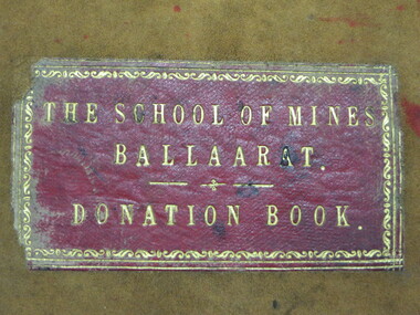
Book - Ledger, Ballarat School of Mines Donation Book, 1878 - 1895, 1878-1895
The Donation Book relates to the Ballarat School of Mines Museum which opened in 1872. Very few of these items are still held by Federation University. The Museum was emptied in the 1960s with items being distrubuted to the Ballarat Historical Society, returned to original lenders (ie Pern Collection), of disposed of. Donations to the Ballarat School of Mines include: 34. M. Hamburger, Ballarat - bunsen burner 41. W.H. Shaw, Phoenix Foundry - 81 nos of 'Engineer' 89. Juvenile Industrial Exhibition Association Committee per Joseph Flude - dies used for striking medals awarded to successful exhibits. 165. Ferdinand Von Mueller 172 Ferdinand Von Mueller o hortus siccus 6 197. James Stoddart 203. Edward Gazzard, North Creswick - Model of safety Cage invented and made by donor 218. E. Morey 222. Alfred Lestor 228. J.J. Sleep, Ballarat, patent Lever escarpment Clock (displayed in laboratories) 237. Bernard Smith (Warden) per favor of James M. Bickett - Bust of Mr John Lynch, Smythesdale. (Note: This item is not in the present Federation University Historical Collection) 241. James Oddie, J.P., Ballarat, Copy of 'the Chemist and Druggist' 267. John Lynch Junior, Smythesdale - Cast of "Golden Age" nugget, found at Browns by Co-operative party, 12 men. Weight 75 oz, 12 dwts, 12 grs.(Note: This item is not in the present Federation University Historical Collection) 270. Isaac Davis, Main Road, Ballarat 294. W. H. Shaw, Ballarat - 94 nos of 'The Engineer' 295. Rivett Henry Bland, Clunes - Specimen of water pipe from the Port Phillip Company's mine encrusted with carbonites of lime and magnesium (Note: This item is not in the present Federation University Historical Collection) 299. D.J. Williams, Queenscliff - 1 case shells from Fiji 305. C. Retallack, Ballarat 314. William Henry Shaw, Ballarat - glass case 323. W. Longley, Ballarat - Botanical Specimen (Note: This item is not in the present Federation University Historical Collection) 327. W. H. Angove, Perth 337. J. Cosmo Newbery, B Sc, Melbourne 343. James Hector, M.D., New Zealand 353. R.S. Mitchell, Ballarat - 8 specimens live plants (medicinal) (for the Ballarat School of Mines Garden) 355. W. Magee, Ballarat - Sugar cane plants and seeds (for the Ballarat School of Mines Garden) 363. James Hector, Wellington, new Zealand 371. William Wesley, 28 Essex St, Strand, London - Scientific book circular 380. Jacob Upfold (deceased) per favor of the trustees - bequest of steam engine indicator and belongings (boothe and case) 381. Joseph Mitchell, 22 Macarthur Street, Ballarat - sod of turf cut from Warboy's High Few, County Huntingdon, England, 1872. 394. W.H. Barnard 401. James Orr 418. F. Ratte, Sydney 440. Alfred Mica Smith, Sandhurst (Bendigo), Inaugural Address, delivered to the Bendigo School of Mines Science Society, June 20. 1881 by P.H. Macgillivray, MA, MRCS, FLS, President. (Note: This item is not in the present Federation University Historical Collection) (Note: This item is not in the present Federation University Historical Collection) 446. C. C. Shoppee, Ballarat 462. Dr Bunce, Ballarat 468. James Black, Mining Manager "Kerrit Bureet' 479. J.S. North, Mining Manager No. 2 Queen Co, Black Hill Ballarat. 505. Smith Tibbitts - A block of ancient leaves from the Nigtingbool Estate near Haddon on the Ballarat district from shaft 80 feet deep. (Note: This item is not in the present Federation University Historical Collection) 512. F.W. Niven, Ballarat - "A Handy Book to Tasmania" 522. James Hector, Wellington, New Zealand 549. C.E. Grainger, Manager Ballarat Woollen Mills - samples of dyed and raw wools 600. (4 July 1882) Henry Sutton, Ballarat - 13th annual report of the Aeronautical Society of Great Britain; 2 papers from the Proceedings of the Royal Society, nos 217 and 218- 1882, "One a new electrical storage battery by Henry Sutton, Ballarat, Victoria. 608. H. Glenny J.P., Ballarat - Specimen of Asbestos from Tasmania 610. M.H. Edelmann, Munich, Germany 674. W.H. Shaw, Phoenix Foundry - Steel boring 95 feet long taken from bed-plate of locomotive engine. 675 - H.R. Hancock J.P. pre favour Mr James Pryor, Moonta Mines 676. Baron Ferdinand Von Mueller KCMG, etc, Melbourne 678. E.F.A. Gaunt, Royal Navy, H.M.S. Nelson, per favour Lyde Gaunt - Specimen of manganese ore from the mines - Russell - New Zealand 728. Dr Pinnock, Ballarat 760. Simon Morrison, Ballarat 784. James Shugg, Hamilton - 1 case fossils from Muddy Creek, near Hamilton. (Note: This item is not in the present Federation University Historical Collection) 786. W. Bolam (inspector of Schools), Melbourne - 2 spears and 1 fishing prong Fijian 806. James Oddie, Ballarat 708. Henry G. Hanks, San Francisco 786. W. Bolam (Inspector of Government Schools Melbourne) - 2 spears and one fishing prong Fijian 824. Henrique Gorceixm Onro Preto, Brazil 840. W. Laplau, Ballarat - Gas furnace with a large assortment of fittings, also large gas holder and oil-heating apparatus 854. Robert Borch, Main Road, Ballarat - Improved safety chain (Note: This item is not in the present Federation University Historical Collection) 928. James Oddie 944. James P. Munroe, Registrar, Massachusetts 952. L.E. Cutter per favour of Mr F.J. Martell - Unexploded bomb shell from the Eureka Stockade 957. H. Glenny, Hobart 962. George Hart, Ballarat - eagle 976. Henry Sutton, Ballarat - 1 volume "Plattner on the Blowpipe" 978. J.W. Flatow, 45 Madeline Street, Carlton, Melbourne 984. Charles C Shoppee Ballarat - Copies of ancient coins 989-95 - Specimens from Moonta, South Australia 985. W.H. Wooster BOlwarra - books microscope related 1179. James Oddie - Live hedgehog 1181 C. Crisp, Bacchus Marsh, Portugal Copper Coin, 1785 1248 James Oddie, Solomon Islands - Bow and arrows & Spears 1285. C. Colyer, Smythesdale 1327. John L. McKenna, Smeaton - Fragment of Stone Axe. 1395. Mrs O. Skoglund, Nerrina 1428. Daniel Brophy, Ballarat - Collection of mineral specimen form Silverton (Collected by Mrs James Murray) 1442. Henry Sutton, Ballarat - Specimens of fossil fruits collected at Haddon by Charles Brown. 1444. Mining Department - Underground Mine Workings from Band of Hope and others. 1517. W.H. Wooster, Ballarat 1592. Bishop of Ballarat - Stone Axe and other native items 1669. H. McHaffier, Napoleons - 1 Spanish silver coin 1681. James Oddie, Dunedin 1688. W. Burbridge, Ballarat - Native Tomahawk from Metung 1708. A. Doepel, Ballarat 1712. Marty Guerin, Ballarat 1735. Bella Guerin. M.A., Ballarat - Copy Wide Awake Vol 1 No 7 May 28th 1887 and The Bulletin, March 19th 1887. 1747. Bella Geurin M.A., Ballarat - Copy Wide Awake Vol 1 No 8 June 4 1887 1751. Bella Geurin M.A., Ballarat - Copy Wide Awake Vol 1 No 9 June 11th 1887 1842. Linnean Society, London England - Charter, By Laws, Proceedings, Transactions, Journals 1853. W.J. Corbould, Silverton, NSW - chloride of silver from Pinnacles, Broken Hill, Silverton 1888. W. J. Corbould, Sample of metallic silver from Silverton, NSW 1928. E. Morey, Ballarat - Steam Engine 1937. Henry Sutton A.S.I.E., Ballarat - Plate Electric Machine, chimes and Sportman (number crossed out) 1951. Henry Sutton A.S.I.E., Ballarat - Plate Electric Machine, chimes and Sportman 1981. Harrie Wood (per W.H.B.[Barnard?), Ballarat 1996. W.H. Shaw, Phoenix Foundry - Papers "The Vict Engineer July 1887, May June July August 1888 and others 2014. Harrie Wood, Sydney - Report Department of Mines, 18872027. W.J. Bechervaise - Copy of Book by Baldwin Spencer 2034. A.G. Randall - Native Hatchet 2045. W.H. Corbould, Silverton, Collection of silver ores 2051. Fowler, Tarnagulla - Native Tomahawk 2123-2131. James Oddie, London 2163. Roff. F. Taplier, Sturt Street - Native Tomahawk 2178. Syd. Johnson, Meredith - Native Tomahawk, Greenstone 2184. Mr Tupp for Hall - Native Spear and Club 2292. Emmanuel Steinfeld, Melbourne 2313. A. Atwood, Rowlands Factory, Dana Street 2361. Dr Pinnock, Ballarat - Collection of Living Sponges 2363. P. Curnow, Ballarat - Piece of wood with stone naturally embedded 2364. R. Dowling, Waubra 2875. Mrs C, Flude, Ballarat - Collection of (5) mineral specimens 3460. Joseph Weir, Ballarat - Sample of rolled Annibar 3466. J. Hart, Ballarat - Native Shield - supposed to have been made by King Billy 4784. Mr. O. Woolnaugh, Pleasant Street - Four Native Tomahawks 6469. L. Balhausen, Ballarat 3472. John English, Smeaton - three samples of auriferous wash dirt 3607. Columbia College, New York - Handbook of Information of the Columbia College in the Ciry of New York 1892-3. 3672. L.A. Samuels, Bendigo 3724. P. Paperhagen 3736. The Late Rivett Henry Bland per John Noble Wilson - Collection of mineral specimens and fossils 3752. G.A. Denny, South Africa 3755. J. Carroll, Ballarat - Specimen of Native bread found in Ballarat East. 4765. J. Donnelly, Springs, Bungaree I. Fowler, Coolgardie, Specimen of Gold Bearing Quartz ballarat school of mines, doantions, museum, ballarat school of mines museum, safety cage, botanical garden, materia medica garden, library, bella guerin, james oddie, phoenix foundry, w.h. shaw, john lynch, henry sutton, aboriginal, stone axe, tomahawk, geological specimens, moonta, fedinand krause, oddie collection of minerals, thomas bath, spears, solomon islands, king billy, bows and arrows, ancient coins, birds eggs, snakes -
 Federation University Historical Collection
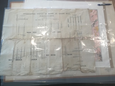
Plan, Underground Survey of Mines at Spring Hill - Sections
This plan is associated with former Ballarat School of Mines Student Richard Squire (1875-1876). Printed (in black ink) sections of underground mines on cream paper. 120 feet to one inch scale.Numbers written in pencil along bottom of plan. madam berry, lord harry, berry consols, west loughlin, loughlin, west ristori, ristori, mining, gold mining, gold, underground survey -
 Federation University Historical Collection
Book, Glenfine South and South Berry Journal
This Book is associated with former Ballarat School of Mines Student Richard Squire (1875-1876). Gift of the Squire FamilyGreen water marked linen covered journal with maroon spine with red feint lined blue pages. Label on front cover is cream with black printing JOURNAL with handwritten DATA RISIS GLENFINE SOUTH -SOUTH BERRY G.S & S.B Hand written in black and red ink. Plan in back with scale 20 chains to one inch - Has an index. Handwritten on title page in black ink Address of sawmiller T. J. Brown, Mount Rowan D. W. Hambly 317 Ligar St, Ballarat J. Freeman, C/O Mrs H Simons, Lynch St, Footscray Sleemans Prescription for the bladder in 19009 Mixture No 55983 Tabloids No 55982glenfine south, south berry, sleemans, mining, gold mining, glenfine consols, reef, weights of quartz, blacksmiths tools, australian and eagle, davies south east reef drive, brawns, eaglehawk junction, simons letter, machinery, puddlng plant, poppet heads, winding plant, creswick, mosquito creek, frenchmans gully, spring hill, a. h. welsh, squire, petticoat gully -
 Federation University Historical Collection
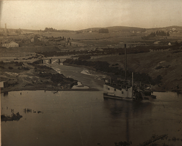
Photograph, Gold Dredge
Black and white mounted photograph of a dedge floating on a body of water which has a creek flowing into it, and rolling hills in the background. The buildings associated with a mine or factory are shown on the top left hand side. Signed "Martin ?ish Victoria St" verso "R.H. Brooke, "Callantina Villa", Glenferrie Rd Sthdredge, dredging, mining, river, callantina villa, gold mining -
 Federation University Historical Collection
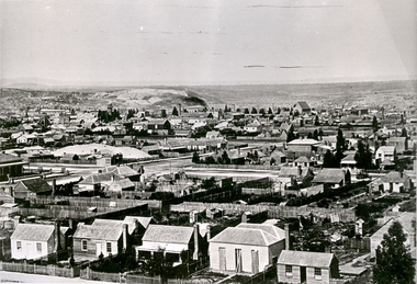
Photograph - black and white, Ballarat Looking Towards Black Hill, c1870, c1870
A black and white photograph, and two details, showing Ballarat from the Ballarat Benevolent Asylum. Evident in the photos are houses, gardens, shingle roofs, fences, St Patrick's Cathedral, Black Hill, Ballarat West Fire Brigade tower, mine dumps, mullock heap, large chimneys.ballarat, ballarat townscape -
 Federation University Historical Collection
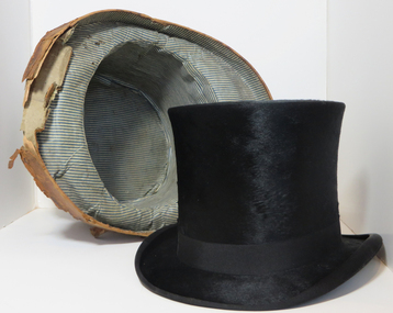
Headwear - Costume, Top Hat by W. Gribble & Co, c1920
The firm W. Gribble & Co. are associated with the long-term President of the Ballarat School of Mines Council, Bill Gribble.Black top hat with black band purchased at W. Gribble & Co. Ballarat, possibly by Peace Brown. The hat was made by Woodrow Hatters, Piccadilly, London, circa 1920. A black fur felt top hat with black band. Lined with white fabric and pale calf leather.Printed on inside white cloth: Woodrow and Sons Hat Manufacturers To H.M the King, Manchester, Piccadilly, Liverpool. Extra Quality. Made in England for W. Gribble & Co., Ballarat. On the leather is stamped Manufactured by Woodrow & Sons; Undyed Calf Leather; Made in England for W. Gribble & Co. Ballarat. Handwritten on leather: Adams and Tully. Swan Hilltop hat, gribble, gribble & co., peace brown, costume, woodrow & sons, headwear, adams and tully -
 Federation University Historical Collection
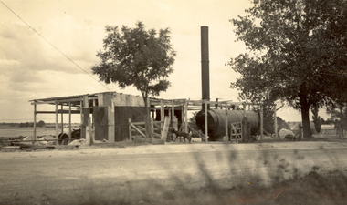
Photograph - Photograph - Black and White, Leviathan Mine, Cambrian Hill
... Leviathan Mine, Cambrian Hill Photograph Photograph - Black ...Donald Mather designed and built the pilot plant at the Leviathan Mine. Black and white photographs of the Leviathan Mine, Cambrian Hill, Ballarat, including the head frame. .2) Two men in front of a chimney at the Leviathan Minedonald mather, mather, leviathan mine, pilot plant, head frame, steam, boiler, dog, cambrian hill -
 Federation University Historical Collection
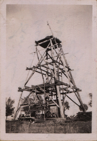
Photograph - Photograph - Black and White, Leviathan Quartz Ballarat South Cambrian Mine
Eight photographs relating to the Leviathan Mine, Ballaratleviathan, poppet head, kibble, jack scott, mining, robertson, pitfield, cambrian hill, donald mather, leviathan quartz mine ballarat south, cambrian mine -
 Federation University Historical Collection
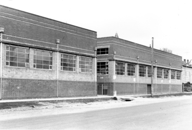
Photograph - Photograph - Black and White, Ballarat School of Mines Buildings, Albert Street, c1970
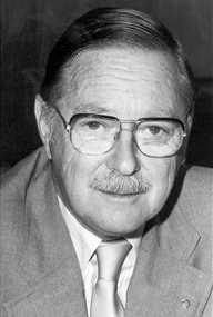
Kenneth Joynson Flecknoe joined the Ballarat School of Mines Council in 1979 becoming its 11th President in 1981. He joined the Ballarat Courier newspaper in 1953 as company secretary, becoming General Manager in 1966. Flecknoe joined the board of directors in 1968 and was managing director from 1969 until his retirement in 1987. Flecknoe was chairman of the Ballarat Broadcasters Pty Ltd (3BA), of the gateway Publishing Company which published newspapers in Ararat and Stawell and of the Ballarat Publishing Company which published Ballarat News, and was formerly deputy chairman of associated Broadcasting Services Ltd (BTV6 Ballarat and GMV Shepparton). He was also Chairman of the advisory board of Ballarat's St John of God Hospital. Flecknoe's contribution to the Royal South Street Society, of which he was a past president, and a committee member since 1961, was rewarded with life membership. He was also a life member of the Ballarat Historical Park Association (Sovereign Hill). The Ballarat School of Mines building in Albert Street was named "Flecknoe" in 1991, three years after Flecknoe's death.Three photographs showing a Ballarat School of Mines building on Albert Street. .1) Ballarat School of Mines Building, Albert Street .2) View of Carpentry Building looking towards Albert Street .3) Building on the Ballarat School of Mines Building (Possibly the former caretaker's cottage), near Albert Streetballarat school of mines, albert street, flecknoe, carpentry, vocational skills, ken flecknoe, flecknoe building -
 Federation University Historical Collection
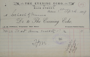
Book - Scrapbook, Ballarat School of Mines Invoices, 01/07/1895 - 05/05/1899
The invoices glued into the scrapbook relate to purchases from the Ballarat School of MinesA very large dark green hard covered volume with read leather face spine and corners. Black ornamental bands across the spine. Leather strap with buckle for securing covers when not in use. Plain pages of brown "wrapping paper". Receipts glued to pages, folded and then numbered consecutively by hand i blue pencil. First receipt No. 996 (01 July 1895), numbering restarts after 1000 (three times). Last receipt is No. 155 (05 May 1899).invoices, ballarat school of mines, tunbridges, pringle, receipts, w. hamer, plumber, eyres brothers, j.h. trotman, g. batchelor, n. guthridge, w. doepel, frank fiscalini, huddart, barker and co., a. gaunt, h. wardle and son, turron & mcgavin, e.e. campbell, g.f. hocking, william sutherland, f. vale, victoria insurance company, r. collie & co., walter cornell, john fiscalini, mcvitty & co, j. miller & co, a.g. corbett, ben franklin printing works, middleton & morris, melbourne glass bottle works co, eldon chambers, e.l. stubbs, j. jones, firewood, mrs soderstrom, museum, ballarat school of mines museum, hill & paine, h. hebestadt, f.w. commons, sculptor, cherry & robins, alex e. monsbourgh, alex purdie, andrew cant, ballarat star, frederick martell, goodfellows, evening echo, a.h. powell, phillately -
 Federation University Historical Collection
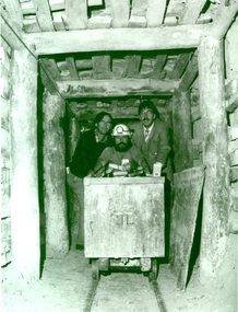
Photograph - Black and White, 1988, Three men standing behind a trolley in a mine tunnel, 06/1988
This image was taken at the conclusion of a special eight week "Crash course" in mining, requested by Eastern Reefs. It was used in the Ballarat School of Mines Review, 1988, page 7.Black and white image of three men standing behind a trolley in a mine tunnel showing supporting beams (thought to be Sovereign Hill) They are from left to right Ernie Terrill (Ballarat CES), Raymond Collins (Ballarat School of Mines Mining Student) and Malcolm Vallance (Ballarat School of Mines Special Projects Manager).ballarat school of mines, mines, mining, mining trolley, mine truck, mining railway, malcolm vallance, mal vallance, raymond collins, ernie terrill, eastern reefs, sovereign hill, mining education -
 Federation University Historical Collection
Photograph - black and white, Ballarat School of Mines Staff, Industry and Training Division
Ballarat School of Mines Staff, Industry and Training Divisionballarat school of mines, industry and training, mal vallance, linette penhall, lauren malone, dough sarah, donna agnew, martin hill, janette pearson, jane auchettl -
Federation University Historical Collection
Book, Historic Sites Survey: North Central Study Area, 1979, 1979
The North Central Study Area included the Shires of Avoca, Bet Bet, east Loddon, Goulburn, Untly, Kara Kara, Korong, Maldon, Marong, Metcalfe, McIvor, Newstead, Strathfieldsaye, Stawell, Talbot, Clunes, Tullaroop and Waranga. 153 page book with white plastic binding. It is an historic sites survey for the North Central Study Area commissioned by the Land Conservation Council, the Ministry for COnservation and the Australian Heritage Commission. castlemaine, mount alexander goldfield, maldon, percydale, warrenmang, moliagul, tarnagulla, stuart mill, the whipstick, whroo, rushworth, graytown ironbark forest, st arnoaud, new bendigo, landsborough, inglewood, kurting, wedderburn, wehla, kooroora, langham flat, mcintyre, rheola, diamond hill, fosterville, coliban water works, green gully, newstead, muckleford forest, costerfield, graytown, bailieston, waranga irrigaiton system, eucalyptus distillery, mia mia bridge, korokubeal township researce, concegella slate quarry, chewton, fryerstown, kingower, timor, talbot, majorca, carisbroook, clunes, st arnaud, taradale, icomos, dunolly, limestone, castlemaine slate quarry, harcourt granite, taradale railway viaduct, loddon united waterworks trust, gouldburn weir, carisbrook lock-up, history of tree planting in streets, history of public reserves, r.u. nicholls nurseryman, thomas lang, francis moss, ballarat botanical gardens, ballarat school of mines botanical gardens, lake wendouree, victoria park, ballarat, muont holled smith, ballaarat old cemetery planting, eastern oval, ballarat east botanical gardens, ballarat east town hall gardens, eureka stockade reserve, ballarat observatory plantings, yarrowee creek plantings, yarrowee bluestone channels, ballarat woollen mill, band and albion mullock heap, black hill plantings, yarrowee creek channels, canadian creek channel, specimen vale channel, poverty point reserve, union jack reserve buninyong, imperial mine, buninyong, victoria street plantings, bridge mall, sturt street gardens, ballarat avenue of honour plantings, white flat oval plantings, camp street, elms, burnt creek -
 Federation University Historical Collection
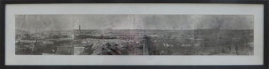
Photograph - Photograph - Black and White, Ballarat, c1858, c1858
Four photographs framed together to produce a panorama. The four photographs were taken from the slope of the Ballarat School of Mines where the Wesley Church now stands. When joined they gave a panoramic view of one of the world’s richest alluvial goldfields. The town you see had over 50,000 people. Bridge Street on the left is well established. The crude pans and cradles of the early “diggers’ were already giving way to steam power and the deep shafts of the “miners”. Money and machinery were needed to get to the deeper leads, and the smoke stacks of the great company mines can be seen across the photo. The waterloo mines was one of the first deep shafts and was sunk at the foot of the Dana Street hill. Its tailings are seen in the second photo from left. ballarat, ballarat gas works, mount warrenheip, shingle roof, mullock heap, mining -
 Federation University Historical Collection
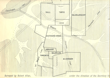
Plan, Underground Survey of Mines, Ballarat East, 1885, 09/1889
Surveyed by Robert Allan under the direction of the Secretary of Mines.Rectangular plan showing placement of mines in 1889. Mines include Hick's and Gilpin's lease, Comstock, Melbourne Company, Victoria United, Speedwell Company, New Normanby, Pasha Surprise, Central Sulieman, West Llanberris, Britannia United, Victoria Unites, Clinton's, Orient Company, North Sulieman, Sulieman Extended, Pasha Surprise, Golden Fountain, Prince regent, Clark and Company, Tinworth, North Woah Hawp, Detering, R.A. Thompson, Dazelles and buchanan, Barnett, Braybrook, Ladt Cornwall, Hanthorne, Dalzelles and gay, Southern Cross, M. Acheson, Cricket Reserveballarat east, mines, mining, underground survey, robert allan, chinese, ah chong, ah young, bakery hill, black hill, black hill lead, bakery hill lead, cricket, pennyweight hill, gravel pitts lead, golden point lead, navy jack's lead, mopoke lead, eureka lead, association lead, warrenheip lead, cgt, plans -
 Federation University Historical Collection
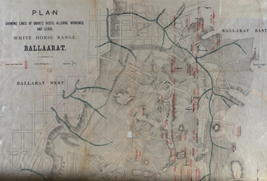
Plan, White Horse Range Ballarat, 1885, 06/1885
Two plans .1) Plan of the Ballarat Goldfields showing leads, rivers, streets and topography. Quartz reefs include: Yorkshire, Try Again, Promised Land, Western Slates, Norwegian, Robert's Lode, Finn's, Band and albion, Rothschild, Old Post Office, Queen Lode. Leads include: Navy jacks, Gays, Canadian, Prince Regent, Sailors Gully, White Horse, Little White Horse, Milkmans, Nightingale, Golden Point, Gravel Pits. Scale is 8 Chains to 1 inch .2) Plan showing lines of quartz reefs, alluvial workings and leads, White Horse Range, Ballarat. Leads include White Horse LEad, Little White Horse Lead, One Eye Gully, Terrible Lead, Sailor's Gully, Canadian Lead, Prince Regent Gully, Canadian Lead, Cavs Lead, Navy jacks Lead, Eureka Lead, Old Gravel Pits Lead, Gravel Pits Lead, Nightingale Lead, Malakoff Lead, Milkmans Lead, Redan Lead, Woolshed Lead, Jacksons Lead, Winters Lead, SCtochman's Lead, Canadian Lead. Reefs include: Promised Land, Daniash, Sir Garnet Wolsley, Norwegian, Rothschile, Band and Albion, Finns, Llanberis, Roberts Lode, Tynworths and Black Hill, Oregan, Yorkshire, Try Again, Yorkshire, Post Office, Clarke's, Western Slates, Black Slate, Danks Slates, Eastern Slates, Queen's Lode, Fire Brigade. Mines include Red Streak, New Chum, Tinworths, Woah Hawp, Normanby, Speedwell, Llanberris Extended, Llanberis, Last Chance, Major, Countess, Pioneer and a number of batteries along Main Road Hills include: Mount Clear, Pennyweight Hill, Sovereign Hillballarat, plan, white horse range, white horse, goldfields, mines, reefs, indicators, leigh river, cgt, tinworth, mining -
 Federation University Historical Collection
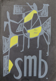
Magazine - Booklet, Ballarat School of Mines Students' Magazine, 1962, 1962
Ballarat School of Mines Students' Magazine, 1962. Editorial, Prominent Personalities, The Principal's Pages, The Richard W. Richards Medal, The Challenge, Camera Portraits, Conferring of Diplomas, The Highest Distinction - the F. J. Pomeroy Cup, What is Mathematics?, Microliths, Begonia Festival Procession, In a Man's World, Retirement of Mr. Harold Yates, The Eric McGrath Award, Asian Students in the S.M.B., Austral-Asian Relationships, Originality - At What Price?, Sports Awards 1962, Sports, The BEAT Generation, University in Ballarat, Heads of Departments 1873 - , Associates Black soft cover with grey inscriptions and grey and yellow figures on front cover, 72 pagesOn one of the first two loose pages there is the inscription "Copy uncollected by student but paid for, used to cut our advertisers' copy, 15/08/63".ballarat school of mines students' magazine 1962, staff, sports, stanley white, kelvin whitford, eric mcgrath, ian weir, gordon johnson, kerry penna, kevin oscar rogers, robert coutts, graeme waller, anita bitans, noel kelly, john davis, tony brauer, sue davies, h. e. arblaster, w. h. reimann, a. j. bethune, william peter john huberts, d. pollard, john boermans, james william beattie, edward westlake doney, john maxwell gilbert, barbara anne o'conell, helen margaret ross, robert william tantau, jeffery murrell, barry thomas dunstan, juris erdmanis, sr. mary andre power, james william john, walter henry reimann, donald james stewart, ronald william furlong, kenneth joseph howard, allan graham rock, robert geoffrey champneys, denis richard colbourn, wilhelmus peterus johannes huberts, neil herbert andrews, john barry gillick, charles edwin goddard, donald william pope, william henry saggers, ronald charles davis, travers william duncan, brian thomas hickey, robert reginald archer, kaspars bitans, robert william lochhead, tony white, teng seong khoo, robert frederic murrell, john william faulkner, harry w. goldsmith, h. darby, don holmes, j. r. pound, david james, ross gray, harold yates, w. l. moore, teddy gan, m. moissinac, c. gan, b. tanthiem, l. k. oh, b. eng, doug rash, d. holmes, t. c. poh, b. saw, s. wendt, p. malins, d. a. black, g. biddington, borom tanthiem, edward elsbury, w. lancaster, mount isa mines, eric mcgrath award, ballarat school of mines revue, electrolytic zinc companyof australasia limited, m.b. john, b. and g. myers, broken hill associated smelters -
 Federation University Historical Collection
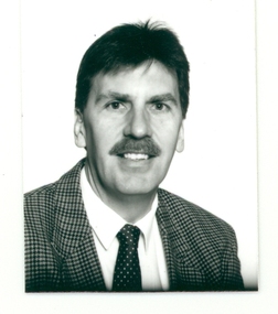
Photograph - Black and White, Ken Flecknoe
Kenneth Joynson Flecknoe joined the Ballarat School of Mines Council in 1979 becoming its 11th President in 1981. He joined the Ballarat Courier newspaper in 1953 as company secretary, becoming General Manager in 1966. Flecknoe joined the board of directors in 1968 and was managing director from 1969 until his retirement in 1987. Flecknoe was chairman of the Ballarat Broadcasters Pty Ltd (3BA), of the gateway Publishing Company which published newspapers in Ararat and Stawell and of the Ballarat Publishing Company which published Ballarat News, and was formerly deputy chairman of associated Broadcasting Services Ltd (BTV6 Ballarat and GMV Shepparton). He was also Chairman of the advisory board of Ballarat's St John of God Hospital. Flecknoe's contribution to the Royal South Street Society, of which he was a past president, and a committee member since 1961, was rewarded with life membership. He was also a life member of the Ballarat Historical Park Association (Sovereign Hill). The Ballarat School of Mines building in Albert Street was named "Flecknoe" in 1991, three years after Flecknoe's death.Photographic portraitken flecknoe, ballarat school of mines, ballarat school of mines council, ballarat courier -
 Federation University Historical Collection
Booklet - Report, J.J. Gourley (Government Printer), Department of Mines Annual Report, 1950, c1950
Thirty six page foolscap booklet with some black and white photographic image. It includs statistics relating to the mining industry. Images include Limestone Quarry at Cave Hill, Lilydale; Golden Retriever nuggett; The Wedderburn Dog nuggett; Moning Star Mine, Wood's Point; shallow drilling; penicillin tanks; Mines Department Laboratory; Charging; Aurora Mine, Daylesford; Hattietville Dredge; North Deborah Mine, Bendigo; Central Victorian Dredge, Strangwaysj.g. gouley, mining, coal, gold, silver, geology, boiler inspection, leasing, gold buyers act, lilydale, fireclay, harrietville dredge, aurora mine daylesford, williams reward mine daylesford, strangways dredge, north deborah mine bendigo, statistics, bendigo mine, department of mines victoria, annual report, statistics relating to mining industry -
Federation University Historical Collection
Book, Northern Territory of South Australia Report Resulting from the Explorations by the Government Geologist, 1906, 1906
Pale blue soft covered geological and general report. It includes a chapter of Bathurst Island and Melville Island, Primitive Methhods of Chinese Mining, Early Days of Mining in the Northern Territory Images include sandbank at low tide, Douglas River, Granite at Union Hill, Night Cliff, East Point, union hill, zapopan gold mine Brook's Creek, Blow Gold Mine Yam Creek, Daly River Copper Mine, Mount Ellison Copper Mine, Point Charles Lighthouse, Blacks Camp near Point Charles Lighthouse, The Venture Stranded on a Daly River Sandbank, Hyland Bay Natives, Boabab Trees at Blunder Bay, The Wai Hoi, Mouth of Fitzmaurice River, Point Blaze Natives, Fort Hill and Old Gulnare Jetty Port Darwin, Large Anthill, Daly RIver Natives, Wargie Natives, L.C.E. Gee, H.Y.L. Brown, H. Basedow. F.J. Williamson, Aboriginal crew (Pedro, Peter, Tobatchie, Bubs, Loman), Henry Roberts, Schollert's Grave It also includes a large folder Geological Map of the North-Western District Northern Territory of South Australia. northern territory of south australia, geology, l. o'loughlin, douglas river, bathurst island, melville island, apsley straight, chinese, aboriginal -
 Federation University Historical Collection
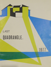
Magazine, Quadrangle: Magazine of the Ballarat Technical School, 1977, 1974
In 1977 the Ballarat Technical School was closed, and officially removed from the list of post-primary schools in Victoria on 01 January 1977.Blue, yellow, black and white soft covered magazine. It includes a history of the Ballarat Technical School. The magazine lists ex students who played AFL football at the highest level, namely Michael Malthouse (Richmond); Val Perovic and Robert Muir (St Kilda), Don Disher (Ballarat, winner of Henderson Medal) ballarat school of mines, ballarat junior technical school, ballarat technical school, d.j. seymour, kevin murrray, w.e.c. loughnan, central technical school, s. salo, p. nicholson, f. bishop, malvina fullerton, g. gardoz, g. hynd, trevor hill, roymond borner -
 Federation University Historical Collection
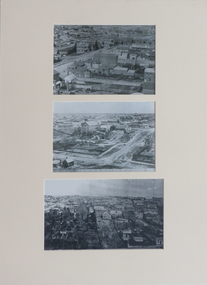
Photographs, Three Reproductions of Early SMB buildings, 01) - .2) 1872 .3) 1948
Three mounted black and white reproduction photographs depicting early SMB buildings .1) View of Ballarat Gaol, Old Court House and Wesley Church .2) Lydiard St South .3) SMB buildings 75 years laterblack and white photography, smb campus, lydiard street south, ballarat old court house, former wesleyan church, ballarat school of mines, dana street hill -
 Bendigo Historical Society Inc.
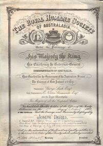
Document - JOSEPH DAVIES COLLECTION: ROYAL HUMANE SOCIETY OF AUSTRALIA AWARD, 16/07/1909
Illuminated scroll document awarded to Joseph Davies by the Royal Humane Society of Australia for rescuing John Allan from the effects of an explosion in the Goldfields Consolidated Gold Mine at Bendigo on July 16th., 1909' Document is written in copperplate script on parchment coloured paper enclosed in a black outer covering. Written in gold on outer black covering 'The Royal Humane Society of Australasia'Royal Humane Society of Australasiaperson, mining, joseph davies, joseph davies, joseph davies, john allan, diamond hill, royal humane society of australasia -
Bendigo Historical Society Inc.
Photograph - SPECIMEN HILL GOLD MINE - PHOTO OF SPECIMEN HILL GOLD MINE
... PHOTO Specimen Hill Gold Mine Photo of Specimen Hill Gold Mine ...Black & white photocopy of a photo of the Specimen Hill Gold Mine, Eaglehawk. Photo shows poppet legs, bins, building, chimney (with flange near the top), and mullock heaps in the foreground.photo, specimen hill gold mine, photo of specimen hill gold mine -
 Bendigo Historical Society Inc.
Photograph - NEW RED, WHITE & BLUE CONSOLIDATED MINE - PHOTOS OF THE NEW RED, WHITE & BLUE CONSOLIDATED MINE
Three black and white photos of the New Red, White & Blue Consolidated Mine. (a) is a small photo of the poppet legs and buildings. There are mullock heaps on the right of the picture. In the foreground are grass and a shrub. There is also an area of sand. On the back is written: New Red White and Blue Consolidated. Originally the Union Shaft. (b) is a photo of the poppet legs and buildings with a large chimney. The overhead tramway is behind the buildings. A man is standing in front of the buildings. There is grass in the foreground. Written on the back: New Red White & Blue Consolidated. Near Dairy Hill Golden Square. (c -) Photo of the buildings, poppet legs and tramway going from the poppet legs to a tall building. The building on the left has a tall chimney. On the front of this building is a sign with the name of the mine on it. In front of the building on the right is a large fuel-type tank with two ladders leaning against it. Written on the back: New Red, White & Blue Consolidated. 2,416 ft.photo, new red, white & blue consolidated mine, photos of the new red, white & blue consolidated mine, union shaft, dairy hill golden square -
 Bendigo Historical Society Inc.
Photograph - UNITED GARDEN GULLY CLAIM
... mining mine Victoria Hill black and white image mounted on yellow ...black and white image mounted on yellow board, part of a joined series of three, image shows open cut, the United Garden Gully claim, looking towards Victoria Hill.business, mining, united garden gully, united garden gully, bendigo, mining, mine, victoria hill -
 Bendigo Historical Society Inc.
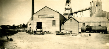
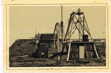
Photograph - EXCAVATIONS 180 CLAIM VICTORIA HILL ( COULD BE GARDEN GULLY )
... BUSINESS Mining 180 mine Lansell's 180 mine Victoria Hill Bendigo ...black and white image mounted on yellow board, part of a joined series of three, image shows excavations for 180 claim on Victoria Hill. Large poppet head in front, smaller one behind., pile of mullock on LH side, small shed beside. James Lerk 24.3.2000 ' looking north towards the 180 mine' ( could be Garden Gully )business, mining, 180 mine, lansell's 180 mine, victoria hill, bendigo, mining, mine -
 Bendigo Historical Society Inc.
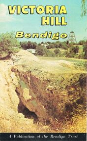
Document - JOAN O'SHEA COLLECTION: VICTORIA HILL GOLDMINING AREA BOOKLET, March 1972
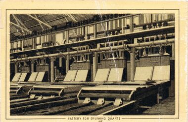
Joan O'Shea Collection. Victoria Hill Bendigo Gold Mining on the Richest Quartz Reef in Bendigo, from 1854 to 1916. Colour and Black and White Booklet 16 Pages. Includes Maps of the Victoria Hill Area, photographs of the remains of a twenty head crushing battery, burnt ground from quartz roasting, The Victoria Quartz Mine Photograph from Australian Mining Standard June 1899, The compressor beds and concrete foundations for the poppet legs all that remain today of the Victoria Quartz Mine deepest mine on Bendigo Goldfield 4613 feet or 1406.04 metres. Also included photograph of the view of Victoria Hill from The New Chum Hill in the 1870s. The Location of the 3 mines Ballerstedt's open cut, North Old Chum and Lansell's 180 are marked. A depiction of Rae's Open Cut gives an understanding of the primitive nature of early workings on the Goldfields. The Booklet also provides a brief history of Victoria Hill itself.Bendigo Trust Publication March 1972. Printed in Bendigo Cambridge Press.bendigo, mining, victoria hill -
 Bendigo Historical Society Inc.
Photograph - WES HARRY COLLECTION: MINING LANDSCAPE BENDIGO
Black and white photo copy: image shows heavily mined landscape, buildings (stone ? ) on RH side, brick chimney behind, line of whims heading to hill top along reef line.Batchelderplace, bendigo, mining landscape, bendigo, sandhurst, goldmining, gold -
 Bendigo Historical Society Inc.
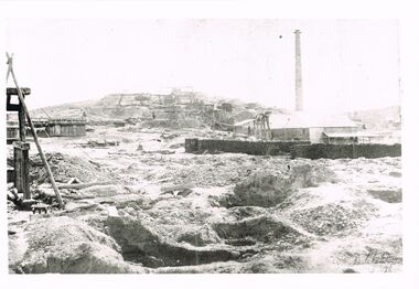
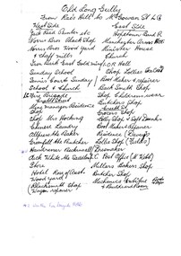
Document - LONG GULLY HISTORY GROUP COLLECTION: OLD LONG GULLY FROM RAE'S HILL TO MCGOWAN ST
Titled Old Long Gully From Rae's Hill to McGowan St. LG. West Side - Jack Read Painter etc, Norris Bros Black Shop, Norris Bros Wood Yard & Chaff Mills, Iron Bark East Gold Mine, Sunday School, Tennis Courts Sunday School & Church, LG Fire Brigade, Creeth Street, Mine Managers Residence, Shop, Shop Mrs Hocking, Chinese Laundry, Allpress the Baker, Greenfell the Butcher, Hairdresser Beckinsall was the Fire Brigade Hotel, Dick White the Saddler, Store, Hotel Rose of Australia, Woodyard, Blacksmith Shop Wagon Repairer, Hotel Kocks (Pioneer Hotel), 2 China Shops owned by Chinese, Hotel Silver mines Hotel, Police Station, Grocers Shop (per? Reef Mine Hotel) E Bryant, Mine Windmill, Church Residence, Minister. East Side - Hopetoun Band R, Manchester Arms Hotel, Minister House, Church, IOR Hall, Shop Lollies Icecream, Boot Maker & Repairer, Back Smith Shop, Shop Childrens Wear, Butchers Shop, Creeth Street, Grocers Shop, Lolly Shop & Soft Drinks, Boot Maker & Repairer, Residence (Davey's), Lollie Shop (Fields), Dressmaker, LG Post Office (M Webb), Millars Bakers Shop, Butcher Shop, Mechanics Institute Books & Paper & Billiard Room, Connell the Baker, Dr SElby, Pentreath Organ Builder & Tuner, Blacksmith Shop, Hexagon Toilet, Kocks Machine Shop, Kocks Mine Office, Kocks Material Shop, Police Station, Dyson's Dam Warm waer, Air Station, Mine Battery stone crusher 80 head approx, Kocks Mine, Needle Mine. Some notes written at the end - Norm Shotples used to have Barber Shop - he has gone to Queensland, Violet Street started off as the German School, Wells Street used to run through Victorian Consol ? the other side, Comet Hill would like a visit. Contact Helen Gorlay at Violet Street would line to some video. Alan has good info on the Long Gully School. Betty has book. Views of Bendigo. Frank Cusack - Bendigo Trust. Bendigo School Hisking? School, Violet Street. Older levels lo?ing at Architecture.bendigo, history, long gully history group, the long gully history group - old long gully from rae's hill to mcgowan st, jack read, norris bros, iron bark east gold mine, long gully fire brigade, mrs hicking, allpress, greenfell, beckinsall, dick white, rose of australia, hopetoun band r, manchester arms hotel, ior hall, davey's, fields, m webb, millars, mechanics institute & billiard room, kocks pioneer hoel, silver mines hotel, e bryant, windmill mine, pere? reef mine hotel, connell, dr selby, pentreath, kocks machine shop, kocks mine office, kocks material shop, dyson's dam, kocks mine, needle mine, norm shotples, german school, victoria consols, helen gorlay, long gully school, frank cusack, bendigo trust