Showing 59 items
matching bogong high plains map
-
 Kiewa Valley Historical Society
Photograph Farm Land, Mount Beauty Acreage before Golf Course, Circa 1950
This photograph is a "snap shot" in time circa 1950s detailing the rural environment before the effects of the Kiewa Valley Hydro Scheme altered the basic rural setting of the valley. The golfing fairway was being mapped out on previous grazing land, before the laying of a golf course, for use by the construction workers and auxiliary administration employees of the Victorian State Electricity Commission. This photograph details a dramatic period in time which saw an enormous change to the exclusively rural area of the Kiewa Valley region in the mid 1900s. This change presented both physical and mental challenges to the existing quiet rural inhabitants of the valley. The State of Victoria had to make adjustments to the changing demands imposed by population and industrial expansions. The development of cleaner energy supplies to a growing population has its downside ,which ever way the intrusion into the "natural" landscape is made.Black and white photograph detailing surveyor posts for construction of golf course. Land used, before establishment of the Mount Beauty Village, as farming/grazing cattle and viewed towards Mount Bogong and its Alpine ranges. The photo is on 200gms paper and not on photographic paper.nilmount beauty in the 1940s - 1950s, grazing in the kiewa valley, sec victoria -
 Kiewa Valley Historical Society
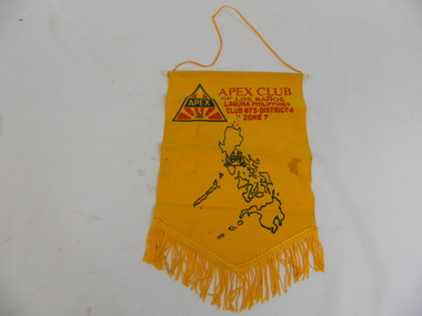
Banner & Pin - Apex Club
An Apex club existed in the Kiewa Valley. Apex clubs exchanged banners when a local member visited another club or when a member of another club visited the local club.Historical: Tas Davies belonged to the local Apex Club.Gold coloured flocked fabric banner with gold fringe at the bottom in triangular shape and cord on white plastic rod at the top. Gold coloured cord attached at each end of the rod to enable the banner to be hung. Apex gold pin attached - triangular logo on top of pin.Map of Philippines. Apex Club / of Los Banos / Laguna Philippines / Club 673.District 4 / Zone 7 Large red and green Apex logo. On pin: small red and green Apex logosocieties, clubs, community, service club, apex, banner, laguna, philippines, tas davies -
 Kiewa Valley Historical Society
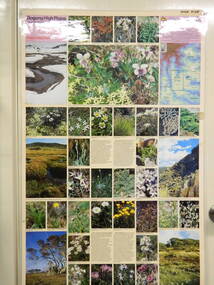
Map / Chart, Vegetation Map & Guide to Alpine Flora: Pretty Valley, 1982
This poster shows Pretty Valley is on the Victorian High Plains where the State Electricity Commission of Victoria worked on the Kiewa Hydro Scheme. Also cattle have grazed in the area over the years. This map is of interest to compare the flora in the area with times prior to 1982 and after 1982.This poster has historical and research value as it shows the flora in the pretty valley area therefore making it significant for people interested in plants. Also for those who would like to compare what plants are still in this area after 1982 and if the cattle grazing, climate change, of bush fires have had on the environment. Thus this poster also has good interpretive capacity of these reasons. Laminated double sided vegetation map and photographic guide to Alpine flora of the Pretty Valley areapretty valley. bogong. vegetation. plants. flowers. alpine. victorian high plains. cattle grazing. s.e.c.v. -
 Kiewa Valley Historical Society
Map / Chart, Vegetation Map & Guide to Alpine Flora: Hotham, 1982
This poster shows Mt Hotham is on the Victorian High Plains. This poster and map enables the comparison to be made of flora in other areas of the Victorian High Plains e.g.. which was previously known as the Bogong High Plains. This poster has historical and research value as it shows the flora in Mt Hotham area therefore making it significant for people interested in plants. Also for those who would like to compare what plants are still in this area after 1982 and if the cattle grazing, climate change, of bush fires have had on the environment. Thus this poster also has good interpretive capacity of these reasons.Laminated double sided vegetation map and photographic guide to Alpine flora of the Hotham area.hotham. vegetation. plants. flowers. alpine. high plains of victoria. -
 Kiewa Valley Historical Society
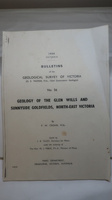
Document - Four Geological reports on the North-east Goldfields, Geological Survey of Victoria 1958 Bulletin
Geological Surveys of N.E. Goldfields Victoria included mines and tunnels. A resurvey of goldfields was necessary to re-assess economic possibilities using modern techniques and structural interpretation. It included an examination of a considerable surface area with maps and underground workings. Results were correlated and integrated and published by the Mines Department.The mines are in the Bogong Alpine Area.Foolscap printed Victorian Bulletins. Each stapled in the top left corner and each with varying number of pages. Covering 1941-1958 a) Glen Wills and Sunnyside b) Sunnyside Tunnel c) Red Robin d) Maud and Yellow Girl Government Printer, Mines Department, Melbourne, Victoriageology in the north-east, gold fields, goldmines, glen wills -
 Kiewa Valley Historical Society
Photos: Kiewa Hydro Electric Scheme x 12
K.H.E.S.Photos 4 coloured and 8 black and white with the Title printed below each one. 1. S.E.C.V. Telephone Switch Board (See also KVHS 0847) 2.West Kiewa Tunnel 3. Construction of Underground Power Station 4. Pretty Vally Camp 5.Outside Kiewa House, Bogong 6. S.E.C.V. Saucer (See also KVHS 0128) 7.Insulator Disk Struck by Lightning 8. S.E.C.V. Map of the Kiewa Hydro Scheme 9.Howman's Gap Camp 10.Tunnel Excavation Face 11. Mt Beauty Townhship 1948, looking north east 12. Mt Beauty Township - no labelkiewa hydro electric scheme photos -
 Kiewa Valley Historical Society
Maps - Bogong High Plains & Mt Beauty Township
... with Section Nos. and house numbers Maps - Bogong High Plains & Mt ...The SECV continually updated their mapsDuring the development of the KHES the SECV had to continually update their mapsBoth Foolscap 1. Titled: High Plains Access Tracks & Roads 2. Mt Beauty Street Plan by SECV with Section Nos. and house numbersBoth have sticky tape marks on their back.khes maps -
 Kiewa Valley Historical Society
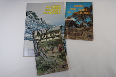
Books x3 - Walking on the Bogong High Plains, 1. The Alpine Track Walhalla to Mt Bogong. 2. Bogong High Plains and Adjacent Peaks both by John Siseman 3. Alpine Safety Manual
Books were published to guide walkers travelling long distances in remote areas increasing their safety and giving them independence.Bogong High Plains and Mt Bogong are at the upper end of the Kiewa Valley where local people and visitors spend their leisure time, walking.1. and 2. both written by John Siseman, small (pocket size), includes maps and black & white photos. The covers are colored photos with the title at the top. 1. has 78 pages and 2. has 63 pages.The Alpine Safety Manual (in yellow) is twice the size of the others and published by the Department of State Development, Decentralization and Tourism.It has 40 pages, coloured and black & white photos and is held by 2 staples.bush walking, bogong high plais, walhalla to mt bogong, alpine track -
 Kiewa Valley Historical Society
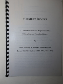
Booklet - The Kiewa Project, The Kiewa Project by Adrian Rufenacht
The Kiewa Hydro Electric Scheme was constructed by the SECVBooklet of 40 pages typed on both sides and including 4 maps at the back. It has a black plastic spiral spine and black back cover. Title on the front followed by 'Evolution of Layout and Design, Personalities / Of Early Days and Future Possibilities' followed by the authorkiewa hydro electric scheme, adrian rufenacht -
 Kiewa Valley Historical Society
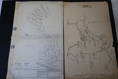
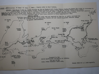
Map - Kiewa Hydro Electric Works Area
An early map of the Kiewa Hydro Electric Scheme Works Area prepared by the SECV for use when requesting access to the area. The regulations are printed regarding permits.During construction of the KHES there were restrictions on access to the area. This map identifies the land marks and states the regulations for entry to the area.Black and white map folded into three showing a legend with the townships, camps, gates and dams marked.Also indicating the roads, rivers, mountains and infrastructure of the KHES. khes works area, map of khes -
 Kiewa Valley Historical Society
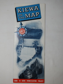
Map - Kiewa on the Map, Guide to Kiewa Hydro-Electric Project
Published by the SECV in 1950. They controlled the roads from Mt Beauty to the Bogong High Plains and all other roads within the Kiewa works area. The roads are not open to general tourist traffic. Conducted tours of the Kiewa area are operated by Eastern Road Lines Pty. Ltd., AlburyThe SECV constructed the KHES and controlled all roads within the Kiewa works area.Large colored map folded in half and then in 3. Front third is mostly blue and white with titles.. When opened the cover has black and white photos beside it with print and 'Please Note'. Also in the other half, a 'Road Map to Kiewa' showing the south eastern side of Australia, mostly yellow (the land) and blue (the sea). Inside the map is a close up map of "Ground Plan of Kiewa Hydro Electric Project' with a 'Key Map Showing Distances'.map of kiewa 1950, khes map -
 Kiewa Valley Historical Society
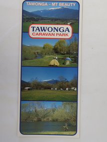
Brochure - Tawonga Caravan Park, Tawonga - Mt Beauty
Tawonga Caravan park is on the Kiewa River situated north of Mt Beauty and 30 km from Falls Creek. Tawonga Caravan park has always been popular for families and fishermen with plenty to do.Colored cardboard brochure with 3 small photos on the front and information printed on the back with a small map.tawonga caravan park, trout fishing -
 Kiewa Valley Historical Society
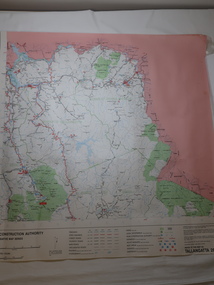
Map - Road Construction Authority 1986, Ref. Tallangatta 282008
Government authorities updated maps regularly.Historically of interest eg. 1. Pre dates the Alpine National Park. 2. 'Mt Beauty Estates' now known as Tawonga South. 3. Mt Niggerhead is named - It is now known as Mt Jaithmathang having been renamed in 2009.Colored map dated 1986 titled Road Construction Authority with an update of roads in the local Shires. It names places in the area and has a legion describing the rating of the roads and tracks. It also shows the main towns in the area and their roads.road construction authority, map of tallangatta area -
 Kiewa Valley Historical Society
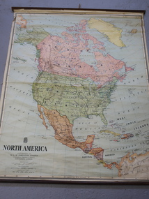
Maps - Educational x 10 and Kiewa Scheme x1
Maps were used to teach children geography, the explorers, the minerals, the world etc. The school bought and stored the maps so that they were available for use. This predated electronic devices. The KHE Works map was hand drawn showing lots of detail.These maps were used by the Bogong Primary School. The Kiewa Hydro Electric Works was built by the SECV and produced hydro power. This map may have been used by pupils as well as workers on the Works. Large coloured maps on canvas, with a wooden beam along the top and bottom. Each one has a cord attached to the top so that the map may be hung up on a wall. Some are made by Chas. H. Scally & Co., Baronia Ave., Wollstonecraft, N.S.W. The Kiewa Hydro Electric Works map is pinkish and shows Rocky Valley Dam, Lake Guy and Mt Beauty pondage in dark blue.maps, educational maps, geography, primary school, kiewa hydro electric works -
 Kiewa Valley Historical Society
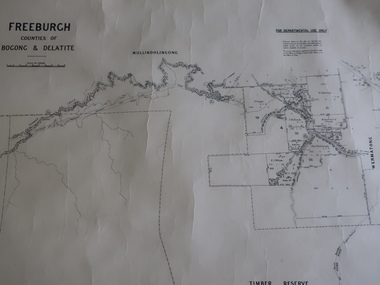
Map - Freeburgh - Counties of Bogong and Delatite
Drawn and reproduced at the Dept. of Lands and Survey, Melbourne, Victoria November 1948Black and white map of Freeburgh, County of Bogong and Delatitefreeburgh, map county of bogong and delatite -
 Kiewa Valley Historical Society
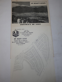
Folder - Mt Beauty Estate
After the State Electricity of Victoria completed the construction of the Kiewa Hydro Electric Scheme in 1961 the township of Mt Beauty was sold. The Shire of Bright (currently Alpine Shire) purchased the town and individual houses were put up for sale to the public.The sale of Mt Beauty changed the town - its occupants, its industry, its governance etc. Papers held in a manila folder. They include the Contract of Sale and Maps of Mt Beauty 1961mt beauty township, shire of bright -
 Kiewa Valley Historical Society
Papers - Geological Survey, Reports of Fossil Specimens, Maps
Research undertaken in the local areaStudy done by resident of the Kiewa ValleyPapers photocopied from books pertaining to the local areageology, fossils -
 Kiewa Valley Historical Society
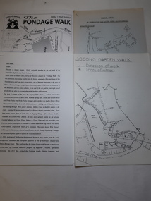
Papers - Mt Beauty Pondage Walk
The Mt Beauty area is picturesque during each of the seasons and therefore an attraction for tourists. During the 1980s and 1990s the Pondage Walk was popular as visitors were able to borrow a tape recording and stop along the way listening to the history of the area.After the completion of the Kiewa Hydro Electric Scheme Mt Beauty became a tourist destination. The walks are popular and vary in length, difficulty and duration. Papers describing walks in the Mt Beauty area including the Mt Beauty Pondage Walk. Includes maps of the walks.mt beauty pondage walk, tourism -
 Kiewa Valley Historical Society
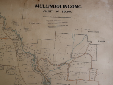
Parish Map - Mullindolingong, County of Bogong
The Department of Lands regularly updated the occupiers with leases or licences of the land.The names of the early settlers of the Kiewa Valley occupying land by lease or licence are shown. Many of these familie's descendants still live in the Kiewa Valley.Government (Lands Department?) cloth map showing the leases or licenses of occupiers of the land in the valley. The Kiewa River is shown in blue and roads in yellow. There is no date on the map.parish of mullindolingong map, settlers of the kiewa valley -
 Kiewa Valley Historical Society
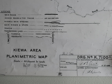
Map - Kiewa Area Planimetric Map
Planimetric maps are two-dimensional representations of the Earth's surface, showing the location and spatial arrangement of features such as roads, buildings, and bodies of water.A very clear map showing the Kiewa Hydro Electric Scheme in two dimensions to include the construction done by the SECV.Black and white Map of the Kiewa Area from Mt Beauty to the High Plains covering the Kiewa Hydro Electric Scheme and surrounds. Drawn on 11th May 1966kiewa hydro electric scheme 1966 -
 Kiewa Valley Historical Society
Map of the Ovens and Murray District of Victoria
The map features Beechworth and its history.This map features the north-east and in particular, Beechworth where residents of the Kiewa Valley may have shopped or visited for appointments.Black and white map with references to roads and gold. The centre of the map is Beechworth and in the bottom left side of the map is the heading Beechworth with 12 lines of print of information regarding Beechworth. The Kiewa Valley is not identified.beechworth -
 Kiewa Valley Historical Society
Maps - Kiewa Valley Parish Maps x3 and Kiewa Area Planimetric Map x1
Planimetric maps are 2 dimensional representations of the Earth's surface, showing the location and spatial arrangement of features such as roads, buildings, and bodies of water. The parish maps show the occupiers with leases or licences of the land. These are updated by the Department of Lands regularly. The names of early settlers of the Kiewa Valley occupying land by lease or licence are shown. Many of these familie's descendants still live in the Kiewa Valley.1. Kiewa Area Planimetric Map (photo) 2. Wermatong, County of Bogong Parish Map 3. Mulllindolingong, County of Bogong Parish Map 4. Mullagong, County of Bogong Parish Map All black and white kiewa valley. parish maps. land owners -
 Kiewa Valley Historical Society
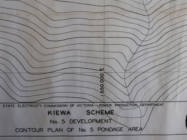
Plans - Kiewa Works Area and Environs
State Electricity Commission of Victoria constructed the Kiewa Hydro Electric Scheme from the late 1940s to 1961. These plans were used during the construction.Plans and Maps were used during the construction of the Kiewa Hydro Electric SchemeTransparent with blue tinge plans/maps created by the SECV during the construction of the Kiewa Hydro Electric Scheme. 1. Kiewa Scheme No 5 Development Contour Plan of No 5 Pondage Area 2. Mt Beauty Township 3. Kiewa Scheme No 1 Development - McKay Creek Area, Construction Layout 4. Kiewa Works and Environs 5. North Eastern Victoria and Adjoining Snowy Mountains Regionsecv, kiewa hydro electric scheme plans -
 Kiewa Valley Historical Society
Maps 3D - National Parks
Used by the employees of National Parks. The maps show the topography and contours in 3D when used with the stereoscope KVHS 0743. This enables the photographed area to be compared to previous photos and enables the planning of construction of eg. new roads etc. Digital information is now available.These photographs give the topography and contours of vast local areas eg. Mt Feathertop and Tawonga township.when used with a stereoscope. Black and white large aerial photos of the Bogong High Plains area. 14 to 20 of them all on thick paper and the same size as the brown wooden box which holds them. The box hasn't got a lid at the top.Identified and catalogued by National Parksmaps showing topography, national parks, stereoscope -
 Kiewa Valley Historical Society
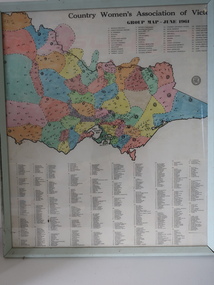
Framed Map - CWA- Tawonga
CWA of Victoria was a popular widely known organisation throughout Australia. The CWA aimed to improve health welfare, and education for women and children living in the country.Each town / area in the Kiewa Valley had an active CWA. The Tawonga branch commenced in Feb. 1946 and often combined activities with other branches of the Kiewa Valley.Country Women's Association of Victoria Group Map, June 1961. each area is colored ad each wit a letter of the alphabet. each group has a number and is listed. eg. blue, 'N' and "Tawonga 14' country women's association, map of cwa groups, tawonga cwa -
 Falls Creek Historical Society
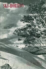
Journal - Ski-Horizon Vol. 2 No 10
Ski-Horizon is the official journal of the Federation of Victorian Ski Clubs which began publication in 1949. The were 26 original member clubs which included Albury Ski Club, Bogong Ski Club, Myrtleford Ski Club, Tallangatta and District Ski Club and Wangaratta Ski Club. Two pioneers of Falls Creek, Tom Mitchell, M.L.A., and Martin Romuld were Vice-Presidents of the Federation.This Journal is significant because it documents the early development of skiing in Victoria.The journal features stories and events chronicling developments in Victoria and internationally. Items related to the Falls Creek Area in this publication include:- Page 2: Albury Ski Club is set for a positive year. Present membership of the club is 130 and officials. recently elected are: -President, Mr. Fred Griffith; Vice-President and Booking Officer, Bob Howe; Secretary. Nell Newton; Asst. Sec., Angela Bowler; Treasurer. Sam Roxburgh; Social, Bruce Colquhoun: Trips, June Watson; Bus, Len Egan; Building. John Perger; Equipment, Peter Hadow. Page 3 Toni St. Elmo is planning the monster party the Bogong Ski Club will give at their Falls Creek Lodge on 4th August to the visiting N.Z. team. Page 8 - 9 Article - The Old Order Passes on the Bogong High Plains - an extensive response to the State Development Committee's Report "The Alpine Regions of Victoria; Skiing and Tourist Resorts" and suggestions for the construction of roads, ski tows and other facilities. A sketch map of Falls Creek Village is included.ski history victoria, federation of victorian ski clubs, development of falls creek -
 Falls Creek Historical Society
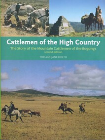
Book - Cattlemen of the High Country, Tor and Jane Holth, 2008
A history of the cattlemen of the Bogongs in the Victorian Alps, including their bushcraft, yarns, hut construction, dog and horse training. It looks at the issue of fire and cattle grazing and the struggle of the mountain cattlemen to retain their leases after the bushfires of 2003. This publication provides an enduring record of a special group of Australian pioneers whose lives and qualities of endurance have become part of Australian folklore.Subtitled "The story of the mountain cattlemen of the Bogongs", this publication of 248 pages includes illustrations, photos, portraits, an index and maps on the end papers. The original edition was published in 1980 A history of the cattlemen of the Bogongs in the Victorian Alps, including their bushcraft, yarns, hut construction, dog and horse training. It looks at the issue of fire and cattle grazing and the struggle of the mountain cattlemen to retain their leases after the bushfires of 2003. This publication provides an enduring record of a special group of Australian pioneers whose lives and qualities of endurance have become part of Australian folklore.bogong high plains, cattlemen of the high plains, bogong high plains history -
 Falls Creek Historical Society
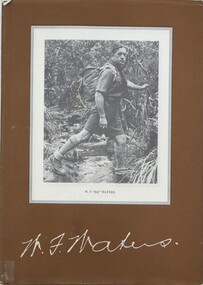
Book - W.F. Waters - A Biography - A Man of the Mountains, Harry Stephenson, 1982
A biography of William Francis Waters which outlines his earlier life and sporting success. It details his exploits in hiking and skiing, including being member of the first party to ski across the Bogong High Plains. Becoming a Rover Scout in 1928, his contribution to the scouting movement led to the award of the Silver Wolf, the highest scouting honour in 1961.A book of 96 pages including maps, illustrations, facsimiles and indexnon-fictionA biography of William Francis Waters which outlines his earlier life and sporting success. It details his exploits in hiking and skiing, including being member of the first party to ski across the Bogong High Plains. Becoming a Rover Scout in 1928, his contribution to the scouting movement led to the award of the Silver Wolf, the highest scouting honour in 1961.william francis waters, hiking victoria, scouting victoria -
 Falls Creek Historical Society
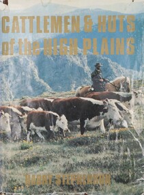
Book - Cattlemen & Huts of the High Plains, Harry Stephenson, 1980
This book records the development of Victoria's alpine regions by the pioneer cattlemen. They came from the Monaro in the 1830s to reach the Plains of Omeo while others advanced up the Murray tributaries to discover the Bogong High Plains in the 1830s and the Gippslanders moved their herds to Alpine pastures in the 1860s. The cattlemen, the snow plain pastures, the mountain scene and the bush huts are described and illustrated in this volume. It records an era in Australia whose story is becoming lost.This volume of 350 pages includes 34 maps, 326 illustrations and diagrams. It has a brown cloth with white lettering and a pictorial jacket featuring cattlemen on the High Plains. It includes an index and bibliography. The front page has an inscription which indicates it had been given to Ore Frueauf of Falls Creek.non-fictionThis book records the development of Victoria's alpine regions by the pioneer cattlemen. They came from the Monaro in the 1830s to reach the Plains of Omeo while others advanced up the Murray tributaries to discover the Bogong High Plains in the 1830s and the Gippslanders moved their herds to Alpine pastures in the 1860s. The cattlemen, the snow plain pastures, the mountain scene and the bush huts are described and illustrated in this volume. It records an era in Australia whose story is becoming lost.victorian high country, mountain cattlemen, victorian high plains