Showing 191 items
matching border post
-
 Frankston RSL Sub Branch
Souvenir, Cloth
Dark blue coloured embroidered satin like cloth with a white satin border on all four sides. Embroidered with the British flag, the British Military Police badge, the British Commonwealth Occupation Forces badge, and a scene depicting Mount Fuji and cherry blossom in thread of various colours. There is also an embroidered inscription. This rectangular cloth is a souvenir of the post World War 2 occupation of Japan and is dated 1947.The embroidered inscription is "To My Darling Mother From Peter Japan 1947" -
 Flagstaff Hill Maritime Museum and Village
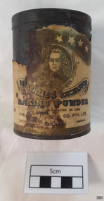
Container - Tin, McKenzies Foods, circa 1930s
This tin once contained McKenzie’s baking powder, a cooking ingredient. It was donated with other similar tins that were used by the donor’s mother who was married in 1932. It those times in Australia all manner of household items, including food and drink, were sold by hawkers (salesmen) who travelled from door to door in both suburban and rural areas. The donor remembered the bicarb soda tin on her mother’s pantry shelf. The McKenzie’s Baking Powder label adds the information that the ingredients were “Prepared with Aerophos, Regd. Trade Mark, the finest raising ingredient. A product of Albright & Wilson, Australia Pty. Ltd.” It also says that it “Excels all others in use”. The Australian family business, McKenzie’s Foods, began in Melbourne in 1852 and continues today, now run be the fifth generation of descendants from the original owners. Its baking and cookery products are well recognised by Australians. This tin originates in the early 1900s from an Australian company that is now managed by fifth generation descendants of the original family after its inception in 1852. The tin increases in significance for its use as a recognised object found in many Australian kitchens since early days. It gives a snapshot into domestic life and social norms of the pre and post war period in Melbourne The tin is significant for its association with a local family in the 1930s for the preparation of family meals. Tin container, cylindrical, with cream paper label with gold highlights, motif and text. Used for selling McKenzie’s Excelsior baking powder. Container has push-on lid. Quantity of 1/2 LB. NETT. Made in Australia by Jas. F. McKenzie & Co. Pty Ltd. Text includes “JAS. F. McKENZIE & CO. PTY. LTD. / AUSTRALIA“ “McKENZIE’S EXCELSIOR / BAKING POWDER”. Motif: man’s portrait within oval frame with wheat sheaf border, placed below figures of sun, moon and stars. Information and instructions. flagstaff hill asset, baking powder tin, container, flagstaff hill museum, kitchen item, cookery, baking, grocery, mckenzie, rising agent, food container, flagstaff hill, warrnambool, shipwrecked coast, flagstaff hill maritime museum, maritime museum, shipwreck coast, flagstaff hill maritime village, great ocean road, tin, cooking ingredient, baking powder, mckenqie -
 Flagstaff Hill Maritime Museum and Village
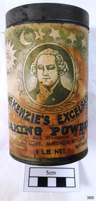
Container - Tin, McKenzies Foods, circa 1930s
This tin once contained McKenzie’s baking powder, a cooking ingredient. It was donated with other similar tins that were used by the donor’s mother who was married in 1932. It those times in Australia all manner of household items, including food and drink, were sold by hawkers (salesmen) who travelled from door to door in both suburban and rural areas. The donor remembered the bicarb soda tin on her mother’s pantry shelf. The McKenzie’s Baking Powder label adds the information that the ingredients were “Prepared with Aerophos, Regd. Trade Mark, the finest raising ingredient. A product of Albright & Wilson, Australia Pty. Ltd.” It also says that it “Excels all others in use”. The company began in Melbourne in 1852 and continues today, now run be the fifth generation of descendants from the original owners. This tin originates in the early 1900s from an Australian company that is now managed by fifth generation descendants of the original family after its inception in 1852. The tin increases in significance for its use as a recognised object found in many Australian kitchens since early days. It gives a snapshot into domestic life and social norms of the pre and post war period in Melbourne The tin is significant for its association with a local family in the 1930s for the preparation of family meals. Tin container, cylindrical, with cream and green paper label with gold highlights, motif and text. Used for selling McKenzie’s Excelsior baking powder. Container has push-on lid. Quantity of 1LB. NET. Made in Australia by McKenzie Ltd.Text includes “CLIFFORD LOVE, McKENZIE PTY. LTD.” “McKENZIE’S EXCELSIOR / BAKING POWDER”. Motif: man’s portrait within oval frame with wheat sheaf border, placed below figures of sun, moon and stars. Information and instructions. flagstaff hill asset, baking powder tin, container, flagstaff hill museum, kitchen item, cooking ingredients, flagstaff hill, warrnambool, shipwrecked coast, flagstaff hill maritime museum, maritime museum, shipwreck coast, flagstaff hill maritime village, great ocean road, tin, cooking ingredient, food container, grocery, cookery, rising agent, baking powder, mckenzie, mckenzie foods -
Mission to Seafarers Victoria
Letter - Correspondence, 08/12/1950
The writer is replying to a letter from Allan and contains news of fellow seafarers.Quinn CollectionThree page letter written on three sheets of thin, unlined, buff-coloured paper (0853.1a-3a). It is headed Salinas and dated 08/12/50. The air-mail envelope (0853.b) is bordered with red and blue alternating diagonal stripes. It is addressed to Mr Allan Quinn, Liddesdale Avenue, Frankston, Victoria, Australia. The return address, written in the top left hand corner, is Peer Rasmussen, 330 1/2 Central Avenue, Salinas, California, USA. The stamps and part of the post-mark have been torn from the envelope. Letter commences "Hello my friend, ....." and concludes ..."'your sincere friend, Peer."letters-from-abroad, peer rasmussen, salinas -
Mission to Seafarers Victoria
Letter - Correspondence, Allan Charles Quinn, 14/12/1950
Allan writes that he has left the ship M S Mongabarra in Sweden and traveled by train to Oslo where he will stay for about 14 days before travelling to London. He has sent "...a very big carton, a smaller one - a trunk and coffee table back to Australia."Quinn CollectionA single sheet of very thin paper folded in half, book form, with writing on the first and third pages only (0854.a). Written in green ink it is headed Oslo and dated 14/12/50. The air-mail envelope (0854.b) is bordered with alternating purple and yellow diagonal stripes. There are three Norwegian stamps, one green and two purple, in the right upper corner. It is post-marked Oslo and addressed Mrs K Hayes, 14 Fitzroy Street, St. Kilda, Victoria, Australia. The letter is from Allan to his mother. letters-from-abroad, allan quinn, oslo -
 Mission to Seafarers Victoria
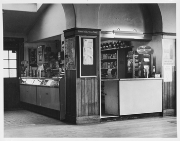
Photograph - Photograph, Black and white, Melbourne Harbour Trust, c. 1963
The canteen is part of the Mission to Seafarers building that has catered to visiting seafarers since 1917. The canteen is operated by the Flying Angel Club, which offered services to seafarers including food, drink and souvenirs from the canteen and events held in the main hall which invloved the use of the canteen. The Ladies Harbor Lights Guild also used the canteen facilities for functions and fundraisers held at the Mission to Seafarers. One of the flyer in Chinese helps dating the photograph between 1963-66 when Padre Wong was chaplain at the Mission.Historical record of the Mission to Seafarers canteen post-1963. This is an example of the contemporaneous use of the canteen as primarily a supply shop and in a comparative fashion reveals some of the overall changes at the Mission.A white-bordered, black and white photograph of the Mission to Seafarers Canteen. From the left hand side of the photograph the image portrays an external doorway with six glass windows, emitting light from behind. This leads to the dipslay cabinet and bench of the canteen which is reflecting light from the windowed door. Central to the image is a pillar which is three-quarters wood paling starting from the floor, of which a map is displayed on one edge and a notice board on the remaining visible edge of the pillar. A bench is visible to the right side of the pillar and the far right side of the photograph, posters are hung on the wall. Purple stamp on central back of photograph. "Melbourne Harbor/Trust Photograph/Negative No......." photograph, canteen, tab, koalas, blackboard, archway, pennant, licensed-to-sell-postage-stamps, mission to seamen, mission to seafarers, melbourne, flying angel club, map, bar, milkshake machine, display case, fluorescent light, notice board, wains coting, postcards, milkshake, beverage, plastichrome, matches, razors, gillette, straw, melbourne harbour trust, melbourne harbor trust, donation tin, lighthouse -
 Mission to Seafarers Victoria
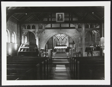
Photograph - Photograph, Black and white, Memorial Chapel of Peter
The St Peter Chapel opened in 1917. Funding came primarily from the Ladies Harbour Lights Guild. The artwork "And the Lord turned and looked upon Peter" was donated by Mr R. Stewart Murray in 1940. The procession cross was donated by the Ballarat Branch of the Harbour Lights Guild in 1958 helping dating the photograph to post 1958.St Peter the Mariner's Chapel is ..... by the relationship with the Anglican Church. Although Black and white photograph with a white border, of the interior of Saint Peter the Mariner's Chapel. Central is the aisle with pews on either side. Midground and on the left side is the pulpit and an altar in the background. melbourne, mission-to-seafarers, altar, pulpit, pews, choir-stalls, reverend w.f. haire, walter richmond butler, jesus, st peter chapel, lectern, hymn board -
Glenelg Shire Council Cultural Collection
Postcard, Methodist Church, Casterton, Vic, c. 1960
Sourced from Casterton Town Hall (former Shire of Glenelg)Black and white postcard, METHODIST CHURCH, CASTERTON, white border around image. No. 3 in a series by 'Latimers'Front: 'Latimers METHODIST CHURCH, CASTERTON VIC NO.3 Back: 'POST CARD' -
Glenelg Shire Council Cultural Collection
Postcard - Postcard - Casterton, Victoria, 1960s
Sourced from Casterton Town Hall (former Shire of Glenelg)Postcard, black and white, white border, view of Casterton High School and front lawnsFront: 'HIGH SCHOOL 4108, Casterton, VIC.' in bottom border Back: 'POSTCARD PRINTED IN AUSTRALIA' Blue biro line, arrowed each end; drawn across width of card. 3" written above line. Post Card Stamptourism, casterton -
 Halls Gap & Grampians Historical Society
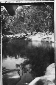
Postcard - B/W
The location of the photo was in the vicinity of Myrtlebank, upper Halls Gap. The pool was called "Mirror Pool"Photo shows large pool of water bordered by the sandy banks of a creek (Fyans Creek).Hand written "A Happy New Year to all PS this is close to where we live Typed Post card, correspondence, Address only Kodak, Australia. 'Mirror Pool" written in ink in top, left border of photo.scenery -
 Kiewa Valley Historical Society
Dress - Bridesmaid's Dress
Bridesmaid's dress worn at Margaret Rose Vyner and Ian McKendrick's wedding on 11th January 1958The McKendrick family came to Mt Beauty very early in the Kiewa Hydro Electric Scheme (KHES) days. Their son, Ian, worked in the Mt Beauty Post Office for 40+years. Vyner family also long time employees of the SECV on the KHES. They were residents of Mt Beauty. Margaret was a nurse at the Tawonga District Hospital at the Tawonga site . White sleeveless dress with a taffeta underskirt with 2 tulle gored over skirts. The bodice is tulle over taffeta with fitted bodice, scooped neckline decorated border of lace and diamantes with a side zip.Maker's Tag: Milady's Robesbridesmaid's dress, vyner family, mckendrick family -
 Victoria Police Museum
Police Stations (Apsley)
Apsley is a small town in Victoria, Australia. It is on the Wimmera Highway, in the Shire of West Wimmera, 420 kilometres north-west of Melbourne, and 7 kilometres east of the South Australian border. Apsley Police Station opened on 29th November 1884 and was originally located in Wallace Street. It was staffed by one Foot Constable (motor cycle). The building was described, in 1930, as a four-roomed dwelling with an iron roof, set on a quarter of an acre of land. There was a bathroom, a WC, wash-house and a garage. An office adjoined the house and there was also a lockup. The station moved several times until the mid 1960s when a timber residence was moved onto land adjacent to the Post Office. The building is believed to have been transported from the Stawell area. Apsley is one of a handful of one-man police stations in Victoria and its current location, including residence, is at 19 Splatt Street. Apsley was in the Western District when it opened, then in "L" (Wimmera) District from January 1948 and "M" (Highlands/Wimmera) District from March 1990. 4 black & white photos, 1965 3 colour photos, 1987police stations; apsley police station -
 Warrnambool and District Historical Society Inc.
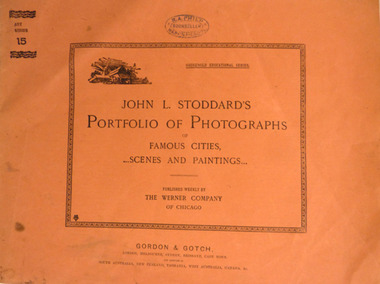
Booklet, Printed in USA, Portfolio of Photographs of Famous Cities, 1893
In a time when travel to distant parts of the world were difficult. Magazines such as these, offered people the opportunity to see the sights of the World. The link to Warrnambool, with this publication is the R.A. Philp stamp on the front cover. R. A. Philp was a bookseller who operated his business in Timor St opposite the Post Office.Soft card, light brown cover, with black text. Inside black rectangular border is the title “John L. Stoddard’s Portfolio of Photographs of Famous Cities scenes and Paintings.” In smaller text “Published weekly by the Werner Company of Chicago. ”Art Series 10 on top left corner. Inside are 16 pages of Black and white photos of scenes from around the world, with explanatory text underneath each photo. Back cover has list of contents of Series 11. Purple stamp, R.A. Philp, bookseller Warrnambool, in centre top. Gordon and Gotch, London, Melbourne, Sydney, Brisbane, Capetown.warrnambool, philp, booksellers., stoddard -
 Flagstaff Hill Maritime Museum and Village
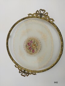
Domestic object - Dressing table tray, Mid 20th century
Dressing tables (also known as Vanity Tables in the U.S.A.) have been around since the beginning of the seventeenth century, however it wasn't until the early to mid 20th century that they began to be found in the homes of the middle class and they were often a matching part of a bedroom suite. Dressing tables often featured a variety of objects such as combs, brushes, hand mirrors, perfume bottles, cosmetics, nail buffers, ring holders, jewellery and trinket boxes and trays. The origins of this tray are unknown however its design is reminiscent of trays (and Dressing Table Sets) produced by two English firms in the mid 20th century - "Delina" and "Regent of London". A paper (written by the Warwickshire Industrial Archeology Society) notes that the products items produced by "Regent of London" in the 1940's "satisfied a demand for previously unattainable items, offered to the general public aching for change after wartime privations, post war austerity and years of having to 'make do and mend'." This tray is composed of several decorative elements and materials. The metal border is gilt brass with two filigree bow handles, the main part of the tray is two pieces of circular glass and the encased doily is a mix of embroidered net and petit point. It was suggested in the paper written by the Warwickshire Industrial Archeological Society that the different pieces would have probably been produced elsewhere and brought to the factory to be assembled into the finished product. This vanity or dressing table tray is significant as it is a rare example of an accessory available to and used by women in the mid 20th century. It is also significant as an example of an everyday household item which would have been a valued possession and was made in a style that reflected the importance placed on it to be decorative as well as functional.Round footed dressing table tray with a gilt brass border, filigree bow handles and an embroidered net and petit point doily encased in glass. The gilt border is decorated with a stylized leaf design on the side and a floral design on the top. The petit point embroidery in the center is of five flowers in pink, mauve and yellow surrounded by buds and leaves.vanity tray, dressing table tray, glass tray, gilt brass, petit point, embroidery, net embroidery, doily, filigree, brass tray, flagstaff hill maritime village, shipwreck coast, flagstaff hill, warrnambool, flagstaff hill museum and village, domestic object, dressing table -
 Flagstaff Hill Maritime Museum and Village
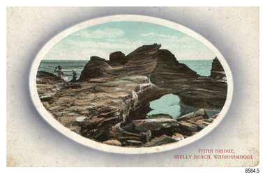
Postcard - Scenic, Warrnambool, Titan Bridge, Shelly Beach, Warrnambool, 1902-1929
The nine postcards in this set were donated together and date to the early 1900s. All but one postcard in this set shows images of Warrnambool, in the Western District of Victoria; the other has a London image. The postcards were all printed in Great Britain according to that country’s postal regulations. The fronts of all cards have titles printed in red. Most of the images on the cards are attributed to photographer Joseph Jordan and belong to the Jordan Series. The back of these cards has an outline for a postage stamp, a vertical dividing line and a heading on each side of the line to separate the Correspondence from the Address. Postcards or ‘correspondence cards’ appeared in Britain in 1894. They were plain cards with a space for the message on one side and an address on the other; regulations didn’t allow anything but the address to be written on the ‘address’ side. In 1902 the British regulations then allowed a picture to be printed on the front and the address on the back, so messages had to be written on the picture side. Soon, the regulations changed and the back was divided for a message and the address. Titan Bridge, Warrnambool – The name Titan Bridge is likely to be a reference to the huge Titan crane that was used in the construction of the Breakwater in the late 19th century. Shelly Beach is a popular swimming area with the added attraction of rock pools to investigate and rock formations to climb. Joseph Jordan - Joseph Jordan was born in 1841 in Leicester England. When he was 16 he joined the 7th Queen's Own Hussars and was sent to India at the outbreak of the mutiny. He took part in the relief of Lucknow and remained in India for eleven years. It was during this time that he became interested in photography. He was posted to New Zealand and later came to Victoria, becoming a sergeant major of the Mounted Rifles. In the mid-1880s he came to the Western district where he was responsible for establishing units of the Mounted Rifles in various country towns such as Dunkeld, Mortlake, Panmure, Bushfield, Koroit etc. He resigned from the army in 1889 and set up a professional photography studio in Liebig Street, Warrnambool. He became very well known in the Western District for family photographs, official photographs of local councillors and groups as well as views of local scenery. In 1891 he photographed the wrecked barque ‘Fiji’ at ‘Wrecks Beach’ near Princetown. His business was taken over by his son Arthur around 1917. Joseph was a keen rifle shot and in 1924 he donated the "Jordan Shield" as a prize to the Victorian Rifle Association. He was made a "Life Honorary Member" of the Warrnambool Returned Soldiers League and in 1933 he was recognised as being the oldest living soldier in Victoria. Joseph died in 1935 aged 95.The image of the Titan Bridge rock formation with figures on it suggests that the location was a popular place to visit. It captures a time when the rock formation was publically accessible. The choice of subject for this postcard indicates the popularity of Warrnambool's natural environment as a tourist attraction at a time when ships called coastal traders brought passengers and cargo to the Port of Warrnambool from ports along Victoria's southwest coast. Joseph Jordan is a significant figure in Warrnambool history as he helped to establish early units of the Mounted Rifles (G Company) in local towns during the late 1880's and later, photographed local scenes, groups and citizens of early Warrnambool.Postcard, one of nine, landscape orientation, coloured print within an oval border and mauve-toned shading. The cameo image shows two figures, one seated and one standing, beside the sea on a rough rock beside a rock formation resembling a bridge. There is no correspondence written on the card. The back has inscriptions and outlines for a postage stamp. Jordan Series, printed in Great Britain.Front, in red: “TITAN BRIDGE / SHELLY BEACH, NEAR WARRNAMBOOL” Back in black: “Jordan Series” “POST CARD” “PRINTED IN GREAT BRITAIN” “For correspondence” “The Address only to be written here”flagstaff hill maritime museum, flagstaff hill maritime village, flagstaff hill maritime museum and village, maritime museum, warrnambool, great ocean road, warrnambool and district, warrnambool scenes, local scenes, views of warrnambool, joseph jordan, jordan series, jordan photography, postcard, souvenir, correspondence, cameo postcard, landscape, shelly beach, titan bridge, titan, rock formation -
 Flagstaff Hill Maritime Museum and Village
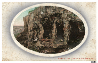
Postcard - Scenic, Warrnambool, Pillar Caves, near Warrnambool, 1902-1929
The nine postcards in this set were donated together and date to the early 1900s. All but one postcard in this set shows images of Warrnambool, in the Western District of Victoria; the other has a London image. The postcards were all printed in Great Britain according to that country’s postal regulations. The fronts of all cards have titles printed in red. Most of the images on the cards are attributed to photographer Joseph Jordan and belong to the Jordan Series. The back of these cards has an outline for a postage stamp, a vertical dividing line and a heading on each side of the line to separate the Correspondence from the Address. Postcards or ‘correspondence cards’ appeared in Britain in 1894. They were plain cards with a space for the message on one side and an address on the other; regulations didn’t allow anything but the address to be written on the ‘address’ side. In 1902 the British regulations then allowed a picture to be printed on the front and the address on the back, so messages had to be written on the picture side. Soon, the regulations changed and the back was divided for a message and the address. Pliiar Caves, near Warrnambool – The formation at the front of the cave resembles the pillars of a porch, giving the cave its name. Local social media discussion locates the caves near Lake Gillear, east of Warrnambool. The area was popular with young lads as a place to explore and to go rabbiting. The caves in this area are home to colonies of bats and have been a source of bat feces or bat guano, which is an enriching additive to soil. The 19th century sailing ships in the Nitrogen or Guano trade collected large quantities of guano from caves and popular bird nesting locations to sell as a rich fertiliser, due to its high nitrogen and phosphorus properties. Joseph Jordan - Joseph Jordan was born in 1841 in Leicester England. When he was 16 he joined the 7th Queen's Own Hussars and was sent to India at the outbreak of the mutiny. He took part in the relief of Lucknow and remained in India for eleven years. It was during this time that he became interested in photography. He was posted to New Zealand and later came to Victoria, becoming a sergeant major of the Mounted Rifles. In the mid-1880s he came to the Western district where he was responsible for establishing units of the Mounted Rifles in various country towns such as Dunkeld, Mortlake, Panmure, Bushfield, Koroit etc. He resigned from the army in 1889 and set up a professional photography studio in Liebig Street, Warrnambool. He became very well known in the Western District for family photographs, official photographs of local councillors and groups as well as views of local scenery. In 1891 he photographed the wrecked barque ‘Fiji’ at ‘Wrecks Beach’ near Princetown. His business was taken over by his son Arthur around 1917. Joseph was a keen rifle shot and in 1924 he donated the "Jordan Shield" as a prize to the Victorian Rifle Association. He was made a "Life Honorary Member" of the Warrnambool Returned Soldiers League and in 1933 he was recognised as being the oldest living soldier in Victoria. Joseph died in 1935 aged 95.The image of the Pillar Caves rock formation with figures on it suggests that the location was a popular place to visit. The choice of subject for this postcard indicates the popularity of Warrnambool's natural environment as a tourist attraction at a time when ships called coastal traders brought passengers and cargo to the Port of Warrnambool from ports along Victoria's southwest coast. The presence of bats in local caves also connects the postcard to the 19th century Nitro Trade and Guano Trade, when bat guano was collected and sold for plant fertiliser around the world. Joseph Jordan is a significant figure in Warrnambool history as he helped to establish early units of the Mounted Rifles (G Company) in local towns during the late 1880's and later, photographed local scenes, groups and citizens of early Warrnambool.Postcard, one of nine, landscape orientation, coloured print within an oval border and mauve-toned shading. The cameo image shows figures on the high, grass-topped cliff, one between the likeness of pillars in the cave entry, and others walking on the rocks nearby. The background below is rough ground. There is no correspondence written on the card. The back has inscriptions and outlines for a postage stamp. Jordan Series, printed in Great Britain.Front, in red: “PILLAR CAVES, NEAR WARRNAMBOOL” Back in black: “Jordan Series” “POST CARD” “PRINTED IN GREAT BRITAIN” “For correspondence” “The Address only to be written here”flagstaff hill maritime museum, flagstaff hill maritime village, flagstaff hill maritime museum and village, maritime museum, warrnambool, great ocean road, warrnambool and district, warrnambool scenes, local scenes, views of warrnambool, joseph jordan, jordan series, jordan photography, postcard, souvenir, correspondence, cameo postcard, landscape, rock formation, pillar caves, pillars cave, lake gillear, rebbiting, bats, guano, nitro trade, fertilizers -
 Flagstaff Hill Maritime Museum and Village
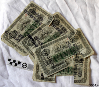
Currency - Banknote set, Bank of Australasia, 1899-1903
This set of banknotes was issued by the Bank of Australasia's Head Office in Sydney, New South Wales. Two banknotes are dated before the Federation of Australia on 1st January 1901 and two are dated just two years after Federation. Each of the banknotes in this set has a rectangular piece cut from it. This indicates that the banknote was cancelled when the note was exchanged for Australian dollars after Decimal Currency was introduced on 14th February 1966. The Bank of Australasia was established under the Royal Charter of England. It first came to Australia in 1835, opening in Sydney. The Bank of Australasia was the first bank in Warrnambool. It was established in 1854 and operated from leased buildings in Merri Street then Timor Street. The bank opened its own building on May 21, 1860, on the north-east corner of Timor and Kepler Streets. In that year, the Acting Superintendent of the Bank of Australasia in Sydney was David Charters McArthur. He went on to become the Superintendent 1867-1876. In 1951 the Bank of Australasia amalgamated with the Union Bank to form the Australia and New Zealand Bank, now known as the ANZ. Then in 1970 the ANZ merged with both the ES&A and the London Bank of Australia to form the ANZ Banking Group Limited. The ANZ Banking Group Ltd kindly donated a variety of historic items from the Bank of Australasia. This set of banknotes has historical significance as it was issued by the Bank of Australasia. The Bank of Australasia was the first bank in Warrnambool, established in 1854. The bank continued to operate until its merger in 1951 when it became the ANZ Bank, which is still in operation today. The Bank was an integral part of the establishment and growth of commerce in Colonial Warrnambool and throughout Australia. The banknotes also have a significant place in Australia’s history as two notes are just prior to the Federation of Australia and two notes just after.This banknote set of four notes comprises three (3) £1 one-pound notes and one (1) £5 five-pound note. The notes were published by The Bank of Australasia, Sydney, New South Wales between 1899 and 1903. The denominations of the notes and their round pound-coin symbols are printed in green ink, and the remainder of the printing is in black ink. All notes have a black ink stamp impressed twice on each side. The stamp states that the notes are cancelled. There are handwritten initials in red ink on each note's obverse and text in pencil on their reverse. The reverse of the one-pound notes is unprinted but the five-pound note has a printed decorative border and images with an inscription and shield. The notes have a rectangular cut-out on the lower edge.Serial Numbers, Denominations and Dates: 5054.1 "ONE POUND" "Q50,806" "NEW SOUTH WALES" "1st July 1903" 5054.2 "ONE POUND" "O50 551" "NEW SOUTH WALES" "1st July 1903" 5054.3 "ONE POUND" "O24,385" "NEW SOUTH WALES" "1st July 1899" 5054.4 "FIVE POUND" "A36,191" "NEW SOUTH WALES" "5th February 1900" Stamp "BANK OF AUSTRALASIA / CANCELLED" Handwritten in red [initials] Image on five pound note"(around border) "BANK OF AUSTRALASIA INCORPORATED BY ROYAL CHARTER" and (image on shield) [suspended sheep] in diagonal corners, and [sailing ships] in other diagonal corners, and four stars (or open flowers)" Text in pencil "L24"flagstaff hill, warrnambool, one pound note, bank of australasia, legal tender, £1, banknote, banknotes, flagstaff hill maritime museum & village, shipwreck coast, five poind note, australian currency, shipwrecked coast, flagstaff hill maritime museum, maritime museum, flagstaff hill maritime village, great ocean road, union bank, australia & new zealand bank, anz bank, david charters mcarthur, d c mcarthur, one-pound note, five-pound note, £5, sydney, new south wales, pre-federation, post-federation, currency, set of banknotes -
 Flagstaff Hill Maritime Museum and Village
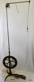
Equipment - Dentist Drill, Late 19th century
The design of this and other similar treadle powered dental engine (or dentist drill) was in common use by dentists from the 1870’s into the 1920's. When electricity became accessible to most communities the electrically powered dental engines began to take over from the treadle power. Over the ages teeth were extracted using picks and scissors and other gouging instruments. Bow drills, hand drills and even a "bur thimble" drill were later used to prepare cavities for filling. Some drills were made bendable by attaching flexible shanks between the metal bur and the handle, giving access to the teeth at the back of the mouth. Other mechanical devices were introduced along the way, such as clockwork drills, but they were hard to handle and inefficient. Over the centuries “dentistry has been performed by priests, monks and other healers. This was followed by barbers; the barber’s chair may well have been the precursor to the dental chair. “(SA Medical Heritage Society Inc.) In 1871 James Morrison patented the first commercially manufactured 'foot treadle dental engine', the first practica dental engine although others had been introduced as early as 1790 (by John Greenwood). Handmade steel burs or drills were introduced for dental handpieces, taking advantage of the significant increase in the speed of the drill. In 1891 the first machine-made steel burs were in use. The treadle drill reduced the time to prepare a cavity from hours to less than ten minutes. In 1876 the Samuel S. White Catalogue of Dentist Instruments listed a 12 ½ inch wheel diameter dental engine, with 14 bright steel parts, for sale at US $55 In today’s market, this is the equivalent to US $1200 approx. The specifications of that dental engine are very similar to the this one in our Flagstaff Hill Maritime Village’s collection. It is interesting to note that workings of a similar treadle dentist drill were used and modified to power a treadle spinning wheel of one of the volunteer spinners at Flagstaff Hill Maritime Village. The foot treadle dental engine was a milestone in dental history. “Historic importance of treadle powered machines; they made use of human power in an optimal way” (Lowtech Magazine “Short history of early pedal powered machines”) The invention of a machine to speed up the process of excavation of a tooth lead to the invention of new burs and drills for the handpieces, improving speed and the surgical process of dentistry. They were the fore-runner of today’s electrically powered dental engines. This treadle-powered dentist drill, or dentist engine, is made of iron and steel and provides power for a mechanical dental handpiece that would be fitted with a dental tool. On the foot is painted lettering naming it "The Brentfield" and there is a fine line of light coloured paint creating a border around the name. The paint under the lettering is peeling off. The drill has a Y-shaped, three footed cast iron base, one foot being longer than the other two. A vertical frame is joined into the centre of the base, holding an axle that has a driving-wheel (or flywheel) and connecting to a crank. A slender, shoulder height post, made from adjustable telescoping pipes, joins into the top of this frame. On the post just above the frame is a short metal, horizontal bar (to hold the hand-piece when it is not in use). A narrow tubular arm is attached to the top of the stand at a right angle and can move up, down and around. There is a pulley each side of the joint of the arm and a short way along the arm is fitted a short metal pipe. A little further along the arm a frayed-ended cord hangs down from a hole. At the end of the arm is another pulley and a joint from which hangs a long, thin metal pipe with two pulleys and a fitting on the end. A treadle, or foot pedal, is joined to the long foot of the base, and joined at the toe to the crank that turns the driving-wheel. The metal driving-wheel has a wide rim. Touching the inside of the rim are four tubular rings that bulge towards the outside of the driving-wheel, away from the pole, and all meet at the hub of the axle. The axle fits between the inside of the driving-wheel and the frame then passes through the frame and is attached on the other side. The driving-wheel has a groove around which a belt would sit. The belt would also fit around a pulley on the arm, at the top of the post. The pulley is joined to a rod inside the arm and this spins the drill's hand-piece and dental tool holder. The foot pedal has a cross-hatch pattern on the heel and the ball of the foot has tread lines across it. The end of the toe and the instep areas have cut-out pattern in them. "The ____/ Brentfield / __ DE IN L___" (Made in London) painted on the long foot of the base. Marked on the drill connection is “Richter De Trey, Germany”flagstaff hill, warrnambool, shipwrecked coast, flagstaff hill maritime museum, maritime museum, shipwreck coast, flagstaff hill maritime village, great ocean road, dentist, teeth, dental drill, dental engine, treadle drill, foot powered drill, treadle engine, orthodontics, dental surgery, james morrison, the brentfield, richter de trey, german dental fitting, london dental drill -
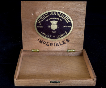 City of Moorabbin Historical Society (Operating the Box Cottage Museum)
Manufactured object, Cigar Box J.Van Maurik c1950, c1950
This is an empty Justus Van Maurik cigar box made c1950 by appointment to the House of Lords, London and the cigars were used by George Reed who was a draftsman in City of Moorabbin c1950. c1700 The Dutch East India Company brought spices from South East Asia and tobacco from the New World to Sumatra and Java in Indonesia. 1794 Justus van Maurik Senior established a tobacco factory in the centre of Amsterdam and his son, Justus van Maurik Junior, spread the company’s fame well beyond the borders of (Holland) Netherlands as he travelled the world successfully promoting the family’s tobacco business.Dutch cigars were popular c1950 in the City of Moorabbin and Justus van Maurik Pty Ltd was a quality producer from Amsterdam , Holland (Netherlands) commencing production c1794. George Reed was a draftsman who lived in City of Moorabbin c1950 A plywood hinged cigar box Lid ; JUSTUS VAN MAURIK / BY APPOINTMENT TO / FAMOUS H T/M L SINCE 1754/ THE / HOUSE OF LORDS / IMPERIALES Inside Lid ; as above cigars, justus van maurik pty ltd., holland, amsterdam, netherlands, dutch east india company, redheads safety matches, safety matches, bryant & may pty ltd, early settlers, moorabbin, bentleigh, cheltenham, tobacco, reed george, draftsman, architect, moorabbin shire, city of moorabbin, post world war 2 estates -
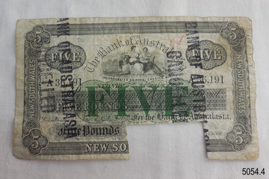 Flagstaff Hill Maritime Museum and Village
Currency - Banknote, Five-pound
This five-pound banknote is one of a set of four banknotes issued by the Bank of Australasia's Head Office in Sydney, New South Wales. Two banknotes are dated before the Federation of Australia on 1st January 1901 and two are dated just two years after Federation. Each of the banknotes in this set has a rectangular piece cut from it. This indicates that the banknote was cancelled when the note was exchanged for Australian dollars after Decimal Currency was introduced on 14th February 1966. The Bank of Australasia was established under the Royal Charter of England. It first came to Australia in 1835, opening in Sydney. The Bank of Australasia was the first bank in Warrnambool. It was established in 1854 and operated from leased buildings in Merri Street then Timor Street. The bank opened its own building on May 21, 1860, on the north-east corner of Timor and Kepler Streets. In that year, the Acting Superintendent of the Bank of Australasia in Sydney was David Charters McArthur. He went on to become the Superintendent 1867-1876. In 1951 the Bank of Australasia amalgamated with the Union Bank to form the Australia and New Zealand Bank, now known as the ANZ. Then in 1970 the ANZ merged with both the ES&A and the London Bank of Australia to form the ANZ Banking Group Limited. The ANZ Banking Group Ltd kindly donated a variety of historic items from the Bank of Australasia. This set of banknotes has historical significance as it was used by the Bank of Australasia, the first bank in Warrnambool. The bank was established in 1854 and continued until its merger, when it became the ANZ Bank in 1951 and is still in operation today. The bank was an integral part of the establishment and growth of commerce in Colonial Warrnambool, Victoria, and Australia. The banknotes also have a significant place in Australia’s history as two notes are just prior to Federation and two notes just after Federation.Five-pound banknote, one of a set of four banknotes published by The Bank of Australasia, Sydney, New South Wales. The obverse of the note is printed in black ink with the denomination and its round pound-coin symbols printed in green ink. The reverse has a decorative border and image with an inscription and shield. A black ink stamp was impressed twice on each side, stating that the note is cancelled. Handwritten red ink text is on the note's obverse and pencil text on the reverse. A unique Serial number is printed twice on the obverse. The banknote has a rectangular cut-out notch on the lower edge. Printed: (Serial Number) "A36,191" "FIVE POUND" "NEW SOUTH WALES" "5th February 1900" Stamp "BANK OF AUSTRALASIA / CANCELLED" Image: (around border) "BANK OF AUSTRALASIA INCORPORATED BY ROYAL CHARTER" and (image on shield) [suspended sheep] in diagonal corners, and [sailing ships] in other diagonal corners, and four stars (or open flowers)" Handwritten in red pen: "undecipherable [initials]" Text in pencil "L24"flagstaff hill, warrnambool, one pound note, bank of australasia, legal tender, £1, banknote, banknotes, flagstaff hill maritime museum & village, shipwreck coast, five poind note, australian currency, shipwrecked coast, flagstaff hill maritime museum, maritime museum, flagstaff hill maritime village, great ocean road, union bank, australia & new zealand bank, anz bank, david charters mcarthur, d c mcarthur, one-pound note, five-pound note, £5, sydney, new south wales, pre-federation, post-federation, currency, banknote set -
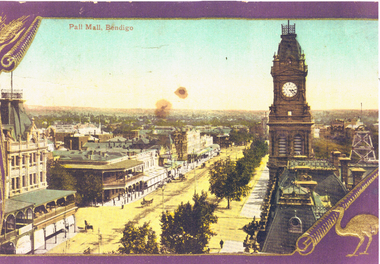 Bendigo Historical Society Inc.
Photograph - LONG GULLY HISTORY GROUP COLLECTION: PALL MALL, BENDIGO
Enlarged photo of a coloured postcard of Pall Mall, Bendigo. The photo shows a tree lined Pall Mall with some horse drawn vehicles and pedestrians. Myers have their name on the veranda and there is a sign with Abbott next to it. On the right side is the Post Office clock tower and behind is the poppet legs of a mine. The photo has a purple and gold border. In the bottom right corner beside a rolled corner is an emu and in the top left corner is a scroll and part of a head of wheat.bendigo, history, long gully history group, the long gully history group - pall mall bendigo, morley johnson's, myers, abbott -
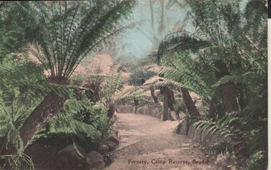 Bendigo Historical Society Inc.
Postcard - ELAINE ROBB COLLECTION: BENDIGO FERNERY
Hand coloured postcard: image shows Fernery, Rosalind Park, Bendigo. In centre of image, gravel pathway bordered by stonework, ferns on either side. On bottom of card: Fernery,Camp Reserve, Bendigo. Possibly late 1890's ? On rear of card: Post card W.T.P. in ornate diamond shape (produced by WT Pater, printers & stationers )W.T.Pater -
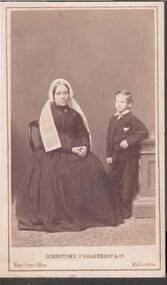 Bendigo Historical Society Inc.
Photograph - PORTRAIT OF A LADY AND A BOY
Small portrait of a lady seated on a chair with a boy standing beside her with his left elbow resting on a cupboard? The lady is wearing a dress with a voluminous skirt and a high buttoning neck with a brooch at the neckline. She is also wearing a cap with two broad long pieces down her shoulders. The boy is wearing a three piece suit. Photographer's name and address printed on the front and back of the photograph. Photo has gold border around it and gold printing on the front.Johnstone, O'Shannessy & Co., 3 Bourke St. East. Next to the Post Office, Melbournephotograph, portrait, lady & child, portrait of a lady and a boy, johnstone o'shannessy & co. -
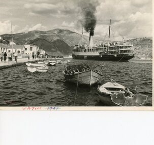 Ithacan Historical Society
Photograph, Angelika ship departing Ithaca, c 1951
Prior to the advent of the ferry service Ithacans who wished to travel to the mainland sailed by ship. The 'Angelika', photographed in Ithaca's port harbour of Vathi, transported most of the post WWII Ithacan migrants to the main Greek port of Piraeus to embark for their journey to Australia. Migration from Ithaca to Australia ceased during the second world war years. A second wave commenced in the post war years, particular following the 1953 earthquakes which caused catastrophic damage to the island. Today travel between Ithaca and the mainland is by ferry boats. Ships and ferry boats no longer enter the harbour at Vathi, but rather dock at Piso Aetos. A black and white photograph with a thin white border of a ship steaming out of a harbour with smaller craft in the water. People are standing on the wharf watching the boat depart; behind them are buildings and mountains across the skyline. -
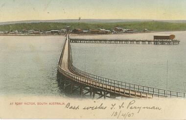 Bendigo Historical Society Inc.
Postcard - GLADYS DEAN COLLECTION: POSTCARD, 1906 - 1908
Coloured photographic postcard of Port Victor South Australia with a 1.5cm white border along the bottom edge. Image is taken from the sea and depicts a long pier curving back to shore with another jetty running off to the right. On the shore many buildings are in the distance against a low green hill. The words At Port Victor, South Australia are printed in red on the left hand side of the border. Handwritten in the border are the words Best wishes T S Perryman 13/4/07 in pencil. On reverse, South Australia Post Card is printed in red with a map of Australia at the top and card is addressed to Miss R Dean Golden Square Victoria. A one penny stamp is affixed postmarked Adelaide.South Australia Post Cardpostcard -
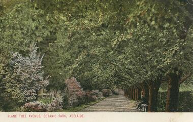 Bendigo Historical Society Inc.
Postcard - GLADYS DEAN COLLECTION: POSTCARD, 1906 - 1908
Coloured photographic postcard with 1cm white border at bottom edge. Image depicts an avenue of plane trees opposite a flower border. A person is seated on a white bench on the right hand side of the avenue. The words Plane Tree Avenue, Botanic Park, Adelaide are printed in red in the border. On the reverse, the words South Australia Post Card are printed with a map of Australia at the top. Card is addressed to Miss R Dean Golden Square Victoria and a one penny stamp is affixed.South Australia Post Cardpostcard -
 Bendigo Historical Society Inc.
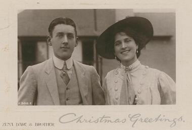
Postcard - GLADYS DEAN COLLECTION: POSTCARD, 1906 - 1908
Photo mounted on backing card with clear protective film over image and card. Black and white image is of a man and woman photographed from the chest up, standing together. They are dressed formally, the man in a pale coloured suit with waistcoat and the woman in a pale coloured shirt with button detail. Both are wearing ties and she is wearing a dark coloured brimmed hat. The number P386E is printed in white in the lower left hand corner of the image. There is a white border varying between .2mm to .5mm around the photograph. The words Zena Dare & Brother are printed in sepia along the lower left hand edge of the backing card. The words Christmas Greetings have been written in silver on the right hand lower edge of the backing card. On reverse card is addressed to Miss Gladys Esmond McKenzie St Golden Square with a one penny stamp affixed post marked Melbourne.Rotary Photographic Plate Sunk Gem Series Rotary Photo EC. P 386Epostcard -
 Bendigo Historical Society Inc.
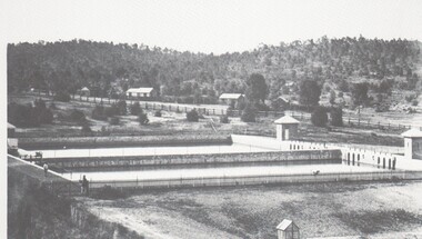
Photograph - HARRY BIGGS COLLECTION: SETTLING PONDS, CRUSOE
... on the left hand side of the photo. In the background there is a post... side of the photo. In the background there is a post and rail ...Photograph (proof56) of the settling ponds at Crusoe Gully Reservoir. There are two of the ponds visible and two men standing on the left hand side of the photo. In the background there is a post and rail fence bordering a roadway and a timbered hill behind these.place, water, settlinbg ponds, settling ponds , crusoe reservoir -
Wangaratta RSL Sub Branch
Postcard
Silk postcard from France written by unknown WW1 soldier from Milawa addressed to Mrs G Kittle/Kettle c/- Post Office Milawa. WW1 service records reveal Charles James KETTLE 29741 was born in Milawa and enlisted on 15/4/1916 aged 39 years. He embarked on the 3/10/1916 and served in France prior to being diagnosed with a tumour and whilst being repatriated home died on 10/8/1917 and was buried at sea. Listed place of association was Wangaratta. Embroidered silk postcards were first made in 1900 for the Paris Exposition. The popularity of silk postcards peaked during the First World War 1914 - 1918.They were mostly embroidered by French women in their homes and then sent to the factories for cutting and mounting on cards. Many of the cards were illustrated with patriotic symbols, flags, slogans, or sentimental texts. During the First World War, many Allied officers and soldiers based in France sent silk embroidered postcards to their loved ones back homeRectangle cream cardboard postcard with embossed border containing coloured embroidered stitch work of a basket and in words “forget me not” on silk Handwritten inside - just a souvenir of your beloved France from one of the boys from Milawa addressed to Mrs G Kettle/Kittle Post Office Milawa via Wangaratta Victoria embroidered postcard, ww1, milawa -
Victorian Aboriginal Corporation for Languages
Conference proceedings, Joan Argenter, Endangered languages and linguistic rights on the margins of nations : proceedings of the Eighth FEL Conference : Barcelona (Catalonia) Spain 1-3 October 2004, 2005
Section 1: Grass-roots Efforts and Top-down Institutions Keynote Address: Leanne Hinton The Death and Rebirth of Native American Languages Patrick Marlow Bilingual Education, Legislative Intent, and Language Maintenance in Alaska Galina Dyrkheeva New Language Policy and Small Languages in Russia: the Buryat Example Zelealem Leyew The Fate of Endangered Languages in Ethiopia Gregory Hankoni Kamwendo Language Planning from Below: Chitumbuka as a Marginalised Language in Malawi John Hobson Learning to Speak Again: Towards the Provision of Appropriate Training for the Revitalization of Australian Languages in New South Wales Shelley Tulloch Grassroots Desires for Language Planning in Nunavut Amandina C�rdenas Demay Hacia la definici�n de una pol�tica del lenguaje & Alejandra Arellano Mart�nez expl�cita en M�xico Elena Benedicto, G. McLean, Linguistic Rights in the Nicaraguan Atlantic Coast: Grupo de Ling�istas Ind�genas Mayangna Actions on the Ground within the Legislative Framework of the Estatuto de Autonom�a Bartomeu Meli� Las lenguas ind�genas en el Paraguay. Una visi�n desde el Censo 2002 Monica Ward Building from the Bottom-up: Linguistic Rights for Extremely Endangered Languages Marta Moskal Language Policy and Protection of Endangered Languages in Poland Sue Wright What is a language? Some difficulties inherent in language rights Joan Ramon Sol� Obstacles in the Way of the Recovery of Catalan Section 2: The Global vs. the Local in Linguistic Rights Keynote Address: Patxi Goenaga Fronteras que dividen y fronteras que separan. Una mirada a Europa desde el Euskara Yun-Hsuan Kuo Languages, Identity, and Linguistic Rights in Taiwan Estibaliz Amorrortu, Andoni Barre�a, What Do Linguistic Communities Think about the Esti Izagirre, Itziar Idiazabal, Bel�n Uranga Official Recognition of their Languages? Alok Kumar Das Linguistic Practices and Not Just Linguistic Rights: Endangered Languages in New Europe Section 3: Languages crossing the Borders Keynote Address: Tjeerd de Graaf The Status of Endangered Languages in the Border Areas of Japan and Russia Mariana Bara Arm�n endangered language Ver�nica Grondona Language Policy, Linguistic Rights and Language Maintenance in Argentina Grup d?Estudi de Lleng�es Amena�ades Linguistic diversity in Catalonia: towards a model of linguistic revitalization Nataliya Belitser Endangered Languages in Crimea/Ukraine: The Cases of Crimean Tatar, Karait, and Krymchak Ivelina Kazakova & Maria Miteva The Future of Bulgarian: The Road to Extinction or Paradise Regained Luke O?Callaghan War of Words: Language Policy in Post Independence Kazakhstan Eden Naby From Lingua Franca to Endangered Language: The Legal Aspects of the Preservation of Aramaic in Iraq Poster presentations Akim Elnazarov Endangered languages and Education. A Case of Badakhshan Province of Tajikistan Arnfinn Muruvik Vonen & Oddvar Hjulstad Linguistic Rights Paving the Way Towards Language Endangerment? The Case of Norwegian Sign Language Eva Savelsberg Kurdish (Kurmanc�) as Minority Language in the Federal Republic of Germany Jos� Antonio Flores Farf�n Cultural and Linguistic Revitalization, Maintenance and Development in Mexico Mary Jane Norris Assessing the Status, Use and Accessibility of Canada?s Aboriginal Languages within Communities and Cities: Some Proposed Indicators Michael Prosser van der Riet Promotion of Minority Language Scripts in Southwest China. A Relative Success or Complete Failure? Mikael Grut The Endangered Celtic Languages: A Wake-up Call Nariyo Kono Developing Partnerships Between Universities and Language Communities: Top-down and Bottom-up Integration Richard J. Hawkins Probit Modeling Language Attrition Rudy Osiel Camposeco El idioma maya Popti? y la Declaraci�n Universal de los Derechos Ling��sticos Victorio N. Sugbo The literary Response: Claiming Rights in Three Philippin Languages Ya-ling Chang Language Policies in an Aboriginal Primary School in Taiwanmaps, tables, graphsnsw, endangered languages, linguistic rights