Showing 1057 items matching "boundaries"
-
 Warrnambool RSL Sub Branch
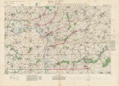
MAP TO ACCOMPANY HEAVY ARTILLERY SCHEME FOR MOBILE WARFARE".....marked with 'Lanes' and Corps/Division Boundaries, Ordnance Survey, 1:40,000, France. Sheet 62c, Dec 1917. (centring on Peronne and Mont St Quentin), December 1917
Shows detail of Artillery Planning in the area of Peronne & Mont St Quentin. Inscribed "Map to accompany H.A. Scheme for Mobile Warfare". Marked with 'Lanes' and Corps/Division Boundaries.The donor, Staff Sergeant R.O. (Bob) Snape, Reg No 8651, enlisted as a Stretcher Bearer in 1915 but, because of his secretarial skills was employed in HQ positions as soon as he arrived in France and as a stenographer who worked as Confidential Clerk to General Sir John Monash from June to December 1918; and subsequently, for General Sir Talbot Hobbs until June 1919. The map was very likely directly used in the planning of the 1918 battles such as Mont St Quentin.Original Item recovered from possibly Australian Corps HQ, probably between the Armistice, 11 November 1918, and June 1919, when Staff Sergeant R.O.(Bob) Snape was repatriated. Shows detail of Artillery Planning in the area of Peronne & Mont St Quentin. Inscribed "Map to accompany H.A. Scheme for Mobile Warfare". Marked with 'Lanes' and Corps/Division Boundaries.snape collection -
 Melbourne Tram Museum
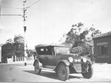
Photograph - 1926 Hudson Super 6 - Riversdale and Warragul Roads, Ray Pearson, 1930s
Photograph of a 1926 Hudson Super 6 parked at the tea room/kiosk on the intersection of Riversdale Road and Warragul Road. Distinguishing features of the car include the triangular badge on the radiator and the unusual disc wheels. The 1926 Hudson also had horizontal radiator shutters. On this vehicle, a finer mesh has been attached in front of the shutters. This is normal practice when insects such as locusts are in plague. At the time, Warragul Road was known as East Boundary Road. Behind the car on the tramway pole is a colour light tramway signal for the single-line section between Warragul Road and the terminus. On 1 July 1928, the Wattle Park line was extended from Boundary Road via Riversdale Road to Elgar Road. It was built as a single track with a passing loop about halfway along, plus a passing loop at the former Boundary Road terminus. The tramway pole has a stop sign and a telephone box as well. In a box of negatives received is an envelope noting the car was owned by Ray Pearson and photo taken during the 1930s. Inside the motor car are two people, the driver, and a lady. In the background is part of the tea rooms located at this corner with a Shell gravity-fed petrol bowser. At the time, petrol was not sold at Service Stations on a Sunday - Sunday trading laws, but they allowed Tea Rooms or kiosks to be open.Yields information the intersection of Warragul and Riversdale Road and MMTB single line signals.Black and white photograph on Velox paper.On rear in pencil "Colour light signal Wattle Park Route, down end loop line, corner of Riversdale and East Boundary Roads".trams, tramways, riversdale road, wattle park, warragul road, motor cars, hudson super 6, shell fuel, signalling, single line, ray pearson -
 Federation University Historical Collection
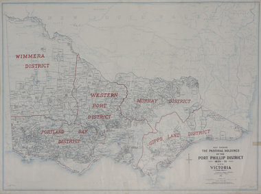
Plan, Map Showing the Pastoral Holdings of the Port Phillip District 1835-1851 Now Victoria, 1932, 1932
Another name for Pastoral Holdings is squatting runs. Information on Alfred Stephen Kenyon of the Historical Society of Victoria can be found at http://adb.anu.edu.au/biography/kenyon-alfred-stephen-6936/text12035 Map of Victoria showing the boundaries of the Port Phillip District (Victoria) pastoral boundaries. pastoral holdings, squatters, squatting, victoria, land, crown lands, a.s. kenyon, alfred stephen kenyon -
 City of Moorabbin Historical Society (Operating the Box Cottage Museum)
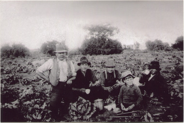
Photograph, Black & White, V Peterson E Boundary Rd E Bentleigh market garden c1925, Original c1925
The Peterson family were early settlers in Moorabbin Shire and established a market garden in East Boundary Road East Bentleigh. Vic Peterson - waistcoat, with Dick Marriott seated - ( brother in -law ), 2 unknown men and 7year old Geoff Peterson - Poliomyelitis as a baby- sitting in front with his walking sticks. The crop is cabbages that would be harvested and sent to the Melbourne markets.The early settlers like the Petersons and Marriotts, in the Parish of Moorabbin County of Bourke after Henry Dendy's Special Survey Brighton 1841, established market gardens, fruit & flower gardens, poultry & dairy farms, vineyards as well as shop businesses, blacksmiths, chemists, nursing homes and schools & Churches.Black & White photograph of Vic Peterson and 3 men & boy on his market garden in East Boundary Road East Bentleigh c1925 re-digitised 2005back ; handwritten information unsignedwagons, vulcan trucks, draught horses,, peterson vic, marriott dick, cabbage crops, vegetable crops, poliomyelitis epidemics 20thc , elster creek, plateways moorabbin shire, smith j l; smith mary ann, stanley helen, smith vic, smith harry redvers, chaff cutter, horse drawn carts, toll gates brighton, motor cars 1900, steam engines, early settlers, bentleigh, mckinnon, parish of moorabbin, city of moorabbin, county of bourke, moorabbin roads board, shire of moorabbin, henry dendy's special survey 1841, were j.b.; bent thomas, o'shannassy john, king richard, charman stephen, highett william, ormond francis, maynard dennis, market gardeners, vineyards, orchards -
 Whitehorse Historical Society Inc.
Map, Aerial Photographs Nunawading, 1970
State Aerial Survey, Melbourne 1970.State Aerial Survey, Melbourne 1970. Project runs 34 - 39 - City of Nunawading. Frames numbered from South to North boundaries, each strip numbered from East to West. See table of index and photo numbers attached.non-fictionState Aerial Survey, Melbourne 1970.state aerial survey, aerial photographs, nunawading, mitcham, blackburn, blackburn north, blackburn south, forest hill, vermont, burwood east, vermont south -
 University of Melbourne, Burnley Campus Archives
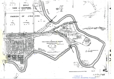
Plan, Allan & Tuxen et al, Public Park & Recreation Reserve (Richmond Park), 1886-1996
Shows changes in ownership of various parts of Richmond Park and Burnley Gardens including University of Melbourne, Amrad, Melbourne City Link, etc. from gazettal in 1873 to 1996Photocopy of plan of Richmond Park and Burnley Gardens with University of Melbourne land acquisition 13.10.1994 hand drawn on it, dates Act revoked and Gazette numbers. Based on plan of Parish of Jika Jika R 19 (3)"Changes to ownership & boundaries of Gardens" in inkpublic parks, recreation reserve, richmond, parish if jika jika, burnley gardens, horticultural society of victoria -
Whitehorse Historical Society Inc.
Map, Aerial photographs Nunawading, 1976
Department of Crown Lands and Survey, Melbourne, 1976 Project.Department of Crown Lands and Survey, Melbourne, 1976 Project. Runs 29 - 33 City of Nunawading. Frames numbered from South to North boundaries, each strip numbered from West to East. No index map. Sheets 30/8 and 30/9 missing.non-fictionDepartment of Crown Lands and Survey, Melbourne, 1976 Project. victoria. department of crown lands and survey, aerial photographs, nunawading, mitcham, blackburn, blackburn north, blackburn south, forest hill, vermont, vermont south, burwood east, box hill, ringwood -
 City of Moorabbin Historical Society (Operating the Box Cottage Museum)
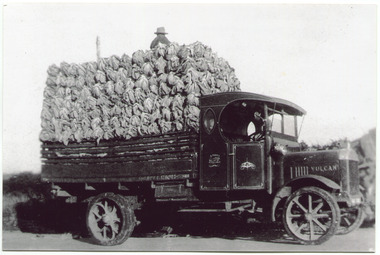
Photograph, Black & White, V Peterson, loaded Vulcan Truck 1929, c1929
The Peterson family were early settlers in Moorabbin Shire and established a market garden in East Boundary Road East Bentleigh. Horse drawn wagons traveled along Plateways to take their crops to the Melbourne Markets . With the advent of the motorcar the market gardeners gradually purchased trucks to transport their crops. Roads were being surfaced but ruts and flooding caused upsets and bogging of these trucks. The journey was quicker but unlike the Horses, these trucks could not drive themselves back to the farm.The early settlers like the Petersons and Marriotts, in the Parish of Moorabbin County of Bourke after Henry Dendy's Special Survey Brighton 1841, established market gardens, fruit & flower gardens, poultry & dairy farms, vineyards as well as shop businesses, blacksmiths, chemists, nursing homes and schools & Churches.Black & White photograph of a Vulcan truck driven by Vic Peterson, loaded with Cauliflowers from his market garden in East boundary Road East Bentleigh c 1929.Back Handwritten information unsgnedwagons, vulcan trucks, draught horses,, peterson vic, marriott dick, cauliflower crops, vegetable crops, poliomyelitis epidemics 20thc , elster creek, plateways moorabbin shire, smith j l; smith mary ann, stanley helen, smith vic chaff cutter, horse drawn carts, toll gates brighton, motor cars 1900, steam engines, early settlers, bentleigh, mckinnon, parish of moorabbin, city of moorabbin, county of bourke, moorabbin roads board, shire of moorabbin, henry dendy's special survey 1841, were j.b.; bent thomas, o'shannassy john, king richard, charman stephen, highett william, ormond francis, maynard dennis, market gardeners, vineyards, orchards -
 Ballan Shire Historical Society
Map - Map. Ballark, Department of Lands and Survey, Ballark. County of Grant, 31/08/1915
A map of the Ballark area within the County of Grant showing roads, waterways, property boundaries and property owners in 1915.Significant to people researching land usage and ownership. Also those researching families in the area at that time.A map of Ballark in the County of Grant. Black printing on buff coloured paper. Extra notations by hand and various coloured highlighting of certain features. Details roads, rivers, property boundaries and names of property owners and districts. The map is easily readable although there is some physical damage to the borders and some sellotape residue. Shows a scale in Chains and the number L.6030Various numbers and directional arrows added to map.bungal, borhoneyghurk, bungeeltap, ballark, beremboke, moreep, meredith, morrisons, moorarbool river -
 Orbost & District Historical Society
photographs, Lawless, Ray
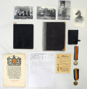
These photographs are part of the Lawless Collection. The Lawless family lived in Orbost from 1907 - c 1920. John Francis Lawless had a saddlery shop. He died at an early age - 47 years - June 7 1912, leaving his wife, Elizabeth and seven children. The eldest son, Victor Rowland lawless volunteered for serv ice in WW1 but did not leave Australia because of illness. The second son, Edward Vincent Lawless (b 1895 d 1917) worked for McCoy & Co. in Orbost, coachbuilding, undertakers, general blacksmiths and farriers, prior to enlisting in WW!. He was trained as a signaller and was sent to France where he was killed in action on 9.10.1917. Elizabeth Lawless worked as a ladies' nurse (midwife) in Orbost prior to leaving the district in 1920. She lived to 6.6.1975 aged 104 years.These personal documents, photographs and books give an insight into the human element of World War 1 ensuring that those who were part of the Orbost community and died while playing a vital role during this time are remembered.Four black and white copies of photographs of the Lawless family. 1846.8 is a photograph of Ted Lawless. 1846.9 is a photograph of Ruby Lawless Wallace and Ray Lawless at Elizabeth Lawless' house. 1846.10 is a photograph of the Lawless family at the Boundary Road house in Orbost.1846.8 on back - Ted Lawless 1846.9 on back - Ruby Lawless 1846.10 on back - Family with Elizabeth 1846.11 on back - Grandmother 21st Battalion Wallace wife at Home Boundary Rd Lawless AIF & Ray at Grandma Orbost Lawless House It is still there Orbost? Ray Lawless June 2010photographs lawless-family -
 City of Kingston
Photograph - Black and white, c. 1960
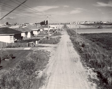
This image depicts a scene of East Bentleigh in 1960, viewed along Thomasina Street as it crosses Gladwyn Street towards East Boundary Road in the distance. The gardens and new homes are well-tended, but the street surfacing is unsealed.Developing urban area now located within the City of Glen Eira, formally City of Moorabbin. This image illustrates the mid century urban sprawl of new suburbs and the subdivision of market gardens within the municipality and the changing demographic of the district as new houses are constructed and infrastructure established. Black and white photograph of unsealed road in new development in the area of Moorabbin, new houses appear on the lefthand side with paddocks on right side of image with installation of electric poles. Sealed road in the distance. Thomasina Street, as it crosses Gladwyn Street, East Bentleigh towards East Boundary Road. Handwritten in blue ink: 60 - 373 D Handwritten in red ink: 80% Handwritten in black ink: Ch. 6bentleigh, east bentleigh, market garden, housing, suburbs, infrastructure, moorabbin -
Whitehorse Historical Society Inc.
Article, Attack on 'emotional blackmail', 1994
Emotive claims that Box Hill faced a takeover by Nunawading if the City of Whitehorse did not go ahead have outraged Nunawading Mayor, Kevin Abbott.Emotive claims that Box Hill faced a takeover by Nunawading if the City of Whitehorse did not go ahead have outraged Nunawading Mayor, Kevin Abbott. Cr Abbott said Box Hill was publicly distancing itself from Nunawading yet privately it has considered extending its boundary to divide Nunawading at Blackburn Road.Emotive claims that Box Hill faced a takeover by Nunawading if the City of Whitehorse did not go ahead have outraged Nunawading Mayor, Kevin Abbott. local government, city of nunawading, city of box hill, abbott, kevin, amalgamations -
Whitehorse Historical Society Inc.
Article, School to fight brothel
Blackburn Primary School want City of Nunawading to 'stand up' against the Alfred Street brothel application.Blackburn Primary School want City of Nunawading to 'stand up' against the Alfred Street brothel application. The school strongly supports the principle of the private members bill moved in the Parliament by the Nunawading Province member, Mrs Rosemary Varty. It aims to give Councils the right to veto brothel applications within their boundaries.Blackburn Primary School want City of Nunawading to 'stand up' against the Alfred Street brothel application. brothels, blackburn primary school, no. 2923, city of nunawading, victoria. planning appeals board, varty, rosemary, alfred street, blackburn -
 Greensborough Historical Society
Photograph, Banyule Homestead 2011, 2000c
These photos were part of an objection to the proposed development and subdivision of part of the historic Banyule Homestead property.The Banyule Homestead dates from 1846, owned and built by Joseph Hawdon, sold in 1867 to Dr Martin. Leased to various farmers and eventually the land (274 acres) was subdivided in 1958. The Homestead presently sits on 2 1/2 acres of land. Set of 4 x A3 photos. Colour.Taken from western boundary overlooking lagoon.banyule homestead, joseph hawdon, heidelberg -
Whitehorse Historical Society Inc.
Map, Nunawading Shire, 1892
Photocopy of an enlargement of map of Shire of Nunawading showing landowners in 1892.Photocopy of an enlargement of map of Shire of Nunawading showing landowners in 1892. Covers Middleborough Road to Ringwood boundary. One map (Blackburn) from north of Whitehorse Road to Highbury Road, 2nd map (Mitcham) Bulleen to south of Canterbury Road; 3rd map Whitehorse Road to Highbury Road.Photocopy of an enlargement of map of Shire of Nunawading showing landowners in 1892. maps, shire of nunawading, blackburn, blackburn south, nunawading, forest hill, vermont, mitcham, vermont south -
 Bendigo Historical Society Inc.
Document - CITY OF BENDIGO WARD BOUNDARIES
One page typewritten document titled City of Bendigo Ward Boundaries. The document details the boundaries of the Sutton, Darling and Barkly wards.government, local, city of bendigo -
 City of Kingston
Photograph - Black and white, 1914
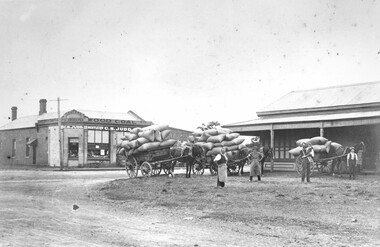
Judd's General Store was on the corner of Centre and East Boundary roads in East Bentleigh. This image shows unsealed roads at an intersection with loaded wagons for transporting (or recently transported). The building in the immediate background has a ghost sign which is now illegible. The photograph was apparently taken nine (9) days after the declaration of World War I. Orlando Judd is second from left.Black and white image of four men standing outside in front of three horse drawn wagons loaded with hessian bags. They are standing in front of Judd's General Store which was on the corner of Centre and East Boundary roads, East Bentleigh.White round sticker on reverse with black printed text: 79 Handwritten in red ink on reverse: 60%east bentleigh, horses, horse drawn wagon, commerce -
Whitehorse Historical Society Inc.
Map, Nunawading, 1966
Nunawading's boundaries, schools, topography and railwaysNunawading's boundaries, schools, topography and railwaysNunawading's boundaries, schools, topography and railwaysmaps, city of nunawading, schools -
Whitehorse Historical Society Inc.
Map, Melbourne Geological Map, 1937
Geological Map of Melbourne & Suburbs.Geological Map of Melbourne & Suburbs. Scale: 40 chains to 1 inch with inset 10 miles to 1 inch. Includes Municipal and Parish boundaries, railways and stations, electric tramways, cable tramways, Post Offices and State schools. Area bounded by Braybrook, Preston, Blackburn & Brighton. Printed on linen.Geological Map of Melbourne & Suburbs. melbourne, maps -
Whitehorse Historical Society Inc.
Document, Shire of Blackburn and Mitcham, 1926
By-laws nominating boundaries of ridings and 'Populous areas'.By-laws nominating boundaries of ridings and 'Populous areas'.By-laws nominating boundaries of ridings and 'Populous areas'.local government, shire of blackburn and mitcham -
Whitehorse Historical Society Inc.
Document, Mitcham Letter Delivery, 1926
Delivery of Mitcham letters within prescribed boundaries.Delivery of Mitcham letters within prescribed boundaries.Delivery of Mitcham letters within prescribed boundaries.postal services, mitcham -
 Lakes Entrance Historical Society
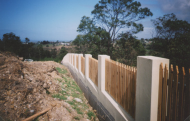
Photograph - Garden Cemetery Lakes Entrance Victoria, Lakes Post Newspaper, Western boundary of Garden Cemetery Lakes Entrance Victoria, 2003
Colour photograph of new boundary fence at Western boundary of Garden Cemetery Lakes Entrance Victoria. Also a second photograph of fence from a different anglegenealogy, cemeteries, topography -
Whitehorse Historical Society Inc.
Map, VR Box Hill - Blackburn, 1953
Maps of proposed station at Laburnum on Box Hill to Blackburn railway lines, by Victorian Railways, showing boundaries of Victorian Railways land and the proposed boundaries for Laburnum Station.Maps of proposed station at Laburnum on Box Hill to Blackburn railway lines, by Victorian Railways, showing boundaries of Victorian Railways land and the proposed boundaries for Laburnum Station.Maps of proposed station at Laburnum on Box Hill to Blackburn railway lines, by Victorian Railways, showing boundaries of Victorian Railways land and the proposed boundaries for Laburnum Station.laburnum railway station, laburnum street, blackburn, victorian railways -
Whitehorse Historical Society Inc.
Map, City of Nunawading, c. 1960
Map showing boundaries of the City of Nunawading Scale: 1:36,000Map showing boundaries of the City of Nunawading Scale: 1:36,000Map showing boundaries of the City of Nunawading Scale: 1:36,000mitcham, nunawading, blackburn, blackburn north, blackburn south, burwood east, vermont south, forest hill, vermont -
Southern Sherbrooke Historical Society Inc.
Map, "Melway Melbourne Town & Country Wall Map, Municipal Edition 1983", 1983
Wall map showing municipal boundaries prior to 1995 amalgamations.melbourne -
 Melton City Libraries
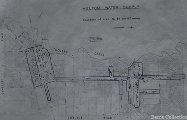
Map, Melton Water Supply, Unknown
The development that had arguably the greatest impact in encouraging population growth in the shire during this period, was the establishment of a reliable water supply for the district. This had been a major concern of the local community for over 100 years, since the Melton township was first founded. Despite various schemes over the years to create a reliable water supply, the district was still dependent on bores, wells and tanks when the Melton Waterworks Trust was established in 1961 to address Melton’s water woes. With the opening of the Djerriwarrh Dam in December 1963, the shire’s residents finally had access to a reticulated water supply.Map shows the boundary of the area where the water will be serviced in the towncouncil -
Whitehorse Historical Society Inc.
Map, Aerial photographs Nunawading, 1972
Department of Crown Lands and Survey, Melbourne, 1972.Department of Crown Lands and Survey, Melbourne, 1972. Project runs 34 - 39 - City of Nunawading. frames numbered from South to North boundaries, each strip numbered from West to east. The series extends further West to Box Hill and East to Ringwood than the 1970 project. No index map. Sheets 39/2 and 34/28 missing.non-fictionDepartment of Crown Lands and Survey, Melbourne, 1972.victoria. department of crown lands and survey, aerial photographs, nunawading, mitcham, blackburn, blackburn north, blackburn south, forest hill, vermont, burwood east, box hill, ringwood, vermont south -
 Surrey Hills Historical Society Collection
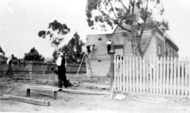
Photograph, St George's Church of England, Mont Albert working bee, early 1923 (1), 1923
The foundation stone for St George's Church of England, Mont Albert was laid in 1886 on land donated by Edward Dyer and the first service was preached in January 1887. From 1904 until 1907 it was known as Holy Trinity, Surrey Hills. The original church was weatherboard and replaced by a brick one in the Gothic Revival style which was designed by local architect George J V Blackburne, who also designed the Wesleyan School at Surrey Hills. The building was partly funded by donations, profits from a bazaar and concert, and other people donated furnishings. The church had boundaries along Mont Albert Road and St Georges Road. In 1998 the Church was sold and converted into a complex of units. Its current address is 19 St Georges Avenue, Mont Albert. Norman Carter took many photos of Surrey Hills and Mont Albert from the 1920s, in particular of events and activities associated with the Church of England.Black and white photo of 4 men at a working bee in the grounds of St George's Anglican Church in Mont Albert. Two men are on a scaffold working on the weatherboards of the church; the other two are working on fencing. One boundary is marked with a paling fence; the other has a section of picket fencing and a large open section with no fencing. There is a mature eucalyptus tree in front of the church; others are beyond the paling boundary fence. The church itself is a simply constructed weatherboard building.churches, holy trinity church, anglican church, st george's anglican church, working bees, norman brodley carter -
 Williamstown High School
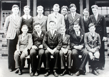
Boy prefects 1936
Copy of black and white photographed mounted on card. 2nd laminated copy. Comes with caption.Boy prefects and boys 1936, outside pavilion on Verdon St boundary.williamstown high school, 1936, prefects -
Port Melbourne Historical & Preservation Society
Flyer - 1992 Port Melbourne Council Election, 02 It's time for a change, Jul 1992
Produced in 1992 as two more women successfully ran for Port Melbourne City Council. Kept by donor until 2018 - Port Melbourne Electoral Material 1992 - Lyn Allison, Boundary ward .02 In ink on back "Di"local government - city of port melbourne, elections, lyn allison