Showing 822 items
matching military map
-
 Bendigo Military Museum
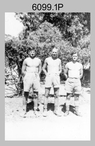
photograph - Fortuna - 1st Year of Army Occupation in Bendigo, 1942
... building works necessary to accommodate the Survey Corps’ military... building works necessary to accommodate the Survey Corps’ military ...This is a set of 17 photographs taken during the first year of Army occupation at Fortuna, Bendigo in 1942. The photos provide an insight into the preparatory work performed on the Fortuna Villa and surrounding buildings, by the Working Party 5th Army Troop and Ordnance Training Depot, before its occupation by personnel from LHQ Cartographic Company, Royal Australian Survey Corps. The annotation on the back of Photos .9P and .10P is misspelt. The correct spelling is ‘Nell Gwynne’. The poppet head of the Central Nell Gwynne mine is still an iconic landmark in Bendigo, lying just down the road from the poppet head lookout at Victoria Hill. The Central Nell Gwynne was the premier mine of Bendigo's 1930s mining revival and is of high historical value, due to the extensive and relatively intact features which remain at the site. The annotation on the back of Photo .17P is incorrect. The location of HQ 5th Army Troop was ‘Reynard St, Coburg.’ By late 1941 as Japan extended its control throughout Indo-China, resolving the accommodation problem of AHQ Cartographic Company located in Melbourne became more urgent. The steady Japanese advance made the bombing of Melbourne no longer a remote possibility, and in accordance with a general policy of dispersion, the Deputy Chief of the General Staff, Major General Sidney Rowell instructed Major William Sarll, in the interests of security of plant and to provide against possible damage of air attack, to investigate suitable safer inland accommodation for AHQ Cartographic Company. Major Sarll inspected many properties before finding one that would meet the requirements of the Cartographic Company. In late 1941, he came to inspect Fortuna, a rambling old mansion with about fifteen acres of ground in central Bendigo. Initially there was no intention to occupy the site beyond the end of the war, although Major Sarll's report to the Director of Survey noted many advantages in moving the Company to Bendigo. Major General Rowell quickly approved the selection of Fortuna before other authorities, which were investigating the evacuation of school children, could get in ahead of the Cartographic Company. On 23 March 1942, the Commonwealth of Australia, under the provisions of the National Security Act of 1939, took possession of the house, the old battery buildings and the fifteen acres of grounds. Under Warrant Officer J. Trist’s direction, over fifty Parks and Works tradesmen completed building works necessary to accommodate the Survey Corps’ military, map making and printing requirements. The building program was still under way when the first officer, Lieutenant Ralph Westgarth, arrived in May 1942 with the advance party which received and positioned all equipment as it came up from Melbourne in semi-trailers. Once the equipment was installed the rest of the Cartographic Company completed its shift to Bendigo by 11th June 1942. The first year of the Survey Corps’ occupation of Fortuna is covered in more detail with additional historic photographs, in pages 17-22 of Valerie Lovejoy’s book 'Mapmakers of Fortuna – A history of the Army Survey Regiment’ ISBN: 0-646-42120-4.This is a set of 17 photographs taken during the first year of Army Occupation at Fortuna, Bendigo in 1942. The black and white photographs were printed on photographic paper and are part of the Army Survey Regiment’s Collection. The photographs were scanned at 300 dpi. .1) - Photo, black & white, 1942. Bendigo Parks and Works tradesmen at Fortuna. L to R: Cliff Day, Ernie Arnold, Norm? .2) - Photo, black & white, 1942. “Don” - possibly SGT Don Sutcliffe. Fortuna, Bendigo. .3) - Photo, black & white, 1942. Parks and Works tradesmen in garden at Fortuna, Bendigo. L to R: Fred & Ernie. .4) - Photo, black & white, 1942. Benny Jack Williams at Fortuna, Bendigo. Accommodation tents were erected above the lake, which later became the parade ground. .5) - Photo, black & white, 1942. Working dress - Giggle suits. Parks and Works tradesmen at Fortuna, Bendigo. L to R: Cliff and Harry on big roof. .6) - Photo, black & white, 1942. Parks and Works tradesmen at Fortuna, Bendigo. Ted on big roof. .7) - Photo, black & white, 1942. Gold crusher battery just behind Fortuna. .8) - Photo, black & white, 1942. Scene of Bendigo from Fortuna. .9) - Photo, black & white, 1942. Nell Gwynne Mine from mullock heap at Victoria Hill near Fortuna, Bendigo. .10) - Photo, black & white, 1942. Nell Gwynne Mine and crusher near Fortuna, Bendigo. .11) - Photo, black & white, 1942. Sluicing for gold at Eaglehawk. .12) - Photo, black & white, 1942. Fortuna, Bendigo taken from the far side of tennis courts. .13) - Photo, black & white, 1942. Fortuna, Bendigo & its reflection from across the lake. .14) - Photo, black & white, 1942. Fortuna, Bendigo from the fishpond. .15) - Photo, black & white, 1942. Fortuna, Bendigo. .16) - Photo, black & white, 1942. First Fortuna Football Team at unknown location. L to R: 5th Bob Wright, 11th SGT Don Sutcliffe. .17) - Photo, black & white, 1942. Working Party from 5th Army Troop and Ordnance Training Depot at Fortuna, Bendigo.Some personnel are identified. Annotated with date within photos. .1) – Annotated on back ‘Cliff, Ernie, Norm, Dec ‘42. Cliff Day - dairy farmer, plasterers’ labourer. Ernie Arnold – hard plasterer. Norm? - QM Store for tools etc. QM Store was the Stables.’ .2) - Annotated on back ‘Don. Fortuna 1942’ .3) - Annotated on back ‘Fred & Ernie. Dec 1942. Carpenters. Note the state of the gardens.’ .4) - Annotated on back ‘Benny Jack Williams Fortuna Bendigo. Tents were erected where present day parade ground is above the lake.’ .5) - Annotated on back ‘Working dress - Giggle suits. June 42. Cliff and Harry on big roof. This photo was taken as the ventilating ridge was being installed on the building housing the printing machines. The machines were installed later by civilian labour when building was complete.’ .6) - Annotated on back ‘Ted on big roof Fortuna Bendigo.’ .7) - Annotated on back ‘Gold crusher battery – Bendigo for slay heap – 1942. 12 stamp battery. Just behind Fortuna. Was working at night when the “Army” came to Bendigo. Later removed to “Coolgardie - WA. Present site of Southern Cross TV.’ .8) - Annotated on back ‘Scene of Bendigo from Fortuna. June 1942.’ .9) - Annotated on back ‘Nell Gwyne Mine from mullock heap (Victoria Hill) Sept 1942.’ .10) - Annotated on back ‘Nell Gwyne Mine and crusher September 1942.’ .11) - Annotated on back ‘Sluicing for gold at Eaglehawk. August 1942.’ .12) - Annotated on back ‘Fortuna Bendigo 1942. Taken from far side of tennis courts.’ .13) - Annotated on back ‘ “Fortuna” across the lake & reflection.’ .14) - Annotated on back ‘Fortuna from fishpond June 1942.’ .15) - Annotated on back ‘Fortuna Dec 1942.’ .16) - Annotated on front ‘X’ x2. Annotated on back First Fortuna Football Team 1942‘Bob Wright’, ‘SGT Don Sutcliffe’. .17) - Annotated ‘Working Party at Fortuna before one of the drafts’, Working Party 5th Army Troop and Ordnance Training Depot Showgrounds, now the Sportsground Bendigo’, ‘HQ of 5th Army Troop was Reynards Rd, Coburg.’royal australian survey corps, rasvy, army survey regiment, army svy regt, fortuna, asr -
 Orbost & District Historical Society
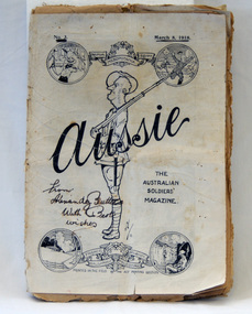
magazine, Aussie, March 18, 1918
Alexander Butters enlisted on 12 November 1914 as a gunner. He was awarded a Meritorious Service medal for his "determination and courage .....setting a splendid example to his men..." on the SOMME. 'Aussie' (1918- circa 1929) was a commercial magazine of opinion, review and entertainment. It was edited by Phillip Harris and published in France 1918 - 1919 on a small printing press that Harris brought with him to France. Initially the print run was only 10,000 copies, but soon it reached 60,000 and later 100,000. The magazine celebrated a distinctive 'Aussie' identity through language, humour and imagery. It distributed news, provided light-hearted ways of seeing the war experience and gave soldiers an outlet to express dissent or dissatisfaction. It also provided a voice for Australian authors such as Banjo Paterson, C.J. Dennis and Bernard O'Dowd. (Ref Museum Victoria)This magazine provides an Australian soldiers' view of the political and world climate during World War I, and also represents the bond between Australian soldiers. The magazine celebrated a distinctive ?Aussie? identity, through language, humour and their assertion of what it meant to be an Australian. It allowed news to be distributed, gave the soldiers an outlet to express any dissent or dissatisfaction, thus preventing any greater form of rebellion and promoted Australian authors like Banjo Paterson, C.J. Dennis and Bernard O'Dowd. (Ref. Museum Victoria)A thin black and white paper magazine called "Aussie". This is Volume 3. The magazine contains stories, illustrations, songs and poetry from the First World War. On the front cover the title is printed across the centre, with a drawing of a soldier in uniform standing sideways, and holding a gun. Four drawings within circles are positioned in each corner, joined by a wreath and ribbons bearing the names of the war fields. His head is in the shape of the map of Australia. On front cover - From Alexandy Butters with best wishesmagazine ww1 aussie military -
 Orbost & District Historical Society
book, Remember Them, 2009
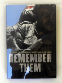
This guidebook shares the personal stories of the individuals honoured in 250 of Victoria's key war memorials. It covers metropolitan Melbourne and regional Victoria, providing a unique insight into wartime history and the local heroes who fought overseas. Garrie Hutchinson has authored and edited over 30 books, In the early 1970s Hutchinson was heavily involved in anti-war activism and alternative journalism. From the late 1970s Hutchinson moved away from writing poetry and towards a journalistic career.This is a significant research tool.A 308 pp hard cover book with a dust jacket titled Remember Them, A guide to Victoria's Wartime Heritage. The author is Garrie Hutchinson. On the front cover is a photograph of a close-up image of a sculpture of a soldier. The text is dark grey.It is arranged geographically, with accompanying maps and photographs,military-history memorials-victoria -
 Flagstaff Hill Maritime Museum and Village
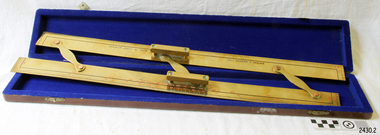
Parallel Rule, 1947-1950
... to produce and develop marine instruments for commercial and military ...Navigators use parallel rule with maps and charts for plotting a specific course on a chart. One long edge is used with the compass rose on the chart, aligning the centre of the rose with the desired direction around the edge of the rose. The compass bars are then ‘walked’ in and out across the map to the desired location so that lines can be plotted to represent the direction to be travelled. Kelvin Company History: The origins of the company lie in the highly successful and strictly informal relationship between William Thomson (1824-1907), Professor of Natural Philosophy at Glasgow University from 1846-1899 and James White, a Glasgow optical maker. James White (1824-1884) founded the firm of James White, an optical instrument maker in Glasgow in 1850 and was involved in supplying and mending apparatus for Thomson university laboratory and working with him on experimental constructions. White was declared bankrupt in August 1861 and released several months later. In 1870, White was largely responsible for equipping William Thomson laboratory in the new University premises at Gilmore hill. From 1876, he was producing accurate compasses for metal ships to Thomson design during this period and this became an important part of his business in the last years of his life. He was also involved in the production of sophisticated sounding machinery that Thomson had designed to address problems encountered laying cables at sea, helping to make possible the first transatlantic cable connection. At the same time, he continued to make a whole range of more conventional instruments such as telescopes, microscopes and surveying equipment. White's association with Thomson continued until he died. After his death, his business continued under the same name, being administered by Matthew Edwards until 1891 when he left to set up his own company. Thomson who became Sir William Thomson and then Baron Kelvin of Largs in 1892, continued to maintain his interest in the business after James White's death in 1884, raising most of the capital needed to construct and equip new workshops in Cambridge Street, Glasgow. At these premises, the company continued to make the compass Thomson had designed during the 1870s and to supply it in some quantity, especially to the Admiralty. At the same time, the firm became increasingly involved in the design, production and sale of electrical apparatus. In 1899, Lord Kelvin resigned from his University chair and became, in 1900, a director in the newly formed limited liability company Kelvin & James White Ltd which had acquired the business of James White. At the same time Kelvin's nephew, James Thomson Bottomley (1845-1926), joined the firm. In 1904, a London branch office was opened which by 1915 had become known as Kelvin, White & Hutton Ltd. Kelvin & James White Ltd underwent a further change of name in 1913, becoming Kelvin Bottomley & Baird Ltd. Hughes Company History: Henry Hughes & Sons were founded in 1838 in London as a maker of chronographic and scientific instruments. The firm was incorporated as “Henry Hughes & Sons Ltd” in 1903. In 1923, the company produced its first recording echo sounder and in 1935 a controlling interest in the company was acquired by S Smith & Son Ltd resulting in the development and production of marine and aircraft instruments. Following the London office's destruction in the Blitz of 1941, a collaboration was entered into with Kelvin, Bottomley & Baird Ltd resulting in the establishing “Marine Instruments Ltd”. Following the formal amalgamation of Kelvin, Bottomley & Baird Ltd and Henry Hughes & Sons Ltd in 1947 to form Kelvin & Hughes Ltd. Marine Instruments Ltd then acted as regional agents in the UK for Kelvin & Hughes Ltd who were essentially now a part of Smith's Industries Ltd founded in 1944 and the successors of S Smith & Son Ltd. Kelvin & Hughes Ltd went on to develop various marine radar and echo sounders supplying the Ministry of Transport, and later the Ministry of Defence. The firm was liquidated in 1966 but the name was continued as Kelvin Hughes, a division of the Smiths Group. In 2002, Kelvin Hughes continues to produce and develop marine instruments for commercial and military. This model parallel map ruler is a good example of the commercial diversity of navigational instruments made by Kelvin & Hughes after World War II. It was made in numbers for use by shipping after the second world war and is not particularly rare or significant for it's type. Also it was made no earlier than 1947 as the firms of Kelvin, Bottomley & Baird Ltd and Henry Hughes & Sons Ltd who took over from Smith & Sons were not amalgamated until 1947. It can therefor be assumed that this ruler was made during the company's transitional period to Kelvin & Hughes from Smith Industries Ltd.Brass parallel rule in wooden box with blue felt lining.Rule inscribed on front "Kelvin & Hughes Ltd" " Made in Great Britain"flagstaff hill, warrnambool, shipwrecked-coast, flagstaff-hill, flagstaff-hill-maritime-museum, maritime-museum, shipwreck-coast, flagstaff-hill-maritime-village, parallel rule, kelvin & hughes ltd, map ruler, plot direction, navigation, maps, echo sounder, kelvin & james white, lord kelvin, baron kelvin of largs, scientific instrument -
 Flagstaff Hill Maritime Museum and Village
Parallel Rule, 1947-1955
History/Context: In 1947, the scientific instrument manufacturing firms of Henry Hughes & Son Ltd, London, England, and Kelvin Bottomley & Baird Ltd, Glasgow, Scotland, came together to form Kelvin & Hughes Ltd. Hughes Company History: Henry Hughes & Sons were founded in 1838 in London as a maker of chronographic and scientific instruments. The firm was incorporated as “Henry Hughes & Sons Ltd” in 1903. In 1923, the company produced its first recording echo sounder and in 1935 a controlling interest in the company was acquired by S Smith & Son Ltd resulting in the development and production of marine and aircraft instruments. Following the London office's destruction in the Blitz of 1941, a collaboration was entered into with Kelvin, Bottomley & Baird Ltd resulting in the establishing “Marine Instruments Ltd”. Following the formal amalgamation of Kelvin, Bottomley & Baird Ltd and Henry Hughes & Sons Ltd in 1947 to form Kelvin & Hughes Ltd. Marine Instruments Ltd then acted as regional agents in the UK for Kelvin & Hughes Ltd who were essentially now a part of Smith's Industries Ltd founded in 1944 and the successors of S. Smith & Son Ltd. Kelvin & Hughes Ltd went on to develop various marine radar and echo sounders supplying the Ministry of Transport, and later the Ministry of Defence. The firm was liquidated in 1966 but the name was continued as Kelvin Hughes, a division of the Smiths Group. In 2002, Kelvin Hughes continues to produce and develop marine instruments for commercial and military use. (See Note section this document for further information on the company's origins)This model parallel map ruler is a good example of the commercial diversity of navigational instruments made by Kelvin & Hughes after world war 2. It was made in numbers for use by shipping after the second world war and is not particularly rare or significant for its type. Also, it was made no earlier than 1947 as the firms of Kelvin, Bottomley & Baird Ltd and Henry Hughes & Sons Ltd who took over from Smith & Sons were not amalgamated until 1947. It can there for be assumed that this ruler was made during the company's transitional period to Kelvin & Hughes from Smith Industries Ltd.Metal parallel rule with Kelvin & Hughes Ltd, Made in Great Britain imprinted, numerous measurements, two handles and 3 hinges.flagstaff hill, warrnambool, shipwrecked-coast, flagstaff-hill, flagstaff-hill-maritime-museum, maritime-museum, shipwreck-coast, flagstaff-hill-maritime-village, parallel rule, kelbin & hughes ltd, metal parallel rule -
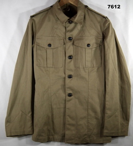
 Bendigo Military Museum
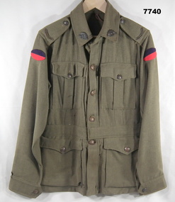
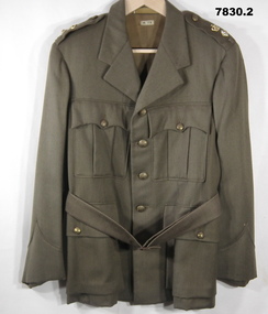
Uniform - JACKET, BATTLE DRESS - ARMY, Australian Defence Industries, 1942
Jacket - Khaki colour wool serge fabric. Battle Dress style with belt at waist. Brown metal buttons with shank and split pin. Buttons have raised emblem - map of Australa and Crown and lettering "AUSTRALIAN MILITARY FORCES". Collar, shoulder epaulettes, four front pockets with button down flaps, sleeve cuffs. Unit colour patch insignia - handmade purple over red - 38th Battalion. Collar badges - metal - Rising Sun Badge. Shoulder epaulettes - metal "AUSTRALIA" badge. Manufacturers white cotton fabric label - inside right pocket.Manufacturers information on two labels. Black ink print - "REGIMENTAL NO./NAME" Red ink print - "V162/ MADE IN/ AUSTRALIA/ 1942/ size". Handwritten black ink pen "XXX/ 20X" uniform, army, battle dress, ww2 -
 Bendigo Military Museum
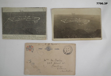
Postcard - POSTCARD - HURDCOTT, AIF CAMP, UK, R. H. Baron, 3. 3/11/1918
Cards relate to R.H. Baron's time at Hurdcott AIF Camp during 1918. Part of the "Robert H. Baron", No. 3596, and Cooper Collection. See Catalogue No. 1981P for details of Baron's service.1. Black and white newspaper clipping pasted onto a piece of cream card. Clipping features a black and white photograph of a map of Australia carved into the side of a hill. Caption in black type below photograph. 2. Black and white postcard style photograph of a map of Australia carved into the side of a hill. 3. Plain cream coloured postcard with YMCA logo and AIF insignia at the top. Handwritten address on front and handwritten letter on back.1. Handwritten in black ink on back: 'This map has been cut in the hill and is only about 10 minutes walk from here, Bob' 3. Handwritten in black ink on front: 'Miss M. Baron, 208 Forest St. Bendigo, Victoria, Australia'. Stamped in black on top R.H.C. of front: 'Postmark - AIF Camp P.O. No.4, 18,' Handwritten in black ink on back: 'Letter to R.H. Baron's sister Myrtle from Hurdcott Camp dated 3.11.18.'robert h. baron, cooper collection, postcards, hurdcott aif camp -
 Bendigo Military Museum
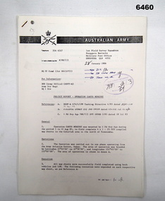
Administrative record - 1 Fd Svy Sqn Project Report - Operation Carto Mercury 1986, 28 Jan 1986
Operation Carto Mercury was a field completion Operation mounted by 1 Fd Svy Sqn 11 Aug 1985 to field complete 4 x 1:25000 compiled map sheet in the Cabarlah area to the North of Tawoomba. Included maps: 9243 - 23 Kingsthorpe, 9243 -24 Goombungee, 9243 - 21 Gomaren Creek, 9243 - 22 High FieldsA4 Typed document and diagrams, 14 pages. Report produced by 1 Fd Svy Sqn 1986royal australian survey corps, rasvy, fortuna, army survey regiment, army svy regt, asr, 1 fd svy sqn -
 Bendigo Military Museum
Administrative record - Geodetic Survey and Topographical Mapping in Australia - Report by BP Lambert 1968, 1968
Australia is governed by a Federal Government and by six State Governments. National coordination of their respective geodetic survey and topographic mapping activities is effected on the advice of a National Mapping Council. Twenty years ago, at least 95% of Australia was poorly mapped and what maps existed were in need of revision. only a small area of the continent was covered by horizontal geodetic control and there was no scheme for a national levelling survey. Over the intervening period there has been an urgent and increasing demand for topographic maps varying from large scale contoured maps in support of specific engineering projects to rapid reconnaissance maps required for mineral prospecting in remote areas. Superimposed on this has been a defence requirement, specifically for military training areas, and generally for maps of the whole country. During the period much progress has been made. This paper reports on the progress from early colonial days through to the present time and finally hazards a prediction of future trends.Photocopy of 18-page typed report including diagrams, stapled top left-hand corner. Geodetic Survey and Topographic Mapping a Report by BP Lambert Director of National Mapping, Department of National Development, Canberra, Australia, 1968.royal australian survey corps, rasvy, fortuna, army survey regiment, army svy regt, asr, national mapping -
 Bendigo Military Museum
Uniform - JACKET, SERVICE DRESS, ARMY
1. Jacket - khaki colour wool/polyester fabric Service dress style with belt. Buttons - dull gold coloured metal with shank with raised emblem and lettering. Crown, map of Australia and "AUSTRALIAN MILITARY FORCES". Collar, shoulder epaulettes with three metal rank insignia pips. Gold and red crown, officer pip, Letter "R" = Lieutenant Colonel Retired. Four front pockets - top patch pockets with button closure flap. Lower - inset pockets with button closure flap. Khaki colour cotton sateen fabric lining body of jacket, brown strip lining to sleeves. White cotton manufacturers label on lining inside below collar. 2. Belt - khaki colour wool/polyester fabric service dress style. Copper colour metal buckle with two pins. Leather belt keepers and brown plastic buttons.Manufacturers information on label - dark brown ink print. 1. "M.TX".uniform, army, service dress -
 Bendigo Military Museum
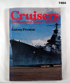
Book - BOOK, NAVAL, Antony PRESTON, "Cruisers- An Illustrated History 1880 -1980", 1980
Hard cover book with dust cover. Hard cover - cardboard with Navy Blue buckram cover. Gold print on spine. Dust cover - paper, red and black print on front, spine, front and back flaps. Illustrated, front cover photograph in colour of a ship dockside. Back cover - photograph in colour of a portion of a ship in a seascape of water, sand and trees in background. 191 pages, cut, plain, white paper. Illustrated in black and white and colour photographs, maps and technical illustrations. Front end paper - handwritten greeting.Front endpaper - blue pen - handwritten, "TO DAD/ FROM VALERIE & IAN - FATHERS DAY 1981". books, navy cruisers -
 Bendigo Military Museum
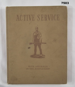
Book - BOOK, WW2, The Military History & Information Section AIF (Middle East), "ACTIVE SERVICE WITH AUSTRALIA IN THE MIDDLE EAST", 1941
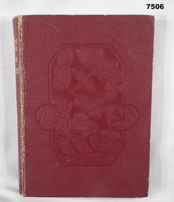
Refer Cat No. 7504, 7505, 7506, 4 book collection.Hardcover book. Cover - cardboard, with light brown buckram cover with dark brown print on front and spine. Illustration in dark brown - soldier in silhouette. End papers - illustrated brown and cream colour tones - maps back and front, 128 pages - cut, plain, cream colour paper, illustrated colour, black and white and sepia illustrations, photographs, paintings.books, army, ww2 -
 Bendigo Military Museum
Book - BOOK, WW2, The Sun News - Pictorial, "THE FOURTH YEAR OF WAR IN PICTURES", 1944
Refer Cat No. 7503, 7504, 7505, 4 book collection.Hard cover book. Cover - cardboard, with red colour buckram cover, gold print on spine and embossed illustrations on front cover depicting map, aircraft and tank. End papers - illustrated, sepia tones artwork with aircraft and landscape battle scene. 255 pages - cut, plain, white paper. Illustrated in black and white photographs, maps and battle diagrams. Handwritten inscription on page opposite Title Page.Page opposite Title Page - handwritten black ink inscription - "Wishing Kevin a/ Merry Xmas/ from/ Nathalie 1944".books, pictorial, ww2. -
 Bendigo Military Museum
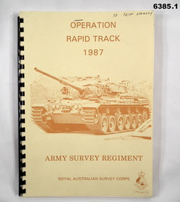
Administrative record - Army Survey Regiment - Operation Rapid Track 1987 Operation Report, Army Survey Regiment, Bendigo, 27 May 1987
... :50,000 map covering the Puckapunyal Military Training Area...:50,000 map covering the Puckapunyal Military Training Area ...The Survey Operation Report deals with the cartographic completion of four 1:50,000 topographical line maps and one Special 1:50,000 map covering the Puckapunyal Military Training Area. The report covers in detail the digital stereo plotting, field completion (checking) and the cartographic completion including printing. The four 1:50.000 maps are 7823-1 PYALONG, 7824-2 COSTERFIELD, 7923-4 TALLAROOK and 7924-3 NAGAMBIE. Annex A lists personnel and dates involved and is attached as 6385.2. Annex B lists the members of the field completion parties.A4 sized buff coloured light cardboard covered report, plastic spiral binding. Front cover includes text, Survey Corps badge and light brown image of a Centurian tank. "To Tech Library", Page 2 has two small handwritten notes indicating that Phase 2 was the Field Completion Phaseroyal australian survey corps, rasvy, fortuna, army survey regiment, army svy regt, asr -
 Bendigo Military Museum
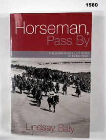
Book - BOOK, WW1, Lindsay Baly, "Horseman, Pass By", 2003
"Horseman, Pass By. The Australian Light Horse in World War 1".Soft cover book. Cover - cardboard, white, red and grey colour print on front, spine and back. Front and back covers illustrated black and white photograph, a mounted division (of soldiers on horseback) march out. 337 pages, cut, plain white paper. Illustrated in black and white photographs, maps and diagrams.books, ww1, light horse -
 Bendigo Military Museum
Map - Australian Topographical Survey NAGAMBIE SW Sheet, 1 inch:1 Mile, NW portion Plane Table Field sheet 1921, Australian Survey Corps, 1921
This is a coloured reproduction print of an original Plane Table compilation map sheet of Nagambie area 1inch to 1 Mile scale compiled by Sgt Jack Cullen Australian Survey Corps 30 September 1921. Jack was one of the foundation members of the Australian Survey Corps. Of particular interest is the fact that this is a heighted compilation with contouring (required for Military use) as many early maps were purely planimetric. A table on the right hand side details the number of days that it took to produce the compilation. The reverse side of this print is a copy of the Tallarook plane table South East field sheet.Reprinted coloured Image of Australian Topographical Survey NAGAMBIE SW Sheet,1 inch:1 Mile, NW portion hand drawn Plane Table Field sheet. Includes an itemized summary of work, signed by Sgt J Cullen Australian Survey Corps September1921.royal australian survey corps, rasvy, fortuna, army survey regiment, army svy regt, asr -
 Bendigo Military Museum
Photograph - Wayzgoose Hall and Speedmaster Printing Press Commissioning, Army Survey Regiment, Fortuna Villa, Bendigo, 1990
The first photograph was probably taken at a media event announcing the introduction of the Heidelberg Speedmaster printing press in late 1990. LTCOL Rene van den Tol was the CO of the Army Survey Regiment from 1989 to 1991. Partly obscured behind the CO was Mr Bruce Reid, who was the newly elected federal member for Bendigo. The media event was held in Wayzgoose Hall, Lithographic Squadron’s new purpose-built building constructed to house the Speedmaster printing press. This occasion is covered in more detail in page 143 of Valerie Lovejoy’s book 'Mapmakers of Fortuna – A history of the Army Survey Regiment’ ISBN: 0-646-42120-4. Refer to Item 6291.6P for more photos of the Open Day.This set of three photographs were taken at the commissioning ceremony of Wayzgoose Hall, the Army Survey Regiment’s new printing building and the Heidelberg Speedmaster Printing Press, at Fortuna Bendigo on Wednesday 27th June 1990. The black & white photographs were printed on photographic paper and are part of the Army Survey Regiment’s Collection. The photographs were scanned at 300 dpi. .1) - Photo, black & white, 1990. Commissioning Ceremony L to R: CO LTCOL Rene van den Tol, Commander 3rd Military District BRIG P. Davies AM ADC, WO2 Jeff Willey in background. .2) - Photo, black & white, 1990. L to R: CO LTCOL Rene van den Tol, Commander 3rd Military District BRIG P. Davies AM ADC with first printed topographic map – 8123 4 Mansfield 1:50 000. .3) - Photo, black & white, 1990. L to R: SGT Gary Kerr in background, Seligson Claire Printing Press Suppliers - Richard Rasmussen and Oliver Holliwell, Bob Martin, Director of Survey COL Don Swiney MBE, RA Svy COL CMDT COL John Hillier, Commander 3rd Military District BRIG P. Davies AM ADC, Bruce Reid Bendigo MHR..1P to .3P – Annotated on back of photos ‘Opening New Print Room BRIG Davies 27 Jun 90’. Personnel and civilians are identified.royal australian survey corps, rasvy, army survey regiment, army svy regt, fortuna, asr, litho -
 Bendigo Military Museum
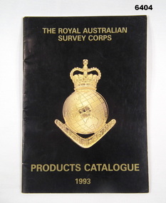
Booklet - PRODUCTS CATALOGUE 1993, RASvy Corps, Royal Australian Survey Corps. Products Catalogue1993, 1993
This Catalogue contains details on the products and capabilities available from the RASvy CorpsA4 Booklet black cover, Survey Corps badge in Gold. Sample maps of all products produced by RASvy Corps 1993rasvy, fortuna -
 Bendigo Military Museum
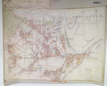
Map - Map of Newcastle NSW 4 Inch - 1 Mile 1910, Australian Intelligence Corps, Nov 1910
In 1909 the Australian Army Headquarters realized that mapping in Australia was either non existent or inadequate for Military use. It was requested that Australia borrow Survey personnel from the UK Royal Engineers (RE) for a two-year detachment. On 11 April 1910 four RE NCOs arrived in Melbourne comprising CPL J Lynch, and LCPLs AH Barrett, EF Davies and R Wilcox. LCPL Barrett had 12yrs experience with RE. They were aiming at producing eight map sheets per year covering about 7,000 square miles (18,000 square Km) This map sheet of the Newcastle area was produced using plane table methods and was surveyed and hand drawn by LCPL A Barrett Oct - Nov 2010. It was unique because it was now produced on an accurate gridded base and included contouring. Lynch and Davies transferred to the Royal Australian Engineers (RAE) whilst Barrett and Wilcox returned to the UK in June 1913. Barrett returned to Australia in 1915 and also enlisted in the RAE and served until 1919.A gridded Map of Newcastle NSW area scale four inches to one mile with 25 feet interval contouring. Coloured hand drawn map produced in 1910. Signed by " A Barrett LCPL Royal Engineers"royal australian survey corps, rasvy, fortuna, army svy regt, army survey regiment -
 Bendigo Military Museum
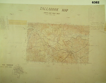
Map - Australian Topographical Survey TALLAROOK SE Sheet, 1 inch:1 Mile, NW portion Plane Table Field sheet 1923, Australian Survey Corps, 1923
This is a coloured reproduction print of an original Plane Table compilation map sheet of Tallarook area 1inch to 1 Mile scale compiled by Sgt Jack Cullen Australian Survey Corps 12 November 1923 and signed by Capt J Lynch. Capt Lynch and Sgt Cullen were both foundation members of the Australian Survey Corps. Of particular interest is the fact that this is a heighted compilation with contouring (required for Military use) as many early maps were purely planimetric. The reverse side of this print is a copy of the Nagambie plane table South West field sheet.Reprinted coloured Image of Australian Topographical Survey TALLAROOK SE field Sheet,1 inch:1 Mile, hand drawn contoured Plane Table Field sheet. Signed by Sgt J Cullen Australian Survey Corps November1923. An enlargement of YEA Township 2 Inches to 1 Mile Scale.royal australian survey corps, rasvy, fortuna, army survey regiment, army svy regt, asr -
 Bendigo Military Museum
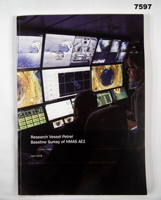
Book, Find AE1 Ltd & Australian National Maritime Museum, "RESEARCH VESSEL PETREL BASELINE SURVEY OF HMAS AE1", 2018
"Research Vessel Petrel - Baseline Survey of HMAS AE1" This book is a report of a comprehensive photographic survey completed on a c.1938 submarine wreck off the coast of PNG.Soft cover book. Cover - cardboard with white print on black and dark blue background on front and spine. Illustrated with colour photographs. Front cover - "RV Petrel control room during the survey". Back cover - "AE1 bow torpedo tube". 179 pages, cut, plain, white paper. Illustrated in black and white and colour photographs, maps and technical drawings.books, ww2, submarine, png, photographic -
 Bendigo Military Museum
Uniform - JACKET, SERVICE DRESS, SUMMER, ARMY, cWW2
Jacket - Khaki colour cotton twill fabric, brown colour Bakelite shank buttons with raised map of Australia and lettering with metal cotton pins. Collar, shoulder epaulettes with attached "AUSTRALIA" badge, two front pockets with button down flap. Inside jacket two brass belt keepers. Manufacturers stamp inside front right side.Manufacturers information - purple ink stamp "^/C.P."uniform, army, cww2 -
 Bendigo Military Museum
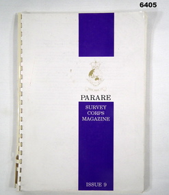
Magazine - "Parare" Survey Corps Magazine Issue 9, Royal Australian Survey Corps, 1993
An annual magazine published for release on RASvy Corps birthday 1st July. All units with RASvy Corps are invited / expected to submit an article depicting their activities over the preceding years 1991 to 1993. 4Fd Svy Sqn Adventure training list pages 7, 8. Army Map Depot - Unit Ski Day, pages 20, 21. The William Patton Expedition - Locating his grave as part of the " Burke and Wills " expedition, list of personnel involved - page 43. 8 Fd Svy Sqn - names mentioned and photo - page 50. 4 Fd Svy Sqn (1992) names mentioned page 69. The G Res manning list on page 70. Names mentioned in "Unit sports pages 73, 74. Exercise Kokoda Cartographer July 1992 list of participants on Page 78. Iraq - The Gulf War, Topographic Support page 52. Adelaide (4 Fd Svy Sqn) 1992 page 65. 8 Fd Svy Sqn manning wind down list pages 89-90. Military Geographic Information Pilot Project page 92. Royal Australian Survey Corps Aerial photography Team personnel list page 95. Operation Belama 92 Team list page 96. Long term Schooling attendees and promotions, page 105. Litho Sqn Postings in and out pages 116-117. Special awards SGT Durrant page 113, SSGT SR Hill page 114. RASvy completes 1:50,000 scale mapping of the Pilbara Region page 121. 1st Topo Svy Sqn personnel mentioned on page 122. A4 sized booklet with soft glossy card covers, paper pages held together with a plastic spiral binder.army survey regiment, army survey regt, fortuna, royal australian survey corps, rasvy, asr -
 Bendigo Military Museum
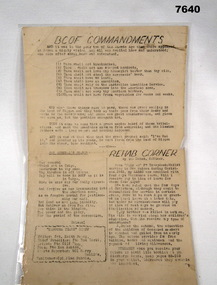
Document - BCOF COMMANDMENTS, C1945 - 1950
Item in the BCOF Association Collection, refer Cat No 7625This is a single page document printed both sides. It has been laminated. Side one - typed wording in black ink. Headlines are:- "BCOF COMMANDMENTS", "THE GENERAL'S PRAYER" and "REHAB CORNER" Side Two - A map showing Japan at the top, Australia at the bottom. It shows the course the ship HMAS MANOORA took to come home. Numbers along the way show 1800 hrs and the day/date at that time.japan, japan occupational forces, hmas manoora -
 Bendigo Military Museum
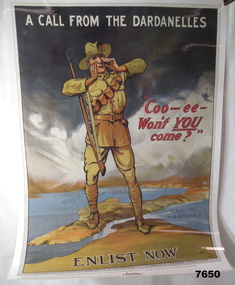
Poster - ENLISTMENT POSTER, St. Leigh & Co. Ltd, Original WW1
A commemorative poster facsimile of an original WW1 Recruitment Poster issued in 1915 by Defence Department - Issued by Australian Geographic.Large hard paper poster. Symbolic image of Australian Soldier standing on a 3D image of the Dardenelles in Turkey. In colour showing map of that part of Turkey. Poster laminated with layer of clear plastic to protect it.On top says "A CALL FROM THE DARDENELLES" On bottom "ENLIST NOW" In middle "COO-EE - WON'T YOU COME"ww1, recruitment poster -
 Bendigo Military Museum
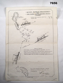
Map - BATTLE MAP - SYDNEY EMDEN, Possibly 1928
This is a medium size poster. It is drawn in black ink. It shows an image of HMAS SYDNEY, SS BURESK (Collier) and SMS EMDEN. It shows the tracks the two ships took through the battle. It shows dotting lines throughout the drawing - possibly indicating when shots were exchanged. It shows a list in the centre, showing basic specs of the two warships and their battle casualties. It also shows relative positions of Keeling Island and Direction Island.ww1, sms emden, hmas sydney -
 Bendigo Military Museum
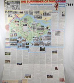
Poster - POSTER RE THE FALL OF SINGAPORE AND MALAYA
See Cat 7656This is a very large poster with coloured printing in red, blue and black ink. One side is titled "The surrender of Singapore". Both sides have maps and photos.ww2, poster, fall of malaya, fall of singapore -
 Bendigo Military Museum
Map - MAPS, EAST TIMOR, US Govt et al, 1975 - 1976
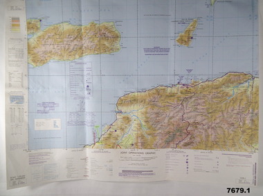
1. This is a coloured map. It's scale is 1.250,000 - called a jpoint operations graphic. It covers the North side of East Timor. Dili is in the centre. Its shows 4 Islands to the north of Timor. It shows Savu Fea, Ombai Strait, Wetar Strait. On bottom left of map it shows Batheade and the start of the New Border. Map - Series 159. Sheet 5C- 51-4. Edition 3-GSGS. 2. This is a coloured map. Its scale is 1.250,000 called a joint Operations Graphic. It manly covers West Timor. It shows Savu Sea in North and Timor Sea on south side. Series 1501. Sheet SC 51.7. Edition 3-GSGS. 3. This a coloured map. It's scale is 1.250,000. Joint operations graphic. This map shows the south side of East Timor and the Timor Sea. This map shows a highlighted New border. The major towns on South coast are KAMFNASA, BETANO. Map series 1501. Sheet SC 51-8. Edition 3 GSGS.1. Has highlighted "7 BSG" on coast. All maps show East Timor border highlighted in pink.east timor, maps, interfet -
 Bendigo Military Museum
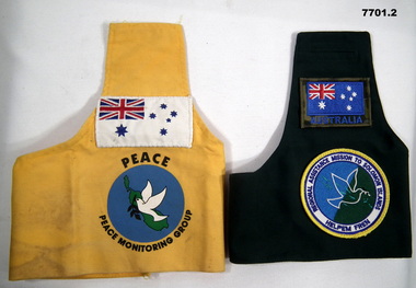
Uniform - BRASSARDS, PEACEKEEPER
Brassards were worn by Peacekeeping Forces to identify their identity. Belonged to Gary Clift R.127835 M8073771. For RAMSI was deployed as ship's company HMAS BRUNEI. For PNG was deployed from HMAS TARAKAN & BRUNEI.1. PNG Peace Keeping Mission Brassard. Bright yellow brassard. Stitched on white Australian ensign on arm picture of dove carrying a twig overlaid over a map of Bougainville in green. Blue background. 2. RAMSI brassard for Solomon Island Peace Keeping Mission. Dark green with Australian Flag sewn onto sleeve. As is RAMSI emblem (yellow border, white dove over map os islands).1. Embroidered "Peace" & "Peace Monitorial Group". 2. Embroidered patch "Regional Assistance Mission to Solomon Islands" and "Helpen Frew".peace keepers, uniform, brassards, ramsi -
 Bendigo Military Museum
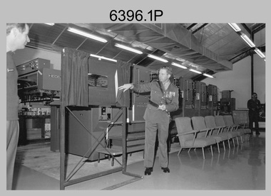
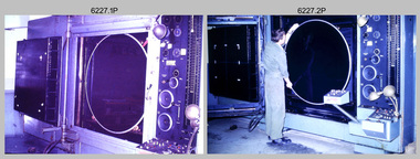
Photograph - Photographic Technicians operating the KLIMSCH Camera at the Army Survey Regiment, Fortuna, Bendigo, c1988
These nine photographs were most likely taken in c1988 in Lithographic Squadron at the Army Survey Regiment, Fortuna, Bendigo. The equipment operated by the technicians is the KLIMCH camera. The main tasks undertaken by the technicians were most likely enlargements and reductions of map reproduction material. The KLIMSCH Commodore camera was introduced in 1953 and was the largest in the Southern Hemisphere. It was replaced with a new model of the same size in 1979. The new model with its computer-based interface provided productivity gains with improved speed and its consistent results led to less wastage in time and materials. Its variomat lens system provided improved retention of map feature linear weights during the camera reduction process. The camera which was specially made for the Army in Germany was fully automatic and power operated. It was claimed to be one of the biggest automatic cameras of its type in the world. It was made to the specifications of the Royal Australian Army Survey Corps to assist in the production of the very high standard maps for the Army. There are several more photos catalogued in the Victorian Collections database of RA Svy personnel operating the KLIMSCH camera.This is a set of four photographs of technicians operating the KLIMSCH Camera at the Army Headquarters Survey Regiment, Bendigo c1988. The photographs are on 35mm colour slides scanned at 96 dpi. They are part of the Army Survey Regiment’s Collection. .1) - Photo, colour, c1988, KLIMSCH Camera. .2) - Photo, colour, c1988, KLIMSCH Camera, unidentified technician. .3) - Photo, colour, c1988, KLIMSCH Camera. .4) - Photo, colour, c1988, KLIMSCH Camera, L to R: SPR Shona Hastie, CPL Paul Baker. .5) - Photo, colour, c1988, KLIMSCH Camera. .6) & .7) - Photo, colour, c1988, KLIMSCH Camera, SPR Shona Hastie. .8) & .9) - Photo, colour, c1988, KLIMSCH Camera, SPR Russell Pajank.35mm colour slides are in good condition.rasvy, royal australian survey corps, army survey regiment, army svy regt, fortuna, asr, litho sqn