Showing 85 items matching "parish of south melbourne"
-
 City of Moorabbin Historical Society (Operating the Box Cottage Museum)
Document - Genealogy Chart Henry Dendy (Photocopy), 19 thC
In 1840 Henry Dendy, a farmer in Surrey, England acquired a "Special Survey" from the Commissioners for Land and Emigration which gave Dendy the right to choose land in Port Phillip for the "bargain basement" price of only £1 per acre for 5120 acres, (an area of 8 square miles). The Special Survey also included the right to "the shipment of a worker for every £20 spent on land, whose free passage was paid by the Crown, equalling a total of 100 workers ". Accordingly Dendy sold his English holdings and paid the required £5120 and arrived in Melbourne in February 1841. However by this time land in the new colony was selling for £5 - £40 per acre. Because Henry Dendy possessed the order from the Colonial Office in London he was able to successfully oppose Super-intendant LaTrobe's attempts to alter the price of the land. Dendy appointed Jonathan Were, (an entrepreneur, who had arrived in 1839), as his Manager and who later became a partner. Together, Dendy and Were decided on an area 5 miles south from Melbourne, bounded by North Road, East Boundary Road, South Road and to the west by Port Phillip Bay. Were and Dendy pitched their tents in the area now known as ' Park St, Brighton' and sank a well near the corner of 'St Andrew's St and Wells St'. By 1845 J.B Were and Company had bought almost half of Dendy's land and Were built himself "Moorabbin House" in Were St Brighton made from stone, quarried from local cliffs. It was still standing in 1924. Legend records Moorabbin is named after the Aboriginal word for ' Mother's Milk ' The soil is very fertile and well supplied with water especially in the area called 'East Brighton' - now known as Bentleigh and East Bentleigh - By 1850 the area had developed with numerous market gardens, dairy farms, fruit gardens and vineyards supplying food for the growing population of Melbourne.In 1840 Henry Dendy, a farmer in Surrey, England acquired a "Special Survey" from the Commissioners for Land and Emigration which gave Dendy the right to choose land in Port Phillip for the price of only £1 per acre for 5120 acres. This land was called Brighton in the Parish of Moorabbin, County of Bourke and emigrants developed the land establishing market gardens , dairy and poultry farms that provided the food for the growing population of Melbourne. A photocopy of the Genealogy Chart of the Dendy Family that Henry Dendy brought with him when he emigrated to Melbourne 1841Genealogy signs and descriptionsdendy henry, dendy's special survey brighton 1841, governor gipps, captain lonsdale, super-intendant latrobe, port phillip, melbourne, new south wales, squatters, emmigrants, county of bourke, parish of moorabbin, early settlers, pioneers, market gardeners, dairy farmers, fruit farms, moorabbin, bentleigh, brighton, cheltenham, were jonathan binn, -
 City of Moorabbin Historical Society (Operating the Box Cottage Museum)
Document, Henry Dendy family Shield
In 1840 Henry Dendy, a farmer in Surrey, England acquired a "Special Survey" from the Commissioners for Land and Emigration which gave Dendy the right to choose land in Port Phillip for the "bargain basement" price of only £1 per acre for 5120 acres, (an area of 8 square miles). The Special Survey also included the right to "the shipment of a worker for every £20 spent on land, whose free passage was paid by the Crown, equalling a total of 100 workers ". Accordingly Dendy sold his English holdings and paid the required £5120 and arrived in Melbourne in February 1841. However by this time land in the new colony was selling for £5 - £40 per acre. Because Henry Dendy possessed the order from the Colonial Office in London he was able to successfully oppose Super-intendant LaTrobe's attempts to alter the price of the land. Dendy appointed Jonathan Were, (an entrepreneur, who had arrived in 1839), as his Manager and who later became a partner. Together, Dendy and Were decided on an area 5 miles south from Melbourne, bounded by North Road, East Boundary Road, South Road and to the west by Port Phillip Bay. Were and Dendy pitched their tents in the area now known as ' Park St, Brighton' and sank a well near the corner of 'St Andrew's St and Wells St'. By 1845 J.B Were and Company had bought almost half of Dendy's land and Were built himself "Moorabbin House" in Were St Brighton made from stone, quarried from local cliffs. It was still standing in 1924. Legend records Moorabbin is named after the Aboriginal word for ' Mother's Milk ' The soil is very fertile and well supplied with water especially in the area called 'East Brighton' - now known as Bentleigh and East Bentleigh - By 1850 the area had developed with numerous market gardens, dairy farms, fruit gardens and vineyards supplying food for the growing population of Melbourne. dendy henry, dendy's special survey brighton 1841, governor gipps, captain lonsdale, super-intendant latrobe, port phillip, melbourne, new south wales, squatters, emmigrants, county of bourke, parish of moorabbin, early settlers, pioneers, market gardeners, dairy farmers, fruit farms, moorabbin, bentleigh, brighton, cheltenham, were jonathan binn, -
 Eltham District Historical Society Inc
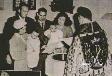
Photograph, A Baptism, conducted by the Reverend David Warren (1956-1960) wearing vestments, Vicar of St Margaret's, c.1960. The font is located in the south-east corner of the church
Digital scan of photograph - Original Source Copy: St Margaret's Parish Archives. church of england, churches, eltham, st margarets church, reverend david warren -
 Glen Eira Historical Society
Article - REGENT LODGE, REGENT STREET, 46, ELSTERNWICK
This file contains 10 items about the Regent Lodge Extension Appeal: 1/Three promotional pamphlets, all called ‘Regent Lodge: A special kind of care’, stating that a building appeal will be launched early next year. The pamphlets also list office bearers. 2/A letter from Rodney Horsfield, Chairperson of the Project Working group, to Betty Freeland of the Elsternwick-Caulfield South Parish, dated 25/03/1992, asking for her to consider becoming a member of the Appeal Team. The letter also contains information on the history of Regent Lodge, the plans for development and progress on raising funds to date. 3/A letter from Ian Clark, Chairman of the Regent Lodge Extension Appeal, to Betty Freeland, dated 18/05/1992, inviting her to the official launch of the Regent Lodge Extension Appeal at Caulfield Grammar School, 217 Glen Eira Road Caulfield on 31/05/1992. The letter gives brief details on the launch, saying it will be attended by the appeal’s patron, the Honourable Joan Child, AO, and the Playback Theatre company. 4/A letter, recipient and sender unknown, dated 26/05/1992, giving details of the appeal launch and a brief history of Regent Lodge. 5/Two newspaper articles from the Southern Cross, Caulfield, dated 16/06/1992. The first, ‘Grant boost for dementia sufferers’, discusses a federal government grant of $8 million to dementia services, and $9 million to disability services. Heathlands, Camden Court, Lovell House, Clarence Court, Regent Lodge and St. Kilda House all received funds. The second, ‘Lodge building appeal launched’, describes the Regent Lodge Extension Appeal and its launch, and includes brief comment by appeal patron Joan Child. The article describes the plans for the appeal and extension, and outlines how readers can make donations. Included is a black-and-white photograph of Joan Child with members of the Playback Theatre Group at the Appeal Launch. 6/The original of the photograph used in the newspaper article in item 5, showing Joan Child with members of the Playback Theatre Group at the launch of the Regent Lodge Extension Appeal. 7/A letter from Rod Horsfield, Convenor of the Project Working Group, to Betty Freeland, dated 22/06/1992, discussing the launch and asking for the opportunity to meet with her Parish council or Finance Committee. 8/The plans for the extension of Regent Lodge, as well as a colour drawing of what the front of the extension will look like. 9/Preliminary photographs taken for the appeal brochure ‘Regent Lodge: Committed to Caring’. Twelve black-and-white photographs of two elderly residents at tea. Also, one black-and-white photographs of an elderly resident being assisted by another person, likely a staff member. 10/Three copies of the appeal brochure ‘Regent Lodge: Committed to Caring’. The brochure contains information about the lodge, the plans for the development, including a floorplan for a typical six bedroom unit, the costs of the extension and breakdown of how the appeal target amount would be spent, and messages from patron Joan Child, Appeal Committee Chairman Ian Clark, and Convenor of the Project Working Group Reverend Rod Horsfield. Also included is a list of the members of the Appeal Committee and Project Working Group. Black-and-white photographs of residents and workers at the Lodge are included in the brochure.regent lodge, regent street, elsternwick, emma street, caulfield south, heathlands, camden court, lovell house, st. kilda house, balaclava, caulfield grammar school, glen eira road, st. georges road, caulfield, uniting church, uniting church lodge program, regent lodge alzeimer appeal, regent lodge extension appeal, tansley hunt and partners, nepean presbytery, child joan the honourable, horsefield rod rev., horsfield rod rev., horsfield rodney rev., lukies noela mrs., campbell jack, cardell bob, davies gail mrs., greensmith duncan, tansley vern, merrick ruth ms., seccull barbara ms., freeland betty miss, clark ian, wilcox rosemary mrs., coleman julie, playback theatre company, martens veronica mayor, brown george, terrell tom, diseases, disabled people, nursing homes, fundraising events, aged people -
Glen Eira Historical Society
Document - COATESVILLE UNTING CHURCH CORNER NORTH AND MACKIE ROAD
Two items about this church: 1/Photocopied details of the Church’s preliminary stages of development at Coatesville Uniting Church. 2/Photocopied article with brief details of Coatesville parish history which includes East Bentleigh Presbyterian and South Oakleigh Methodist parishes.south oakleigh methodist church, reid a, north road, coatesville uniting church, bray mr, mackie road, harris mr, phillips l.g. rev, okey mr, adams mr, williams w.j. rev, murrumbeena, harris mr, iliffe w.r, hallibone mr, fielding mr, reynolds mr, nancarraw mr, reic a mr, thomas miss, winter mr, lanym a. mr, sturgess h mr, sturgess mrs, duncan annie, duncan gordon, sturgess edith, evans chas, ralton mr, architects, coatesville parish, uniting church, east bentleigh presbyterian church, cecil street, peerman alex rev, east bentleigh presbyterian, market gardens, st christopher’s church, bell a.f. rev, body alan rev, jassa street, manses, trevorrow mr, halls, sunday schools, bentleigh east -
 Federation University Historical Collection
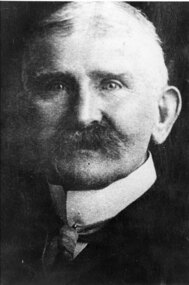
Photograph - Photograph (black & white), Ferdinand Moritz Krause
Civil engineer and geologist Ferdinand Moritz Krause lecturered at the Ballarat School of Mines from 1880 to 1895. He was born at Kassel, Germany on 24 February 1841, the youngest son of Frederich Wilhelm Krause. Ferdinand Krause married Amy Augusta Dimock. He died in South Africa 16 June 1918. In June 1880 Krausé was appointed to the Ballarat School of Mines as lecturer in 'geology, palaeontology, mineralogy, electricity, magnetism, scientific mining, geological and topographical surveying' and as museum curator. In 1881 he was appointed Professor of Geology and in 1892 was elected president of the Staff Association. He was held in high repute by his students and also known as a keen musician. He resigned from the School of Mines to be lecturer in mining at the University of Melbourne from June 1895 to January 1897. Whilst at Ballarat in 1887-90 he had completed geological maps and reports on the parishes of Haddon, Carngham, Scarsdale, Lillerie, Smythesdale and Comeralghip; these were published in 1898. The Institute of Surveyors elected him a member in 1891. His Introduction to the study of Mineralogy for Australian readers was published in Melbourne in 1896. In January 1897 he became manager of the General Gordon mine near Kalgoorlie. In 1900 he contributed an article to the Ballarat School of Mines Students' Magazine on the mining geology of Kalgoorlie. Invited by a former student, George Denny, Krausé left for South Africa in 1901. His last work was a geological map of the Barberton area, Transvaal, published in March 1918. He died on 16 June, survived by his wife, three sons and a daughter. (http://adb.anu.edu.au/biography/krause-ferdinand-moritz-3971, accessed 20 November 2018) Black and White photograph of the head and shoulders of Professor Ferdinand Krause of the Ballarat School of Mines.ballarat school of mines, ferdinand krause, geology, fm krause, krause, ballarat school of mines museum -
 Ringwood and District Historical Society
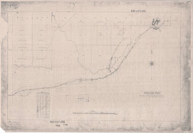
Map, Road Plan 108 - Gipps-land Road, Parishes of Bulleen and Warrandyte (Ringwood, Victoria) - 1855
Surveyor's map of the part of the main road from Melbourne to Gippsland following "Barker's Track" south of Mullum Mullum or Deep Creek. Map references include Roman numerals marking distances measured in Links between trees at turns in the road.Submitted to the Surveyor General (Signed) July 2nd 1855. -
 City of Moorabbin Historical Society (Operating the Box Cottage Museum)
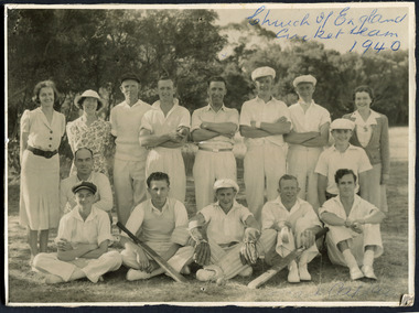
Photograph, Black & White, St Matthew's Church of England Cricket Team c 1940, c1940
The Cheltenham parish was created in 1865 by excising a portion of the parish of St Andrews Brighton. A small brick church was completed in 1867 to serve a rural community stretching from Brighton South (Moorabbin) to Mordialloc. 1867 St Matthew's Church of England was erected in Cheltenham beside the Nepean Highway near Charman Road. The early settlers established a tennis club, cricket team and social groups.St Matthew's Church of England Cheltenham was erected in 1867 and was integral to the spiritual well being and social life of the early settlers.Black & White photograph of the St Matthews Church of England Cricket team Cheltenham c 1940Front ; Church of England Cricket Team 1940 Back ; Written - Ladies / Hilda Biehl, Bertha Schneeberber, Mrs Wootton, / We made afternoon tea from / a kerosene tin for 30 players / each Saturday they played at home !!smith j l; smith mary ann, stanley helen, chaff cutter, horse drawn carts, toll gates brighton, motor cars 1900, steam engines, early settlers, bentleigh, parish of moorabbin, city of moorabbin, county of bourke, moorabbin roads board, shire of moorabbin, henry dendy's special survey 1841, were j.b.; bent thomas, o'shannassy john, king richard, charman s, highett william, ormond francis, maynard dennis, market gardeners, vineyards, orchards, -
 City of Moorabbin Historical Society (Operating the Box Cottage Museum)
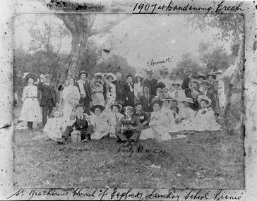
Photograph - St Matthew's Church of England Sunday School Picnic 1907, 1907
The Anglican Cheltenham parish was created in 1865 by excising a portion of the parish of St Andrews Brighton. A small brick church was completed in 1867 to serve a rural community stretching from Brighton South (Moorabbin) to Mordialloc. 1867 St Matthew's Church of England was erected in Cheltenham beside the Nepean Highway near Charman Road. The early settlers established a tennis club, cricket team and social groups. A typical social event was the annual Sunday School Picnic held in 1907 at Dandenong Creek.Young members are mentioned Curly Owen,C,Burnett,A Manett St Matthew's Church of England Cheltenham was erected in 1867 and was integral to the spiritual well being and social life of the early settlers.Black & White photograph of the St Matthew's Church of England Sunday School Picnic 1907Handwritten Curly Owen, C, Burnett, A Manett st. matthew's church of england cheltenham, sunday school picnics, anglican church, st andrew's church brighton, owen curly, burnett c . manett a, horse drawn carts, toll gates brighton, motor cars 1900, steam engines, early settlers, bentleigh, parish of moorabbin, city of moorabbin, county of bourke, moorabbin roads board, shire of moorabbin, henry dendy's special survey 1841, were j.b., bent thomas, o'shannassy john, king richard, charman stephen, highett william, ormond francis, maynard dennis, market gardeners, vineyards, orchards -
 City of Moorabbin Historical Society (Operating the Box Cottage Museum)
Clothing - Clothing, City of Moorabbin Tie, Circa 1960s
The City of Moorabbin existed from 1934 until 1994. Henry Dendy's Special Survey in 1841 of 5,120 acres in the Parish of Moorabbin , extended from Port Phillip Bay , then East to Boundary Road, South to South Road and North to North Road and became known as Brighton. 1859 Brighton became a Borough with its boundary Thomas Street ,and Bluff Road. In 1862 The Moorabbin Roads Board was formed and the extended area now included Cheltenham, Hampton, Sandringham, Black Rock, Beaumaris, Mentone and Mordialloc .and Little Brighton became known as Bentleigh. In 1871 the area became known as The Shire of Moorabbin. Gradually the area was separated into The Borough of Sandringham 1917, ( Black Rock, Beaumaris , Sandringham and Hampton ) Borough of Mentone and Mordialloc 1920, ( Parkdale ). In 1934 The City of Moorabbin was established for the area from South East corner of Thomas Street and North Road , East to Warrigal Road, Clayton Road, Kingston Road , Lower Dandenong Road, then South along Nepean Highway to Balcombe Road and along Bluff Road, Cummins Road, Nepean Highway, Thomas Street to North Road In the 1994 Amalgamation of Councils the City of Moorabbin was divided between the new City of Kingston in the South ( from South Road) and the new City of Glen Eira to the North . It was the largest Municipality in Victoria with a population of 118,865 in 1974This tie c 1960 is a memento of the City of Moorabbin 1934 - 1994Maroon colour, polyester, man's tie with the crest of City of Moorabbin woven on front.around circle enclosing Coat of Arms ; CITY OF MOORABBIN city of moorabbin, moorabbin roads board, moorabbin, brighton, dendy's special survey 1841, early settlers, pioneers, market gardners, dendy henry, were jonathan b, cheltenham, bentleigh, mentone, sandringham, mair william, bent thomas -
 City of Moorabbin Historical Society (Operating the Box Cottage Museum)
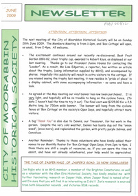
Newsletter, City of Moorabbin Historical Society Feb 2009, February 2009
The City of Moorabbin Historical Society was formed c 1960 by a group of Moorabbin residents who were concerned that the history of the area should be preserved. A good response to a call for items related to the historical area of Moorabbin Shire brought donations of a wide variety of artefacts which are now preserved by the current members of CMHS at Box Cottage Museum . Helen Stanley, Secretary of CMHS, began producing a Newsletter for members in April 2007 to provide current information and well researched items of historical interest.Helen Stanley has produced a bi-monthly Newsletter, 2007 - 2013, for the members of the City of Moorabbin Historical Society that contains well researched interesting historical items, notification of upcoming events, current advice from Royal Australian Historical Society , Museums Australia Victoria and activities of Local Historical Societies. The Newsletter is an important record of the activities of the CMHS. Tom Sheehy, past President of CMHS, was an Historian and Author of ‘Battlers Tamed the Sandbelt’. 2 x A4 paper printed on 3 sides Issue 10 of the bi-monthly, City of Moorabbin Historical Society Newsletter produced by Society member and Secretary, Mrs Helen Stanley in February 2009. The Victorian Bushfire tragedy around Marysville is still unfolding as this Newsletter is written. The first meeting for the year is February 22nd and subscriptions are due. An excerpt is transcribed from the City of Moorabbin Historical Society Newsletter October 1962, “A Piece of History in Ormond” by an unknown eyewitness author, describing the original “Box Cottage” situated in Mr J. Reitman’s cement products factory at 306 Jasper Road, Ormond prior to demolition. The current Editor gives information obtained from further recent research . An Article by Tom Sheehy, past President and Historian, February 1979 “The Vineyards of Moorabbin”. The ‘Brighton Estate” began when Henry Moor brought Vine cuttings from Camden NSW 1848 and they were productive after 3 years. Many Vineyards then appeared from Port Phillip Bay to East Boundary Road and produced 2/3 of the annual Victorian grape crop. Disease or insect caused failure in1858 and the land reverted to market gardens. A coloured photocopied photo of Box Cottage 2005. CITY of MOORABBIN HISTORICAL SOCIETY / FEBRUARY 2009 NEWSLETTERcity of moorabbin historical society, stanley helen, sheehy tom, melbourne, moorabbin, brighton, cheltenham, ormond, bentleigh, vineyards, fruit growing, vine diseases, winemaking, grapes, market gardeners, pioneers, early settlers, moorabbin shire, box cottage museum, dairy, port phillip bay, brighton estate, moor henry, cambden estate, reitman j., reitman w., cement, pottery, jasper road ormond, east boundary road brighton, dendy’s special survey 1851, point nepean road, south road brighton, thomas street brighton, north road brighton, county of bourke, box h., box william, bruton william, brighton brewery, parish of moorabbin, parish of prahran, markets, shingle roof, weather-board, downward mr., mckinnon -
 City of Moorabbin Historical Society (Operating the Box Cottage Museum)
Newsletter, City of Moorabbin Historical Society Apr 2009, April 2009
The City of Moorabbin Historical Society was formed c 1960 by a group of Moorabbin residents who were concerned that the history of the area should be preserved. A good response to a call for items related to the historical area of Moorabbin Shire brought donations of a wide variety of artefacts which are now preserved by the current members of CMHS at Box Cottage Museum . Helen Stanley, Secretary of CMHS, began producing a Newsletter for members in April 2007 to provide current information and well researched items of historical interest.Helen Stanley has produced a bi-monthly Newsletter, 2007 - 2013, for the members of the City of Moorabbin Historical Society that contains well researched interesting historical items, notification of upcoming events, current advice from Royal Australian Historical Society , Museums Australia Victoria and activities of Local Historical Societies. The Newsletter is an important record of the activities of the CMHS.2 x A4 paper printed on 4 sides Issue 11 of the bi-monthly, City of Moorabbin Historical Society Newsletter produced by Society member and Secretary, Mrs Helen Stanley in April 2009. Notice that Mr Travis Sellars, Friends of Cheltenham and Regional Cemeteries, will talk about ‘The Tragic 20’s’ at the meeting April 26th . Volunteers are needed to show visitors around on Open Days each month and a Roster will be made on April 26th . Suggestions are requested for the Community Grant Application to be submitted by CMHS. Historical details are condensed from ‘ The Living Harvest’ by W.T Dobson, describing the establishment of St. Peter’s Catholic School East Bentleigh 1865 on land donated by Fred Quinn , in Centre Road, East Brighton ( East Bentleigh). A photo copy of Parts of Country Portion 39 of Dendy’s Special Survey or Brighton Estate showing the Land Sales of Lot 2, & 3 North Road and Jasper Road 1841 – 1869. Interesting note on the origin of ‘Jasper Road’. 3 photocopied photographs of St Peter’s School building 1903, School Children at East Brighton Railway Station, 1903, A Lorry in the parade 1903. CITY of MOORABBIN HISTORICAL SOCIETY / APRIL 2009 NEWSLETTERcity of moorabbin historical society, stanley helen, dobson w.t., melbourne, moorabbin, brighton, friends of cheltenham and reional cemeteries, cheltenham, ormond, bentleigh, market gardeners, irish immigrants c1850pioneers, early settlers, moorabbin shire, box cottage museum, port phillip bay, brighton estate, jasper road ormond, east boundary road brighton, dendy’s special survey 1851, point nepean road, south road brighton, thomas street brighton, north road brighton, county of bourke, box h., box william, parish of moorabbin, parish of prahran, markets, shingle roof, weather-board, mr., mckinnon, were jonathan, niall rev. fr. patrick, quinn fred, elsternwick, catholic church directory 1878, hibernian society melbourne, brady peter., kennedy mr., boland mr., leary mr., gahan mr., archbishop carr, rev. fr. gough., presentation convent gardenvale, sister mary vincent, charlston john, bavarian dress band, hales jasper -
 City of Moorabbin Historical Society (Operating the Box Cottage Museum)
Newsletter, City of Moorabbin Historical Society June 2009, June 2009
The City of Moorabbin Historical Society was formed c 1960 by a group of Moorabbin residents who were concerned that the history of the area should be preserved. A good response to a call for items related to the historical area of Moorabbin Shire brought donations of a wide variety of artefacts which are now preserved by the current members of CMHS at Box Cottage Museum . Helen Stanley, Secretary of CMHS, began producing a Newsletter for members in April 2007 to provide current information and well researched items of historical interest.Helen Stanley has produced a bi-monthly Newsletter, 2007 - 2013, for the members of the City of Moorabbin Historical Society that contains well researched interesting historical items, notification of upcoming events, current advice from Royal Australian Historical Society , Museums Australia Victoria and activities of Local Historical Societies. The Newsletter is an important record of the activities of the CMHS. Jasper Hale , transported for theft, earned his ‘Ticket of Leave, and purchased land in Dendy’s Special Survey of 1841 later known as East Bentleigh. 2 x A4 paper printed on 3 sides Issue 12 of the bi-monthly, City of Moorabbin Historical Society Newsletter produced by Society member and Secretary, Mrs Helen Stanley in June 2009. Notices of the meeting June 28th , an article in ‘The Leader’ newspaper about the Robert Keys ‘Best Fruit Garden 1881 - 82’ Trophy Cup , a large vinyl banner purchased with Grant money, and while acknowledging the Cottage garden volunteer a request for more helpers at Open Days is made. Jan Rigby, CMHS member, has provided research information about Jasper Hale b 1805 in Gloucester, England, transported to NSW 1830, ‘freed man ‘ 1839, purchased land in Dendy’s Special Survey 1844, sold this land 1846 and died 1884 in Parkes NSW. On arrival as a convict in 1830 his occupation is bricklayer and he can ‘ read and write’. CITY of MOORABBIN HISTORICAL SOCIETY / JUNE 2009 NEWSLETTERcity of moorabbin historical society, stanley helen, rigby jan, melbourne, moorabbin, brighton, cheltenham, ormond, bentleigh, market gardeners, pioneers, early settlers, moorabbin shire, box cottage museum, jasper road ormond, dendy’s special survey 1851, north road brighton, county of bourke, box h., box william, parish of moorabbin, were jonathan, hales jasper, port jackson penal colony, burgess s. william, kemble wiltshire england, stonemason, bricklayer, ‘york’ sailing ship, brummell mary, st. mary’s catholic church sydney, nelson mary ann, ‘george hibbert’ sailing ship, hale james, hale eliza, parkes new south wales gold rush, ballarat gold rush, clunes gold rush, forbes nsw gold rush, parkes historical society -
City of Moorabbin Historical Society (Operating the Box Cottage Museum)
Newsletter, City of Moorabbin Historical Society Feb 2012, February 2012
The City of Moorabbin Historical Society was formed c 1960 by a group of Moorabbin area residents who were concerned that the history of the area should be preserved. A good response to a call for items related to the historical area of Moorabbin Shire brought donations of a wide variety of artefacts which are now preserved by the current members of CMHS at Box Cottage Museum . Helen Stanley, Secretary of CMHS, began producing a Newsletter for members in April 2007 to provide current information and well researched items of historical interestHelen Stanley has produced a bi-monthly Newsletter, 2007 - 2013, for the members of the City of Moorabbin Historical Society that contains well researched interesting historical items, notification of upcoming events, current advice from Royal Australian Historical Society , Museums Australia Victoria and activities of Local Historical Societies. The Newsletter is an important record of the activities of the CMHS. 6 x A4 paper printed on 1 side Issue 25 of the bi-monthly, City of Moorabbin Historical Society Newsletter produced by Society member and Secretary, Mrs Helen Stanley in February 2012. Notice of meeting February 26th, subscriptions are due, reminder to all members to encourage visitors to ‘sign in’, offer all children the ‘Treasure Hunt Quiz’ cards, and to complete the Volunteer Hours Record Book. Members are asked to help on the monthly Roster for Open Days. Unfortunately Jim Dale, President, found a disposable lighter and water bottle and at the working bee members found a ‘bong’, so Glen Eira Property Manager, Amanda Mills was notified. Thankfully there was no damage to our property. As May 2012 will be the 150th Anniversary of ‘The Moorabbin Roads Board’, Ms Elizabeth Triarico, Glen Eira CC History & Heritage , has requested a CD of photos, which has been sent, and Ms Suzanne Snooks, Arts & Culture Manager Kingston CC, invited CMHS to assist with a Celebration of this event. Helen has given a précis of The William Green Family History which has been given to CMHS Library by Ms Denise McAvoy , a descendant CITY of MOORABBIN HISTORICAL SOCIETY / FEBRUARY 2012 NEWSLETTER city of moorabbin historical society, stanley helen, melbourne, moorabbin, brighton, cheltenham, ormond, bentleigh, market gardeners, pioneers, early settlers, the moorabbin roads board 1862, city of glen eira, city of kingston, moorabbin shire, parish of moorabbin, brighton east, south brighton, bent tommy, green william, convicts, convict ship asia, eyre edward john, mair william -
City of Moorabbin Historical Society (Operating the Box Cottage Museum)
Booklet - St John's Church of England, East Bentleigh, The New Church, 1963
St John's Church of England first Church was built by the parish of Bentleigh in 1873. The present site, on the south- east corner of Centre and Tucker Roads, was donated by parishioner named John, in whose honour the new church was named St John’s. Erection of a modest brick and bluestone building began in October 1872, and the first service was held on Sunday, 11 May 1873. In the August 1961 a foundation stone was laid to begin the building of the new Church to meet the demands of the present congregation. It was designed by Gawler, Churcher & Boardman (David Gawler) and the builder was Colin D Mason. St John's Church of England Bentleigh was erected in 1873 and was integral to the spiritual well being and social life of the early settlers.Booklet describing the new church and the history of St John's Church of England, Centre Road, East Benteligh, with photosreligin, church of england, anglican, bentleigh, st john's, centre road, tucker road -
Port Melbourne Historical & Preservation Society
Archive - Port 'n' South Living and Learning Centre, Jul 1990
The centre was one of several community groups established in the mid 1980's. After 1998 when the Baptist Church decided to discontinue the relationship, co-ordinator Julie Allen donated the minutes, brochures, photos and other records to the society.From archive box containing the archives of the Port 'n' South Living and Learning Centre located at the Ross St Baptist church, 1985 to 1998. Also includes item 1207 (various files listed on separate attachment) Refer also to items 1084 and 819. .18 Report on jobs, South Port Parks Parish Mission Program result May to June 1990, 27pp; light blue 2with ultramarine tape bindingeducation, community, education - adult, societies clubs unions and other organisations, religion - baptist church, julie allen, alec babos, christine fensham, jenni evans, south port parks parish mission -
Port Melbourne Historical & Preservation Society
Book, Ian Breward, South Port Parks Parish Mission: 150 Years of Service, 2003
This was written by PMH&PS member Ian BREWARD, who is the archivist for the Uniting Church in Melbourne, and therefore for the Methodist, Congregational and Presbyterian churches. It was launched at the Uniting Church in South Melbourne on 2003.South Port Parks Parish Mission: 150 Years of Service by Ian BREWARD - A history of the congregations and missions. Soft cover, 174 pp, illustrated.religion - uniting church, religion - wesleyan methodist church, religion - primitive methodist church, religion - presbyterian church, ian breward, emily lock, hazel wilson, nancy u'ren nee morris -
Port Melbourne Historical & Preservation Society
Map - Footscray, Public Lands Office, 19 Oct 1857
Map of Footscray, west of Saltwater Creek; south of Hopkins Street, east of Railway and north southern boundary of Botanical Garden reserve.The Township of Footscray, Parish of Cut-Paw-Pawfootscray -
 Port Melbourne Historical & Preservation Society
Document - Newsletter, Holy Trinity Anglican Church, Port Melbourne, Parish Paper, Nov 1973
Newsletter was written for Port Melbourne Holy Trinity Church. Details information about the month of August 1974 for the Church and communicates information to parish goersMonthly parish newsletter for the month of November 1973 for Holy Trinity Church, Port Melbournereligion - anglican (holy trinity), deaths and funerals, donald arthur langford, lewis j mullin, archibald h carmichael, glynn e g marshall, phillip lawson, william a woods, elsie j baxter, eliza m aanensen, ernest j mccoll, william h kilpatrick, allan a callick, emily newton-simpson, georgia anita fennessy, robert michael flaherty, raymond bede grzonek, christine carol bath, leanne alderman, returned services league, rsl, sandridge trugo club, south melbourne football club, albert park bowling club, henry molloy, ged muston, w h coffey, george vines, mrs muston, p bedford, c tuncks, john moore, port melbourne bowling club, port melbourne football club, port melbourne cricket club, f mcgorlick, mrs mcgorlick, lions club, w stuckbury, j t mcleod, d jones, g cecil, yvonne margaret kitchen, f a w 'skip' short -
 Bendigo Historical Society Inc.
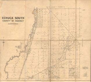
Map - JACK FLYNN COLLECTION: ECHUCA SOUTH, 13/08/1931
... , Melbourne. 13.8.31 Map: Parish of Echuca South, County of Rodney ...Map: Parish of Echuca South, County of Rodney. Parish plan.By Authority H. J. Green, Govt. Printer. Department of Lands and Survey, Melbourne. 13.8.31map, rodney, parish plan, echuca south , county of rodney -
 Bendigo Historical Society Inc.
Map - JACK FLYNN COLLECTION: HUNTLY, 12.03.1932
Map: Township of Huntly, Parish of Huntly , County of Bendigo. Parish plan. Western and South Riding Division on Main St. (Main Northern Highway) - written in ink below name of map.BY Authority H.J. Green. Photo-Lithographed at the Dept., of Lands and Survey, Melbourne. 12.3.32map, bendigo, township, huntly -
 Uniting Church Archives - Synod of Victoria
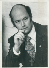
Photograph, Ron Croxford & Peter Mulheisen, 09/1986
The photo was part of the September 24 1986 edition of C&N as the 'cover story', entitled "House of fallen angels", and the article was about Moreland Hall (in 2015 renamed as ReGen) and its work with alcohol and other drug addictions. Croxford was the executive director and Mulheisen the pharmacist at Moreland Hall. The Rev. Ron Croxford had been ordained in 1966, and parishes included Yirrakala (1961-64), Caulfield (1967-68), Mt Waverley (1969-74), Sth & Port Melbourne Mission (1975-77), South-Port-Parks 1977-?Ron Croxford is shown standing by a seated Peter Mulheisen.Their names.croxford, ron, mulheisen, peter, moreland hall (regen) -
 Uniting Church Archives - Synod of Victoria
Photograph, Peter Moonie, 14/08/1985
Reverend Peter Moonie (10/11/1933 - 08/12/2013) was ordained as a Methodist minister in 1961. He served at on King Island and at Launceston South, in the United States at Salem New Hampshire and Agawam Massachusetts, Church of All Nations, Box Hill Regiobnal Parish and Ocean Grove. He retired in 1995.B & W waist length photograph of Rev. Peter Moonie."Peter Moonie C&N 14/8/1985 page 15"moonie, peter, methodist minister -
 Uniting Church Archives - Synod of Victoria
Photograph, Undated c.1985
Reverend Ron Upson was elected unopposed as Moderator of the Tasmanian Synod. Reverend Upson was in 1985 at Launceston South. He was ordained in Western Australia in 1970 and served in three parishes before working in Samoa first at Piula Theological College then as connexional secretary for the Methodist Church in Samoa.Reverend Ron Upson and Reverend J. Pethie seated at a table in front of a church pulpitRev. R. Upson Rev. J. Pethie sheet 1 no 2upson, ron, rev., pethie, j. rev., moderator, synod of tasmania, uniting church minister -
 Uniting Church Archives - Synod of Victoria
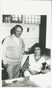
Photograph, Cliff Barclay, 1988
... Melbourne. Cliff Barclay South-Port-Parks Parish Mission Cliff ...Cliff Barclay was a youth worker at the South-Port-Parks parish mission. The church in the background of this photograph is the South-Port-Parks church, Dorcas Street, South Melbourne.B & W waist length photograph of Cliff Barclay, with a bluestone church in the background.Cliff Barclay, youth worker at South-Port-Parks.cliff barclay, south-port-parks parish mission -
 Uniting Church Archives - Synod of Victoria
Photograph, Rev Alan Body, 1988
Rev Alan Body ministered at Wentworth (the Victorian parish in New South Wales) for 10 years, and was subsequently transferred to Boort. During his time at Wentworth he conducted a patrol ministry, travelling between 8000 and 10,000 kilometres per year visiting the area from Wentworth to Pooncarie, to Coombah on the Broken Hill road, out west to the South Australian border, south to the Murray and upstream to Wentworth.B & W waist length photograph of Rev. Alan Body with his Wentworth Shire Australia Day Citizen Award."Alan Body page 31 C&N 24/2/1988"rev alan body -
Whitehorse Historical Society Inc.
Map, Dandenong Ranges Area, 1955
Sheet 13. Parts of Parishes: Nunawading, Mulgrave and Scoresby.Sheet 13. Parts of Parishes: Nunawading, Mulgrave and Scoresby. Includes area of Vermont South marked as proposed Township of Norwich. Scale 10 chains : 1 inch. Contours marked.Sheet 13. Parts of Parishes: Nunawading, Mulgrave and Scoresby. maps, vermont south, wantirna, dandenong creek -
Whitehorse Historical Society Inc.
Map, Plan, 1939
Plan of subdivision, part of crown portion 83A and 83, Parish of Nunawading, County of BourkePlan of subdivision, part of crown portion 83A and 83, Parish of Nunawading, County of BourkePlan of subdivision, part of crown portion 83A and 83, Parish of Nunawading, County of Bourkestreet names, parish of nunawading, station street, blackburn, railway road, blackburn, vine street, blackburn, south parade, blackburn, laburnum street, blackburn, main street, blackburn, gardenia street, blackburn, the avenue, blackburn, fuschia street, blackburn, linum street, blackburn -
Whitehorse Historical Society Inc.
Document, Certificate of Title, 1928, 1933-1934
Certificate of Title, Nanny Schifferdecker.Certificate of Title, Nanny Schifferdecker. Lots 44, 45,56 & 57 subdivision 3360 Crown portion 97 Parish of Nunawading, County of Bourke 1928. Vol 5406 fol 10881070 1928, Agnew and Craig Streets. Also correspondence re rates enforcement charge 1933.Certificate of Title, Nanny Schifferdecker. land titles, shire of blackburn and mitcham, schifferdecker, hanny, craig street, blackburn south, agnew street, blackburn south -
Whitehorse Historical Society Inc.
Document - Newsletter, St Edward's Church of England, 28/02/1966
Newsletter and report of the Annual General Meeting talking about plans to build a Vicarage and the separation of St Edward's Parish and asking for offerings in envelope system.st edward's anglican church, blackburn south, watson, raymond