Showing 107 items
matching plans of former buildings
-
 Eltham District Historical Society Inc
Negative - Photograph, Eltham War Memorial Obelisk 1914-1918, cnr. Main Road and Bridge Street, c.1925
Located on what was referred to as Obelisk Corner, improvements have been been made since the unveiling in August 1919 with the provision of a stone retaining wall topped with a chain link and granite stone boundary, most likely in conjunction with improvements to the intersection into Main Road. Along with the use of the name Obelisk Corner, the Bridge Street bridge was also known as Obelisk Bridge. The Eltham Obelisk was originally located at the corner of Bridge and Main Roads in 1919. In 1943 (WW2) the local community commenced plans to establish the Eltham War Memorial, a living memorial to benefit the children as opposed to a one in stone as per the obelisk. The Eltham War Memorial Trust was established in 1945. In 1947 the Trust intended for the Obelisk to be relocated from Bridge Street and Main Road to the Garden of Remembrance which was planned as part of the Baby Health Centre which was to be the first of three buildings of the Eltham War Memorial to be built in 1951. In 1951 the Eltham RSL was invited to be represented on the Eltham War Memorial Trust. Around this time, with pending roadworks, the obelisk was relocated to the front garden of the Eltham RSL sub branch on Main Road for safe keeping. In 2007, a suggestion was proposed by Harry Gilham (President, EDHS) to John Cohen (ERSL) to claim a special site along with the historic Shillinglaw trees on the now vacant former Eltham Shire Office site adjacent to the Eltham War Memorial precinct for relocation of the obelisk. In 2010 following the financial collapse and sale of the Eltham RSL Sub-Branch property and amalgamation with the Montmorency Eltham RSL sub-branch, the location of the obelisk was again in immediate jepoardy and in conjunction with Nillumbik Shire Council, the obelisk was relocated in front of the Eltham War Memorial buildings in preparation for the Dawn Service on Anzac Day 2012.This photo forms part of a collection of photographs gathered by the Shire of Eltham for their centenary project book,"Pioneers and Painters: 100 years of the Shire of Eltham" by Alan Marshall (1971). The collection of over 500 images is held in partnership between Eltham District Historical Society and Yarra Plenty Regional Library (Eltham Library) and is now formally known as the 'The Shire of Eltham Pioneers Photograph Collection.' It is significant in being the first community sourced collection representing the places and people of the Shire's first one hundred years.Digital image 4 x 5 inch B&W Negsepp, shire of eltham pioneers photograph collection, eltham, main road, eltham war memorial, bridge street, obelisk, obelisk corner -
 Eltham District Historical Society Inc
Photograph, Eltham Shire Office, shortly after duplication of Main Road, c.1968
Eltham Shire Council office built 1964 on the former site of Shillinglaw Cottage. In 1971 the offices were extended with a southern wing (to the left of the building) which housed the Eltham Library and planning offices. Taken shortly after widening of Main Road between Pitt Street and Elsa Court which was undertaken between February 1968 and August 1968. Image was most probably commissioned by Eltham Shire Council and taken by Hugh Fisher, photographer who operated from premises between Arthur and Dudely streets and was often contracted by the shire for official photographic work. The image was used in the August 1971 issue of Australian Municipal Journal This photo forms part of a collection of photographs gathered by the Shire of Eltham for their centenary project book,"Pioneers and Painters: 100 years of the Shire of Eltham" by Alan Marshall (1971). The collection of over 500 images is held in partnership between Eltham District Historical Society and Yarra Plenty Regional Library (Eltham Library) and is now formally known as the 'Shire of Eltham Pioneers Photograph Collection'. It is significant in being the first community sourced collection representing the places and people of the Shire's first one hundred years.Digital image and 120 format B&W negativesepp, shire of eltham pioneers photograph collection, eltham, main road, duplication, road widening, shillinglaw trees, local government -
 Eltham District Historical Society Inc
Photograph, Eltham War Memorial 1914-1918. Cnr. Main Road and Bridge Street, 3 August 1919
Dated 1919, the Eltham Obelisk is decorated with wreaths, most likely for what was originally known as Armistice Day though now known as Remembrance Day, 11 November. The location of the Obelisk at the corner of Bridge Street and Main Road became known as Obelisk Corner and the Bridge Street bridge was also referred to as Obelisk Bridge. The Eltham Obelisk was originally located at the corner of Bridge and Main Roads in 1919. In 1943 (WW2) the local community commenced plans to establish the Eltham War Memorial, a living memorial to benefit the children as opposed to a one in stone as per the obelisk. The Eltham War Memorial Trust was established in 1945. In 1947 the Trust intended for the Obelisk to be relocated from Bridge Street and Main Road to the Garden of Remembrance which was planned as part of the Baby Health Centre which was to be the first of three buildings of the Eltham War Memorial to be built in 1951. In 1951 the Eltham RSL was invited to be represented on the Eltham War Memorial Trust. Around this time, with pending roadworks, the obelisk was relocated to the front garden of the Eltham RSL sub branch on Main Road for safe keeping. In 2007, a suggestion was proposed by Harry Gilham (President, EDHS) to John Cohen (ERSL) to claim a special site along with the historic Shillinglaw trees on the now vacant former Eltham Shire Office site adjacent to the Eltham War Memorial precinct for relocation of the obelisk. In 2010 following the financial collapse and sale of the Eltham RSL Sub-Branch property and amalgamation with the Montmorency Eltham RSL sub-branch, the location of the obelisk was again in immediate jepoardy and in conjunction with Nillumbik Shire Council, the obelisk was relocated in front of the Eltham War Memorial buildings in preparation for the Dawn Service on Anzac Day 2012.This photo forms part of a collection of photographs gathered by the Shire of Eltham for their centenary project book,"Pioneers and Painters: 100 years of the Shire of Eltham" by Alan Marshall (1971). The collection of over 500 images is held in partnership between Eltham District Historical Society and Yarra Plenty Regional Library (Eltham Library) and is now formally known as 'The Shire of Eltham Pioneers Photograph Collection.' It is significant in being the first community sourced collection representing the places and people of the Shire's first one hundred years.Digital image 4 x 5 inch B&W Negsepp, shire of eltham pioneers photograph collection, eltham, main road, bridge street, eltham war memorial, obelisk, obelisk corner, wreath -
 Eltham District Historical Society Inc
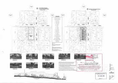
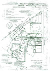
Document, Advertised Development Plan 424/2017/03P for 28 Luck Street, Eltham by R.P. Home Developments Pty Ltd, 29 January 2018
Former Eltham Specialist Centre Nillumbik Shire Council Advertised Application; 9 of 10 pages sourced from Eltham Community Action Group Facebook page, 21 March 2018 Buildings and works to construct (6) six dwellings and reduction of car parking requirements by not providing one visitor car space Digital image (9)eltham, eltham specialist centre, luck street, bible street, r.p. home developments pty ltd, streets -
 Glen Eira Historical Society
Letter - ELSTERNWICK POST OFFICE
This file contains seven items about the significance of this building and how this was established : 1/ Photocopies of a handwritten application (in duplicate) by Walter Kay of Elsternwick dated 13/10/1985 and Rodney H Bush’s dated 16/10/1985 to the Historic Buildings Council to register the former Elsternwick Post Office building, and an original typewritten letter dated 17/10/1985 from the Historic Buildings Council to Caulfield and Historic Society advising them of an application and inviting them to submit relevant information about the building with a copy of application attached. 2/ Six pieces of correspondence between various interested parties (Caulfield Council , Caulfield Historical Society, National Trust, of Australia and Ministry for Planning and Environment on behalf of Historic Buildings Council, Victoria) about the significance of the former Elsternwick Post Office building and the progress of efforts to include it on the Register of Historic buildings. Dated between November 1985 and May 1986. 3/ Two pieces of correspondence between the Caulfield Progress Association and the Caulfield Historical Society dated April and May 1986, regarding the efforts of the Historical Society to save the former Elsternwick Post Office building. 4/ Two pieces of ephemera by the Caulfield Progress Association, one original undated and one photocopy undated in 1986. Both appealing to the public for support to help the former Elsternwick Post Office building and to protest a proposal to demolish it, by Caulfield Council. 5/Original newspaper article dated 07/06/1989 from the Malvern-Caulfield Progress newspaper written by Robert Carmody. The article talks about the approval by the Historic Buildings Council of Caulfield Council’s restoration program of the former Elsternwick Post Office building worth approximately $850,000. The refurbishment would consist of a shop and office space which would then be rented out. Mayor Emil Braun outlines the progress to implement the plans. 6/ Caulfield Conservation Study by Andrew Ward dated September 1994 of former Elsternwick Post Office Building. The building plans for the Elizabethan Style building were approved in 1891. The original timber verandahs were replaced by the present brickworks in circa 1918 rear extensions in 1941-42. Similar Post Offices were built at Kew, Queenscliff and Portarlington. 7/ Computer printout dated 19/03/2010 of Statement of Significance held by the Victorian Heritage database of the former Elsternwick Post Office Building. It was built in 1891 in the ‘Queen Anne’ style. The substantial two story red brick building was set on a bluestone plinth with an ornate façade incorporating cement dressings. There is a brief summary of the settlement and development of the Elsternwick area with mention of how important the building is to the Elsternwick Community. Original date and author is unknown.elsternwick post office, glenhuntly road, elsternwick, riddell parade, office buildings, postal services, caulfield city council, kay walter, regent street, caulfield, bush rodney h, gisborne street, city of caulfield, braun emil councillor, mayors, aylen doug, aylen douglas r, historic buildings council, caulfield historical society, ministry for planning and environment, head stephen, historic buildings act 1981, anderson p, national trust of australia (victoria), public works department, architectural styles, calder g.k. councillor, wills cathie, lyall kerry, marsden john hudson, town clerk, hill douglas, caulfield progress association, caulfield south, glen eira road, hawthorn road, mac neil j.r., neville street, glenhuntly, marten veronika, ballantyne richard, royal historical society of victoria, dunstan don, alfada street south, hardy joan, baird rob, snowball betty, ward andrew, hoddle robert, foot henry, ebden charles hodson, elster, oldham mary kate, english ‘queen anne’ revival style, rifle club, coulson herbert h., fick p.g., railway, city manager, austin g.b. h., architects, builders, architectural features, australia post, register of historical buildings, grey karen, planning appeal board, heritage overlay no h029, victorian government gazette no. 60 dated 16/07/1986, historic building no640, certificate of title volume 5817, kennan james harley, nelson ivor, blake alison, neale anne, telegraph offices, wardell, ward andrew -
Federation University Historical Collection
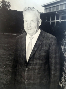
Annual Report, Ballarat School of Mines Annual Report, 1970
The Ballarat School of Mines was founded in 1970 and was the first institution of formal technical education in Australia. 1970 marked the centenary of the School and that of technical Education in Australia. A centenary commitee was established to plan activities and projecty sot celebrate the occasion. These included five centenary lectures fro secondary school students, a film of the School to be made and shown on National Television, a centenary medallion centenary posters, a dinner for local organisations with Council and staff as hosts, an historical notebook on the school, a plaque mounted to mark the site of the original school, opening of the Mt Helen Campus, Relocating the Old SMB battery ot mt Helen, student reunion, Art display of present and former students, Mt Helen Open Days and distribution of car stickers. A Centenary Appeal was established to finance a Great Hall and Sports Centre at the Mt Helen Campus. The Appeal President was Cr W.J.C. North. The materials testing laboratory secured and retained registration by the National Association of Testing Authorities for a range of tests on concrete and metals. The student accommodation at Mt Helen 23 Page report (with supplementary finances) in a soft cover showing a picture of the Former Ballarat Circuit Courthouse which was used as the first building of the Ballarat School of Mines. The report includes a page of stamps produced to commemorate the centenary of Technical Education in Australia through the Ballarat School of Mines. The report was presented by Council President Morgan Bevan John. The report includes information on the new campus for the Tertiary Division at Mt Helen, including information on the buildings being constructed by local builders. The site plan was developed by G.J. Harrison and L.H. Vernon and Associates. The following staff resigned: E.R. McGrath (deceased), E.W. Ryan, I.L. Hunter. The following new appointments were made: R.l. Martin, G.K. Tampi, T.F. Norwood, K.M. Llewellyn, M.J. Evans, J.F. Clark, K.G. Millar, B.R. Rollins, L.G. Shome, C.I. Dowling, M.H. Pitfield, G.M. Pearson, J.P. Murray, J.R. Thyer. Page 10 lists diplomas awarded and page 11 lists scholarships and prizes including the Ballarat has Company Scholarship, the Josephine Brelaz Scholarship, The Frank Pinkerton Scholarship, The Mica Smith/Serjeant/Ironworkers Scholarship, Martha Pinkerton Scholarship, Ballarat City Council Scholarship, Junior Art Scholarship, C.R.A. Scholarship, B.H.P. Scholarship, S.E.C. Scholarship, Alexander Rushal Scholarship, Russell and Shirley Evans Scholarship. The R.W. Richards Medal for 1969 was awarded to Peter Hensley. A new I.C.L. 1901A computer and associated equipment was purchased for the Computer Centre. Page 15 has information on the Victorian Institute of Colleges (VIC). Governor of Victoria, Sir Rohan Delacombe, with VIC's Dr Philip Law visited the Ballarat School of Mines and inspected both the old and new facilities. ballarat school of mines, m.b. john, centenary, anniversary -
 Federation University Historical Collection
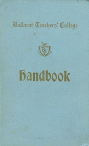
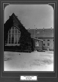
Booklet, Ballarat Teachers' College Handbook and Song Book
Students at the Ballarat Teachers' College would sing the songs in the songbook regularly. The Ballarat Teachers' College was established after the Victorian State Government and the State Education Department decided to establish two provincial teachers' colleges, at Ballarat and Bendigo. On 04 May 1926 W.H. Ellwood (Principal), Miss A. Bouchier, and Mr A.B. Jones, welcomed the first enrolment of 61 students to undertake the one year course. In 1927 the College moved to the former Ballarat East Town Hall in Barkly Street, which was remodelled for their use. It closed in December 1931 due to the Great Depression. In 1946 Ballarat Teachers' College reopened and relocated to the Dana Street State School. The building used by the Teachers' College was the original bluestone building facing Doveton Street South. It was originally planned to open as a women's college, for whom the residence at 130 Victoria Street was purchased, but the decision was made to admit resident men from Ballarat. Mr T.W. Turner was appointed as Principal in 1951 and directed the introduction of a two year course for the Trained Primary Teachers' Certificate. The former one year course was terminated at the end of 1951. In 1958 the College was relocated to a custom built facility at Gillies Street, in close proximity to the Ballarat Botanical Gardens. Numbers increased with the introduction of the Trained Infant Teachers' Certificate course under the guidance of Mary Egan. With the introduction of a three year Diploma Course in 1968 accommodation became cramped. The introduction of the Diploma of Teaching (Primary) led to the Trained Infant Teachers' Certificate being discontinued in 1969, and the end of the Trained Primary Teachers' Certificate in 1969. Secondary Art and Craft students began studies at Ballarat Teachers' College in 1969 under Mr Ted Doney. In 1971 Mr D. Watson was appointed Principal. The State College of Victoria was proclaimed by Order in Council on 24 July 1973, and Ballarat Teachers' College became a constituent college of the State College of Victoria, and was known as State College of Victoria, Ballarat. By 1975 the College moved to Mount Helen as part of the Ballarat College of Advanced Education. Pre service teachers currently undertake their studies on the Mount Helen Campus of Federation University. ("Ruffians Attempted to Carry of the School Tent: A History of State Education in Ballarat", 1974, p73-4.) 2 blue covered Ballarat Teachers' College Books, 1) Handbook of rules and songs. 2) Songbook.Inside front cover 'Monica Miller' autographs in inside book pages from the reunion on 1. 9. 1960 of BTC 1930ballarat teachers college, monica miller, extra muros, w h ellwood, entertainment, ellwood, ballarat teachers' college, music -
 Federation University Historical Collection
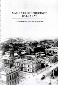
Book - Report, Camp Street Precinct Ballarat Conservation Management Plan, November 1999
This report was prepared for the City of Ballarat to assist in the process of planning for the future management and development of the Camp Street precinct.214 page report with spiral binding and a cover featuring a black and white image of the Ballarat Post Office, Ballarat Free Library and Ballarat State Offices. The report includes information on buildings in the Camp Street precinct including Art Gallery of Ballarat, old Colonists' Hall, former Police Court, former Police Station, Former Police Barracks, Government Camp (1852-1864), etcballarat fine art gallery, art gallery of ballarat, ballarat old colonists hall, ballarat former library, ballarat old court house, old ballarat police station, former ballarat post office, ballarat market reserve, ballarat benevolent reserve, bones building, old colonists hall, former ballarat call room, former ballarat police court, archaeology, aledandria tea room, former lister and angel warehouse, pratts warehouse, cms, conservation management plan, old colonists' hall, old colonists' association -
 Federation University Historical Collection
Photograph - Framed Photograph, Ballarat Teachers' College
These images were hung in the corridor of the University of Ballarat School of Education (Mount Helen). It most probably dates from around the time of the transfer of the College. The Ballarat Teachers' College was established after the Victorian State Government and the State Education Department decided to establish two provincial teachers' colleges, at Ballarat and Bendigo. On 04 May 1926 W.H. Ellwood (Principal), Miss A. Bouchier, and Mr A.B. Jones, welcomed the first enrolment of 61 students to undertake the one year course. In 1927 the College moved to the former Ballarat East Town Hall in Barkly Street, which was remodelled for their use. It closed in December 1931 due to the Great Depression. In 1946 Ballarat Teachers' College reopened and relocated to the Dana Street State School. The building used by the Teachers' College was the original bluestone building facing Doveton Street South. It was originally planned to open as a women's college, for whom the residence at 130 Victoria Street was purchased, but the decision was made to admit resident men from Ballarat. Mr T.W. Turner was appointed as Principal in 1951 and directed the introduction of a two year course for the Trained Primary Teachers' Certificate. The former one year course was terminated at the end of 1951. In 1958 the College was relocated to a custom built facility at Gillies Street, in close proximity to the Ballarat Botanical Gardens. Numbers increased with the introduction of the Trained Infant Teachers' Certificate course under the guidance of Mary Egan. With the introduction of a three year Diploma Course in 1968 accommodation became cramped. The introduction of the Diploma of Teaching (Primary) led to the Trained Infant Teachers' Certificate being discontinued in 1969, and the end of the Trained Primary Teachers' Certificate in 1969. Secondary Art and Craft students began studies at Ballarat Teachers' College in 1969 under Mr Ted Doney. In 1971 Mr D. Watson was appointed Principal. The State College of Victoria was proclaimed by Order in Council on 24 July 1973, and Ballarat Teachers' College became a constituent college of the State College of Victoria, and was known as State College of Victoria, Ballarat. By 1975 the College moved to Mount Helen as part of the Ballarat College of Advanced Education. Pre service teachers currently undertake their studies on the Mount Helen Campus of Federation University. ("Ruffians Attempted to Carry of the School Tent: A History of State Education in Ballarat", 1974, p73-4.) Framed black and white photograph of: .1) the former Ballarat East Town Hall .2) the old Dana Street Primary School during the era it was used as the Ballarat Teachers' College. The photographed is surrounded by a green matboard. .3) Ballarat Teachers' College, Gillies Street.Plaque under photo "Ballarat Teachers' College Doveton Street 1926, 1946-1957 (Part of Dana Street Primary School No. 33)ballaratteachers college, dana street primary school, teacher education, 00607 -
 Federation University Historical Collection
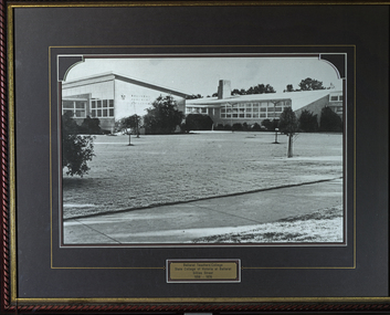
Photograph - Framed photograph, Ballarat Teachers' College Gillies Street
These images were hung in the corridor of the University of Ballarat School of Education (Mount Helen). It most probably dates from around the time of the transfer of the College. The Ballarat Teachers' College was established after the Victorian State Government and the State Education Department decided to establish two provincial teachers' colleges, at Ballarat and Bendigo. On 04 May 1926 W.H. Ellwood (Principal), Miss A. Bouchier, and Mr A.B. Jones, welcomed the first enrolment of 61 students to undertake the one year course. In 1927 the College moved to the former Ballarat East Town Hall in Barkly Street, which was remodelled for their use. It closed in December 1931 due to the Great Depression. In 1946 Ballarat Teachers' College reopened and relocated to the Dana Street State School. The building used by the Teachers' College was the original bluestone building facing Doveton Street South. It was originally planned to open as a women's college, for whom the residence at 130 Victoria Street was purchased, but the decision was made to admit resident men from Ballarat. Mr T.W. Turner was appointed as Principal in 1951 and directed the introduction of a two year course for the Trained Primary Teachers' Certificate. The former one year course was terminated at the end of 1951. In 1958 the College was relocated to a custom built facility at Gillies Street, in close proximity to the Ballarat Botanical Gardens. Numbers increased with the introduction of the Trained Infant Teachers' Certificate course under the guidance of Mary Egan. With the introduction of a three year Diploma Course in 1968 accommodation became cramped. The introduction of the Diploma of Teaching (Primary) led to the Trained Infant Teachers' Certificate being discontinued in 1969, and the end of the Trained Primary Teachers' Certificate in 1969. Secondary Art and Craft students began studies at Ballarat Teachers' College in 1969 under Mr Ted Doney. In 1971 Mr D. Watson was appointed Principal. The State College of Victoria was proclaimed by Order in Council on 24 July 1973, and Ballarat Teachers' College became a constituent college of the State College of Victoria, and was known as State College of Victoria, Ballarat. By 1975 the College moved to Mount Helen as part of the Ballarat College of Advanced Education. Pre service teachers currently undertake their studies on the Mount Helen Campus of Federation University. ("Ruffians Attempted to Carry of the School Tent: A History of State Education in Ballarat", 1974, p73-4.) This image was hung in the corridor of the University of Ballarat School of Education (Mount Helen). It most probably dates from around the time of the transfer of the Ballarat Teachers' College from Gillies Street to the Mount Helen Campus of the Ballarat College of Advanced Educaiton. The building used by the Teachers' College was the original bluestone building facing Doveton Street South.Framed black and white photography with green mount. The photo shows the Ballarat Teachers' College Gillies Street building. ON plaque 'Ballarat Teachers' College, State College of Victoria at Ballarat, Gillies Street, 1958-1976education, ballarat teachers college, gillies street, 00607 -
Federation University Historical Collection
Plan, Ballarat School of Mines and Industries Schematic Plan for the Former Brewery Site
... Former Ballarat Brewery Brewery Building buildings Copy ...Copy of a computer generated plan showing the layout of the Ballarat School of Mines campus, and the proposed building (now the Brewery Building).plan, former ballarat brewery, brewery building, buildings -
 Federation University Historical Collection
Magazine, Extra Muros, 1972, 1972
The Ballarat Teachers' College was established after the Victorian State Government and the State Education Department decided to establish two provincial teachers' colleges, at Ballarat and Bendigo. On 04 May 1926 W.H. Ellwood (Principal), Miss A. Bouchier, and Mr A.B. Jones, welcomed the first enrolment of 61 students to undertake the one year course. In 1927 the College moved to the former Ballarat East Town Hall in Barkly Street, which was remodelled for their use. It closed in December 1931 due to the Great Depression. In 1946 Ballarat Teachers' College reopened and relocated to the Dana Street State School. The building used by the Teachers' College was the original bluestone building facing Doveton Street South. It was originally planned to open as a women's college, for whom the residence at 130 Victoria Street was purchased, but the decision was made to admit resident men from Ballarat. Mr T.W. Turner was appointed as Principal in 1951 and directed the introduction of a two year course for the Trained Primary Teachers' Certificate. The former one year course was terminated at the end of 1951. In 1958 the College was relocated to a custom built facility at Gillies Street, in close proximity to the Ballarat Botanical Gardens. Numbers increased with the introduction of the Trained Infant Teachers' Certificate course under the guidance of Mary Egan. With the introduction of a three year Diploma Course in 1968 accommodation became cramped. The introduction of the Diploma of Teaching (Primary) led to the Trained Infant Teachers' Certificate being discontinued in 1969, and the end of the Trained Primary Teachers' Certificate in 1969. Secondary Art and Craft students began studies at Ballarat Teachers' College in 1969 under Mr Ted Doney. In 1971 Mr D. Watson was appointed Principal. The State College of Victoria was proclaimed by Order in Council on 24 July 1973, and Ballarat Teachers' College became a constituent college of the State College of Victoria, and was known as State College of Victoria, Ballarat. By 1975 the College moved to Mount Helen as part of the Ballarat College of Advanced Education. Pre service teachers currently undertake their studies on the Mount Helen Campus of Federation University. ("Ruffians Attempted to Carry of the School Tent: A History of State Education in Ballarat", 1974, p73-4.) Green soft covered magazine of the Ballarat Teachers' College. Includes black and white images of class groups and teachers. Art Lecturers of the Ballarat Teachers' College, 1972 Standing left to right: John Crump, Miss Brock, Ian Page, Gareth Sansom. Seated left to right: Ian Neilson, Greg Binns, Geoff Wallis mary vines, peter fryar, mary egan, alan sonsee, rod lindsay, pauline walker, sue kite, dave hughes, merran fisher, terry doran, frank howman, ian page, gareth sansom, greg binns, geoff wallis, barbara crump, ian nielson, bob croft, john crump, john mildren, genny binns, geoff hendy, ballarat teachers' college, rolf lindsay, graeme drendel, dennis spielvogel, ray woolard -
Federation University Historical Collection
Book - Report, Former Ballarat Brewery Conservation Analysis, 1994, 1994
The former Ballarat Brewery site was purchased by the Ballarat School of Mines in 1993 who commissioned the conservation management plan. It has closed as a brewery in 1989 and the plant and fittings auctioned. The buildings were demolished and a new educational facility known as the brewery Complex was built, using some elements of the former brewery in its design. 124 page report copied onto A4 white paper, with additional appendices and definitions. Contents include brewing in Australia, site history, Tulloch & McLaren Royal Standarg Brewery, Henry Caselli, Ballarat Brewing Company, Physical Survey and comparitive analysis.ballarat school of mines, henry richards caselli, henry caselli, chimney, ballarat brewery, carlton and united breweries, tulloch and mclaren, henry r caselli, ballarat brewing company, cub, brewing tower, brew tower, boiler and engine room, cooling tower -
 Federation University Historical Collection
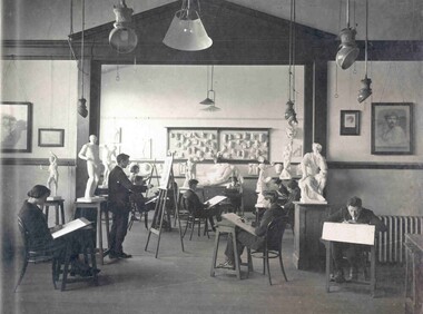
Photograph - Art class photograph, Drawing from the Antique, 1920, c1920
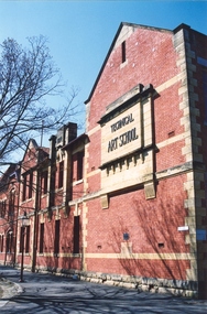
The large plaster Illisos depicted in the back of this image is still held by Federation University Australia. The Ballarat Technical Art School (No. 10) was part of the Ballarat School of Mines and was established in 1907. After conducting classes in various locations around Ballarat a custom built art school was erected on the site of the former Ballarat Circuit Court House, previously used as the initial building of the Ballarat School of Mines. Examples of drawings undertaken by students, as well as some plaster castes are held in the University of Ballarat Historical Collection. The Ballarat Technical art School is the oldest continuous Tertiary Art School in Australia. Sir Alexander Peacock opened the new Ballarat Technical Art School building in July 1915. It cost 10,000 pounds and was constructed by the Public Works Department from plans drawn by the then Art School Principal, Herbert H. Smith. The building contractors were Messrs Gower and Eddards. According to the SMB Annual Report of 1914 'the internal upholstering and fittings have all been carried out in Australian timbers, with Queensland maple largely used throughout.' The building could be described as federation-art deco in style. It features sandstone insertion with sandstone string coursing. The base of the building is rusticated sandstone. The building is functional in design with large metal windows in the south wall to ensure good light into the studios. The northern wall has standard double hung windows. The interior of the building features a carved wooden staircase and cast iron ceiling vents. The rear drawing studios could be made into one large studio by opening panelled timber doors. This opening features classical plaster pilasters with a pediment above. (http://guerin.ballarat.edu.au/curator/buildings/technical_art_school.shtml) Black and white mounted photograph showing eleven students of the Ballarat School of Mines Technical Art School drawing from plaster models of human bodies in various poses and of various scales. The students are in a room of the Ballarat Technical Art School which was custom built for teaching art. The image was reproduced in the 1920 Ballarat School of Mines Students' Magazine. drawing, ballarat school of mines, ballarat technical art school, art studio, plaster caste, gribble building, illisos, hercules, drawing from the antique, visual arts -
 Federation University Historical Collection
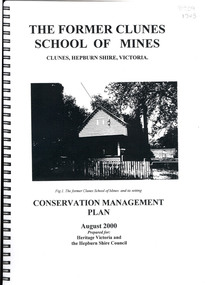
Book, The Former School of Mines Clunes Conservation Management Plan, 2000, 08/2000
The Clunes School of Mines was a campus of the Ballarat School of Mines. The conservation plan was prepared for Hepburn Shire Council and Heritage Victoria to guide the future management of the former Clunes School of Mines in Service Street, Clunes, The building was opened in February 1892 as the Clunes branch of the Ballarat School of Mines, and ceased operating in June 1893.Spiral bound black and white copy of the Conservation Plan for the Clunes School of Mines. Contents include the history, chronology development, context of the building and site, current and past function of the building, original fabric, impact of later alterations, condition of the building, statement of significance, conservation action plan, caring for the site, collecting and keeping information, structural engineers Report, Department of Lands Survey 1955, Memorandum of Agreement 1956.ballarat school of mines, clunes school of mines, australian native association, ana, australian native association clunes branch, eygelaar inner spring mattress factory, clunes infant welfare centre, clunes angling club -
 Federation University Historical Collection
Book, Camp Street Precinct Ballarat Conservation Management Plan (Draft), 1999, 10/1999
The conservation management plan was commissioned by the City of Ballarat to assist in the process of planning for the future management and development of the Camp Street precinct, having particular regard for the Camp Street Arts and Education Precinct.White, soft covered, spiral bound book relating to Ballarat's Camp Street Precinct. Contents include: Methodology, buildings and site layout. ballarat, camp street, clare gervasoni, ballarat fine art gallery, art gallery of ballarat, old colonists' hall, former ballarat mining exchange, former state offices, former police court, former police station, former police barracks, old police station, arts academy, archaeology, conservation management plan -
Federation University Historical Collection
Document, Graeme Tyrrell, Overview for the Development of Gardens Lydiard Street Campus, 1988, 01/12/1988
The report was prepared by Graeme Tyrrell, headgroundsman/Gardener at the Ballarat School of Mines (SMB) for Bob Feary, Manager of Facilities at SMB. The report was designed to present a broad cover of current plans for specific sites at the Lydiard Street campus.Seven page report on the development of the Ballarat School of Mines Gardens, including the Motor Mechanics Portable, Hickman Street (now demolished); Recreation Building (now demolished), E.P.U.Y Building, Hickman Street, vacant block behind creche (now site of UBTec building); Creche, Grant Street (now demolished); Former Courthouse building, Grant Street terrace, Brick Court yard, conifer beds lining Lydiard Street, Herb Garden above M.B. John Building, Terrraced area above Ballarat School of Mines Botanical Garden (referred to as Von Mueller garden). The report includes a campus plan. The report is copied onto white paper and is stapled at the top left corner. ballarat school of mines botanical gardens, ballarat school of mines, bob feary, graeme tyrrell, gardens, ballarat school of mines campus, smb campus -
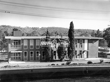
 Federation University Historical Collection
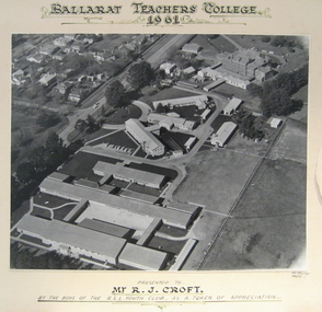
Photograph - Photograph - Black and White, Ballarat Teachers' College, Gillies Street, 1961, 1961
The Ballarat Teachers' College was established after the Victorian State Government and the State Education Department decided to establish two provincial teachers' colleges, at Ballarat and Bendigo. On 04 May 1926 W.H. Ellwood (Principal), Miss A. Bouchier, and Mr A.B. Jones, welcomed the first enrolment of 61 students to undertake the one year course. In 1927 the College moved to the former Ballarat East Town Hall in Barkly Street, which was remodelled for their use. It closed in December 1931 due to the Great Depression. In 1946 Ballarat Teachers' College reopened and relocated to the Dana Street State School. The building used by the Teachers' College was the original bluestone building facing Doveton Street South. It was originally planned to open as a women's college, for whom the residence at 130 Victoria Street was purchased, but the decision was made to admit resident men from Ballarat. Mr T.W. Turner was appointed as Principal in 1951 and directed the introduction of a two year course for the Trained Primary Teachers' Certificate. The former one year course was terminated at the end of 1951. In 1958 the College was relocated to a custom built facility at Gillies Street, in close proximity to the Ballarat Botanical Gardens. Numbers increased with the introduction of the Trained Infant Teachers' Certificate course under the guidance of Mary Egan. With the introduction of a three year Diploma Course in 1968 accommodation became cramped. The introduction of the Diploma of Teaching (Primary) led to the Trained Infant Teachers' Certificate being discontinued in 1969, and the end of the Trained Primary Teachers' Certificate in 1969. Secondary Art and Craft students began studies at Ballarat Teachers' College in 1969 under Mr Ted Doney. In 1971 Mr D. Watson was appointed Principal. The State College of Victoria was proclaimed by Order in Council on 24 July 1973, and Ballarat Teachers' College became a constituent college of the State College of Victoria, and was known as State College of Victoria, Ballarat. By 1975 the College moved to Mount Helen as part of the Ballarat College of Advanced Education. Pre service teachers currently undertake their studies on the Mount Helen Campus of Federation University. ("Ruffians Attempted to Carry of the School Tent: A History of State Education in Ballarat", 1974, p73-4.) Aerial photograph of the Gillies Street Campus of Ballarat Teachers' College glued onto card."Ballarat Teachers' College 1961 presented to R.J. Croft by the boys of the RSL Youth Club, as a token of appreciationballarat teachers' college, r.j. croft, rsl youth club -
 Federation University Historical Collection
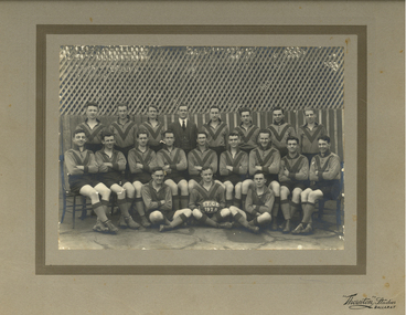
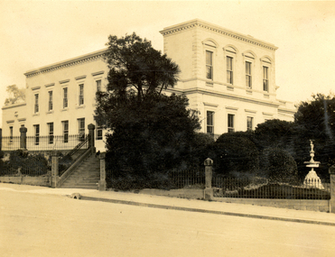
Photograph - Photograph - black and white, Ballarat Teachers' College Football Team, 1928, 1928
This photo was taken at the Ballarat East Town Hall. The Ballarat Teachers' College was established after the Victorian State Government and the State Education Department decided to establish two provincial teachers' colleges, at Ballarat and Bendigo. On 04 May 1926 W.H. Ellwood (Principal), Miss A. Bouchier, and Mr A.B. Jones, welcomed the first enrolment of 61 students to undertake the one year course. In 1927 the College moved to the former Ballarat East Town Hall in Barkly Street, which was remodelled for their use. It closed in December 1931 due to the Great Depression. In 1946 Ballarat Teachers' College reopened and relocated to the Dana Street State School. The building used by the Teachers' College was the original bluestone building facing Doveton Street South. It was originally planned to open as a women's college, for whom the residence at 130 Victoria Street was purchased, but the decision was made to admit resident men from Ballarat. Mr T.W. Turner was appointed as Principal in 1951 and directed the introduction of a two year course for the Trained Primary Teachers' Certificate. The former one year course was terminated at the end of 1951. In 1958 the College was relocated to a custom built facility at Gillies Street, in close proximity to the Ballarat Botanical Gardens. Numbers increased with the introduction of the Trained Infant Teachers' Certificate course under the guidance of Mary Egan. With the introduction of a three year Diploma Course in 1968 accommodation became cramped. The introduction of the Diploma of Teaching (Primary) led to the Trained Infant Teachers' Certificate being discontinued in 1969, and the end of the Trained Primary Teachers' Certificate in 1969. Secondary Art and Craft students began studies at Ballarat Teachers' College in 1969 under Mr Ted Doney. In 1971 Mr D. Watson was appointed Principal. The State College of Victoria was proclaimed by Order in Council on 24 July 1973, and Ballarat Teachers' College became a constituent college of the State College of Victoria, and was known as State College of Victoria, Ballarat. By 1975 the College moved to Mount Helen as part of the Ballarat College of Advanced Education. Pre service teachers currently undertake their studies on the Mount Helen Campus of Federation University. ("Ruffians Attempted to Carry of the School Tent: A History of State Education in Ballarat", 1974, p73-4.)Mounted photograph of the football team of the Teacher Training College Ballarat. Ron Robson is 3rd from the right in the centre row. He later lived at Merbein, Victoriaballarat teachers' college, teacher training college ballarat, football, ballarat teachers' college football team, thornton studios, ballarat east town hall -
 Federation University Historical Collection
Programme - Card, Ballarat Teachers' Reunion Souvenir, 1933, 1933
This card was used by John McNaughton, student of the Ballarat Teachers' College in 1929. The Ballarat Teachers' College was established after the Victorian State Government and the State Education Department decided to establish two provincial teachers' colleges, at Ballarat and Bendigo. On 04 May 1926 W.H. Ellwood (Principal), Miss A. Bouchier, and Mr A.B. Jones, welcomed the first enrolment of 61 students to undertake the one year course. In 1927 the College moved to the former Ballarat East Town Hall in Barkly Street, which was remodelled for their use. It closed in December 1931 due to the Great Depression. In 1946 Ballarat Teachers' College reopened and relocated to the Dana Street State School. The building used by the Teachers' College was the original bluestone building facing Doveton Street South. It was originally planned to open as a women's college, for whom the residence at 130 Victoria Street was purchased, but the decision was made to admit resident men from Ballarat. Mr T.W. Turner was appointed as Principal in 1951 and directed the introduction of a two year course for the Trained Primary Teachers' Certificate. The former one year course was terminated at the end of 1951. In 1958 the College was relocated to a custom built facility at Gillies Street, in close proximity to the Ballarat Botanical Gardens. Numbers increased with the introduction of the Trained Infant Teachers' Certificate course under the guidance of Mary Egan. With the introduction of a three year Diploma Course in 1968 accommodation became cramped. The introduction of the Diploma of Teaching (Primary) led to the Trained Infant Teachers' Certificate being discontinued in 1969, and the end of the Trained Primary Teachers' Certificate in 1969. Secondary Art and Craft students began studies at Ballarat Teachers' College in 1969 under Mr Ted Doney. In 1971 Mr D. Watson was appointed Principal. The State College of Victoria was proclaimed by Order in Council on 24 July 1973, and Ballarat Teachers' College became a constituent college of the State College of Victoria, and was known as State College of Victoria, Ballarat. By 1975 the College moved to Mount Helen as part of the Ballarat College of Advanced Education. Pre service teachers currently undertake their studies on the Mount Helen Campus of Federation University. ("Ruffians Attempted to Carry of the School Tent: A History of State Education in Ballarat", 1974, p73-4.)Printed card with a black and white photo of the Ballarat Teachers' College (former Ballarat East Town Hall).ballarat teachers' college, mcnaughton, john mcnaughton, former ballarat east town hall, ballarat east gardens -
 Federation University Historical Collection
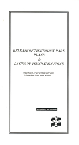
Programme, Release of Technology Park Plans and Laying of Foundation Stone, 1995, 02/1995
The Ballarat Technology Park site consists of 28.8 hectares of freehold land zoned for technology Purposes. The development plan for the Park was prepared by the City of Ballarat. The construction of the ISSC Southern Regional Data Centre was the first stage of the project. ISSC Southern Regional Data centre is a $12.5 million building development at the corner of Geelong Road and gear Avenue. The building was constructed by H. Troon Pty Ltd. White card program for the Release of Technology Park Plans and Laying of Foundation Stone. ballarat technology park, issc southern region data centre, troon, david james, geoffrey blainey, bruce clark, john bligh, roger hallam, campus plan -
 Federation University Historical Collection
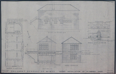
Plan (copy), Ballarat School of Mines Plumbing Building, 1954
.1) Ballarat School of Mines Sound Installation of Plumbing Shop, by architect John Firth, 1954 .2) Plan and sections of the proposed Scheme - conversion of Ballarat School of Mines Clay Mill Building to Fluid Mechanics Laboratory, by architect John E. Dixon, 1962 .3) Plan for Ballarat School of Mines New Sanitary Accomodation, 1967 .4) Plan for Ballarat School of Mines Extension to Existing Workshop by architect Percy E. Everett. The plan includes the former Ballarat Supreme Courtjohn firth, percy everett, john e. dixon, ballarat school of mines, clay, ceramics, plumbing, buildings, architectural plan -
 Federation University Historical Collection
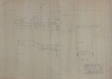
Plan, Ballarat School of Mines Preliminary Drawings for a Covered Way between Plumbing and Tippett Hall, 1962, 09/01/1962
Plan includes Ballarat School of Mines Administration Building and Tippett Hall (former Wesley Church)ballarat school of mines, architectural plan, plumbing, tippett hall, former wesley church, former ballarat school of mines museum -
Federation University Historical Collection
Plan, Ballarat Gaol Sewerage Plan (photocopy), 05/1927
The site of the former Ballarat gaol is now part of Federation University's SMB campus.A3 plan with 6 additional works added to original plan. The last addition was 22 August 1947. WGS 84 37 degrees 33 feet 58 inches S 143 degrees 51 feet 24 inches Eballarat gaol, arthur lasser, gaol, ballarat school of mines, buildings -
 Federation University Historical Collection
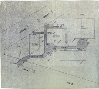
Plan, Plan for a Service Plan at the Ballarat School of Mines
This plan appears to show buildings that were not built. Plkan showing the section of the Federation University SMB Campus between Grant Street and Lydiard Street, near Armstrong Street South.smb campus, ballarat school of mines, grant street, lydiard street, former ballarat supreme court -
 Federation University Historical Collection
Plan, Plan Former Ballarat Gaol and Ballarat School of Mines Buildings, 1926/1927
... building. ballarat school of mines ballarat gaol plan student ...After the closure or the Ballarat Gaol the space was taken over by the Ballarat SChool of Mines and the gaol building was demolished. The E.J. Tippett Library is now on the site of the former Gaol building.Copy of 1928 plans for the Ballarat Gaol, with two Ballarat School of Mines buildings marked on it - The Student Amenities building and the Learning Resource Centre (E.J. Tippett Library). It shows a 'future Teaching Building' which was never built.ballarat school of mines, ballarat gaol, plan, student amenities building, learning resource centre, e.j. tippett library, governor's residence, warden's residence -
 Federation University Historical Collection
Book - ledger, Ballarat School of Mines Reports, 1900-1915, 1900-1915
27 June 1902 - Davey Paxmen Steam Engine 01 September 1905 - James Oddie donation a pair of lanterns and a lantern Microscope 03 August 1906 - Costs of starting an Agricultural High School in the district - Dr Stewart Bequest 29 April 1910- Planning for new Art School Building 28 April 1911 - Ballarat Observatory 26 May 1911 - Ballarat Observatory. Mr Brittain living in the caretaker's cottage, and proposes moving his telescope to the observatory 30 June 1911 - H.H. Smith in conjunction with Mr Clegg asked to prepare sketch plans for a new art school 28 July 1913 - Establishment of the Ballarat Junior Technical School 04 April 1913 - Removal of organ and pipes from the former Wesleyan Church 26 June 1914 - Laying of the Foundation Stone for the Ballarat Technical Art School. A photograph was taken featuring Mr Tate, Mr Carew-Smyth and Col. Watson.Black covered foolscap book with brown leather spine and corners. The handwritten reports were written for the Ballarat School of Mines Councilballarat school of mines, monthly reports, ballarat school of mines principal, ballarat school of mines principal's report, ballarat school of mines battery, ballarat school of mines council, r.t. vale, davey paxmen, andrew anderson, james bickett, james oddie, david kerr, j. baird, learmonth, dr stewart bequest, ballarat technical art school, h.h. smith, w.h. middleton, clegg -
 Federation University Historical Collection
Photograph - Photograph - Black and White, M.B. John Building, Federation University SMB Campus, c1992, c1989
Morgan Bevan John was a president of the Ballarat School of Mines for many years. In 2014 the building was used for Ceramics and 3D Art, other former uses now being carried out in the Skills Centre. The M.B. John Trade–Art building (Albert Street front) of SMB was officially opened by the Hon. John Cain, Premier of Victoria, in the presence of Morgan B. John. Programs include 3 Dimensional Art, Painting & Decorating, and Engineering Trades. (SMB Institutional Plan 1989)Two black and white photographs of the MB John building at Federation University SMB campus. The building fronts Albert Street, Ballarat. .2) shows the edge of the Ballarat School of Mines Botanical Gardens.ballarat school of mines, john, ballarat school of mines botanical gardens, flecknoe, m.b. john, vocational skills, morgan b. john, albert street, buildings -
 Federation University Historical Collection
Photograph, Clare Gervasoni, Ballarat School of Mines Technical Art School, c2008, c2008
The former Ballarat Circuit Court Building, later the first building of the Ballarat School of Mines, was demolished to make way for a new custom built Art School building. Sir Alexander Peacock opened the Ballarat Technical Art School in July 1915. It cost 10,000 pounds and was constructed by the Public Works Department from plans drawn by the then Art School Principal, Herbert H. Smith. The building contractors were Messrs Gower and Eddards. According to the SMB Annual Report of 1914 'the internal upholstering and fittings have all been carried out in Australian timbers, with Queensland maple largely used throughout.' Before this building was constructed art and craft classes were held in various buildings around Ballarat. The building could be described as federation-art deco in style. It features sandstone insertion with sandstone string coursing. The base of the building is rusticated sandstone. The relief stone panel on the front with the words "Technical Art School" features stone pilaster brackets and corbels. In the centre front can be seen rectangular sandstone pediment with decorative stonework incorporating the date of construction. The windows in the lower floor feature five supporting keystones whereas the upper windows have sandstone lintels. The building also features decorative cast iron downpipes. The entrance on the northern side has attractive leadlight glazing in an art deco style. Above the door a miner's lamp and pick are featured in the design. The building is functional in design with large metal windows in the south wall to ensure good light into the studios. The northern wall has standard double hung windows. The interior of the building features a carved wooden staircase and cast iron ceiling vents. The rear drawing studios can be made into one large studio by opening panelled timber doors. This opening features classical plaster pilasters with a pediment above.Colour photographs of a double storey, red brick building built - the Ballarat Technical Art School, a division of the Ballarat School of Minesballarat school of mines, ballarat technical art school, architecture, art, gribble building -
 Federation University Historical Collection
Photograph - Photographs - Black and White, Ballarat Teachers' College
These images were hung in the corridor of the University of Ballarat School of Education (Mount Helen). It most probably dates from around the time of the transfer of the College. The Ballarat Teachers' College was established after the Victorian State Government and the State Education Department decided to establish two provincial teachers' colleges, at Ballarat and Bendigo. On 04 May 1926 W.H. Ellwood (Principal), Miss A. Bouchier, and Mr A.B. Jones, welcomed the first enrolment of 61 students to undertake the one year course. In 1927 the College moved to the former Ballarat East Town Hall in Barkly Street, which was remodelled for their use. It closed in December 1931 due to the Great Depression. In 1946 Ballarat Teachers' College reopened and relocated to the Dana Street State School. The building used by the Teachers' College was the original bluestone building facing Doveton Street South. It was originally planned to open as a women's college, for whom the residence at 130 Victoria Street was purchased, but the decision was made to admit resident men from Ballarat. Mr T.W. Turner was appointed as Principal in 1951 and directed the introduction of a two year course for the Trained Primary Teachers' Certificate. The former one year course was terminated at the end of 1951. In 1958 the College was relocated to a custom built facility at Gillies Street, in close proximity to the Ballarat Botanical Gardens. Numbers increased with the introduction of the Trained Infant Teachers' Certificate course under the guidance of Mary Egan. With the introduction of a three year Diploma Course in 1968 accommodation became cramped. The introduction of the Diploma of Teaching (Primary) led to the Trained Infant Teachers' Certificate being discontinued in 1969, and the end of the Trained Primary Teachers' Certificate in 1969. Secondary Art and Craft students began studies at Ballarat Teachers' College in 1969 under Mr Ted Doney. In 1971 Mr D. Watson was appointed Principal. The State College of Victoria was proclaimed by Order in Council on 24 July 1973, and Ballarat Teachers' College became a constituent college of the State College of Victoria, and was known as State College of Victoria, Ballarat. By 1975 the College moved to Mount Helen as part of the Ballarat College of Advanced Education. Pre service teachers currently undertake their studies on the Mount Helen Campus of Federation University. ("Ruffians Attempted to Carry of the School Tent: A History of State Education in Ballarat", 1974, p73-4.)Three photographs of the Ballarat Teachers' College, all at different locaitons. .1) Dana Street Primary School (State School) .2) Barkly Street - former Ballarat East Town Hall .3) Gillies StreetBrass plaque on each framed photograph .1) Ballarat Teachers' College Doveton Street 1926, 1946-1957 (Part of Dana Street Primary School No. 33) .2) Ballarat Teachers' College Barkly Street 1927-1931 (Formerly Ballarat East Town Hall) .3) Ballarat Teachers' College State College of Victoria at Ballarat Gillies Street 1958-1976ballarat teachers' college, dana street primary school, ballarat east library, gillies street, state college of victoria, state college of victoria at ballarat