Showing 64 items matching "port fairy show"
-
 Flagstaff Hill Maritime Museum and Village
Document, 12-01-1882
This hand written letter, in black ink script on blue lined paper, is impressed with the official stamp of the Victoria Steam Navigation Board. The left margin has the reference “S82/12" It is transcribed: "Victoria Steam Navigation Board, Melbourne, January 12th 1882 To Frederick Chapman, Master, S.S. "Julia Percy" You are herewith furnished with a copy of the report of the Official Court which assembled to enquire into the circumstances attending the collision between the steamers "Julia Percy" and "Nelson" off Apollo Bay near Cape Otway on the morning of the 25th December 1881, and you are hereby expected to attend at the Board Room, Custom House, Melbourne, at 2pm, on 13th January instant to show cause why you should not be censured accordingly. [Signature] Secretary" This document refers to the matter of a collision between two steamships, the Julia Percy and the Nelson, on 25th December 1881. The Julia Percy was at that time owned by her first owners, the Warrnambool Steam Packet Company, and she sailed under the command of Captain Chapman. She had left Melbourne the evening of 24th December, with about 150 passengers, sailing in fine weather through Port Phillip Heads around 9pm. She was headed for Warrnambool, Belfast (now named Port Fairy) and Portland. The Julia Percy was off Apollo Bay when Captain Chapman was woken by the ship’s whistle after midnight, the steamer Nelson being on a collision course with the Julia Percy.[See Link.] The Nelson struck Julia Percy midship. Boats were lowered from the ship (apart from a damaged lifeboat) and about 30-40 of the passengers boarded the Nelson. The engine room and the forehold were checked and found clear of water. The company manager, Mr Evans, had been on the Nelson, so he boarded and inspected the Julia Percy and the decision was made to continue on to Warrnambool with the passengers as there appeared to be no immediate danger. However, Captain Thomas Smith said the Nelson was taking on water, so Julia Percy followed her for about an hour towards Melbourne on standby in case of need. Then Julia Percy turned around towards Warrnambool again. Shortly afterwards the Nelson turned to follow her, the ships stopped and passengers were returned to Julia Percy, and three from Julia Percy boarded the Nelson. Both ships proceeded on their way. Julia Percy passed Cape Otway light afterwards, signalling that there had been a collision. It was discovered later that one of the passengers was missing, then thought to have boarded the Nelson but later thought to have fallen into the sea and drowned while trying to jump from Julia Percy to Nelson. There had been 3 tickets purchased under the same name of that passenger “Cutler”; a father, son and friend named Wordsworth, which had caused quite some confusion. No further mishap occurred to either ship and both the Julia Percy and the Nelson reached their destinations safely. An enquiry was instigated by the Victoria Steam Navigation Board regarding the cause of the accident between the two steamships, in connection with the death of Cutler who was supposed to have lost his life by the collision. The enquiry resulted in the following decision: "The Victorian Steam Navigation Board having taken into consideration the points urged by Captain Thos [Thomas] Smith and also by his legal advisers, is of opinion that the charge prepared against him has been sustained, but taking into consideration Captain Smith’s previous good conduct and character, the board suspends his master’s certificate No 227 issued by this board for a period of six calendar months from this date – Robert Fullarton, Chairman. “The Victorian Steam Navigation Board having beard the statement of Captain Frederick Chapman urged in his defense to the charge of dereliction of duty as master of the Julia Percy, in having no standing order on board that vessel to be called in the event of any approaching steamer’s lights being seen, find such charge sustained, and censure him accordingly – Robert Fullarton, Chairman.” ABOUT “JULIA PERCY” The S.S. Julia Percy (later named Leeuwin ) was an iron passenger-cargo steam ship built in 1876. At one point in time the Julia Percy would sail from Warrnambool to Melbourne every Friday and return from Melbourne to Warrnambool every Tuesday. The cost of a return ticket for a Saloon Fare was £1.0.0. She would sail “if practical and weather permitting”. Shipping was the cheapest and most practical means of carrying produce and goods during the period 1840-1890. Regular domestic steamer services commenced in the Warrnambool district in the late 1850’s and by 1870 the passenger trade was booming. Produce was loaded from the jetty into ‘lighters’ (small boats), which took it to the ships at anchorage in the bay. Passengers were taken to the ship’s side then climbed aboard up ladders or gangways. The coming of the railway in October 1889 meant the gradual decline and end of the steam shipping era. The Julia Percy was built in Glasgow by Thomas Wingate & Company, Whiteinch, in 1876 for the Warrnambool Steam Packet Company, which commissioned her for trade in Victoria’s western district. She was first registered in Warrnambool, Victoria in 1876. The Julia Percy changed hands several times. Her next owner was the Western Steam Navigation Co (1887), managed by Mr. T.H. Osborne (the company’s office was on the corner of Timor and Liebig Streets, Its north-western wall is now part of the current Warrnambool Regional Art Gallery. ) The Melbourne Steamship Co became the next owners (1890), followed by William Howard Smith and Sons (1901) for use in Queensland coastal trades, then she was bought by George Turnbull in 1903 and used for local mail contract in Western Australia. The Julia Percy was sold to the Melbourne Steamship Company Ltd. (1906) and re-named the “Leeuwin” but continued in her Western Australian coastal run. She was converted into a coal hulk in Melbourne in 1910 as a result of damaged caused when she was driven against the jetty at Dongara during a gale. The ship was eventually dismantled and scuttled in Bass Strait on 28 December 1934. The document is significant for its association with the wreck of the Leeuwin (Julia Percy), which is on the Victorian Heritage Register, VHR S413. . It is historically significant for being a rare artefact that has potential to interpret aspects of Western Victoria’s 19th century steamship trade and Victorian cultural history. The Leeuwin (Julia Percy) is listed on the Victorian Heritage Register as being historically significant ‘as one of only four wrecks of steamships in Victorian waters associated with the western district of Victoria’s coastal steamship trade. Reports of Victoria Steam Navigation Board about the collision on 25th December 1881 between the steamers " Julia Percy" and "Nelson". Letter from Victoria Steam Navigation Board, Melbourne to Frederick Chapman, Master, S.S. "Julia Percy", dated January 12th 1882. reference on letter in left margin "S82/12"flagstaff hill, flagstaff hill –maritime museum, maritime museum, shipwreck coast, flagstaff hill maritime village, victoria steam navigation board, captain frederick chapman, captain thomas smith, thomas wingate & company, steamer julia percy, steamer leeuwin, steamer nelson, steam ship, warrnambool steam packet company, t. h. ostorne, western steam navigation co., charles cutler -
 Flagstaff Hill Maritime Museum and Village
Document - Framed Poster, Borough of Warrnambool, Victoria, Australia, after 30/06/1875
This document, also referred to as a word picture or Tablet, is framed in glass and timber with gilt trim, is handwritten with colour highlights. The penned letters rest on ruled guide lines, decorated where the lines intersect. The writing gives a description of the state of Borough of Warrnambool around 1875; its location, the area it covers, its population, Harbour and facilities, public buildings and institutions, imports and exports, financial worth, number of houses, connection with other areas of the Colony. A possible reason and origin for the document is found in an article ‘Link with US Exhibition’ from the Warrnambool Standard of December 19, 1981, written by local historian Bruce Morris. The writer mentions that the Warrnambool Borough Council met on 15th June 1875 and recorded a letter from G.C. Levey , secretary to the Melbourne group of commissioners representing the Colony, and Victoria in particular, for the Philadelphia Centennial Exhibition of 1876. The letter asks Council to provide “statistics as to the population, social condition and commercial and industrial state of the district in and around Warrnambool.” A sub committee was formed for the project. The Mayor, Cr. Thomas King, wrote and signed a Report, presented to the council on July 14, 1875, in which “The Committee … begs to recommend that a Tablet be prepared setting for the particulars respecting the following matters relating to the Borough”. The matters included area, population, annual income, churches, schools, other public buildings, societies and companies, general description of houses erected, and returns of exports and imports for 1874. The minutes note that the Report was adopted. The article above also notes the opinion of Warrnambool printers who have examined the document; it is almost certainly to be an old lithograph, which means there could be several copies. It is possible that there may be a copy in Melbourne and another in Philadelphia. It is interesting to note that (1) the quoted location co-ordinates are for an “Unnamed Road, Packsaddle NSW 2880, Australia”, and that the DMS co-ordinates for Warrnambool’s Council Offices differ, being 38.23.9.12 South, 142.28.52.887. (2) the date for “Exports and Imports for the Year Ending 30th June 1875” is different to the period mentioned by Cr. King in the sub committee’s Report of recommendation “returns of exports and imports for 1874”. The information required to have the figures for the end of June 1875 would need to have been compiled very quickly for the Tablet to be ready for the opening of the Philadelphia Exhibition on 10 May 1876. The document/certificate shows the following – - - - - - - - - - - - - - - -- - - - - - - - - - - - - - -- - - - - - - - - - - - - - -- - - - - - - - - - - - - - - “Victoria Australia, Borough of Warrnambool. Latitude, 30.24.50 South, Longitude 142.32 East The Principal Port in the Western District of the Colony and the Centre of its Choicest Agricultural Lands. Established a Municipality in 1855, and Created a Borough 1863. Population in 1875 4,500. Warrnambool is the nearest Port to Melbourne on the Western Seaboard, being about 160 miles distant. Coaches run to and from the Metropolis daily, in connexion [connection] with the Railway of Geelong and Steamers belonging to Local Companies sail between Melbourne, Warrnambool, Belfast [renamed Port Fairy], and Portland several times weekly. The Harbour is known as Lady Bay, and is partially protected by a reef of rocks stretching from the mouth of the Hopkins River. The formation of a Breakwater has been decided upon by the Government, to extend 600 yards, at an estimated cost of £100,000. There are two substantial Jetties, one of 800 and the other of 600 feet in length. The former is connected with the Town by means of a Tramroad, along which Goods, inwards & outwards, are conveyed, & the latter has been constructed solely for the purpose of facilitating the transit of material for the formation of the Breakwater. In addition to the trade of the Borough and District, the principal Townships up country receive their supplies from Melbourne and ship their exports through Warrnambool. Potatoes form the staple produce of the district, and the richness of the soil can be estimated by the fact that the Government Statistics for 1875 give as the average yield a return of Seven Tons to the acre. Several thousand acres between Warrnambool and Tower Hill are now being laid down in Potatoes by Tenants who have leased the lands at rates up to £5 per acre for the season 1875-6. Wool, Tallow, hides &c are also largely exported, while the shipments of all descriptions of Farm Produce are annually increasing. Area of Borough, 3362 Acres. Net Annual Value £27,000. Annual Revenue £5,500. Number of Houses in Borough 800. Public Buildings and Institutions Churches. Church of England, Roman Catholic, Presbyterian, Wesleyan, Congregational and Baptist. Schools. Three State Schools, average attendance nearly 1000. New Building in course of erection. Several private establishments. Banks. Bank of Australasia, Bank of Victoria, National Bank, Colonial Bank and Savings Bank. Public Buildings. Court house, Custom house, Post & Telegraph Offices, Survey & Land Offices, Shire £, Town Hall, Mechanics Institute, Volunteer Orderly Room, Odd Fellows Hall, Hospital & Benevolent Asylum, Temperance Hall &c. Companies & Societies. Steam Navigation Co, Woolen Mill Co, Gas Co, Racing Club, Amateur Turf Club, Agricultural Society, Farmers’ Club, Cricket Club, Anglers’ Society, Building Society, Freemasons Odd Fellows, Foresters, Druids, Hibernians. Protestant Alliance, Rechabites, Sons of Temperance, &c, Fire Brigade &c. --- Exports and Imports for the Year Ending 30th June 1875 –-- --Exports Total Tonnage 27,800 (Calculated at the Current Warrnambool Market Prices) Potatoes Wool Wheat Barley Hides Skins Fowls Butter Cheese Eggs Tallow Leather Ale Pigs Sheep Sundries --Imports 13,000 Tons Of the Estimated Value of £520,000 Total Tonnage of Exports and Imports 40m900 Tons, Value £806,627 Passenger Travels, to ad from Warrnambool during year, 10,000 persons Revenue from all sources paid through Warrnambool Sub Treasury From 1860 to June 1875 £1, 292, 300 Thomas King [signed] Mayor Henry T Read [signed] Town Clerk” - - - - - - - - - - - - - - -- - - - - - - - - - - - - - -- - - - - - - - - - - - - - -- - - - - - - - - - - - - - - The document is of historical, social, economic and local significance in that it summarises activities, business, community, trade, travel and government at a point in time in Warrnambool’s history – 30th June 1875.Document, also referred to as a ‘word picture’ or ‘tablet’. Document is framed in glass and timber with gilt trim, handwritten with colour highlights. The penned letters rest on ruled guide lines, decorated where the lines intersect. Document outlines the establishment of Warrnambool as a Municipality in 1855 and Borough in 1863, with a population of 4,500 in 1875. It states geographic location, public buildings and institutions, harbor facilities and imports and exports for the year ending 30th June 1875. Two signatures "Thomas King" Mayor and "Henry T Read" Town Clerk. It shows the Coat of Arms of the Borough of Warrnambool.Signatures - "Thomas King" Mayor and "Henry T Read" Town Clerk. Warrnambool Coat of Arms; “British Coat of Arms, above sailing vessel and sheaf of wheat in sun, motto “By these we flourish” and around circumference “Borough of Warrnambool 1855”flagstaff hill, warrnambool, shipwrecked coast, flagstaff hill maritime museum, maritime museum, shipwreck coast, flagstaff hill maritime village, great ocean road, borough of warrnambool, municipality of warrnambool, document borough of warrnambool 1875, word picture of warrnambool 1875, tablet of borough of warrnambool 1875, statistics borough of warrnambool 1875, lithograph borough of warrnambool 1875, coat of arms warrnambool, warrnambool city motto – in these we flourish, establishment of warrnambool, warrnambool history, thomas king mayor of warrnambool, henry t read town clerk of warrnambool, warrnambool breakwater, warrnambool jetty, warrnambool imports and exports 1875, warrnambool agriculture 1875, warrnambool business 1875, warrnambool population 1875, centennial exhibition philadelphia 1876, framed certificate -
 Kew Historical Society Inc
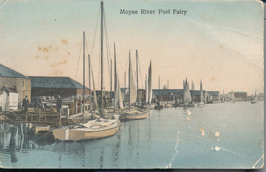
Photograph - Wharves and harbour on the Moyne River at Port Fairy, c.1926
Henry Beater Christian (1886-1962) , was a descendant of one of the earliest settler families in Kew. Employed at the Kew Asylum as a 'public servant', he was a skilled amateur photographer, photographing numerous scenes in Kew and on his travels around Victoria. The majority of his photographs date from 1916 to 1929. His finest photographs are housed in two photograph albums. Digital copy of a photograph from page 24 of the 47-page photograph album containing 261 gelatinous silver images, loaned by Diane Washfold with permission given to digitise and hold a copy in our collection. In what would appear to be one of his rare trips to coastal Victoria, Henry Christian took this photo of the wharves and harbour on the Moyne River at Port Fairy in c.1926. The photograph shows the buildings along the river and parts of the township in the distance. henry beater christian (1886-1962), landscape photography, christian-washfold collection, photograph albums, moyne river, port fairy (vic.) -
 Port Fairy Historical Society Museum and Archives
Newspaper - Newspaper article
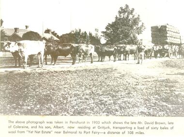
This photo was taken in Penshurst in 1903 which shows the late David Brown, late of Colerain Balmoral and his son, Albert, now residing at Gritjurk, transporting a load of sixty bales of wool from “Yat Nat Estate” near Balmoral to Port Fairy —a distance of 108 miles.Black and white photograph from a newspaper article with a large wool laden wagon with 14 bullocks yoked up The above photo was taken in Penshurst in 1903 which shows the late David Brown, late of Colerain Balmoral and his son, Albert, now residing at Gritjurk, transporting a load of sixty bales of wool from “Yat Nat Estate” near Balmoral to Port Fairy —a distance of 108 miles.transport, rail, road, bullocks, wagon, carrier, penshurst, balmoral, albert brown, david brown, wool bales, yat nat estate, gritjurk -
 Port Fairy Historical Society Museum and Archives
Photograph, Alex Wilkins, c1940's
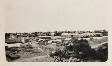
This photograph depicts Port Fairy streets in the 1940's showing Cox Street, William Street,Lower half of Bank Street River and sea. The Gas works are visible on Cox StreetThis photograph taken in the 1940's is significant because of the detail of that is shows regarding the set out of the streets and the vacant landblack and white photograph of the streets of Port Fairy2 stamps - ALEX WILKINS Photographer Warrnambool, Mrs O.G. Powell Phone 883 Port Fairy.( No 6 set over Sect 4) 4-6 streets, moyne river, port fairy, cox street, william street, gas works -
 Port Fairy Historical Society Museum and Archives
Photograph, A.C. Aberline
Fancy Dress for Hospital BallShows the humour of the era showcasing many different fancy dress costumes.Black and white photograph mounted on grey card, rectangular, featuring people representing the hospital dressed in for a fancy dress ballAberlinefancy dress, hospital ball, hospital -
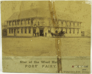 Port Fairy Historical Society Museum and Archives
Photograph, davis, Star of the West Hotel Port Fairy, 1888
Photograph taken for Charles L Tischler when he became the licencee of the Star of the West in 1888. Records show that he was only licencee for 1 year. Photograph of Star of the West hotel when Charles L Tischler was the licencee and was a depot for Cobb and Co and had permission to be open until midnight to service travellers.Albumen coloured photograph of Star of the West Hotel in 1888Written in Pen underneath photograph - Davis Photo - Port Fairy Printed - Star of the West Hotel PORT FAIRY Right bottom corner -C L. Tischler, Propr a red X in Texta Museum number- 62.03.626 crossed out in pen -1888charles l tischler, hotel, licencee -
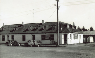 Port Fairy Historical Society Museum and Archives
Photograph, 1960's
This photograph shows the hotel without the later addition of the wooden stump to the corner near the bar door. The stump relates to the story of early closing time in the late 1800's early 1900's when if the publican thought it was safe he would put a lit lantern out on the wood chopping stump to indicate that he was still open for business.This photo is significant because it shows the building without the "stump" out the front which was a later addition.Black and white photograph of The Caledonian Hotel taken from the diagonal cornerWritten in ink -The Stump Hotelthe stump, hotel, caledonian hotel, bank street, james street -
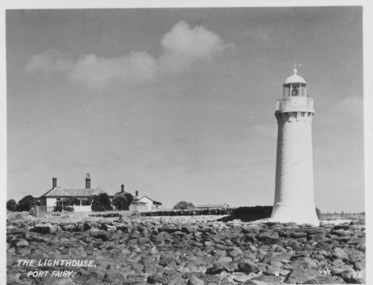 Port Fairy Historical Society Museum and Archives
Postcard, The Lighthouse, Port Fairy
Picture shows Lighthouse and the Lighthouse Keepers cottage. Hugh Haldane painted the lighthouse white so this photograph was taken after 1929Black and white photograph of the light house with the lighthouse keepers cottages in the backgroundThe Lighthouse, Port Fairy- V.6lighthouse, maritime safety, cottage -
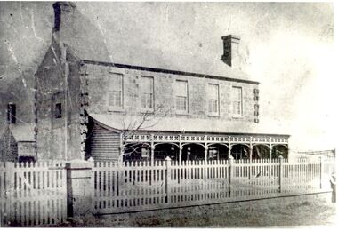 Port Fairy Historical Society Museum and Archives
Photograph
The land for this building was granted to the Benevolent Society by James Atkinson in 1850. Tenders were being called for a new "Benevolent Asylum" in 1855, the foundation stone having been laid and by 1856 the first part of the Hospital was completed. This photo taken in 1860 shows the very first building made from local bluestone. The hospital is thought to be the first such building in VictoriaBlack and white photograph of Bluestone 2 story building with verandah and paling fencehospital, institution -
 Port Fairy Historical Society Museum and Archives
Photograph, circa 1932
The land for this building was granted to the Benevolent Society by James Atkinson in 1850. Tenders were being called for a new "Benevolent Asylum" in 1855, the foundation stone having been laid and by 1856 the first part of the Hospital was completed. This photograph shows the completion of early extensions and how the Hospital has expandedSepia photograph of Buildings at the back of the hospital with large tank standhospital, institution -
 Port Fairy Historical Society Museum and Archives
Photograph
The land for this building was granted to the Benevolent Society by James Atkinson in 1850. Tenders were being called for a new "Benevolent Asylum" in 1855, the foundation stone having been laid and by 1856 the first part of the Hospital was completed. this photograph shows there have been extensions to both sides of the hospital by this time 1920Black and white photograph of Exterior of hospital with verandah stone fence and gates two cars hospital, institution, villiers street, benevolent asylum, health service -
 Port Fairy Historical Society Museum and Archives
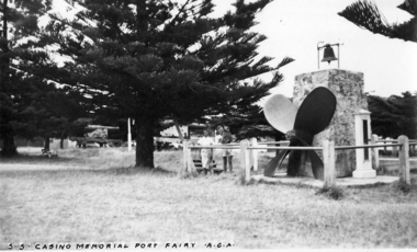
Photograph, A.C. Aberline, SS Casino Memorial Port Fairy, 1950's
SS Casino Memorial here the photograph shows the barometer which is now missing & the two large cannons which have occupied positions at the Gardens oval and now reside in the fort on Battery hill. Black and white photograph of the s.s.Casino memorial S.s.Casino Memorial Port Fairy A.C.A.memorial, s.s.casino, cannon, barometer -
 Port Fairy Historical Society Museum and Archives
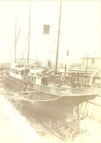
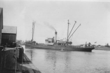
Photograph, s.s.Casino
This photograph show the ship in dry dock (possibly Melbourne) for maintenance. The steamer S.S.CASINO was much loved by the whole Port Fairy community- with the possible exception of some of the fishermen whose boats she ran down! Transport of the large quantities of wool, potatoes, onions, grain, sheep, cattle and other produce grown on the rich lands of the Western District Belfast was served by a plethora of shipping, both sail and steam, but only one of the steamers then in the regular trade (S.S. DAWN) would ever be able to get up the river and reap the cost savings of loading against a wharf. It was not unusual for four steamers to be anchored in the bay at once and for seven or eight different steamers to call during a week. A number of inter-colonial steamers also called to pick up produce for delivery to Melbourne, Sydney and Adelaide. Production in the Western District was increasing and virtually all of that production had to go through one of the western ports in order to reach markets. By 1882 a meeting 15ft. March, 1882, in the office of auctioneer, J.B. HoIden in Cox Street took action and it was unanimously resolved - that the Belfast & Koroit Steamship Company be formed with a capital of £20,000 in 10,000 shares of £2 each". A number of steamers were offered by letter to the fledgling company, including the new and almost sister ships, CASINO and HELEN NICHOLL. The CASINO was on her delivery voyage from England was due to arrive in Warrnambool to load potatoes for Sydney and, initially, arrangements were made for her to call into Port Fairy for inspection by the BKNS Co directors. She eventually proceeded direct to Warrnambool and the Directors inspected her there. Without hesitation they purchased her even though they had to raise a large bank loan to do so. The CASINO arrived in Port Fairy on Saturday, 29th. July, 1882, steaming triumphantly up the Moyne River, and was greeted by crowds, many of whom had driven in from the surrounding countryside, which gave her “loud ringing English cheers". By 1884 the CASINO could not carry all the cargoes available to her and in December of that year the company purchased the new steamer BELLINGER to provide additional capacity. She helped to open up the intermediate ports of Lorne, Apollo Bay and Port Campbell, but the BELLINGER was not really suitable for the trade and she was sold in 1887, leaving the CASINO to operate alone -as she was to do for almost all of the next 45 years. The opening of the railway in 1890 decreased the cargo available to the steamers and the economic depression of the early 1890's worsened the situation. The weak soon began to fall by the wayside and when the Portland & Belfast SN Co. decided to go into liquidation in April 1895, the Belfast & Koroit Company bought the Portland Company's steamer DAWN on advantageous terms, a substantial part of the payment being in BKSN Co shares. The BKNS Co and the Howard Smith Line came into direct head to head competition and nearly forced the BKNS Co out of existence. Cargo dropped to such an extent that in 1899, they reached agreement that only one ship would run and that the ship which ran would pay a weekly amount to the competitor to stay out of the trade. This controlled service ceased in1909, and competition intensified when Howard Smith placed the newly built, larger steamer EUMERALLA on the run. The BKNS Co survived this competition and even prospered during it partly by extending on a more regular basis, the CASINO'S voyages to South Australian ports Port Macdonnell, Kingston, Beachport, Robe and, on occasions Adelaide. There were setbacks when, on 20 October 1924, CASINO went ashore at the Kennett River, near Apollo Bay, and again, in February l929, when she struck a submerged object at Warrnambool and had to be beached. The railways placed great competitive pressure on the small steamship company and this pressure was intensified when the Great Depression slashed the market for Western District produce, BKNS Co struggled on, paying dividends in most years, and the company planned a big celebration for the CASINO'S fiftieth anniversary in the trade on 29th July, 1932. Disaster struck soon after 9 o'clock on the morning of Sunday I0 July, 1932 when the CASINO was lost at Apollo Bay together with the lives of 10 crew members. Black and white photograph of ship in dry dockship, boat, sea, river, industry, belfast and koroit steam navigation company -
 Port Fairy Historical Society Museum and Archives
Photograph, TSS Coramba
Used primarily for shipping freight between Port Fairy and Melbourne, the Coramba was lost off Phillip Island during a storm on 30th November 1934. Her location was not discovered until 29th May 2011. This photograph is unique because it shows the ship using the turning basin in the Moyne River.B&W photograph ship, boat, sea, river -
 Port Fairy Historical Society Museum and Archives
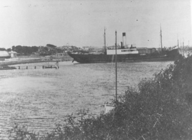
Photograph
This shows the S.S.Wannon turning in the specially widened part of the river called the "turning basin" before slipping into her berth at the Belfast and Koroit Steam Navigation Company wharfBlack and white photograph of SS Wannon turning in the Moyne Rivership, boat, sea, moyne river, belfast and koroit steam navigation company, turning basin -
 Port Fairy Historical Society Museum and Archives
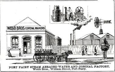
Drawing - large picture, Webb Bros Cordial Factory
This lithograph shows William Webb's Cordial and Aerated Waters factory on William Street. An 1887 plan shows three buildings forming part of the factory. Black & white etching of Large building of Webb Bros Cordial factory with delivery cart out front and lower wooden buildings to the leftPort Fairy Steam Aerated Water and Cordial Factory Webb Bros. William Street Port Fairyfactory, business, shop -
 Port Fairy Historical Society Museum and Archives
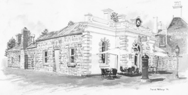
Photograph - Drawing, Sketch of Borough Chambers
Originally the Port Fairy Post Office built by Captain John Mason in 1865 in place of a wooden structure which he also built back in 1857. It then became the Port Fairy Borough Chambers in 1882 and the drawing shows the building inhabited by a Restaurant called "Lunch" c1990's. It is now the home of another Restaurant called 'Le Edera'.Black and white photograph of a drawing shop, commercial, borough chambers, borough council, port fairy, restaurant, 'lunch', 'le edera' -
 Port Fairy Historical Society Museum and Archives
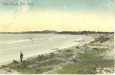
Photograph - Postcard, East Beach Port Fairy
... Street Port Fairy great-ocean-road Shows old pier and remnants ...Shows old pier and remnants of wharf railEvidence of former pier and wharf railB&W PhotographEast beach Port Fairybeach, seascape, pier -
 Port Fairy Historical Society Museum and Archives
Postcard - Photograph, A.C. Aberline, Fishing boats in Mayne River
... Street Port Fairy great-ocean-road Shows the fishing fleet ...Shows the fishing fleet in the harbour this postcard was used to send a message home to family and friends regarding their stay in Port FairyA photograph of a busy fishing town and tourist mecaHand coloured photograph/postcardMoyne River Port Fairyharbour, fishing fleet -
 Victorian Bands' League
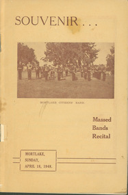
Programme, Souvenir...Mortlake Citizens' Band : Massed Bands Recital. Mortlake, April 18, 1948, 1948
This programme dates from 1948 when the Mortlake Citizens' Band held a Massed Bands Recital in Mortlake. A number of bands from the South-West region of Victoria participated with the event comprising of a March and various massed bands items. The programme is extremely detailed as to times bands were playing and also includes an amount of advertisements for local Mortlake businesses.This small programme is significant as it shows how a country town held a massed bands festival and hosted regional brass bands. It is also significant as it shows the amount of local businesses who advertised in the programme, and what kinds of businesses they were. This was obviously a major event for the town and the local band, and it appears that it was a success.Programme printed on paper with a card cover.There are some inscriptions and corrections in the programme primarily on the brief history of the Mortlake Citizens' Band.hamilton, terang, warrnabool, colac, camperdown, port fairy, mortlake, victorian bands' league -
 Port Fairy Historical Society Museum and Archives
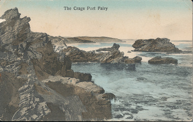
Postcard, A.C. Aberline, The Crags
This photograph is of “The Crags” an area on the coast half way between Port Fairy and Yambuk. The name is an abbreviation of McKechnies Craigs/Crags owners of property in the vicinity. it is close to ancient aboriginal campsites but these are not accessible to the public. Because of the nature of the geology in this area this photograph shows a seascape that it is not possible to see now.Hand coloured photograph used as postcardThe Crags Port Fairyseascape, sea, beach, the crags, mckechnie’s crags or craigs -
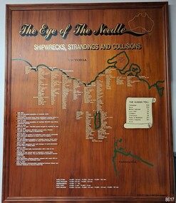 Flagstaff Hill Maritime Museum and Village
Artwork, other - Shipwreck Board, The Eye of the Needle: Shipwrecks, Stranding's and Collisions, ca 2002
The Shipwreck Board is a feature of Flagstaff Hill Maritime Museum and Village/ its subject is explained briefly in the Museum's handbook, The Flagstaff Hill Navigator, published in 2008: - "Known as the ‘Eye of the Needle’ the treacherous entrance to Bass Strait is littered with the wreckage of large international vessels and smaller sail and steam craft used in coastal trade. The vessels bringing emigrants and cargo to Australia found the western entrance to Bass Strait the most dangerous part of their voyage. They had to thread their way between the southern point of Victoria (Cape Otway) and the northern point of King Island, a stretch of water less than 90 km wide. Many smaller coastal vessels were lost at Portland, Port Fairy, Warrnambool and Apollo Bay which are not safe harbours in certain weather conditions. "The Shipwreck Board shows shipwrecks, strandings and collisions which occurred in this area up to the year 1940. Wrecks are identified by a yellow light and collisions/strandings by a green light. These lights also identify the decade the wreck occurred by lighting up when the relevant decade button is pushed. Interesting happenings of the decades are listed next to the buttons." The Shipwreck Board's demonstration of The Eye of the Needle is an interactive visual display that helps teach the perils and dangers faced by early settlers in Victoria. It tells of the vast number of lives lost. It lists the names of many infamous shipwrecks and significant events.The large stained and lacquered timber board is mounted in a timber, frame. It is painted with a small sketch of Australia, and an enlarged outline of the southern coast of Victoria, King Island and the North West coast of Tasmania. The interactive display highlights the shipwrecks, standings and collisions suffered by many vessels as they navigated the 'Eye of the Needle', a narrow stretch of Bass Strait. The locations of the Lighthouses are pinpointed. Lists of groups of ships are below the coastlines. A painted scroll shows eight major shipwrecks with the number of lives lost for each one. A table shows historical facts associated with the decades from pre-1830 to 1940. A system of coloured lights compares the decades with the vessels that suffered damage. The board was created by artist and signwriter, Alex O'Flynn Computer Signs.flagstaff hill, maritime museum, maritime village, shipwreck coast, eye of the needle, shipwreck locations, bass strait, basses strait, king island, north west tasmania, south coast of victoria, cape otway, victorian lighthouse, king island lighthouse, strandings, coastal tracers, emigrant ships, sea trade, 1930s-1940s, shipwreck board, the eye of the needle, collosions, alex o'flynn, alex o’flynn computer signs, shipwrecks of western victoria -
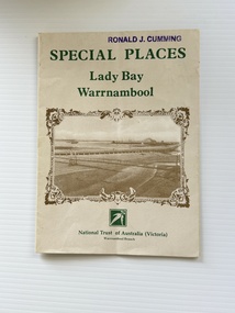 Warrnambool and District Historical Society Inc.
Pamphlet - Special Places Lady Bay Warrnambool, Philprint Warrnambool, 1989
This pamphlet was produced for the Warrnambool Branch of the National Trust of Australia (Victoria) for Heritage Week, April 16-23, 1989 and contains information written by Warrnambool residents about their locality. This was a co-operative venture by people with a common interest in protecting the natural environment near their home. Areas covered in the written information include: Formation of the Coast, Archaeological survey, Gunditjmara History, vegetation, history and recreational uses of the Lady Bay area. The map shows special places of interest including past and present navigational aids, sites of shipwrecks and other historical places of interest. The Warrnambool Branch of the National Trust was originally formed in March 1969 and merged with the Port Fairy Branch in late 1970. In October 1979, the Warrnambool Branch was reformed and operated into the late 1990's. This is an example of a publication produced by the Warrnambool Branch of the National Trust Australia (Victoria). It provides historical information and perspectives of the recreational uses in and around Lady Bay Warrnambool.An A2 piece of buff coloured thick paper folded into eight to make an A5 pamphlet. The front cover has green printing with the National Trust symbol of three eucalyptus leaves in green. There is a brown sepia photograph showing a view across Lady Bay with the suspension bridge across the Merri River in the foreground, Viaduct Road in the middle ground and the breakwater in the background. There is a purple inked stamp on the top right hand corner. The rear cover has brown writing and includes logos of bodies who assisted with the publication. There is a brown line drawing of the viaduct and pier at the Warrnambool Breakwater. The inside of the unfolded pamphlet contains a map of Lady Bay and adjacent area showing places of interest and shipwrecks marked in red circlesFront cover: Special Places Lady Bay Warrnambool National Trust of Australia (Victoria) Warrnambool Branch Ronald J. Cummingwarrnambool, lady bay warrnambool, national trust australia victoria warrnambool branch, heritage week 1989, lady bay shipwrecks -
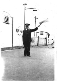 Hymettus Cottage & Garden Ballarat
Photograph, Port Fairy Station
The photograph shows the station master Mr John (Jack) Taffe at Port Fairy, Victoria in the late 1950s signalling for the train to depart using flag and bell. The Port Fairy Railway station was closed twenty years later in 1977.port fairy, railway history, taffe, stationmaster, railway station closures, trains, train station. -
 Flagstaff Hill Maritime Museum and Village
Map - Survey Map, F.F. McGovern, Yangery - County of Villiers, 1884
A surveyor was employed to measure the land designated as Yangery, County of Villiers, in the Borough of Warrnambool. The area on the map is similar to the earlier Farnham Survey undertaken by William Rutledge in the 1850's. Warrnambool was a Borough between 1863-1883. Coutours, waterways, sea and other significant points are shown. The distances are accurately measured. This survey map was used for planning future land sales, recreation areas and roads. WILLIAM RUTLEDGE (1806-1876) William Rutledge surveyed the land known as Farnham in southwest Victoria in 1843. His tenants made him a profitable business from working the land there. In 1863 Rutledge moved from nearby Port Fairy to Farnham and became very successful in breeding sheep, which he imported from J.R. Kirkham of Lincolnshire, England. He also bred horses on his land. The survey map of Yangery is important for its connection with renowned surveyor William Rutledge. The map shows the growth of landholders in the district when compared to the original Rutledge survey of the 1850's.Survey map of Yangery, titled "Yangery - County of Villiers". Printed on white paper, mounted on brown paper. c. 1863-1876. Comments printed on the Map include; Special Survey by William Rutledge, Photo-lithographed at the Department of Lands and Survey, Melbourne by W.J. Burson, Price 1/- [one shilling]. Scale is in Chains. Map has boundaries of Koroit Borough, Meerai, Purnim, Wangoom, Borough of Warrnambool, Mentions the Proposal of Tower HIll for Public Recreation. The map names the owners of the land at that time. Hand written pencil marks and figures and "Sauls fence" drawn on map. Hand written pencil markes and figures and "Sauls fence" drawn onto map. "For Department Use only". "Scale: 8 chains to 1 inch" flagstaff hill, warrnambool, shipwrecked-coast, flagstaff-hill, flagstaff-hill-maritime-museum, maritime-museum, shipwreck-coast, flagstaff-hill-maritime-village, county of villiers map, yangery district, w.j. burson, borough of warrnambool, koroit, purnim, meerai, wangoom, proposal of tower hill for public recreation, special survey by william rutledge, william rutledge, farnham, lincolnshire sheep, clydesdale -
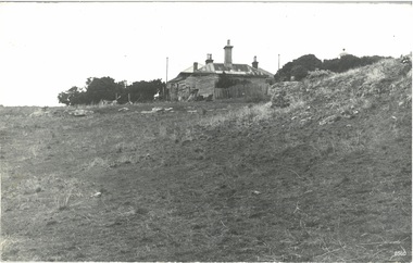 Flagstaff Hill Maritime Museum and Village
Photograph - Historical, Port Fairy, Late 19th to early 20th centuries
The late 19th to early 20th century stone cottage with weatherboard extensions. From research, it has been determined that the cottage was the Port Fairy (Belfast) Lighthouse Keepers cottage. The dome roof in the background indicates a lighthouse, in which case the cottage would have been the living quarters for a lighthouse keeper and assistant keeper. The narrow poles could have been for signals and antennae. The object on the rock stack looks like a large metal milk can.The photograph shows a typical late 19th to early 20th century cottage, abandoned at dilapidated for many years. Black and white rectangular photograph mounted on card. The image shows a dilapidated stone cottage with an old picket fence. Extending behind the stone cottage are gabled roofs above weatherboard walls. The cottage has corrugated roof sheets of different colours, and four chimneys, three with chimney pots. From research, it has been determined that the cottage was the Port Fairy (Belfast) Lighthouse Keepers cottage. Near the fenceline on the left, a corrugated water tank is positioned below a pipe joined to the roof gutter. Nearby are a timber shed and timber walls or screens. In the background are two tall narrow poles with spheres on top, higher than the cottage, with one pole on each side, the left one attached to the building. A domed roof with a knob on top is on the right behind trees. Several angular shapes appear on the horizon on the left, one almost hidden by the trees. The foreground is rocky and slopes uphill on the right. At the foot of the slope is a stack of closely fitted rocks with an object shaped like a milk can on top and an object to its left that is like an open grid. Handwritten Inscriptions are on the reverse side of the photograph.Pencil on board: " D9 / 200 x 150" Pen on sticker: "52"flagstaff hill maritime museum and village, warrnambool, great ocean road, shipwreck coast, cottage, lighthouse, iron roof, stone building, picket fence, water tank, weatherboard building, 19th century cottage, early 20th century cottage, abandoned cottage, antenna, chimneys, milk can -
 Flagstaff Hill Maritime Museum and Village
Print - Vessel, Steamship, A.V. Gregory, SS Casino off Point Lonsdale, ca. 1899-1932
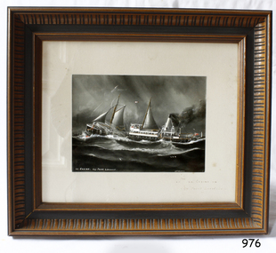
Print of a picture of the S.S. Casino, This print is from an original painting by the Australian marine artist A V Gregory (1867-1957), also known as Arthur Victor Gregory. Gregory lived and worked in South Melbourne. He took over the Gregory Studio owned by his father, George Frederick Gregory, painting actively between 1899 and 1932. He usually signed his works as ‘A V Gregory’. Some of his original works have been sold for thousands of dollars. The S.S. Casino was a passenger and freight steamer built in Dundee, Scotland, in 1882 for the Newcastle and Hunter River Steam Navigation Company of N.S.W. She weighed 425 tons gross with a length of 160.4 feet, beam of 24.1 feet and a depth of 10.2 feet. She had saloon accommodation for 35 people, a fore cabin for 25 more people, and she carried 300 tons of cargo. While on her delivery journey on May 30th 1882 the S.S. Casino called in at the Port of Warrnambool for coal ., narrowly escaping going ashore in gale force winds due to the quick action of the pilot. At that time, still at anchor, she impressed the directors of the Belfast and Koroit Steam Navigation Company so much that they bought her immediately; she was ideal for trade along the West Coast of Victoria. (The Belfast and Koroit Steam Navigation Company was first managed by Messers. Saltau and Osburne and after the passing of Mr. Osburne, by produce merchants Messers H. Sautau and Sons, who had a hay and corn store and shipping agency on the corner of Liebig and Koroit Streets in Warrnambool. ) The S.S. Casino became “the most famous steamer to operate in Victorian waters along the West Coast” by author Jack Loney. Captain Boyd was her first Master, followed by Captain Chapman, who stayed with her from 1890 until 1924. Captain W. Robertson followed for a short term, and then Captain Middleton then took command from 1925 - 1932. The S.S. Casino had several mishaps during her life. One was on 3rd January 1898 when she collided with the S.S. Flinders in Apollo Bay with minor damage. Another was on 24th October 1924 when she grounded on a reef at Point Hawdon near Grey River and most of her cargo (of Christmas goods) had to be dumped into the sea. Then in February 1929 she was ‘holed’ when she struck a submerged object as she entered Lady Bay, Warrnambool. On the morning of 10th July 1932, after attempting to berth at Apollo Bay jetty in heavy seas, Captain Middleton decided to take her out into the bay and wait until the seas abated. It was not realised that the anchor used to steady her as she manoeuvred to her berth had pierced her hull. She put about and headed for the beach but sank. Captain Middleton and nine others lost their lives; nine people were rescued including the two female passengers. Captain Middleton had been in charge of the S.S. Casino for seven years. He was the first ship’s Master to lose his life in a shipwreck in the West Coast trade. In the years following the turn of the century, the S.S. Casino remained the only regular trader with normal passenger accommodation along the West Coast. From 1882 she had made at least 2,500 voyages on the one run. Flagstaff Hill’s collection has a photograph of a portrait of Captain Chapman, , a ship model of the S.S. Casino that shows both forms of power under which she sailed, steam and sail. The ship is painted green and flies three flags. The inscription across the case of the ship model, incorrectly dated, tells the sad story of the wreck of the ship and the loss of lives on July 10th 1932 at Apollo Bay. A print in the Collection shows S.S. Casino underway in the heavy sea off Point Lonsdale, another two photographs show her at the Port of Warrnambool, leaving from the Breakwater in Lady Bay and another identifies the S.S. Casino as a ship from the Belfast and Koroit Steam Navigation Company. (Belfast is the original name for the township of Port Fairy).This print of the S.S. Casino is of significance for its association with the coastal trader S.S. Casino. The wreck of the S.S. Casino is considered an important part of Victorian and Australian cultural heritage and as such has been declared and protected as an Historic Shipwreck under State and Commonwealth Law in the Commonwealth Historic Shipwrecks Act (1976). The detailed image of the vessel depicted in this print shows one of the many sail and steam vessels painted by the renowned Victorian marine artist A V Gregory, whose original works are highly valued today by marine collectors.Print with hand-painted watercolour highlights depicting the port side steamship SS Casinounderway in a heavy sea, merchant flag flying at the stern. Mounted in a decorative wooden frame behind glass. The original painting was by A V Gregory. The title of the picture is repeated in handwritten words on the matte below the artist's signature on the print.Signed "A V Gregory" Hand painted title "SS Casino off Point Lonsdale"flagstaff hill, flagstaff hill maritime museum and village, warrnambool, maritime museum, maritime village, great ocean road, shipwreck coast, newcastle and hunter river steam navigation company, belfast and koroit steam navigation company, h. sautau and sons, s.s. casino, west coast trader s.s. casino, victorian coastal trader, captain boyd, captain w. robertson, captain chapman, captain middleton, apollo bay shipwreck, s.s. casino at lady bay warrnambool, saltau and osburne, a v gregory, arthur victor gregory, melbourne artist -
 Flagstaff Hill Maritime Museum and Village
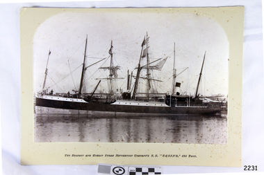
Photograph - Vessels, Sailing Ships, The Belfast and Koroit Steam Navigation Company's S.S. "Casino, 425 Ton, Late 19th to early 20th centuries
This black and white photograph shows the image of the coastal trading vessel S.S. Casino, with both sail masts and steam funnel. Men in hats are clearly visible on deck. The ship is in calm water and only light rigging is on the masts. Other vessels are in the background. Photograph is taken 1882-1932. The S.S. Casino was a passenger and freight steamer built in Dundee, Scotland, in 1882 for the Newcastle and Hunter River Steam Navigation Company of N.S.W. She weighed 425 tons gross with a length of 160.4 feet, beam of 24.1 feet and depth of 10.2 feet. She had saloon accommodation for 35 people, forecabin for 25 more people, and she carried 300 tons of cargo. While on her delivery journey on May 30th 1882 the S.S. Casino called in at the Port of Warrnambool for coal ., narrowly escaping going ashore in gale force winds due to the quick action of the pilot. At that time, still at anchor, she impressed the directors of the Belfast and Koroit Steam Navigation Company so much that they bought her immediately; she was ideal for trade in along the West Coast of Victoria. (Belfast is the original name for Port Fairy, South West Victoria. The Belfast and Koroit Steam Navigation Company was first managed by Messers. Saltau and Osburne and after the passing of Mr. Osburne, by produce merchants Messers H. Sautau and Sons, whose had a hay and corn store and shipping agency was on the corner of Liebig and Koroit Streets in Warrnambool. ) The S.S. Casino became “the most famous steamer to operate in Victorian waters along the West Coast” by author Jack Loney. Captain Boyd was her first Master, followed by Captain Chapman, who stayed with her 1890 until 1924. Captain W. Robertson followed for a short term, then Captain Middleton then took command 1925 - 1932. The S.S. Casino had several mishaps during her life. One was on 3rd January 1898 when she collided with the S.S. Flinders in Apollo Bay with minor damage. Another was on 24th October 1924 when she grounded on a reef at Point Hawdon near Grey River and most of her cargo (of Christmas goods) had to be dumped into the sea. Then in February 1929 she was ‘holed’ when she struck a submerged object as she entered Lady Bay, Warrnambool. On the morning of 10th July 1932, after attempting to berth at Apollo Bay jetty in heavy seas, Captain Middleton decided to take her out into the bay and wait until the seas abated. It was not realised that the anchor used to steady her as she manoeuvred to her berth had pierced her hull. She put about and headed for the beach but sank. Captain Middleton and nine others lost their lives; nine people were rescued including the two female passengers . Captain Middleton had been in charge of the S.S. Casino for seven years. He was the first ship’s Master to lose his life through shipwreck in the West Coast trade. In the years following the turn of the century the S.S. Casino remained the only regular trader with normal passenger accommodation along the West Coast. From 1882 she had made at least 2,500 voyages on the one run. Flagstaff Hill’s collection has a photograph of a portrait of Captain Chapman, , a ship model of the S.S. Casino that shows both forms of power under which she sailed, steam and sail. The ship is painted green and flies three flags. The inscription across the case of the ship model, incorrectly dated, tells the sad story of the wreck of the ship and the loss of lives on July 10th 1932 at Apollo Bay. A print in the Collection show S.S. Casino underway in heavy sea off Point Lonsdale, another two photographs show her at the Port of Warrnambool, leaving from the Breakwater in Lady Bay and another identifies the S.S. Casino as a ship from the Belfast and Koroit Steam Navigation Company. (Belfast is the original name for the township of Port Fairy). This photograph is significant because of its association with the coastal trader S.S. Casino and its significance to trade along Victoria's West Coast in the late 19th and early 20th century. It was taken 1882-1932 The wreck of the S.S. Casino is considered an important part of Victorian and Australian cultural heritage and as such has been declared and protected as an Historic Shipwreck under State and Commonwealth Law in the Commonwealth Historic Shipwrecks Act (1976). Photograph, black and white, taken 1882-1932. Foreground is vessel SS Casino, the Belfast and Koroit Steam Navigation Company's coastal trading ship. The ship, in calm water, has light rigging on its masts and also a steam funnel. One lifeboat is visible. People are on the deck. The background shows other vessels.Under the photograph "The Belfast and Koroit Steam Navigation Company's S.S. "Casino," 425 Tons"flagstaff hill, warrnambool, shipwrecked coast, flagstaff hill maritime museum, maritime museum, shipwreck coast, flagstaff hill maritime village, great ocean road, newcastle and hunter river steam navigation company, belfast and koroit steam navigation company, h. sautau and sons, s.s. casino, west coast trader s.s. casino, victorian coastal trader, captain boyd, captain w. robertson, captain chapman, captain middleton, apollo bay shipwreck, s.s. casino at lady bay warrnambool, saltau and osburne -
 Flagstaff Hill Maritime Museum and Village
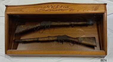
Weapon - Historic Rifles, Royal Small Arms Factory, 1877-1900
Martini-Henry Artillery Carbin rifles were made by the Royal Small Arms Factory at Enfield, Britain, from 1877 until 1900. Many were distributed to the British Colonies, including this pair, which was allocated to the Woodford Police, Victoria Police District of Warrnambool, Southwest Victoria. The Carbine model rifles were shorter than the standard rifles and more suited to mounted police and troopers. It is likely that in the early 20th century, Victoria Police replaced the two carbines with more modern firearms, and the outdated guns were stored in the stables. The rifles were left there and likely forgotten about due to changes in police staff. In 1915, police authorities announced that they would be replacing patrol horses with bicycles and would also close some smaller police stations. This affected Woodford Police Station, which closed in 1917. The forgotten firearms remained in the stables and were noticed by schoolboy Robert Jellie in 1940 and seen again in 1946. In 1995, the property was sold by the Education Department to a private owner. The Woodford Community donated the pair of Martini-Henry Carbines to the Victoria Police Museum in the late 1990s for mounting and display, which was funded by the Victoria Police Historical Society Inc. The decorative wood and glass display case and frame were designed to preserve the significant history of the guns. On November 1st 1999, the display was presented to Warrnambool Police and the local community due to the historical significance of the Woodford Police Station. In 2025, these items were formally deaccessioned by the Victoria Police Museum, and ownership was transferred to the Warrnambool Police Station. On March 10th, 2025, the display was transferred to Flagstaff Hill Maritime Museum and Village, where the historical story of the Martini-Henry Carbines could continue to be preserved and accessed by local families, the community, visitors to the area, and online visitors. WOODFORD POLICE: - The small settlement at Woodford was established in the 1840s around the Merri River where there was a ford across the water and a bridge from 1848 to 1851. The area was settled very early in Victoria’s history, and the river crossing provided travellers with access to the early route between Port Fairy (named Belfast at that time), Warrnambool and Melbourne. Occasionally, a Warrnambool police trooper would ride through Woodford and the district. In December 1854, Woodford Police barracks and stables were built on the hill by the Merri River on Bridge Road east, where Jubilee Park now stands. A local mounted trooper kept law and order in the area. In 1856, a lock-up was installed, and the first Woodford Police Station was in action in 1857. By 1871, the police station had been moved from the hill to land across the Merri River bridge, on the southern side of Bridge Road west, near Mill Street. In 1890, the police residence there was replaced by a stone Edwardian-style building with the stables and lock-up behind it and the old police station at the rear. The police continued to have a presence in Woodford until it was closed by the Police Commissioner in July 1917 for economic reasons. The residence was used for government housing until 1923, when it was taken over by the Education Department for the school teacher’s home. In 1995, it became privately owned. THE MARTINI-HENRY ARTILLERY CARBINE: - The Martini-Henry rifles were made in Britain from 1871 at the Royal Small Arms factory at Enfield and were stamped with the symbol of the Royal Cipher (Crown over VR) over ENFIELD to identify their origin. They were named after two of several people who helped design this method: Swiss Friederich von Martini and Scotsman Alexander Henry. The design was breech-loaded, and the inner barrel was rifled. A thumb rest was incorporated into the top right of the bullet receiver’s chamber. The small teardrop lever on the right side of the rifle showed whether the rifle was ready to be shot. In 1877, the shorter, lighter-weight Carbine version of the firearm was produced for mounted troops and artillery. Its official name was “Carbine, B.L., Rifled, Martini-Henry.” The bullets were slightly lighter in weight than those used for the longer rifle. The sight position was adjusted for the shorter gun, and wings were added to the sight on the tip, making it easier to slide the rifle back into a saddle bag. Some of the later Carbines also had leather sight covers screwed to the stock to prevent them from catching on the saddle bags. The Carbines had accessories available, such as barrel extensions with bayonets and swivels for adding slings. The Martini-Henry Carbine designs were later modified to fire the British .303 ammunition. Eventually, by 1900, the Martini-Henry Carbines were replaced by the Lee Enfield gun design. The pair of Martini-Henry Carbine firearms represents policing in the early pre-1900 days of colonial settlement; Woodford was one of the first townships settled in Victoria, and it had a police presence from 1854 until 1917. The rifles and display provide a historic connection between the location of Woodford and relatives and associates. The carbine rifles show a stage in the evolution of weapon design, adapted to suit mounted troops, and adding features to streamline use and storage. The ammunition was also improved during this progression. The carbines are important for their connection to policing law and order in a remote area. They are significant for their association with the township of Woodford, which was important to travel in the southwest Victoria district, providing access across a river for a road between Port Fairy and Melbourne, and later Warrnambool, and supplying food, goods and accommodation for the travellers. A pair of mounted rifles is mounted behind glass in a timer case, accompanied by a framed display of two photographs and an account of the rifles’ history. The case and display each have a horizontal board with a gently curved edge and carved decorations added. The identical firearms are British-made Martini Henry Carbine breach-loaded rifled guns, supplied by Britain to its Colonial troops from around 1877. The rifles are lever-action, single-shot .500 calibre weapons. They have a teardrop lever on their right side. They were used by Victoria Police mounted troops at the Woodford Police Station, Victoria. The black and white photographs were taken in 1946. The left photograph has a circled area; the right photograph is an enlarged view of the circled area, showing the Woodford Police Station in detail. The printed text is on textured paper with the Victoria Police watermark. It gives a summary of the rifle’s history. There is an inscription on the left photograph. Left photograph, handwritten in white pen: “WOODFORD” Document’s print: “During the late 1840s the small town of Woodford grew around the crossing of the Merri River on the Melbourne/Port Fairy Rad. Woodford was proclaimed a township in 1854 and a police quarters was established there in 1857. The police station remained until 1917 when it was closed and police service from then on was provided from Warrnambool. The building was then used as a school residence and is now privately owned. In !940 Robert JELLIE, then a schoolboy, observed two rifles mounted on the wall of the disused stable at the rear of the old police building. Following the devastating flood of 1946 (see photograph above) the rifles were again seen in the room next to the stable but were not seen again until the building was sold by the Education Department many years later. It was a recognition of the historical value of the rifles which led to their donation to the Warrnambool Police Complex. The rifles have been authenticated by the Victoria Police Armoury as being Victoria Police issue some time before 1900. The rifles are an identical pair of the famous British-made Martini Henry, a .500 inch calibre military weapon widely used by British Colonial troops. Victoria Police and the wider community of Warrnambool are indebted to the members of the Woodford community for their fine gesture in donating the rifles for mounting so that their historical importance can be preserved and they can be displayed for generations to come. This display was funded by the Victoria Police Historical Society Incorporated, and presented on the first day of November, 1999.”flagstaff hill maritime museum and village, great ocean road, shipwreck coast, martini henry, victoria police, woodford police station, rifle, carbine, display case, british, martini henry carbine, breech-loaded, rifled, colonial, single-shot, .500 calibre, weapon, gun, 1877, troops, mounted troops, merri river, victoria police woodford, victoria police warrnambool, victoria police melbourne, police quarters, robert jellie, school residence, stable, 1946 flood, victoria police armoury, identical pair, british colonial troops, victoria police historical society incorporated, woodford, bicycles, found by a schoolboy, edwardian-style building, victoria police museum, warrnambool police station