Showing 107 items matching "proposed extension"
-
 Melbourne Tram Museum
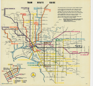
Map, Melbourne & Metropolitan Tramways Board (MMTB), "Tram Route Guide", Jun. 1979
... dated 6/79, showing proposed extension to Bundoora, routes..., titled "Tram Route Guide". Map dated 6/79, showing proposed ...Full colour map or poster printed on clear plastic with an adhesive peel off backing sheets, titled "Tram Route Guide". Map dated 6/79, showing proposed extension to Bundoora, routes with route numbers and names of main destinations. Has notes about the services, weekend and telephone numbers for information. 1979 Two copies held. See Reg Item 3765 for a larger version of this map.trams, tramways, mmtb, map, routes, posters -
 City of Moorabbin Historical Society (Operating the Box Cottage Museum)
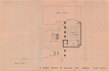
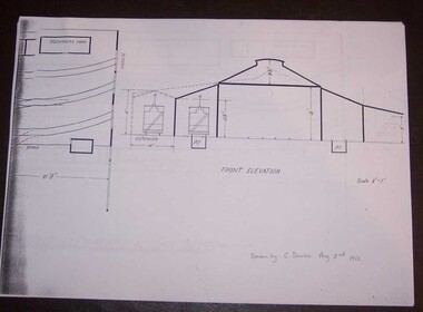
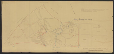
Plan - Extension Plans for St.Anne's Church of England, Moylan Street, East Ormond
... Ormond - proposed plans for extension 2 pages... in 1995. These plans were drawn up to add an extension ...St Anne's Church of England in Moylan Street, East Ormond was closed in 1995. These plans were drawn up to add an extension to the existing church - but it was never built.Example of the progress of the Municipality of MoorabbinArchitectural Drawings for St Annes Church of England East Ormond - proposed plans for extension 2 pagesst anne's church of england, moylan street, east ormond, religion, building plans -
 Ballarat Tramway Museum
Document - Photocopy, Alan Bradley, "Plan and Front Elevation of Car Depot", 2000
... layout, track layout, overall dimensions, a proposed extension..., a proposed extension to hold eleven trailers, a front elevation ...Set of three A3 size photocopies of a drawing held by the Public Records Office Victoria of the Ballarat ESCo Tramway Depot, dated 2/8/1912. Drawn at a scale of 1/16" = 1', shows building layout, track layout, overall dimensions, a proposed extension to hold eleven trailers, a front elevation showing pits, extension (drawn at 1/8" = 1'). On the current tracks, shows the individual track capacities - 26 trams. Drawings copied by Alan Bradley for archives and research.trams, tramways, ballarat, esco, depot, drawings -
 Surrey Hills Historical Society Collection
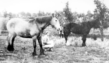
Photograph, Lloyd brothers’ horses near corner of Elgar & Whitehorse Roads, c1930
... a protest regarding the proposed extension of the abattoir. In 1907... a protest regarding the proposed extension of the abattoir. In 1907 ...Lloyd Brothers butchers were located on the NW corner Whitehorse Road and Elgar Roads; previously the premises of Edward Tacey, butcher, established in 1888. There was an abattoir adjoining the premises. In 1901 the Box Hill Reporter contained a protest regarding the proposed extension of the abattoir. In 1907 it was claimed that the development of land in Mont Albert was hindered by the smells and operations of the abattoir. Lloyds also had a shop in Union Road Surrey Hills from 1920-1951, opposite the end of Windsor Crescent.A black and white photograph of a lady squatting in a paddock with two horses.lloyd brothers, butchers, tafe college, elgar road, whitehorse road, mont albert, box hill -
 Whitehorse Historical Society Inc.
Film - Videotape, Eastern Freeway Extension, 1/10/2000 12:00:00 AM
... Video tape of proposed Eastern Freeway extension produced... of Infrastructure Video tape of proposed Eastern Freeway extension produced ...Video tape of proposed Eastern Freeway extension produced by Department of Infrastructure.|Duration - 3 minutes - made October 2000eastern freeway extension, victoria. department of infrastructure -
 Ballarat Tramway Museum
Document - letter re, State Electricity Commission of Victoria (SECV), "Tramways Abandonment" and "Geelong Tramways - Review", 1953
... by the SEC, agreements with Councils, proposed extensions, physical... by the SEC, agreements with Councils, proposed extensions, physical ...Set of letters and memos regarding road damage by buses in West Geelong and a report and notes regarding Geelong Tramways. Includes Early history of Geelong, Creation of the SEC, acquisition by the SEC, agreements with Councils, proposed extensions, physical characteristics of Geelong, the Outlook for Geelong, attempts to define transport future, review of operations, with reference to financial statement, tramcars, fare schedules, employees, trams used, services supplied, passenger density, outlook, costs, possible improvements, and conclusions. Includes tables for income and expenses from 1935 to 1953, and statistics for operations.Demonstrates an extensive appraisal of the Geelong tram system in 1953.Document - 20 foolscap sheets with rounded corners and 1 quarto sheet - typed. held by a brass folding clip in the top left hand corner.tramways, tramcars, operations, secv, geelong, history -
 Whitehorse Historical Society Inc.
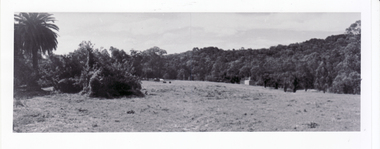
Photograph, Original Site of Schwerkolt Home, 14/02/2001 12:00:00 AM
... . Proposed Eastern Freeway Extension will cut through the treed area.... the topography of site. Proposed Eastern Freeway Extension will cut ...Photographed by Ted Goode to record the topography of site. Proposed Eastern Freeway Extension will cut through the treed area.Three copies of the view of original site of Schwerkolt home - now horse paddock adjoining Cottage Reserve.schwerkolt family, schwerkolt, original cottage site., goode, ted, horse paddock -
 Ringwood and District Historical Society
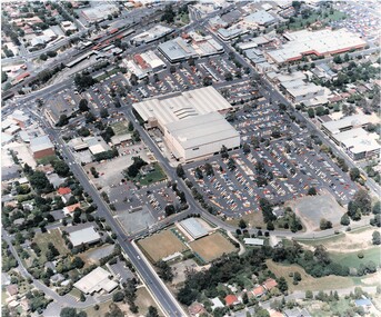
Photograph, Aerial Views of Eastland Precinct, Ringwood, Victoria - circa 1990
... extension proposed to commence in 1992).... extension proposed to commence in 1992). Aerial Views of Eastland ...Two colour aerial photographs overlooking commercial area of Ringwood centred on Eastland shopping precinct (prior to Stage 2 extension proposed to commence in 1992).Aerial Photography by R.J. Moss. -
 Kew Historical Society Inc
Plan - Subdivision Plan, Goldthorns Hill Estate, 1925
... . Buyers were lured by the prospect of the proposed extension... on this plan. Buyers were lured by the prospect of the proposed ...Pru Sanderson, in her groundbreaking ‘City of Kew Urban Conservation Study : Volume 2 - Development History’ (1988), summarised the periods of urban development and subdivisions of land in Kew. The periods that she identified included 1845-1880, 1880-1893, 1893-1921, 1921-1933, 1933-1943, and Post-War Development. These periods were selected as they represented periods of rapid growth or decline in urban development. An obvious starting point for Sanderson’s groupings involved population growth and the associated economic cycles. These cycles also highlighted urban expansion onto land that was predominantly rural, although in other cases it represented the decline and breakup of large estates. A number of the plans in the Kew Historical Society’s collection can also be found in other collections, such as those of the State Library of Victoria and the Boroondara Library Service. A number are however unique to the collection.The Kew Historical Society collection includes almost 100 subdivision plans pertaining to suburbs of the City of Melbourne. Most of these are of Kew, Kew East or Studley Park, although a smaller number are plans of Camberwell, Deepdene, Balwyn and Hawthorn. It is believed that the majority of the plans were gifted to the Society by persons connected with the real estate firm - J. R. Mathers and McMillan, 136 Cotham Road, Kew. The Plans in the collection are rarely in pristine form, being working plans on which the agent would write notes and record lots sold and the prices of these. The subdivision plans are historically significant examples of the growth of urban Melbourne from the beginning of the 20th Century up until the 1980s. A number of the plans are double-sided and often include a photograph on the reverse. The Goldthorns Hill Estate subdivision was first put up for auction in 1925. The subdivision took its name from the mansion ‘Goldthorns’, shown on the plan between Normanby Road and Lady Loch’s Drive. Contemporary advertisements describe forty-three home sites being fro sale, yet only forty-one appear on this plan. Buyers were lured by the prospect of the proposed extension of the Burke Road tram to High Street. Discerning buyers were advised that only one house could be built per allotment, and that houses needed to be constructed of brick, stone or concrete and have a slate or tiled roof.goldthorns avenue -- kew east (vic.), lady loch drive -- kew east (vic.), argyle road -- kew east (vic.), lady brassey drive -- kew east (vic.), campbell street -- kew east (vic.), goldthorns -- kew (vic.), subdivisions -- kew east (viv.), goldthorns hill estate -
Southern Sherbrooke Historical Society Inc.
Menzies Creek Hall records, 1955-2004
... , proposed extensions, undated -floor plan, undated but c.1979 (2..., proposed extensions, undated -floor plan, undated but c.1979 (2 ...Records of the Menzies Creek Hall Committee. Contents: -outgoing correspondence 1955-1971 -outward correspondence 17 Nov 1977-2 Oct 1984 -outgoing correspondence 1991/92, incoming mail in same manila folder -inward correspondence 3 Jul 1978-21 Aug 1981 -minutes March 1972-August 1976 -minute book Nov 1977-22 May 1992 -folder containing minutes and correspondence 1991/2/3 and two passbooks -folder containing minutes, correspondence, etc. 1993-2004 -receipts 5 Dec 1974-13 Feb 1980 -plans, proposed extensions, undated -floor plan, undated but c.1979 (2 copies) -used booklet of raffle tickets -certificates of title (copies) acquired 1989menzies creek community -
 University of Melbourne, Burnley Campus Archives
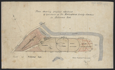
Plan, John S. Jenkins, Plan showing proposed adjustment of boundaries of the Horticultural Society's Gardens in Richmond Park, c.1880-1884
... , new hall, old garden, recent extension and proposed further..., new hall, old garden, recent extension and proposed further ...Plan on linen fibre cloth. Shows layout of Burnley bound by Swan St., Yarra River and part of Richmond Park, coloured areas showing proposed area to be added to Park, the old road, shrubbery, new hall, old garden, recent extension and proposed further extension (crossed out in red ink). Scale 4 chains:1 inch. Probably drawn by John S. Jenkins, Town Surveyor, Richmond. Has been photographed so that additional copies can be made. On a CD plus 3 negatives, plus small coloured print. (Also copy glazed and framed for Centenary Exhibition - B92.0540.)john s. jenkins, gardens, richmond, hoticultural society of victoria -
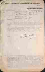
Ballarat Tramway Museum
Document - Report, State Electricity Commission of Victoria (SECV), "Electricity Supply Department - Geelong Tramways Review 1953", 1953
... By-Laws (Buses), proposed extension of the tramway routes... By-Laws (Buses), proposed extension of the tramway routes ...Demonstrates a document prepared by the SEC promoting the closure of the Geelong system. Yields historical notes and statistics on the Geelong Tramway system - very detailed information about tram use, services, staffing and routes and the costs of continuing the system in use.Sixteen page carbon copy foolscap document titled "Electricity Supply Department - Geelong Tramways Review 1953". Headings are: Early History, Creation of the SEC, Acquirement by the SEC, Agreements with Municipalities, SEC Act, Municipal By-Laws (Buses), proposed extension of the tramway routes, physical characteristics and changes at Geelong, Outlook of SEC as to tramways, Attempts to define transport future, review by the Geelong Tramway Operation by the SEC, tramcars, fares, staff and employees, trams used in normal traffic, daily mileage, average speed of services, service summary, passenger density, present outlook, prospective cost to be faced if existing system is continued, Possible improvements to the present system, extensions to the present tramway system, conclusions. Probably prepared as one of the reports to be considered by Government in its decision to close the Geelong system in 1956. Parts of text have been used in Reg Item 3478 - Geelong history and statistics. Very good reference document.'BTPS 403" in top right hand corner.trams, tramways, geelong, sec, mesco, history -
 Kew Historical Society Inc
Plan - Subdivision Plan, Camberwell Mountain View Estate, 1923
... point was the proposed extension of the Burke Road tram beyond... point was the proposed extension of the Burke Road tram beyond ...The Kew Historical Society collection includes almost 100 subdivision plans pertaining to suburbs of the City of Melbourne. Most of these are of Kew, Kew East or Studley Park, although a smaller number are plans of Camberwell, Deepdene, Balwyn and Hawthorn. It is believed that the majority of the plans were gifted to the Society by persons connected with the real estate firm - J. R. Mathers and McMillan, 136 Cotham Road, Kew. The Plans in the collection are rarely in pristine form, being working plans on which the agent would write notes and record lots sold and the prices of these. The subdivision plans are historically significant examples of the growth of urban Melbourne from the beginning of the 20th Century up until the 1980s. A number of the plans are double-sided and often include a photograph on the reverse. A number of the latter are by noted photographers such as J.E. Barnes.The so-called Camberwell Mountain View Estate was a subdivision on ‘the corner [of] Burke Road, Eyre and Wills Streets, Deepdene’. The Estate was not the first attempt to subdivide this land holding. In 1884, 1888 and 1894 the Belmore Park subdivision proposed 18 allotments for this parcel of land. The final stages of the Belmore Park subdivision occurred during the Depression of the 1890s. Apart from perhaps one block facing Burke Road, which is unnumbered in the Mountain View Estate subdivision, the rest must have remained unsold. The later subdivision would redraw the original 18 allotments, creating 22 new lots. In the Locality Plan on the left side of the subdivision plan, Deepdene Station, which formed part of the Outer Circle Railway is represented, as is the location of Deepdene Primary School. A selling point was the proposed extension of the Burke Road tram beyond its terminus at Cotham Road. The extension did not eventuate.subdivision plans - camberwell, mountain view estate -
 University of Melbourne, Burnley Campus Archives
Plan, Burnley Layout: Security Fencing, 1948-1949
... Copy of plan by L.H.B. of proposed new buildings.... of proposed new buildings, extensions and other works. Exisiting ...Copy of plan by L.H.B. of proposed new buildings, extensions and other works. Exisiting permanent buildings and those due for demolition. Second plan with sketch over showing proposed area for plant breeding, pasture, nursery, new fencing. Indication of building damaged by fire 19.12.1949.burnley school of horticulture, extensions, buildings, demolition, nursery -
 Melbourne Tram Museum
Drawing, VR Sandringham Tram Depot, 1921
... - Sandringham car shed proposed extension – with note “Not carried out... - Sandringham car shed proposed extension – with note “Not carried out ...Set of 8 drawings, prints from original VR drawings of the Victorian Railways Sandringham Railway station, tram depot, bus depot and alterations between 1921 and 1958.\ .1 - VR Sandringham to Black Rock, Electric Street Railway – Car shed at Sandringham – Locality Plan – shows car depot layout, substation, track location for both the railway and tramway, including the platform, goods shed and coal stage. Not dated. Consists of two sheets of paper joined in the middle – 420H x 1210W. Minor creases at end of rolled sheet. .2 - Drawing 1907.21 - Sandringham car shed proposed extension – with note “Not carried out” – dated 2-8-21 Second copy has stamp – Drawer 2, Folio 1, plan 2 in bottom left hand corner. 480H x 630W .3 - Sandringham Station – station layout showing proposed extension to passenger platforms for both 7 and 10 car trains, buildings shops as the southern end of the yard, rail and tramway tracks, streets, dated 12.2.1923. Drawing 582.22. 420H x 590W. .4 - Locker Room for Bus Drivers – plan 264-46, dated 2-5-1946, 295H x 420W. .5 - Shower for Bus Drivers, Plan No. 815-50, dated 15/12/1950, 295H x 420W. Has a note on the drawing – “not carried out”. .6 - Tramcar shed – Site Plan – Entrance Gates – shows conversion arrangements of the depot from trams to buses, including entrance way gates. Plan 456-56. 295H x 420W. .7 - Conversion of sub-station into New Amenities Block - plan number 51-57, dated 22.2.1957 - Detail architectural drawings for the above work. 295H x 420W .8 - Conversion of sub-station into New Amenities Block - plan number 51-57, dated 22.2.1957 - Detail architectural drawings for the above work. 295H x 420W. .9 - Proposed Improvements to Bus Depot - Plan No. 455-52 - not dated. 420H x 595Wtrams, tramways, vr, sandringham, tramways, buses, railways, black rock -
Melbourne Tram Museum
Newspaper, The Age, “Free tram expansion attacked”, 6/06/2019 12:00:00 AM
... overcrowding and loss of revenue. MP Rod Barton has proposed... overcrowding and loss of revenue. MP Rod Barton has proposed ...Newspaper clippings titled: “Free tram expansion attacked” Newspaper clipping from the Age 6/6/2019 by Benjamin Preiss Melbourne's free tram zone should not be extended according to Public Transport Users Association's Daniel Bowen. He claims it causes overcrowding and loss of revenue. MP Rod Barton has proposed the extension to cover the zoo, Shrine of Remembrance and the MCG, which has been passed in parliament. Proposal will now be examined along with cheaper off-peak fares.trams, tramways, public transport, free tram, ptua -
 Ballarat Tramway Museum
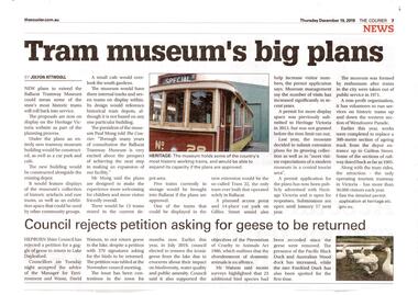
Newspaper, The Courier Ballarat, "Tram Museum's big plans", Dec. 2019
... Set of 7 items related to the proposed extension... related to the proposed extension of the BTM's depot to the south ...Set of 7 items related to the proposed extension of the BTM's depot to the south, Dec. 2019. Comprises: .1 - Newspaper clipping from The Courier, 19/12/2019 titled "Tram Museum's big plans", advising that the proposal was being advertised by Heritage Victoria, along with a photo of No. 26. .2 - Newspaper clipping from The Courier, 18/12/2019 for the advertising the permit application under the Heritage Act 2017 - in the Public Notice section. .3 - Digital image of "Museum Extension - Heritage Impact Statement - revised Oct. 2019." - 16 A4 pages. .4 - Digital image of Plans - 8 sheets of the proposal by MKM constructions. .5 - Digital image of Report - Urber Arbor - Arboricultural Report - Tree Management Plan. .6 - Digital image of Coloured site plan and drawings showing proposal depot trackwork and support mechanism around trees. Note this does not open on dbTextWorks interface. .7 - Digital image of 11 sheets of concept plans for the exterior and interior of the museum proposal by MKM Constructions. .8 - digital image of the advertising sign on the rear wall of the depot taken 7-1-2019. A similar poster was on the south east corner of the depot.btm, museum, drawings, depot extensions, heritage buildings, heritage, trackwork -
 Federation University Historical Collection
Book - Minute Book, Eureka Stockade Memorial Park Committee Minute Book
... of proposed gardens, extension of the hall .3) Swimming pool... Fund, plan of proposed gardens, extension of the hall .3 ...From the earliest minute book (1918) the committee of this organisation included women in decision making positions.Nine red hard covered books with the handwritten and computer generated minutes Eureka Stockade Memorial Park Committee . .1) Includes duties of officers, events, fundraising, payments, placing a tablet on the monument, list of members of the committee (139 names) .2) Eureka Widows and Orphans Fund, plan of proposed gardens, extension of the hall .3) Swimming pool improvement, proposed tramway extenson, electric light .7) Glasshouse .8) planting of trees .9) Eureka Stockade Centre .10) Financial Statements 11/2000-8/2003 Note, the minutes form 02/1932 to 1/1943 are not held within this collection, and were deemed to be missing when donated. gordon, eureka stockade, ballarat fine art gallery, lake penhalluriack, eureka caravan park, eureka hall, frank williams, eureka walk, dale kelly, john barnes, eureka s children, old colonists club, peter nicholson, paul wiliams, taite, ken clements, darren gamston, eureka playground, roly mckenzie, janet dore, len fox, pikeman s dog, f nielson, thomas keneally, al grasby, s jones, brian harvey, t bibby, eureka centre, eureka stockade centre, eureka stockade park committee, eureka stockade committee, e.g. pearce, bernardi, ratford, mckay, carey, mcgregor, ham, fallow, feary, jones, j.r. hams, j. davey, w. wye, r. quick, d. bernardi, eddy, gingell, micklejohn, w. mckay, w. carey, r. mcgregor, c. davies, sports programm, eureka stockade anniversary celebration, s. barker, d.c. mcgrath, m. baird, annual carnival, r. britnall, w. elsworth, g. williams, f. britnell, eurkea stockade improvement and progress association, w.j. corbett, crago, a. harrison, b. groves, s. leonard, h. parsons, e. plumridge, j. dynan, e.parsens, w.k. hood, walter a. shaw, f. pearce, a. pearce, vic carey, william carey, de gaafe, j.h. stanley, j. andrewartha, w. marshall, v.c. jones, m. byrne, caravan park, anan day, helen mckay, a. jones, n. jones, w. bromley, j. lamb, w. strange, p. hetherington, alex barnett\k. catios, l. eva, j. collins, j. shannon\, g. calions, l. o'brien, j.a. cook, w.g. fleet, g. lee, d. crooke, s. mckenzie, r. chittock, g. drake, s. romeo, p. williams, g. taite, j. webb, g. mckenzie, j. berriman, f. kennan, d. miller, d. scanlon, eureka luncheon, t. bibby, f. nielan, eureka dioramo -
 Melton City Libraries
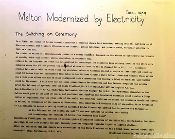
Newspaper, Melton Modernised by Electricity, 1939
... towards proposed extension a result of MSC in convincing a public... for extension of the Electric Supply to Melton is being undertaken ...Electricity – 1939 eeb Express Dec 9th 1937 Electric Light Petition First combined (schools) sports meeting, Melton south, Rockbank, Mt Cotterell, Toolern Vale, Sydenham West, Melton Park, Exford. Jack Wallace Starter, G Wilson (ref) G McDonald, F Ryan judges. A G Macdonald Gate Keeper, A Bamford, E W Barrie, S Rogers Announcers. M P A call meeting for 24th March Two or three progressive residence of Melton township are still pushing quietly for a water scheme for Melton and extension of electricity service expected to be provided for the beam wireless station a Rockbank. One of these has gone so far as to seek opinion of an independent engineer regarding the possibility of township water supply. May 1 1937 A move to combine in Melton Shire Council to convene a public meeting to agitiate for extension of the Electric Supply to Melton is being undertaken by the Progress Association and the Hall Committee. Melton Progress Association and Melton Mechanics Institute Committee joined in a decision to request Melton Shire Council to call a Public Meeting to push for extension of Yallourn electricity to Rockbank and Melton June 12th July 3rd Residents of Melton and Rockbank have an opportunity to reveal attitude towards proposed extension a result of MSC in convincing a public meeting MMI support from Amalgamated Wireless A/Asia Ltd directors Mr Townsing to preside which had been convened by MPAssoc and MMI nicely timed as SEC estimates for ensuing year known to be in course of preperation. Saturday 17th July 1937 Melton Move for Electricity. Meeting shows ….. extensive article …. meetin appointed Messrs Butler and Barrie canvass the town Dec 9th 1939 Mechanics Institute floor to be prepared next week Electricity installed in Melton, article featured in the Melton Expresslocal significant events -
 Melbourne Tram Museum
Document - Report, Parliamentary Public Works Committee, "Parliamentary Public Works Committee Report Plenty Road, Preston, Tramway Extension Enquiry, 1967
... Preston route to Bolderwood Parade. Map shows extension proposed... Preston route to Bolderwood Parade. Map shows extension proposed ...Report contained within a light brown card folder, containing a photocopy of report titled "Parliamentary Public Works Committee Report (including map) on The Plenty Road, Preston, Tramway Extension Enquiry - 1967". Report stapled in top right hand corner, 15 pages examining the extension of the East Preston route to Bolderwood Parade. Map shows extension proposed, bus routes, railway lines, streets - folded into 4.AETA stamp on front and inside sheet and "4E6" in ink on front cover. AETA stamp on the bottom right hand corner of the map.trams, tramways, east preston, new tramway, bolderwood parade, proposals -
 Melbourne Tram Museum
Document - Report, John Knee, "Warragul Road - Toorak Road Intersection", Jan. 1977
... Report - "proposed East Burwood Tramway Extension... Report - "proposed East Burwood Tramway Extension - Warragul Road ...Report - "proposed East Burwood Tramway Extension - Warragul Road - Toorak Road Intersection - Preliminary Appreciation intersection and shopping redevelopment - Jan. 1977". Prepared by John W Knee for the MMTB and others. Looks at the intersection, how the shopping centre could be accessed, possible Mall development, residential issues, passenger facilities and pedestrian capacity. Includes a number of possible access routes for the area. None were applied when the tram line was extended.Yields information about a consideration for the extension of the Toorak Road line to East Burwood in 1977.Comb bound report with clear plastic covers, brown covers, 17 A4 pagesmmtb, east burwood, toorak road, warragul road, new tramways, john knee -
 Melton City Libraries
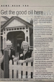
Newspaper, Get the good oil here…, 2001
... the National Trust objected that the proposed extension would... the National Trust objected that the proposed extension would ..."A court was established in Melton by 1864, when the first recorded case was heard before Mr BA Porter JP, with Mr A Carroll as the Clerk of Courts. John James was convicted of being drunk, for which he was fined five shillings or 24 hours imprisonment. The court was held in the ‘long room’ of the old Melton Hotel, before moving to rented accommodation at the Raglan Hotel, and finally to the Roads Board office. Tenders for construction of the present building were called for by the Public Works Department on 13th February 1892. The architect Samuel Edward Brindley was born in Birmingham, England, in 1842. He was articled to the local architect, J.R. Botham, FRIBA, before emigrating to Victoria where he was employed as an architect in the Education Department from 18 August 1873. With the amalgamation of the architectural branch of the Education Department with the Public Works Department in 1884, Bindley was placed in charge of Victorian government building design for the North-Western District. In 1975, the Melton and District Historical Society became concerned at hearsay that the court house was to be demolished to make way for carparking space. Melton had been declared a ‘satellite city’ and was developing rapidly. A new shopping centre had recently been built at a setback of 60 feet (c.18 metre) from 323-329 High Street, and the court house, together with the adjacent weatherboard police station, had been left standing alone. A new police station was planned, and the weatherboard police station was subsequently demolished. In its nomination of the building for National Trust classification the Society argued that the Court House was ‘the best of two early buildings left in the main street’ (the other being a bluestone hotel) and that its loss would be ‘tragic’. However the nomination was unsuccessful, the National Trust at the time judging that it was of no particular ‘distinction’ or ‘antiquity’. The building continued to be used as a court house at least until 1991 when the Department of Housing and Construction (formerly the PWD) conducted a heritage study of court houses. By this time Federation-era architecture had achieved acceptance within the heritage movement. The building was recognised as being ‘the only surviving example in brick of the Federation Queen Anne style which was used for court houses only twice.’ Twenty years later when it was proposed to modify the eastern façade of the building to accommodate a café, the M&DHS was again concerned. This time the National Trust objected that the proposed extension would be an over-development of the site, and questioned the changes to the interior court room furnishings and fittings. The site never appears to have been nominated to the Victorian Heritage Register. It has since been converted into the Shire of Melton Tourist Information Centre". Opening of the Visitor Centre in Meltoncouncil, local architecture -
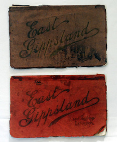 Orbost & District Historical Society
magazines, Atlas Press Pty Ltd, East Gippsland & Railway Extension, 10 September 1908
... Orbost and East Gippsland Railway League had proposed... gippsland Orbost and East Gippsland Railway League had proposed ...Orbost and East Gippsland Railway League had proposed a railway extension through East Gippsland in 1908, which aimed to develop an isolated part of the country. At the time, construction of a railway could be considered a beneficial investment for the country as it could increase the population in the region. The proposed railway length in 1908 was about 140 miles and the cost was estimated £800,000. The line was proposed to proceed from Bairnsdale by way of the Lower Nicholson to Bruthen. “After crossing the Tambo River, it would be carried to near Nowa Nowa; the head of Lake Tyers, forward to Orbost. From Orbost it would proceed in a north-easterly way to the New South Wales border. There were different suggested routes between Orbost and the New South Wales border, the first was through Bendoc, another by the Cann River and another which is located between these two. This item is associated with the history of the Orbost-Bairnsdale railway line and therefore reflects the role that the rail line played in the social and economic history of Orbost. The Bairnsdale-Orbost railway was opened in 1916 to serve the agricultural and timber industry. Because of the decline in traffic and heavy operating costs, the line was finally closed in August, 1987. Two small magazines showing the railway extension through East Gippsland. 678.1 has a dark maroon cover with gold print writing. It contains b/w photographs. 678.2 has a red cover with black print writing. Both are bound. 678.1 - inside front cover - M. Beattie ???????? Newmerella 678.2 - inside front cover - Gordon Fisher Orbosteast-gippsland-railway-league railway -
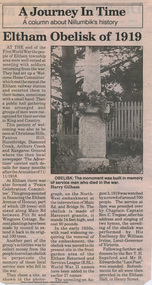 Eltham District Historical Society Inc
Folder, Eltham Obelisk (later Cenotaph), 1918-2018
... and Stakeholders Meeting, Proposed Extension to Memorial Terrace, 11... and Stakeholders Meeting, Proposed Extension to Memorial Terrace, 11 ...The Eltham Obelisk was originally located at the corner of Bridge and Main Roads in 1919. In 1943 (WW2) the local community commenced plans to establish the Eltham War Memorial, a living memorial to benefit the children as opposed to a one in stone as per the obelisk. The Eltham War Memorial Trust was established in 1945. In 1947 the Trust intended for the Obelisk to be relocated from Bridge Street and Main Road to the Garden of Remembrance which was planned as part of the Baby Health Centre which was to be the first of three buildings of the Eltham War Memorial to be built in 1951. In 1951 the Eltham RSL was invited to be represented on the Eltham War Memorial Trust. Around this time, with pending roadworks, the obelisk was relocated to the front garden of the Eltham RSL sub branch on Main Road for safe keeping. In 2007, a suggestion was proposed by Harry Gilham (President, EDHS) to John Cohen (ERSL) to claim a special site along with the historic Shillinglaw trees on the now vacant former Eltham Shire Office site adjacent to the Eltham War Memorial precinct for relocation of the obelisk. In 2010 following the financial collapse and sale of the Eltham RSL Sub-Branch property and amalgamation with the Montmorency Eltham RSL sub-branch, the location of the obelisk was again in immediate jepoardy and in conjunction with Nillumbik Shire Council, the obelisk was relocated in front of the Eltham War Memorial buildings in preparation for the Dawn Service on Anzac Day 2012. Contents: Newspaper article: Eltham Obelisk of 1919, Harry Gilham, August 2000 as well as draft submitted dated 22 Aug 2000 Newspaper article: Eltham, The Advertiser 15 Nov 1918 and 18 Nov 1918 Newspaper article: An Obelisk at Eltham, The Advertiser, 11 Jul 1919 Newspaper advertisement: Unveiling of Obelisk at Eltham, The Advertiser, 1 Aug 1919 Newspaper article: Eltham Soldiers’ Memorial; Unveiled by Sir William Irvine, The Argus, Monday, 4 Aug 1919, p8 Newspaper article: Eltham Memorial to Fallen Soldiers, Diamond Creek Valley Advocate, 8 Aug 1919 Newspaper article: Memorial to the Fallen; Unveiled at Eltham, The Age, Monday, 4th August 1919 Newspaper article: Programme - Presentation of German Machine Gun at the Obelisk, Eltham on Sunday, 8th August, 1920, at 3.30 P.M. Newspaper article: article about presentation of a war trophy, a heavy machine gun placed beside obelisk, The Advertiser, 13 Aug 1920 Newspaper article: Eltham: ANZAC Services, The Advertiser, Friday, May 2, 1924 Newspaper article: Eltham War Memorial, The Advertiser, Oct 26, 1928 Handwritten note from Harry Gilham (President EDHS) to John Cohen (ERSL) regarding history of Eltham RSL site and 1947 newspaper article "Eltham War Memorial Trust "Garden of Remembrance" referencing relocation of Obelisk to the proposed Garden of Remembrance at the Baby Health Centre (Eltham War Memorial). Officers' reports, 11.113/10 Relocation of Eltham RSL Cenotaph, Nillumbik Shire Council Ordinary Meeting, 21 December 2010 Email Correspondence: EDHS President to NSC General Manager Community and Leisure re RSL Obelisk (Cenotaph) proposed relocation, 24 May 2011 Newsletter Extract: Eltham RSL and War Memorial, EDHS Newsletter 14 Sep 2011 Officers' reports, OCM.091/11 Interim Relocation site for the Eltham Cenotaph, Nillumbik Shire Council Ordinary Meeting, 23 August 2011 Officers' reports, OCM.004/121 Interim Relocation of the Eltham Cenotaph, Nillumbik Shire Council Ordinary Meeting, 31 January 2012 (includes Funding agreement between NSC and Montmorency-Eltham RSL Sub-branch Inc) Newspaper article: Move war memorial: RSL, c.2011 Newspaper article: Memorial move lags, Diamond Valley Leader, 1 February 2012 Newspaper article: New dawn for tribute, Diamond Valley Leader ca April 2012 Open letter to the residents of Eltham and Montmorency and copies of drafts by the Montmorency Eltham RSL, no date and final version published in Diamond Valley New 21 March 2012 and Banyule & Nillumbik Weekly, 27 March, 2012 Newspaper article: RSL site nets $1.8m, Diamond Valley Leader, 9 May 2012 Newspaper article: Memorial Moved, Banyule/Nillumbik Weekly, 10 April 2012 Newspaper article: Eltham cenotaph move goes 'like clockwork', Diamond Valley Leader, 11 April 2012 Advertisement, Program for Eltham Dawn Service, Diamond Valley Leader, April 2012 Newspaper photo: Veterans (l-r) Alan Field, Max Lowerson and John Cohen will join piper David Cretney to commemorate fallen Diggers, 2012 (standing beside relocated obelisk in front of the Eltham War Memorial complex) Program for Montmorency Anzac Day March 2012 (incomplete, some pages duplicated, some pages upside down). Newspaper article: Plan to expand memorial, Diamond Valley Leader, Sep. 2004, p5 Newspaper article: Names renewal, thanks to Barry, Diamond Valley Leader, 18 Apr 2007, p3 with picture featuring Eltham RSL president John Haines and Gwen Rosewall Letter: EDHS President to Manager Community Participation, Learning and Culture, Nillumbik Shire Council regarding a proposal by the Montmorency-Eltham RSL Sub-branch to expand the area occupied by the relocated obelisk further into the Eltham War Memorial Garden of Remembrance, 18 Aug 2014 Notices of Motion, NOM.001/14 pertaining to memorials Advisory Committee and Montmorency-Eltham RSL to upgrade the Eltham War Memorial site in time for ANZAC Day 2015, Nillumbik Shire Council Ordinary Meeting, 26 August 2014 Agenda: User Groups and Stakeholders Meeting, Proposed Extension to Memorial Terrace, 11 September 2014 EDHS presentation to NSC Policy and Services meeting 9 September 2014 regarding the Montmorency-Eltham RSL proposal to expand/upgrade the Eltham War Memorial Policy and Services reports, PSD.034/14 Eltham War Memorial Building Precinct - Proposed Extension to Memorial Terrace, Nillumbik Shire Council Ordinary Meeting, 9 September 2014 Email (copy): President EDHS re Eltham War Memorial Complex, Main Road, Eltham, 15 Sep 2014 requesting Nillumbik Shire Council place a Heritage Overlay upon the Eltham War Memorial Complex Media Release: Support for cenotaph expansion, Nillumbik Shire Council, Sep 2014 Newspaper article: Council defers RSL war memorial upgrade to see consultation, Diamond Valley News, 17 Sep 2014 Letter (copy): Harry Gilham, Eltham to local press and others, 20 Sep 2014 protesting attempts by the RSL to further expand upon the area already ceded from the Eltham War Memorial for the relocated WW1 obelisk and alter the original vision for an Eltham War Memorial complex. Letter: Alan Field, President, The Eltham Veterans War Memorial Preservation Society Inc. to CEO and Councillors, Nillumbik Shire Council protesting at perceived injustices and ‘veteran bashing’ regarding their previous efforts to relocate ‘their Obelisk and Cenotaph’ to the Eltham War Memorial complex and their frustration in their attempts to further expand upon the Memorial Terrace. Areas of letter are highlighted with handwritten markups and notes. Also notes on loose card and paper with definitions of Memorial, Obelisk, Cenotaph, commentary on establishment of Eltham War Memorial, The Eltham War Memorial Trust and RSL involvement and current actions by RSL in respect to claims in the letter (written by Harry Gilham ?). Policy and Services reports, PS.038/14 Eltham War Memorial Building Precinct - proposed extension to the Eltham Cenotaph Terrace, Nillumbik Shire Council Policy and Services Committee Meeting, 14 October 2014 Newspaper article: Centenary dawn service moves to Petrie Park, Diamond Valley Leader, 22 Oct 2014 Newspaper article: Upset over upgrade; war memorial revamp plans get culled, Diamond Valley Leader, 29 Oct 2014 Newspaper article: Memories of our heroes, Diamond Valley Leader, 25 Apr 2018 – also Veteran saluted, featuring article on Army veteran, Glen Ferrarotto. Handwritten notes in pencil (2 pages) by Harry Gilham, Items form the Eltham and Whittlesea Shires The Advertiser newspaper 7 June 1918 - 1919 providing a summary of the formation of the Peace Celebration Committee leading to the establishment of the Avenue of Honour and the Eltham Obelisk Newspaper article: Obelisk honors their memory, Diamond Valley News, March 30, 1971, p11eltham cenotaph, nillumbik shire council, eltham war memorial, montmorency eltham rsl sub-branch, dawn service, cenotaph, eltham rsl sub-branch, eltham war memorial trust, garden of remembrance, harry gilham collection, john cohen, obelisk, remembrance garden, shillinglaw trees, german machine gun, war memorial, war trophy -
 Ringwood and District Historical Society
Plan - Proposed Ringwood East Railway Station, VR Ringwood-Croydon (Dublin Road) - 1923
Technical drawing of "Proposed Station At 16Mls 38Chs 89Lks (Dublin Road)" inluding boundary line, red shaded platform with station buildings, and green shaded possible future "up" track. Surrounding streets include Dublin Road, Patterson Street, and subsequent hand-written additions of Railway Avenue, Lawrence Grove, Stanley Avenue, Wenwood Street, and Lois Street. Land title details of Patterson Street properties mainly illegible.Scale: 40'=1". Possible future (platform) extension for 8 car trains (and) extension for 10 car trains. -
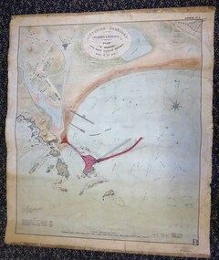 Warrnambool and District Historical Society Inc.
Map - Warrnambool Port 1879, 1879
The port facilities in Warrnambool Bay were in constant use from the first years of Warrnambool’s settlement but there were also difficulties for the shipping trade – a small and unsafe anchorage, the lack of loading facilities and little natural protection from the southerly gales. From the 1870s on there was local agitation for some sort of Breakwater to be built and an Andrew Kerr design was approved by the Warrnambool Council but no funds were made available from the Victorian Government. Throughout the 1870s the building of a Breakwater was a major political issue in the district with preliminary work being funded and started in 1874. In 1879 the Government agreed to a further inspection of the area and an official report. Sir John Coode (1816-1892) was commissioned to make this report. He had come to Australia in 1872 to advise on harbour construction. Coode recommended a 1800 feet long Breakwater and wharf connected to the shore and it was this proposal that the plan described herein and drawn up in 1879 was to accompany. The original plan was eventually modified because of the cost and a Breakwater was completed in 1890 under the direction of the engineer, Arthur Dudley Dobson, with extensions early in the 20th century. This plan is of great interest as it shows in simple graphic form the original plans proposed by Sir John Coode for the Warrnambool Breakwater. It is therefore of great historical importance. The Breakwater was not the maritime success that it was hoped it would be but it is today a significant feature of our foreshore. This is a Plan drawn up in 1879 by Victorian Harbours to accompany Sir John Coode’s Report on the proposed Warrnambool Breakwater. The chart detail is hand-drawn and hand-tinted on canvas with the names of places, geographical and marine features and local points of interest added in print. The edges of the chart are rubbed and the chart is somewhat faded and dirty but the main colours of red, green and brown are still clearly discernible. The title of the plan is printed in an oval inset at the top of the chart. The plan shows two possible Breakwater designs, one from the Borough Surveyor (Andrew Kerr?) and one from Sir John Coode.Victorian Harbours Warrnambool Plan to accompany Sir John Coode’s report Dated 28th Feby 1879 warrnambool breakwater, andrew kerr, sir john coode, arthur dudley dobson, warrnambool, warrnambool harbour, warrnambool history, warrnambool beach -
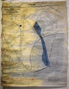 Warrnambool and District Historical Society Inc.
Map - Map of Proposed Alterations to Warrnambool Harbour 1925, Warrnambool Harbour Committee, Warrnambool Harbour Proposed Wharves and Basin in Lake Pertobe with Eastern Wall, 1925
This map was printed in 1925 and contains the Warrnambool Harbour alterations proposed by the Warrnambool Harbour Committee incorporating the original designs of Captain Menzies, the Warrnambool Harbour Master and the City Engineer, Mr A. Lavercombe. The main features of the proposal were the extension of the Eastern Wall to almost enclose the harbour and a basin in Lake Pertobe. The design was to be placed before the Victorian Royal Commission on the Outer Ports which was established partly to examine the allegations of unsatisfactory work carried out in Warrnambool when the Breakwater was extended 300 feet in 1914 and also to make recommendations regarding all regional ports. The Warrnambool Breakwater was completed in 1890 but failed to provide the shipping conditions needed to continue Warrnambool as a viable port. Many plans and proposals for port improvement such as this one were produced in the late 19th century and the first half of the 20th century with the port officially closed in the 1940s. Still today the Breakwater and Warrnambool Harbour conditions remain a source of contention.This map is significant as it shows a 1925 design for Warrnambool Harbour hitherto little-known. It also has markings showing land sites of the time (BayView Hotel, Woollen Mill etc.)This is a map made of thick yellow paper pasted onto a cloth backing. It has two cloth tags at the top for tying up the map when folded. It appears to be a hand-drawn map copied with printed material added. The map is shaded green and red in some areas. Attached by nails to the map are wooden frames, rounded at the bottom and partly curved at the top. The map is torn and partly detached at the top. The top frame has a cord attached for hanging the map.warrnambool harbour, captain menzies, a.lavercombe city engineer, warrnambool breakwater, royal commission on outer ports -
 Eltham District Historical Society Inc
Photograph, The first houses in construction on the new Stokes Orchard Estate, July 1976, July 1976
Viewed from near the Stokes family home at 1 Nyora Road looking northeast across Ironbark Close to Scarlet Ash Court with Peppermint Grove in the distance. Frank Stokes first traveled to the district by train in 1944 to find land with the intention to establish an orchard. By chance he met Arthur Bird of Bird Orchard (bounded by Pitt Street, Eucalyptus Road and Wattle Grove) and they got talking over their common interest. Arthur put Frank up for the night and pointed out the land, part of Crown Allotment 15, Section 5, Parish of Nillumbik (CA15) somewhat diagonally opposite Bird Orchard. Frank bought the land and for the next two years would travel by train from Melbourne to Eltham every weekend establishing Stokes Orchard and building a home for his family, which they eventually moved into in 1946. In the mid 1970s the Shire of Eltham divided the orchard up into numerous rate-able parcel lots, which became affordable for Frank. As a consequence Stokes Orchard was turned into a housing development by Macquarie Builders and marketed as the Stokes Orchard Estate in two stages; Stage 1 encompassing Scarlet Ash Court, Ironbark Close and Peppermint Grove bounded by Nyora and Eucalyptus roads c.1976 and Stage 2 encompassing Stokes Place, Orchard Way, The Crest and The Lookout bound by Nyora and Diosma roads c.1979. The development of Orchard Way, The Crest and The Lookout did not proceed as planned due to the lack of the sewer along Diosma Road and so many of the proposed lots were incorporated into five-acre parcels instead.Housing development in Eltham as an extension to the Woodridge EstateDigital file only - Digitised by EDHS from a scrapbook (containing commercially printed photos of digital scans) on loan from Beryl Bradbury (nee Stokes), daughter of Frank Stokes.1976-07, beryl bradbury (nee stokes) collection, building construction, ironbark close, nyora road, peppermint grove, scarlet ash court, stokes orchard estate, houses -
 Eltham District Historical Society Inc
Photograph, Looking south towards Nyora Road, Eltham, 1977, 1977
Viewed from near the end of Stokes Place where the linear reserve now runs between 8 and 9 Stokes Place just visible through trees in foreground, 24 Nyora with red roof is the first house in middle of view. Frank Stokes first traveled to the district by train in 1944 to find land with the intention to establish an orchard. By chance he met Arthur Bird of Bird Orchard (bounded by Pitt Street, Eucalyptus Road and Wattle Grove) and they got talking over their common interest. Arthur put Frank up for the night and pointed out the land, part of Crown Allotment 15, Section 5, Parish of Nillumbik (CA15) somewhat diagonally opposite Bird Orchard. Frank bought the land and for the next two years would travel by train from Melbourne to Eltham every weekend establishing Stokes Orchard and building a home for his family, which they eventually moved into in 1946. In the mid 1970s the Shire of Eltham divided the orchard up into numerous rate-able parcel lots, which became affordable for Frank. As a consequence Stokes Orchard was turned into a housing development by Macquarie Builders and marketed as the Stokes Orchard Estate in two stages; Stage 1 encompassing Scarlet Ash Court, Ironbark Close and Peppermint Grove bounded by Nyora and Eucalyptus roads c.1976 and Stage 2 encompassing Stokes Place, Orchard Way, The Crest and The Lookout bound by Nyora and Diosma roads c.1979. The development of Orchard Way, The Crest and The Lookout did not proceed as planned due to the lack of the sewer along Diosma Road and so many of the proposed lots were incorporated into five-acre parcels instead.Housing development in Eltham as an extension to the Woodridge EstateDigital file only - Digitised by EDHS from a scrapbook (containing commercially printed photos of digital scans) on loan from Beryl Bradbury (nee Stokes), daughter of Frank Stokes.1977, beryl bradbury (nee stokes) collection, nyora road, stokes orchard estate, stokes place -
 Eltham District Historical Society Inc
Photograph, Stokes Place, Eltham, July 1977, July 1977
Viewed from near the end of Stokes Place where the linear reserve now runs between 8 and 9 Stokes Place looking slightly east of south towards Nyora Road. The new Christian Church on Nyora now the Baptist Church visible in middle view. Frank Stokes first traveled to the district by train in 1944 to find land with the intention to establish an orchard. By chance he met Arthur Bird of Bird Orchard (bounded by Pitt Street, Eucalyptus Road and Wattle Grove) and they got talking over their common interest. Arthur put Frank up for the night and pointed out the land, part of Crown Allotment 15, Section 5, Parish of Nillumbik (CA15) somewhat diagonally opposite Bird Orchard. Frank bought the land and for the next two years would travel by train from Melbourne to Eltham every weekend establishing Stokes Orchard and building a home for his family, which they eventually moved into in 1946. In the mid 1970s the Shire of Eltham divided the orchard up into numerous rate-able parcel lots, which became affordable for Frank. As a consequence Stokes Orchard was turned into a housing development by Macquarie Builders and marketed as the Stokes Orchard Estate in two stages; Stage 1 encompassing Scarlet Ash Court, Ironbark Close and Peppermint Grove bounded by Nyora and Eucalyptus roads c.1976 and Stage 2 encompassing Stokes Place, Orchard Way, The Crest and The Lookout bound by Nyora and Diosma roads c.1979. The development of Orchard Way, The Crest and The Lookout did not proceed as planned due to the lack of the sewer along Diosma Road and so many of the proposed lots were incorporated into five-acre parcels instead.Housing development in Eltham as an extension to the Woodridge EstateDigital file only - Digitised by EDHS from a scrapbook (containing commercially printed photos of digital scans) on loan from Beryl Bradbury (nee Stokes), daughter of Frank Stokes.1977-07, beryl bradbury (nee stokes) collection, eltham, eltham christian church, stokes orchard estate, stokes place