Showing 72 items matching "sunbury township."
-
 Sunbury Family History and Heritage Society Inc.
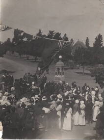
Photograph, Starkie Memorial Fountain, 26th February 1915
... of Brook, O'Shanassy and Stawell Streets in Sunbury Township... of Brook, O'Shanassy and Stawell Streets in Sunbury Township ...The photograph was taken in 1915 at the opening of the Starkie Memorial Fountain that was erected at the intersection of Brook, O'Shanassy and Stawell Streets in Sunbury Township. Joseph Starkie was instrumental in establishing a reliable water supply which was turned on 13th March 1905. The fountain was erected in recognition of his contribution to the town 10 years later on 26th February 1915. As the town grew and the main shopping strip became busier, it was relocated to a memorial site opposite the Memorial Hall.The Starkie Fountain is one of Sunbury's important memorials erected to celebrate an important development in the town.A non-digital black and white photograph of a crowd of people are gathered around a monument for a ceremony. Flags are festooned above the crowd and an open parkland is in the background as well as a church. Details of the event are handwritten on the back of the photograph.joseph starkie, j.d.starkie memorial, stawell street, sunbury, water fountain -
 Sunbury Family History and Heritage Society Inc.
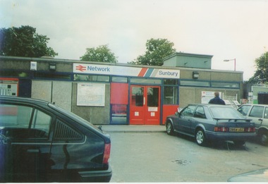
Photograph, September 1996
... was named after the English township of Sunbury-on-Thames... the English township of Sunbury-on-Thames in Middlesex by the Jackson ...The photograph shows the railway station at Sunbury in Surrey in the United Kingdom. The town of Sunbury in Victoria was named after the English township of Sunbury-on-Thames in Middlesex by the Jackson Brothers who took up land in Sunbury, Victoria. The area was originally known as Koora Kooracup by the Wurundjeri people.Sunbury in Victoria like many other settlements in Australia were given names of towns in the United KingdomA coloured photograph of a railway station with three cars parked outside the building, which has grey walls and scarlet and blue trims. There are framed maps and notices on the exterior walls. -
 Hume City Civic Collection
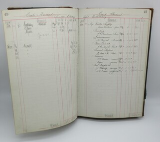
Cash Book, Cash Book Electric Lighting Shire of Bulla, 1909
... the township of Sunbury and together with the erection of a Power House... supplied the township of Sunbury and together with the erection ...The Cash Book was used by the Shire of Bulla Electric Light Department to record by hand writing costs associated with supplying electricity, employee wages and users of electricity between October 1909 and November 1926. The first two generators supplied the township of Sunbury and together with the erection of a Power House were officially opened in 1910. The State Electricity Commission took over the supply of electricity in Sunbury in 1926.Large green cloth covered hard cover with tan corners and spine. Tan and purple mottled pattern inside front and back cover."Arnall & Jackson/Engravers..."1900s, shire of bulla, sunbury, george evans collection -
 Whitehorse Historical Society Inc.
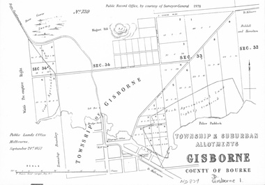
document - Map, Melbourne Metro, 1978
... , 1855; Township of Sunbury, 1857; River Yarra Yarra..., 1853; Township of Sandridge, 1855; Township of Sunbury, 1857 ...Collection of reproductions issued by the Public Record Office in 1978. Comprises: Allotments in the Black Forest, 1857; Township of Dandenong, 1856; Township and suburban allotments, Gisborne, 1857; Storing Yard allotments near the Melbourne Wharf, 1854; Town lots near the Railway Terminus, Melbourne, 1863; Parish of Prahran, 1853; Township of Sandridge, 1855; Township of Sunbury, 1857; River Yarra Yarra at the Queens Wharf, 1860.victoria. public record office, black forest, victoria, dandenong, gisborne, melbourne wharf, railway terminus, spencer street, melbourne, prahran, sandridge, sunbury, queens wharf -
 Sunbury Family History and Heritage Society Inc.
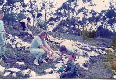
Photograph, Painting school sign, 1988
... the rocks with white paint. Anyone approaching Bulla township from... with white paint. Anyone approaching Bulla township from Sunbury ...In 1988, the senior students at Bulla Primary School, under the supervision of their teacher undertook a community activity to paint a school sign that could be seen from a distance. They collected rocks that were lying across the exposed hillside above the school and arranged them into the word 'BULLA'. They then painted the rocks with white paint. Anyone approaching Bulla township from Sunbury would see the sign across the valley. The sign remained there for the following eight years but was dismantled when the school property was sold.The painted sign on the hillside became an important signpost for people travelling into the township as it was visible even from a low flying aircraft, which were either descending to land or had just taken off from the nearby airport.A non-digital coloured photograph of four children and an adult painting rocks on a hillside.bulla primary school, school painted sign, bulla township -
 Victoria Police Museum
Police stations (Aitken's Gap)
Aitken's Gap, otherwise known as The Gap or Buttlejork, and 3km west of Sunbury, was established as a township in 1845. It is in the area which is now bordered by the Calder Highway and Gap Road. The village was named after John Aitken, a Port Phillip pastoralist who took up the Mount Aitken run in 1836. Aitken's Gap Police Barracks (in the District of Bourke) opened in 1853 and was staffed by two Mounted Constables and one Foot Constable. The gaol (used to house prisoners and also gold en route to Melbourne) was built in 1857 from bluestone quarried in the area. The roof was made of slate. In 1861 it was staffed by 1 Mounted Senior Constable and 1 Foot Constable. The Barracks closed in 1863 when the Bendigo rail line was completed and the gold was transported to Melbourne by rail. All the buildings, except the gaol, were moved to Sunbury. The land was sold in 1870 and in 1989 the current owner donated the building to the Sunbury Police. The original building was dismantled, restored and rebuilt outside Sunbury police station.15 colour photos and 1 black and white photopolice stations; aitken's gap police station -
 Hume City Civic Collection
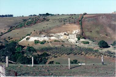
Photograph, c Early 1990's
The Kaolin quarries at Bulla were an important industry in the district and supplied clay products to the Cornwell and Hoffman companies in Brunswick. The Kaolin deposits were found in the 1850's and were considered to be some of the largest in the colony.A landscape photograph of a valley with a post and wire fence and a partial view of a farm gate in the immediate foreground. A clump of native trees are on the LHS and a small grove of almond trees has been planted on the river flat. Kaolin quarry is on the hillside and two buildings can be seen on the hill top. High tension pylons are in the distance near the skyline.kaolin quarries, almond groves, bulla township, deep creek, hoffmans kaolin mine, hoffmans potteries, cornwell potteries, george evans collection -
 Hume City Civic Collection
Photograph
The former bluestone Bulla Shire Hall building was constructed in 1867 and remained the centre of local government until the early 20th century when the administration was moved to Sunbury. In the 1990's the Alister Clark Rose Garden was established in the surrounding grounds. The garden is open to the public all the year round. In 1999 the rose garden was officially opened.A coloured photograph of the front elevation of the original Shire of Bulla offices. It is a bluestone building, double fronted with a pitched roof on both wings and above the porch. The woodwork trims have been painted in cream and red. The double wooden front door is painted red. The sign outside the building indicates the former function of the building and its importance.ORIGINAL/SHIRE OF BULLA/OFFICE/1868-1923shire of bulla, council chambers, rose gardens, rose growing, bulla township, roses, clark, alistair, george evans collection -
 Hume City Civic Collection
Photograph
The former bluestone Bulla Shire Hall building was constructed in 1867 and remained the centre of local government until the early 20th century when the administration was moved to Sunbury. In the 1990's the Alistair Clark Rose Garden was established in the surrounding grounds. The garden is open to the public all the year round. In 1999 the rose garden was officially opened.A coloured photograph of the side garden and the bluestone building which was the shire offices of the former Shire of Bulla. A treated pine fence runs along the front of the property. The roses in the garden are supported with the stakes and there is a backdrop of trees behind the building.shire of bulla, council chambers, rose gardens, rose growing, roses, bulla township, clark, alistair, george evans collection -
 Hume City Civic Collection
Photograph, c late 1980s
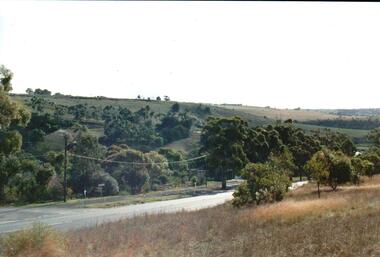
The photograph shows a section of the original settlement of the Bulla township. The cutting on the hillside is significant as it is the remains of one of the original stream crossings in Victoria.A coloured photograph of the Bulla Hill along Sunbury Road with a view of the cutting on the distant hillside. The photograph is a view of the old Bulla township looking to the NW. There is a wide grassy verge in the foreground.bulla township, deep creek, wright, william 'tulip', sunbury road, george evans collection -
 Hume City Civic Collection
Photograph, late 1990s
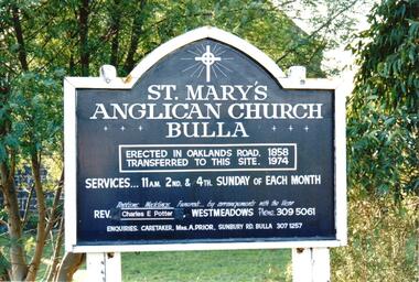
St. Mary's Anglican Church at Bulla was originally built on the outskirts of Bulla township in 1858. In the early 1970s it was moved to its present site to make way for the flight path at the newly constructed Tullamarine Airport. The former site was on the corner of Oaklands and Sunbury Roads and is covered with vegetation. The church was designed by Thomas Taylor.A coloured photograph of the board which is along the fence line outside St. Mary's Church at Bulla. The white writing is on a navy blue background and is framed in white. The notice gives details of services, clergy and caretaker.churches, religion, anglican church, taylor, thomas, potter, charles e. rev., prior, a., st. mary's anglican church, george evans collection -
 Hume City Civic Collection
Photograph, late 1990s
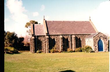
St. Mary's Anglican Church at Bulla was originally built on the outskirts of Bulla township in 1858. In the early 1970s it was moved to its present site to make way for the flight path at the newly constructed Tullamarine Airport. The former site was on the corner of Oaklands and Sunbury Roads and is covered with vegetation. The church was designed by Thomas Taylor.A profile view of the west side of St. Mary's Anglican Church at Bulla and the garden area around the church. A slate covered gable roof has been constructed over the porch nave and chancery with a cross at each end of the roof over the nave. 6 bluestone buttresses and 3 lance windows are along the side with 3 small lancet windows and a blue painted wooden lancet door on the porch.churches, religion, taylor, thomas, st. mary's anglican church, george evans collection -
 Hume City Civic Collection
Photograph, c1930s
St Mary's Anglican Church was originally built on land in Oaklands Road. It was licensed in 1859 by Bishop Perry, the first Anglican bishop of Melbourne. In the late 1960s the church was dismantled and rebuilt on its present site at Bulla, adjacent to the former Council Chambers. it was shifted to the township of Bulla because the building was under the direct path of a proposed future flightpath.vintage cars, churches, st. mary's anglican church - bulla, george evans collection -
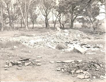 Hume City Civic Collection
Photograph, late 1960s
In the late 1960s St. Mary's Anglican Church was dismantled from its Oaklands Road site and rebuilt on land in Bulla township adjacent to the old shire offices. It was moved because of the interference it would create for aircraft landing in the new Melbourne Airport at Tullamarine. The site has been left timbered because some of the district's early settlers were buried in the church yard before the Bulla Cemetery was established.A black and white photograph of the site of the former St. Mary's Anglican Church at Oaklands Road. There are heaps of building rubble in the foreground and trees in the background.st. mary's anglican church - bulla, oaklands road, graveyards, george evans collection -
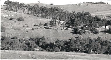 Hume City Civic Collection
Photograph, 1980s
This photograph was taken from the intersection of Loemans and Sunbury Roads. It overlooks the site of the former Bula Primary School and the hillside where stones were laid and painted to form the words "Bulla". The lettering was possible a project carried out by the pupils at the school.A black and white photograph of a panoramic view overlooking the former Bulla Primary School. The photograph has been taken from the intersection of Loemans and Sunbury Roads.bulla primary school, bulla township, george evans collection -
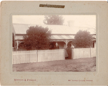 Hume City Civic Collection
Photograph, c1907
Members of the Fanning family standing outside their house 'Sunnyside', in Loemans Road, Bulla. The Fannings were one of the early European families to settle in the Bulla township. A black and white mounted photograph of the Fanning family in front of a cottage with a picket fence.Printed on face: Matson and Frazer / 264 Little Collins Street Handwritten on back: Eric Boardmanmatson and frazer, photographers, eric boardman collection, fanning family, george evans collection -
 Hume City Civic Collection
Photograph, Early 1970s
The Kaolin Quarry at Bulla supplied Kaolin to the Northcote and Brunswick Pottery Works until it ceased operation at that site in the 1950s. The three arched bluestone bridge r3placed a ford crossing across Deep Creek, which along with Jacksons Creek flows into the Maribyrnong River.A black and white photograph of the Deep Creek and three arched bluestone bridge in the Bulla Township with the Kaolin Quarry in the background. One truck is crossing the bridge with a tanker approaching the bridge at the bottom of the Bulla Hill.deep creek, bridges, kaolin quarries, quarries, george evans collection -
 Hume City Civic Collection
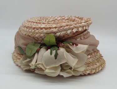
Lady's pink straw hat, 1960's
The hat belonged to Edna Vlassopoulos who with her husband Andrew, had a poultry farm and market garden in the old Westmeadows township and later at Bulla. The hat was purchased to wear at a family wedding.A pink straw hat with a pink silk folded band wrapped above a narrow brim. There is a full-blown pink silk rose which is a trim on the RHS of the crown. There is a band of petersham ribbon inside the crown with black hat elastic fastened on either side.clothing and dress, headwear, female, george evans collection -
 Hume City Civic Collection
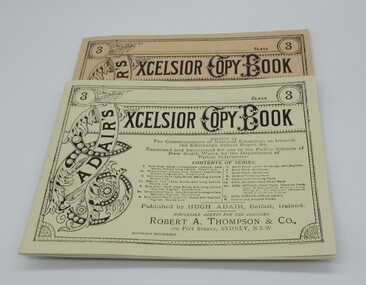
Book, Adair's Excelsoir Copy Book
This is a facsimile reproduction published by the Ballarat Historical Park Association, Sovereign Hill Goldmining Township, Ballarat, Victoria 3350, for the use in the Red Hill National School, Sovereign Hill.A cream coloured book with black lettering on the cover. Pages ruled out for copying handwriting.adair, hugh, schools, teaching, nsw department of public education, sovereign hill gold mining township., george evans collection -
 Hume City Civic Collection
Book, Elementary Drawing Copy Book
This is a facsimile of a drawing copy book compiled by an art teacher in london in 1864 and copied by the Ballarat Times, Sovereign Hill Goldmining Township for use at the Red Hill National School.A tan coloured cover with pages set out to enable students to copy different drawings printed at the top of the pages.teaching, primary school, sovereign hill goldmining township, george evans collection -
 Hume City Civic Collection
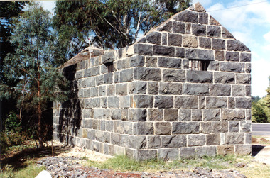
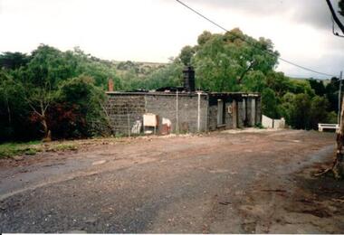
Phortograph, 1989
The building is the former Bulla Post Office and general store which was damaged by fire in 1989 and never rebuilt. A private house now occupies the site. The post office was relocated to a service station about 1km away. For many years the former Bulla Post Office and store was the focal point in the small township.A coloured photograph of a bluestone building by a roadside which has been gutted by fire. There is no roof but the chimney is intact. -
 Hume City Civic Collection
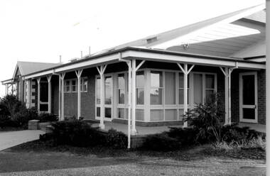
Photograph, Bulla Community Centre, c1980s
The building is the Bulla Community Centre, which replaced an older hall that was situated in the Bulla Sports Ground precinct in Greene Street. Over the years many community activities have been staged within the precinct such as district school sports, local dances and community social group functions.A black and white photograph of a brick building with large windows and a return verandah.bulla community centre, bulla township -
 Hume City Civic Collection
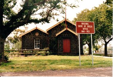
Photograph, Bulla Shire Hall
The building in the image was the original Shire of Bulla council offices where councillors met until 1901 when they relocated to Sunbury and conducted their meetings in the Mechanics Institute Hall later known as the Memorial Hall.This building was originally the offices for the Bulla Roads Board and was the first council office built in the bulla shire'A photocopy of a non digital black and white photograph with a cream border of a historic bluestone building.council offices, bulla bulla township, bulla shire hall, bulla shire council, councillors, bluestone -
Hume City Civic Collection
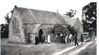
Photograph, St. Mary's Church, Bulla, 1970S
The church in the image is St. Mary's Church of England in Bulla after it was moved from its original location at the corner of Oaklands and Sunbury Roads to the Bulla township adjacent to the former Bulla Shire Officers. The move was necessary because the building was close to the international airport and its location interfered with the airport's signaling system and cracks were appearing in its structure from vibrations caused by lowlying aircraft.A coloured non-digital photograph of a small bluestone church set in an open area with a line of gum trees in the background.churches, st. mary's anglican church - bulla, bulla, tullamarine airport -
Hume City Civic Collection
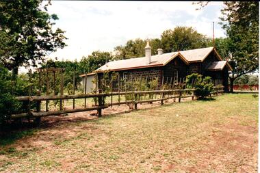
Photograph, Former Shire of Bulla offices, 1970s
The building in the photograph is the former Shire of Bulla offices in the Bulla township. They were built in 1867 and the first meeting took place in the new building on 27th November 1867. Regular council meetings took place there until 1901 when some council meetings were held in the Mechanics Institute (now the Memorial Hall) in Sunbury. In 1963 permanent Shire Offices were built in Macedon Street in Sunbury. A non-digital coloured photograph with rounded corners of a double-fronted bluestone build with a slate roofing and a post and rail fence across the front of the property. -
 Sunbury Family History and Heritage Society Inc.
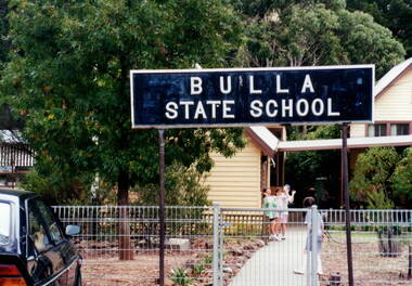
Photograph, Bulla Primary School, Early 1990s
The Bulla Primary School was a semi-rural school in the Bulla township which was established in 1872. It was one of the first government schools to open in the district and continued to function for the following 124 years until December 1996 when the State Government closed the school. After that date, Bulla children were bused to schools in either Sunbury or Greenvale. The school property is now privately owned.Along with Bulla Primary School there were a number of Victorian Government schools closed down and sold to private enterprise in the 1990s.A coloured photograph of the school notice board erected at the main gate of the school. Two of the buildings are partially visible in the background. Four girls are standing on the main pathway.bulla primary school -
 Sunbury Family History and Heritage Society Inc.
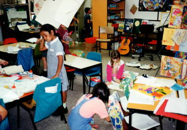
Photograph, Bulla Primary School - Art Class, c1993
The children in the art class were pupils at Bulla Primary School in the early 1990s. Bulla Primary School was a semi -rural school in the township of Bulla, about 10kms from the Tullamarine Airport. There is no evidence of computers or other IT aids in the classroom as these items did not come into widespread use until 2 decades later.A non-digital coloured photograph of six children in an art class at school. The four visible sets of tables and chairs are strewn with art materials and there are shelves in the background where books, folders and other items are kept along with a guitar. art activities, bulla primary school -
 Sunbury Family History and Heritage Society Inc.
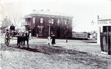
Photograph, Rupertswood Hotel
... to be erected in the Sunbury township. George Millett Royal Hotel ...The photograph was taken at the intersection of Brook and Evans Streets in Sunbury. The two storey bluestone building was the Rupertswood Hotel, which was on the NE corner of the intersection and the single storey Royal Hotel building in the foreground was on the opposite corner. The Millett family originally owned both hotels. The Rupertswood Hotel was demolished in December 1974 to make way for a modern retail store. In 1939 the old Royal Hotel building was damaged by fire and replaced with a two storey red brick building.The Rupertswood and Royal Hotels were two of the earliest hotels to be erected in the Sunbury township.A non-digital black and white photograph of a street photograph featuring an intersection with a two storey bluestone building on one corner and a partial view of a single storey rendered building on the opposite corner. Two children are standing on the side of the road and a man is in a horse-drawn jinker. george millett, royal hotel, rupertswood hotel, evans street, brook street, hotels -
 Sunbury Family History and Heritage Society Inc.
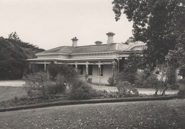
Photograph, 'Glenara' Homestead, 20 August 1952
"Glenara' was the home of Alistair Clark who lived at Bulla which is situated about 20 kms NW of Melbourne in the Deep Creek valley. He was born there in 1864 and lived there throughout his lifetime until his death in 1949. His father established the property during the mid-nineteenth century. Alister Clark was a rose grower and created the very popular 'Lorraine Lea 'rose along with other famous species. A rose garden has been established in the township of Bulla in his memory. He was also an active member of the Victorian Racing Club. The original photograph was published in the Melbourne 'Herald' on 20 August 1952 on page 5.Alistair Clark was a prominent rose grower and developed many rose species which were suitable for Victorian conditions. The homestead is a good example of Victorian architecture built in Victoria in the latter years of the nineteenth century. The house has a heritage listing in the City of Hume Heritage Study.A black and white photograph with a fine white frame, of a Victorian homestead with a a verandah across the front of the house. It is set in a spacious garden with garden beds, lawn and trees.clark, alistair, 'glenara' homestead, roses, bulla, deep creek -
 Sunbury Family History and Heritage Society Inc.
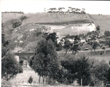
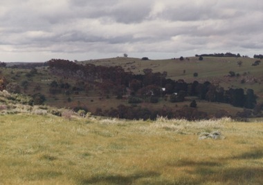
Photograph, Bulla P, 1988
... approaching the township along the Sunbury Road on the west side... the township along the Sunbury Road on the west side of the town ...The photograph was taken from the west side of Bulla Hill near Loemans Road, which is west of the township of Bulla. The rocks outlining the name of the town were a landmark when approaching the township along the Sunbury Road on the west side of the town. They remained there until the school was closed in 1996 and the new owner removed them.A coloured photograph of Bulla Primary School with the word 'Bulla' formed from rocks on the distant hillside. schools, bulla primary school