Showing 516 items matching "strait"
-
 Lakes Entrance Historical Society
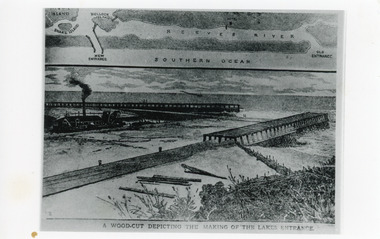
Photograph - Entrance Works, 1880c
Photographic reproduction of woodcut drawing of the building of the entrance and map above of location.Black and white photograph of a woodcut showing dredge working between timber constructed piers on entrance from the lakes to the ocean Bass Strait. Piers unfinished, timber lying around, sand in the entrance. Map above showing position of the lakes, old and new entrances, southern ocean and sand dune vegetation. Lakes Entrance VictoriaA woodcut depicting the making of the Lakes Entrance.public works, dredging, waterways -
 Lakes Entrance Historical Society
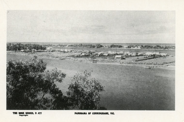
Postcard - Township, Rose Series, 1910c
Plus black and white enlarged copy 15x25Black and white postcard. It shows the rear view of the buildings which front the Cunninghame Arm, or Reeves River, one cottage and three jetties on North Arm, sand hummocks of South shore of Cunninghame Arm and Bass Strait in background. Double storied Kelvin House, later Maranui and Methodist Church identified. Lakes Entrance VictoriaPanorama of Cunninghame Victopography, waterfront, township -
 Parks Victoria - Wilsons Promontory Lightstation
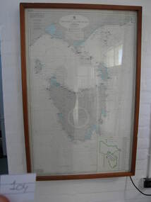
Nautical chart
Used as display in AMSA workshop foyer, Moorabbin, Vic. Nautical charts x 2 , The framed and glazed chart identifies strategic points in the notorious Bass Strait passage, which in the nineteenth century was known as the ‘Eye of the Needle’. It covers the whole of Tasmania, Bass Strait and the islands, and the lower part of Victoria with its coastline between Cape Otway and Gabo Island. The chart has an electric cord connecting it to a wall switch which enables a series of small lights to flash on strategic geographical locations.. While it is not known if it is original to Wilsons Promontory, it certainly elates to its location. A similar chart at Cape Otway shows less of Tasmania and is not electrified. Gabo Island Lightstation has two large framed charts; one is the same as the Wilsons Promontory example but without the lights and the other is entirely different, focussing on the east coast between Point Hicks and Montague Island. The Wilsons Promontory chart is unique as an illuminated version of the other charts and has first level significance if its provenance to the lightstation can be confirmed.The framed and glazed chart has an electric cord connecting it to a wall switch which enables a series of small lights to flash on strategic geographical locations.Yes -
 Queenscliffe Maritime Museum
Instrument - Barometer and Clock mounted on a timber cabinet and 10 associated items from the TSS Nairana, 1915
Bass Strait passenger ship Nairana. Built for Bass Strait ferry operator Huddart Parker & Co. Ltd. of Melbourne during World War One, the Nairana was requisitioned by the Royal Navy and completed as a seaplane carrier, HMS Nairana. Serving from 1917 to 1920 participating in the capture of Archangel during the Bolshevik Revolution. After 1920 she was decommissioned as a seaplane carrier and returned to her Australian owners crossing Bass Strait until she was laid up in 1948. Just off Port Phillip Heads on April 12 1936, a strong wave struck the Nairana, tipping her over for two minutes before she righted herself again. During the horrifying two minutes, four people were drowned, and eight people were injured. The ship was reportedly carrying roughly one tonne of concrete in the hull when she tipped. Reports from the local papers said that it was a tidal wave meanwhile others were saying it was either an earthquake or a total lie. A later paper said that the ship had been caught in a rip at the mouth of the bay, causing the tragedy. The S.S Nairana, was sold for £4,000 (over $170,200 in today’s money!) in 1951 after two years of being stranded on the beach at Port Melbourne, when the moorings broke one night during a storm and drifted ashore, causing her to wreck.Items associated with the TSS/HMS Nairana in its military and civilian roles and items relating to Capt. JF Spence, navigation Officer and possibly later the captain who sailed with the Nairana out of Plymouth after WWI. .01 Barometer and Clock from Dining Saloon .02 Commemorative plaque describing the HMS Nairana's WWI service with timber mount for plaque with information sheet attached. .03 Clock Key .04 Two 2 Log books owned by Capt. Spence containing the navigation calculations for the journey from Plymouth to Melbourne. .05 Huddart Parker hat badge [Capt. JF Spence].Barometer and Clock from dining saloon, TSS Nairana 1917 - 1951 Clock Key - 4 50-No9 Hat badge - HPtss nairana, wwi, bass strait, huddart parker, capt. spence -
 Port Melbourne Historical & Preservation Society
Souvenir - Souvenir flag Spirit of Tasmania, 23 Oct 2022
The red souvenir flag with the Spirit of Tasmania name and TT Line logo was made to commemorate the Bass Strait ferry's last sailing from Melbourne. In July 1985, the Spirit of Tasmania 1 made her first voyage to Melbourne and from that date ferried passengers, vehicles and cargo to and from Devonport, Tasmania. Many passenger ferries have been employed in the Bass Strait passenger service since the 1840's. Ships using preceding the Spirt of Tasmania include the Taroona, Princess of Tasmania and the Abel Tasman. The flag was one of many distributed to the crowds gathered on the foreshore to farewell the ship. With her sister ship, Spirit of Tasmania 2, the red and white ferries had been a familiar sight at Station Pier, Port Melbourne for more than three decades.piers and wharves - station pier, spirit of tasmania, tt-line -
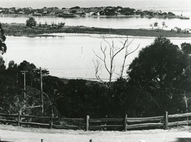 Lakes Entrance Historical Society
Photograph - Carpentertown, Silver Reflections Studio, 1924c
Black and white photograph showing view of New Works. Village on dunes at entrance to Gippsland Lakes from ocean - Bass Strait. View shows SS Gippsland at New Works wharf, Cunninghame Arm, part of Bullock Island and mouth of North Arm, post and rail fence along roadway down Jemmys Point. Lakes Entrance Victoriawaterways, islands, settlement -
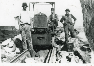 Lakes Entrance Historical Society
Photograph - New Works, 1925c
Also another copy 13 x 20cm, good conditionBlack and white photograph of three men working on original wooden piers at the entrance to Bass Strait. Rail tractor built by J A Day and Son especially for New Works project, powered by dredge car engine, pulled three rail trucks loaded with rocks to reinforce original wooden piers. Three men not identified. Lakes Entrance Victoria public works, construction -
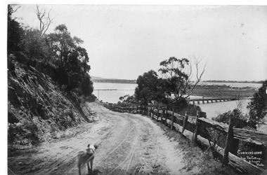 Lakes Entrance Historical Society
Postcard - North Arm bridge. Lakes Entrance Victoria 1905, Cooper, Alexander, 1908c
On back of postcard 'Postage one penny without any communication with communication ordinary letters'|This is the before paired photograph used in the 150 year Lakes Entrance 1858-2008 display|The after paired photograph number is 01147.1|Also one 12 x 16 framed photograph used in room display.|Cooper based in Paynesville 1908-1909Sepia giant post card dirt road leading to the first North Arm bridge. Horse facing two bovines on bridge, mud flat with a small jetty, Club Hotel, sand dunes facing Bass Strait. Post and Rail fence on side of road. Shaggy dog in road. Dieback of melaleuca and reeds on mudflats. Lakes Entrance VictoriaCunninghame from the Cutting A.Cooper photo- right hand cornerroads and streets, bridges, fences, animals, room display -
Phillip Island and District Historical Society Inc.
Document
Letters from Victorian Pioneers 51. John Hart. The career of John Hart after leaving England as a boy and at 22 becoming a Commander of a Bass Strait Sealing Schooner. After losing much of his personal wealth, he lived in South Australia to become Premier three times from 1865 - 71. His association with Phillip Island was Shipping, bark to London.Synopsis of the life of John Hart. Sea Captain, Merchant Trader, Ship Owner, Over lander, Flour Miller and Politician. Born in England 1809, died in Adelaide 28th January, 1873. This article on John Hart was followed by an account of his writings October 1834 on his bark collection enterprise in Westernport and Phillip Island.First commercial venture in Westernport. John Hart and Griffiths Sealer/Whaler "Elizabeth"local history, documents, letters, john hart, politician, merchant trader, black & white photograph, miss elms san remo -
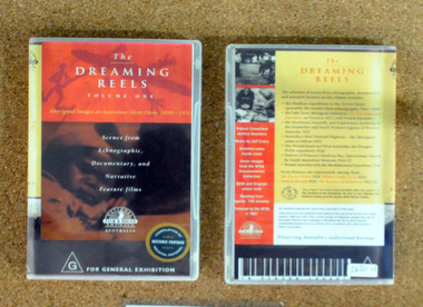 Orbost & District Historical Society
video, The Dreaming Reels, 1997
This disc was a project supported by the Festival of the Dreaming, a festival leading up to the 2000 Sydney Olympic Games.This disc is a significant research tool as it contains contemporary film of the early indigenous people of Australia.A video disc titled, The Dreaming Reels. it is a compilation of scenes from the Hadden expedition to the Torres Strait in 1898, Lake Tyers settlement, Northwest Scientific Exploration in the Kimberleys, the aboriginal camp at Orbost in 1921, the Douglas Wylie Expedition in 1926, Princess Charlotte Bay 1926-1927 and McRobertson's Expedition. It also contains footage from several Australian films depicting Aborigines. aboriginal-history dreaming -
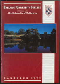 Federation University Historical Collection
Book, Ballarat University College Handbook, 1992, 1992
Ballarat University College was formed in 1990, and is a predecessor organisation of Federation University Australia. Maroon covered book an image of the dam near the Mt Helen swimming pool. Information includes council membership, staff, admission policies and procedures, fees, Aboriginal and Torres Strait Islander Students, Scholarships, accomodation, International Students, courses, units, academic regulations, E.J. Barker Library Regulations, Appeals, Student discipline, Academic Board Policy, Student Union, Enrolment.courses, ballarat university college handbook -
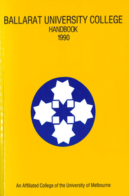 Federation University Historical Collection
Book, Ballarat University College Handbook, 1993, 1992
Ballarat University College was formed in 1990, and is a predecessor organisation of Federation University Australia. Blue covered book an image of the dam near the Mt Helen swimming pool. Information includes council membership, staff, admission policies and procedures, fees, Aboriginal and Torres Strait Islander Students, Scholarships, accomodation, International Students, courses, units, academic regulations, E.J. Barker Library Regulations, Appeals, Student discipline, Academic Board Policy, Student Union, Enrolment.Jeff Stewart name on first page.courses, ballarat university college handbook, jeff stewart -
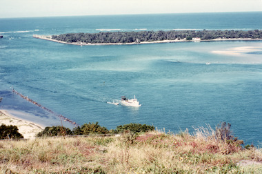 Lakes Entrance Historical Society
Photograph - The Entrance, Fraser, Ian, 1990c
Colour photograph of the lake. It shows a fishing boat with scallop dredge moving up the lake opposite the artificial entrance, grassy edge of Jemmy's Point in foreground above highway guard fence, rock groyne at entry to North Arm, sandy shallows at entry to Hopetoun Channel, scrub covered hummocks of south shore and Bass Strait in distance. Lakes Entrance Victoriaislands, waterways, topography -
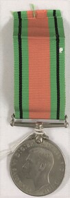 8th/13th Victorian Mounted Rifles Regimental Collection
Medal - McLeish Defence Medal
The Defence Medal is awarded for six months service in a prescribed non-operational area subject to enemy air attack or closely threatened, in Australia and overseas, or for 12 months service in non-prescribed non-operational areas. Within Australia the area is the Northern Territory, north of 14 degrees 30 minutes south, and the Torres Strait Islands between 3 September 1939 and 2 September 1945.World War Two Defence medal 1039-45 awarded to 162841 J McLeish.world war two, wwii, mcleish -
 Federation University Art Collection
Painting, Ronald Edwards-Pepper, 2020
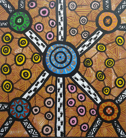
Ronald EDWARDS PEPPER Gunai Ronald Edwards Pepper is the grandson of Dulcie (Dolly) Mullet and Watson Pepper, Ronald’s family moved to Morwell in the 1960s from Lake Tyers Mission. He graduated from Federation University with a Bachelor of Visual and Media Arts in 2017, and has completed several commissions and participated in numerous exhibitions, in Australia and overseas. Artist Ronald Edwards-Pepper is keen to express himself through painting and telling stories of his Gunai/Kurnai ancestors. "My nanna and her stories have been part of my life, and who I have become today, and this influences my artworks. My grand-parents are Dolly Mullet & Watson Pepper. They came from Lake Tyers Mission and moved to Morwell in the 1960s with their mob of kids. Now this is the family home." EDUCATION: 2013-2017 - Bachelor of Visual & Media Arts/Federation University. 2010 - Trainee Mentor in Education (Latrobe Regional Gallery, Morwell) 2008 - Certificate III in Aboriginal Torres Strait Islander in Languages 2007 - Traineeships, Young Ambassador at the Latrobe Regional Gallery, Morwell 2006 - Completed & Graduated - Awarded 'Student of the Year’ 2005 - Certificate IV ATSI Cultural Arts, TAFE Mid-valley Campus Gippsland 2003 - Certificate 4 in Aboriginal and Torres Strait lslander Art & Design, TAFE Mid-valley Campus, Gippsland 2002 - Certificate 3 in Aboriginal and Torres Strait Islander Art & Design, TAFE Mid-valley Campus, Gippsland AboriginalSigned verso "R.Edwards"ronald edwards, aboriginal, gunai kurnai -
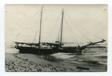 Orbost & District Historical Society
black and white photograph
The “Glengarry” beached at Marlo The schooner Glengarry was a well-known trader on the Gippsland coast and had been stranded on a number of previous occasions including at the Natural Entrance joining the Gippsland Lakes to Bass Strait – Ninety Mile Beach, Lakes Entrance, c 1877 . In May 1898, the vessel struck a submerged object while crossing the Snowy River bar at Marlo and was beached, eventually becoming a total loss. Until t he railway came to East Gippsland goods were shipped from Marlo to Melbourne. This is a pictorial record of a well-known trading ship involved in that river transport.Three copies of a black / white photograph of the Schooner Glengarry wrecked in 1891 at the Snowy River entrance at Marlo.schooner-glengarry shipping transport-orbost -
 Orbost & District Historical Society
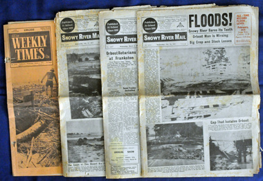
newspapers, February, March 1971
The 1971 flood was the the worst flood on record. At Jarrahmond it was at least 11 metres and up to one and a half kilometres wide on the flats causing enormous damage to the flood plain. Records say that "The brown floodwater stain in Bass Strait could be seen from passing airliners." Considerable damage was done to railway infrastructure, roads and farms. More information from the APRIL, 2008 newsletter by John Phillips. (see orbosthistory.com.au) These newspapers are contemporary records of a significant local event.Four newspapers relating to the floods in 1971. They contain news articles and photographs of the floods in Orbost in early 1971. 2556.1 is the Weekly Times dated 3.3.1971 and has an orange cover. 2556.2 is a Snowy River Mail dated 17.2.1971. 2556.3 is a Snowy River Mail dated 10.2.1971. 2556.4 is a Snowy River Mail dated 3.3.1971.floods-orbost-1971 snowy-river-mail weekly-times newspapers -
 Lakes Entrance Historical Society
Photograph - Bullock Island, Fraser Ian, 1920c
Black and white photograph of Bullock Island, showing Prince's Highway from North Arm bridge, east end of Bullock Island and bridge, entrance to Bass Strait and sand dunes along Cunninghame Arm. Western end of Bullock Island bridge raised to allow small boats access to North Arm and Cunninghame Arm, became known as Humpy Bridge. Lakes Entrance Victoria islands, waterways, topography, bridges -
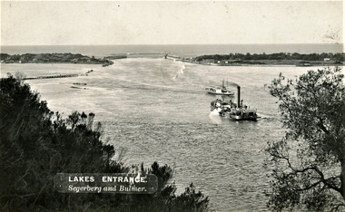 Lakes Entrance Historical Society
Photograph - The Entrance, Segerberg and Bulmer, 1910 c
Also enlargement 17 x 23 cmBlack and white photograph showing view from Jemmys Point of the entrance to the Gippsland Lakes from Bass Strait. Pioneer dredge in centre foreground, and steamer JCD. Cottages and works buildings including Rocket shed on eastern dunes, Schnapper Cottage on far right western dune. Rock groynes and tip of Bullock Island centre left. Vegetation in foreground. Lakes Entrance VictoriaLAKES ENTRANCE Segerberg and Bulmerships and shipping, topography, jetties, houses -
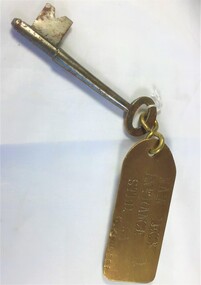 Queenscliffe Maritime Museum
Functional object - Key
The SS George Kermode was an Australian Steam Bucket Dredger of 1,380 tons built in 1914 by Fleming & Ferguson, Paisley. In 1917 she was acquired by the Australian Government. In 1941 she was acquired by the Melbourne Harbour Trust Comm. and renamed Geo. Kermode. On the 1st April 1976 she was scuttled near Pyramid Rock off Phillip Island, Bass Strait, Australia. Read more at wrecksite: https://www.wrecksite.eu/wreck.aspx?31789Key to main deck entrance with brass tag [starboard side of G. Kermode]Main deck entrance stbd G. Kermodekey, dredger, ss george kermode -
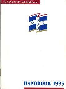 Federation University Historical Collection
Book - Handbook, University of Ballarat Handbook, 1995, 1995
The University of Ballarat was formed in 1994, and is a predecessor organisation of Federation University Australia. White covered book with blue and maroon printing and logo. Information includes staff, admission policies and procedures, fees, Aboriginal and Torres Strait Islander Students, Scholarships, accomodation, International Students, courses, units, academic regulations, E.J. Barker Library Regulations, Appeals, Non-Sexist language, Student discipline, Academic Board Policy, Student Union, Enrolment, Parking, Campus plan, Locality map.university of ballarat handbook, courses, student association, marg thorne, mary rhyne, vicki anwyl, jenny geddes, wendy keyte, lynne billstone-convery, toni palmer, mary williams, steve blomeley, jenny gallagher, tracey fox -
Port Melbourne Historical & Preservation Society
Photograph - Bass Strait ferry, Oct 1998
Four colour photographs taken from Bass Strait Ferry .01 - outer end of Station Pier with City backdrop .02 - View to beach and London Hotel and east end of Beacon Cove .03 - Station Pier Gatehouse with Beacon Cove and two of the Beacon Cove towers .04 - View to Port Melbourne Beach, London Hotel, Beacon Cove and City skyline viewing platform/folly in foregroundpiers and wharves - station pier, built environment, london family hotel, beacon cove -
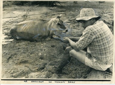 Orbost & District Historical Society
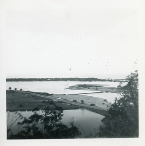
black and white photograph, 11 February 1971
This photograph was taken during the 1971 floods at Orbost. The 1971 flood was the the worst flood on record. At Jarrahmond it was at least 11 metres and up to one and a half kilometres wide on the flats causing enormous damage to the flood plain. Records say that "The brown floodwater stain in Bass Strait could be seen from passing airliners." Considerable damage was done to railway infrastructure, roads and farms. More information from the APRIL, 2008 newsletter by John Phillips. (see orbosthistory.com.au)This is a contemporary pictorial record of a significant local event.A large black / white photograph of a man, dressed in shorts and a checked shirt, sitting on a fence post surrounded by mud. He is holding on to the leg of a cow which is stuck in the mud.on front - "Mr Harrison on Tracey's Dairy" on back - " Herald 11 Feb 1971"floods-orbost-1971 tracey-dairy natural-disaster-flood -
 Bendigo Military Museum
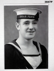
Photograph - PHOTOGRAPH, RAN, C.1939 - 40
George Bradshaw MORRISS No 23670 enlisted in the RAN on 23.10.1939 aged 17 years. He was posted to Australian light cruiser, HMAS Perth. HMAS Perth was torpedoed & sunk by the Japanese Navy in the Battle of the Sunda Strait, between the islands of Java & Sumatra in late February 1942. Approximately half of the crew were lost & the remainder taken into captivity. 106 died as POWs. George died at Sandakan on 29.5.1945. He is rembered on the Sandakan Memorial in Bendigo, Victoria.Black / white photo of sailor, George Bradshaw MORRISS in uniform including hat.On hat band in white: “H.M.A.S. PERTH”photograph, ran, perth, pow, sandakan -
 Orbost & District Historical Society
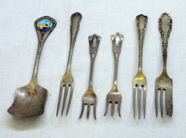
cutlery, first half 20th century
MS Princess of Tasmania was an Australian-built roll-on/roll-off passenger ship, built by the State Dockyard in Newcastle, New South Wales for the Australian National Line. Laid down on 15 November 1957, she was launched on 15 December 1958. The Princess of Tasmania sailed on her maiden voyage on 23 September 1959. On entering service, she was used on the Devonport to Melbourne route across Bass Strait. The ship continued operating until 1972, Five silver-plated forks and one spoon. The sugar spoon is a souvenir of the Princess of Tasmania. 1590.2 and .5 are narrow forks. 1590.3 and .4 have splayed tines. 1590.6 is a cake fork.On back of spoon : EP&NS *1 Various marks on backs of forks with EP&NScutlery silver-plated princess-of-tasmania -
 Queenscliffe Maritime Museum
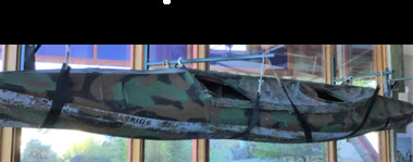
Vehicle - Kayak, Commandos
The remarkable story when 74 soldiers fought in vain to save the lives of their mates off Portsea as 3 soldiers died. Tragically, Privates Roger Wood and Edward Meyer, and Warrant Officer George "Taffy" Drakopoulos, died. Please Note: "The Rip" is also known as "The Heads", which is a dangerous stretch of water connecting Port Phillip Bay and Bass Strait. This is the only entrance for all shipping into Port Phillip Bay and to and from the Port of Melbourne, Victoria, Australia.Kayak of a similar type as those used during the ill-fated army exercise with loss of life in the rip.rip disaster, commandos, kayak, military history - army -
 Flagstaff Hill Maritime Museum and Village
Functional object - Wood sample
This oak wood sample is part of the wooden barque, the Grange, built in 1840. The wood sample was recovered from the shipwreck of the Grange in around 1968, 110 years after the Grange was wrecked (see below for further details on the Grange). It is part of the John Chance Collection. THE GRANGE, 1840-1858- The wooden barque ’Grange’ was a three-masted ship built in Scotland in 1840 for international and coastal trade. On March 22, 1858, the Grange set sail from Melbourne under Captain A. Alexander, carrying a cargo of ballast. The barque had left the Heads of Phillip Bay and was heading west along the Victorian coast towards Cape Otway. The ship struck Little Haley’s Reef at Apollo Bay due to a navigational error and was stuck on the rocks. The crew left the ship carrying whatever they could onto the beach. Eventually, the remains of the hull, sails and fittings were salvaged before the wreck of the Grange broke up about a month later. About 110 years later, in 1968, the wreck of the Grange was found by divers from the Underwater Explorers Club of Victoria. They were amazed to find a unique, six to nine pound carronade (type of small cannon) and a cannonball on the site. There have been no other similar carronades recorded. In that same year the anchor of the Grange was recovered by diver John Chance and Mal Brown. The wood sample is significant historically as an example of hardware used when building wooden ships in the early to mid-19th century. The sample is historically significant as an example of the work and trade of blacksmith. The sample is also has significant as it was recovered by John Chance, a diver from the wreck of the Grange in the 1968. Items that come from several wrecks along Victoria's coast have since been donated to the Flagstaff Hill Maritime Village’s museum collection by his family, illustrating this item’s level of historical value. The sample is historically significant for its association with the 1840s wooden barque, the Grange. The Grange is an historical example of a Scottish built vessel used for international and coastal trader of both cargo and passengers in the mid-19th century. The Grange is an example of an early ship, designed with a wooden hull. It is significant as a ship still available to divers along the south coast of Victoria, for research and education purposes. The Grange is an example of a mid-19th century vessel that carried a weapon of defence onboard. Wood sample, oak wood fixed between plates and secured by a washer and bolt. There are five layers, each decreasing in size from base to the top. The bottom is a five-sided copper plate, above it is the oak sample that is crumbling and fragile, then a half-disc metal plate, then a square metal washer, then a round metal bolt head. The metal plate has unequal sides, the longest is parallel to the strait side of the half disc. flagstaff hill, warrnambool, flagstaff hill maritime museum, maritime museum, shipwreck coast, flagstaff hill maritime village, great ocean road, west coast trader, apollo bay, mid-19th century shipwreck, the grange, scottish barque, little henty reef, captain a alexander, underwater explorers club of victoria, 1840s carronade, vhr 5297, coastal trader, wooden shipwreck, john chance, wood sample, wooden ship, oak timber, ship fitting -
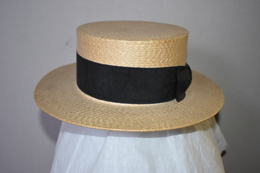 Warrnambool and District Historical Society Inc.
Hat, Boater, Early 20th century
This hat has the brand name or model, ‘The Solent’ which is the name of the strait that separates the Isle of Wight from mainland England. Boater hats such as these were mostly worn for informal occasions and were usually associated with sporting events such as boating and sailing, particularly in Britain. Hats of this type were also part of the school uniform of some Australian schools, usually prominent private schools with a British tradition, in the first half of the 20th century and there may be some schools still using the style today. This boater is of interest as an example of the informal head gear worn by men in the late 19th and early 20th centuries. It will be useful for display.This is a cream straw boater hat with a flat circular crown and round brim. The straw is stiffened and plaited. There is a black material band ending with a black bow around the base of the crown. The hat has brown leather internal lining with a cream cord insert for altering the inside size of the hat. Inside the hat is a printed shield with the maker’s details and some gold ornamentation with printed material. The Criterion Brand Reg. No. 15094 The Solent Extra Quality Copyright. vintage headware, history of warrnambool -
Port Melbourne Historical & Preservation Society
Photograph - SS Nairana, Feb 1951
The SS Nairana was launched 1915 by William Denny & Brothers in Dumbarton Scotland the 3,402 ton steamer was requisitioned by the Royal Navy and served during WW1. In 1922 she was transferred to Tasmanian Steamers and, apart from again being requisitioned for war service in WW2, was used as a Bass Strait ferry until 1948. The Nairana was blown ashore onto Port Melbourne beach during a severe gale on 19 February 1951. After salvage what remained of the wreck was blown up in 1954. B & W photograph of SS Nairana with lifeboats joining shipwreck to Port Melbourne beach.transport - shipping, ss nairana -
Port Melbourne Historical & Preservation Society
Photograph - SS Nairana, C.1951
The SS Nairana was launched 1915 by William Denny & Brothers in Dumbarton Scotland the 3,402 ton steamer was requisitioned by the Royal Navy and served during WW1. In 1922 she was transferred to Tasmanian Steamers and, apart from again being requisitioned for war service in WW2, was used as a Bass Strait ferry until 1948. The Nairana was blown ashore onto Port Melbourne beach during a severe gale on 19 February 1951. After salvage what remained of the wreck was blown up in 1954. B & W aerial photograph of SS Nairana and Port Melbourne foreshoress nairana, transport - shipping