Showing 671 items
matching tunnelers
-
 Bendigo Historical Society Inc.
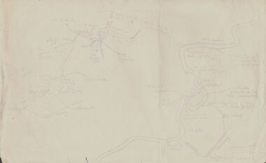
Document - PETER ELLIS COLLECTION: SKETCH OF THE BARFOLD GORGE
Two hand sketched maps on same sheet of paper, one of the location of the Barfold Gorge in relation to surrounding towns, Mt Alexander and Turpin;s Falls. The second map is a part of the Campaspe River location of the Barfold Gorge. Shown is the location of columns, pools, type of rock, Mitchell's Falls, tunnel, cave, Queen's Falls, house, windmill, fences and places where access to the bottom of the gorge is possible. Car track and scale of 1 mile = 6 inches are also shown.place, land, barfold gorge, peter ellis collection, mitchell's falls, queen's falls, turpin's falls -
 Bendigo Historical Society Inc.
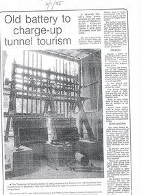
Newspaper - LONG GULLY HISTORY GROUP COLLECTION: OLD BATTERY TO CHARGE-UP TUNNEL TOURISM
BHS CollectionThree photocopies of a newspaper article titled Old Battery to charge-up tunnel tourism. The date 11/1/85 is written at the top of the article. There is a photo of the battery mentioning it was the Thompson's Foundry battery and it was being re-erected at Maldon, near Castlemaine. It has been in far of Victoria to crush rock taken from mines there. The battery will be one of the attractions in the Parkin's Reef Reserve being developed by the Conservation, Forests and Lands. Also mentioned is the work of volunteers, grants they received, restoration and tourism.bendigo, history, long gully history group, the long gully history group - old battery to charge-up tunnel tourism, thompson's foundry, parkin's reef reserve, conservation forests and lands department, carman's tunnel, north british mine, parkin's reef, carman's tunnel committee, dr doug kemsley, prospectors' and miners' association of victoria, ken garden, north british mine, george ellis -
 Melbourne Tram Museum
Document - Report, P. J. Pringle for the Tramway Board, "Yoke Frames for Supporting line pulleys in tunnel", 18/10/1916 12:00:00 AM
Report - four foolscap sheets, clipped in top left hand corner titled "Yoke Frames for Supporting line pulleys in tunnel", dated 18/10/1916 by Mr. P. J. Pringle for the Tramway Board. Report on issues with the cable tramway yokes looking at the problems with wear, cracking, dimensions, and depth that the grip could run. Noted differences between the south and north sides of the system. Work done by Mr Blackwell and Mr. Watt. Has two sheets of tables listing the problems.trams, tramways, cable trams, cable grip, cables, maintenance, track repairs -
 Ringwood and District Historical Society
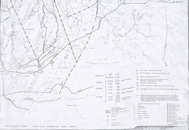
Map - Maps, Geological Map Donvale to Chirnside Park, also Victorian Railways Maps of Hawthorn to Lilydale Line incl Ringwood to East Ringwood - 1881
Faint photocopies of sections of larger maps. Geological map includes location of mine shafts circa 1920.Victory Shaft, North Victory Shaft, South Caledonia Shaft, Caledonia Shaft, North Caledonia Shaft, Black Swan Shaft, Reward Shaft, Consols Shaft, Blocks Shaft, Devonshire Shaft, Crown Shaft, Yarra Tunnel Reef Working, Bright's Shaft, Kingwood Antimony Company Shaft (Boardman's Shaft), Southern Shaft. -
 Orbost & District Historical Society
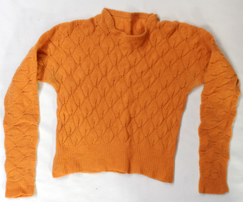
knitted jumper, 1938-1940
This was knitted by Marjorie Burton during WW11 in England. She used to knit while in an air raid shelter escaping the bombing with her young daughter. Air raid shelters were built specifically to serve as protection against enemy air raids. However, pre-existing structures such as underground stations (tube or subway stations), tunnels, cellars in houses or basements in larger establishments, and railway arches, above ground, were suitable for safeguarding people during air raids. This item is an example of a handcrafted item and reflects the handcraft skills of women necessary during WW11 when clothing became scarce. Clothes rationing began on June 1, 1941, two years after food rationing started. Clothes rationing ended on 15 March 1949.A hand-knitted orange/tan woolen jumper. It is a lady's long-sleeved jumper.handcraft knitting ww11 -
 Warrnambool and District Historical Society Inc.
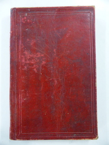
Book, John Ross notebook, 1890s
This small note book belonged to John Ross, the Warrnambool Town Surveyor and Engineer (1889-1906 & 1913-1914). The book lists the levels taken for the benefit of contractors undertaking jobs for the Warrnambool Council from 1898 to 1902. The jobs include ‘Russells Creek from the Merri River upwards’, ‘Outlet at the Flume’, ‘Guns at the Battery’ and Drainage from the Terminus Hotel to the end of the Japan Street Tunnel’. John Ross was also in private practice with the architectural firm of Ross and Jackman. This notebook is of considerable interest because it is an original note book that belonged to John Ross, the Warrnambool Town Surveyor and Engineer in the late 19h century and early 20th century. The note book contains important information on the engineering projects in Warrnambool and district from 1898 to 1902. This note book has a red leather cover. The cover is a little creased. The inside pages have ruled red lines and printed headings regarding the levels taken of a site and the location of the site (1898 to 1902). The engineer’s entries in the printed columns are handwritten , mostly in pencil. The inscription on the first page is handwritten in black ink. ‘Jno C Ross, Town Surveyor Wbool 19/5/98’ john ross, warrnambool town council, history of warrnambool -
 Eltham District Historical Society Inc
Audio - Audio Recording, Jim Connor; Maroondah Aqueduct, 11 Jun 2022
This significant historical link in Melbourne’s water supply system is perhaps something we have taken for granted, or not even really noticed…it is just there! Built between 1886 and 1891 to transfer water from the Watts River near Healesville to the reservoir at Preston this aqueduct was 66 km in length and included open channels, tunnels and the use of inverted siphons to keep water flowing, to eventually service Melbourne and suburbs. At this meeting Jim Connor will talk about the challenges and achievements involved with this extraordinary project.1:09:10 duration Digital MP3 file; 23.7 MBaudio recording, eltham district historical society, meeting, society meeting, eltham, jim connor, maroondah aqueduct -
 Melbourne Tram Museum
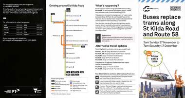
Pamphlet, Public Transport Victoria (PTV), Buses replace trams along St Kilda Road and Route 58, Oct. 2022
Pamphlet - Buses replace trams along St Kilda Road and Route 58 - issued for the track relocation at Domain Junction / Anzac station during the period 27-11-2022 to 17-12-2022. Actual work took a day longer due to weather. Similar pamphlets would have been issued for other routes that used St Kilda Road. Includes maps, alternative routes. Issued by Public Transport Victoria. Part of the Metro tunnel works.Yields information about the reconstruction of Domain Junction for the future Anzac station.Pamphlet - four fold DL - full colour on semi gloss paper. Two copies held.tramways, route 58, anzac station, domain interchange, track work, bus replacement -
 Federation University Historical Collection
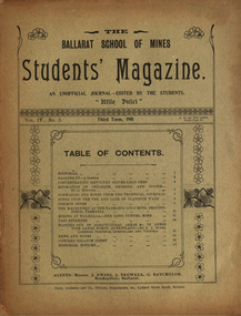
Booklet, Ballarat School of Mines, Student Magazine, Third Term, 1901, 1901
Articles include: Concentrating difficult silver-lead ores, Estimation of chlorine, bromine and iodine (by D.Runting. Summaries and notes from the technical journals, Notes upon the use and care of platinum ware, Common sense, The machinery at the Tasmania gold mine, Beacons-Field, Tasmanina, Mining at Walhalla - The long tunnel mine, Past students, Mapping out of agricultural areas &c., in dense vine lands, North Queensland (by R. A. Suter. Licensed surveyor, Queensland and Victoria), News and notes, Concert balance sheet, Editorial notices.Soft covered magazine of 16 pages. silver-lead ores, estimation of chlorine, bromine and iodine (by d.runting), platinum ware, tasmania gold mine, beaconsfield, tasmania, mining at walhalla, long tunnel mine, vine lands, north queensland, r. a. suter, photography class, boer war, alumni, thomas vincent, basil sawyer, o. e. jager, a. s. burdekin, t. phillipson, glen macpherson, tom uthwatt, marcus marks, r. j. allen, cecil eales, cecil wakley, adam morton, e.p. lewers, harry leggo, jack hill, berk, nickolls, h. burrows, percy osborne, j. brangan, chris evans, adamson, alford, r. evans, arthur "thomas" atkins, charles campbell, hardy, a. basil reid, h. l. krause, k. grant, m. gray, a.b. reid, h. alston, playford, j. a. reid, s. b. vial, f. a. marriott, f. lush, c. whyte, karl moore, r. robin, w. j. lakeland, e. trend, h. l. giles, r. mccracken, k. bryron moore -
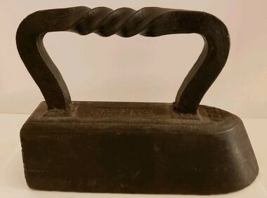 Wodonga & District Historical Society Inc
Functional object - CARRON brand Tailor's "Goose" Iron With Twist Handle, Carron Iron Company, c1850s - 1900
THE CARRON COMPANY The Carron Company established its ironworks on the banks of the River Carron in Falkirk, Stirlingshire, Scotland, in 1759, and became an incorporated company in 1773. The company was the largest ironworks in Europe during the 19th century. It supplied ammunition and armaments, steamboat engines, pig iron, cast iron goods such as flat irons, balustrades, fire grates and bath tubs, pillar boxes and telephone boxes, and even cast iron rings for underground tunnels. In 1982 it became insolvent and was taken over by the Franke Corporation, using the brand Carron Phoenix.This iron is representative of the domestic appliances used throughout Australia up until electricity became widely available for domestic use.An antique Carron iron made of solid cast iron. These types of iron were nicknamed "sad irons" from the Old English where "sad" was originally a word which meant "heavy and solid". Typically, there would be two irons simultaneously in use: one to iron with and one being heated up on the stove or in the fire. This iron has a flat bottom and back and it curves to a point at the front. It has a goose neck handle which has a twist. Irons such as this were often given the name "goose" irons. Near the front of the iron on its top '11' is marked. These irons were used from the late 18th to mid 20th centuries before electricity was widely available in all areas, particularly in rural environments.On top of iron "CARRON"flat irons, domestic appliances -
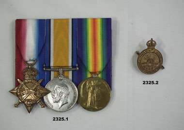 Bendigo Military Museum
Award - MEDAL SET WW1 & BADGE, Post 1919
Horace Eli Hambly No 794 enlisted on 7.12.14 in 3rd reinforcements 4th Light Horse Regt age 20 years 10 months. Embarks for Eygpt 3.2.15, hospital Gallipoli 10.9.15 classed "Enteric", returns to Australia on 20.10.15. He goes AWOL on 24.3.16, classed as a deserter on 17.4.16. He re enlists in NSW on 16.7.17 as David Edward Miles No 7856 3rd Aust Tunneling Coy, he then confesses and embarks for England on 21.11.17, hospital with PUO on 27.6.18, discharged from the AIF on 17.7.19. .1) Medals, court mounted, set of (3) re H.E Hambly. 1. 1914-15 Star. 2. War Medal 1914-18 3. Victory Medal 1914 - 1919 .2) "Returned from Active Service Badge". Metal, gold colour, round with crown at top, centre has Rising Sun with AIF under..1) "794 Cpl H.E.Hambly 4 L.H.R A.I.F" .2) "201258"medals, badges, military -
 Bendigo Historical Society Inc.
Photograph - COLIBAN MAIN CHANNEL, July,2009
Photograph - colour. All photographs are of the Coliban Main Channel. Photo's 1,2,3,4 + 5 = were taken from South Mandurang Road, Spring Road end. Photo's 6,7,8,9,10,11,12 + 13 = were taken top of dirt road section of Springs Road. Photo's 14 + 15 = Taken between Sedgwick and North Harcourt, used to be called 'Prestonvale'. Photo No.14 is called Wirths Tunnel, 633 metres in length. Three more sheets of photo's of the Coliban Main Channel, between Sedgwick and Harcourt North. If more info.Ray Smith and Phil Wilkin - Bendigo Historical Society.place, water, coliban race, coliban main channel. -
 Bendigo Historical Society Inc.
Document - MCCOLL, RANKIN AND STANISTREET COLLECTION: REPORT ON CASTLEMAINE, MALDON & OTHER AREAS
Copy of a typewritten report on Castlemaine, Maldon, and other areas of the main Bendigo District by H.W. Gepp Consultant on Development to the Commonwealth Government. W. Baragwanath Director of the Geological Survey of Victoria and F.L. Stillwell D.Sc. Council for Scientific and Industrial Research. Mentions Castlemaine, Fryertown, Maldon, South German Mine, Mt. Tarrengower Tunnel, Raywood, Sebastian, Wedderburn, Inglewood, Whipstick, Lightning Hill, Black Forest Mine, Old Tom Mine. Trentham. Dated 17th September 1931. Consists of 19 Foolscap PagesH.W. Gepp, W. Baragwanath, F.L. Stillwell.gold, mining, report, gold mining, bendigo, castlemaine, maldon -
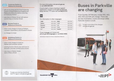 Melbourne Tram Museum
Pamphlet, Public Transport Victoria (PTV), "Buses in Parkville are changing", Feb. 2018
Pamphlet - 3 fold DL colour printed titled "Buses in Parkville are changing", advising of changes to routes 401, 402, 403,, 505 and 546 buses due to the construction of the Metro Tunnel station in Grattan Street from 18/2/2018. has a map showing the changed bus routes and tram routes. Parkville Station. Issued under the name of Transport for Victoria with a PTV web address. .1 - hanging pamphlet giving details of the proposed changes - cut to be hung on rails inside a bus.trams, tramways, buses, metro tunnel, grattan st, railways -
 Victorian Interpretive Projects Inc.
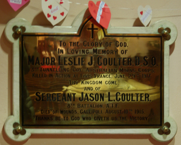
Photograph - Colour, Clare Gervasoni, Plaque commemorating Leslie and Jason Coulter, 09/05/2015
Colour photograph of a brass plaque in the Ballarat Anglican Cathedral.To the Glory of God in Loving Memoryof Major Leslie J. Coulter. D.S.O. 3rd Tunnelling Coy Australian Mining Corps Killed in Action at Loos, France, June 29, 1917 ":Thy Kingdon Come," and of Sergeant Jason L. Coulter 8th Battalion, A.I.F. Died of Wounds, Gallipoli, August 10th 1915. "Thanks be to God who Giveth us the Victory.leslie coulter, jason coulter, world war one, commemorative plaque -
 Federation University Historical Collection
Magazine - Booklet, Ballarat School of Mines, Student Magazine, Third Term, 1910, 1910
Booklet of 30 pages. Table of Contents: Editorial, Theatre party, Economic Geology of Victoria, Obituary - Andrew Anderson Esq., J. P., Our President, Coal, History of roasting at Kalgoorlie, Melbourne electric supply co, Australian coinage, Pilbarite, Liquid air, What is the "Expression" for "Success in the electrical engineering professions?", Students' annual excursion to Melbourne, Melbourne city council's electric light station, Modern tunneling, Estimation of copper, Oxozone - a fume destroyer, News and notes, Sporting notes, Answers to correspondents, Past Students, Editorial notes. Images.Pink coloured booklet of 32 pages. Page 25 outline the whereabouts of past Ballarat School of Mines Students: A.R. Booth, W.T. Lakeland, Lewis Westcott, Leo M. Seward, Reginald Williamson, Stanley White, Clyde Allan, Charles Laird, W.E. Eyres, Virgil Tucker, H. Hawkesworth, H.J. Saw, H. Meadows, Fred G. Brinsden, C. Stevenson, Fred Treloar, J. Peart, E.M. Weston, Dick Galloway, Richard Galloway, G.R. Curry, H. Meadows, Will Watson, Don Cameron, Eric Bieske, Cliff Garrard ballarat school of mines, staff, obituary - andrew anderson, esq., j.p., l. w. g. buchner, a. r. booth, w. t. lakeland, lewis westcott, leo. m. seward, reginald williamson, stanley white, clyde allan, charles laird, w. e. eyres, virgil tucker, h. hawkesworth, h. j. saw, h. meadows, fred. g. brinsden, c. stevenson, fred treloar, j. peart, e. m. weston, dick galloway, h. b. bennetts, g. r. curry, will watson, don. cameron, eric bieske, cliff. garrard, lindsay d. cameron, phil brown, w. p. avery, j. foster, j. bickett, f. h. inglis, g. davenport, l. c. courbould, t. lennon, h. wilkins, g. h. reid, c. hesselmann, e. fraser, reginald callister, a.r. booth, w.t. lakeland, leo m. seward, w.e. eyres, h.j. saw, fred g. brinsden, e.m. weston, richard galloway, g.r. curry, don cameron, cliff garrard -
 Kiewa Valley Historical Society
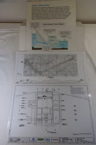
Plans - 2 Southern Hydro - Bogong Power Development and 1 Poster - Hydro-Electricity
Southern Hydro owned the Kiewa Hydro Electric Scheme in 2006. Southern Hydro owned the Kiewa Hydro Electric Scheme in 2006.Laminated A3 sheets The two Southern Hydro Bogong Power Development are black and white. 1. Tunnel and Civil Works / Power Station / Cross Section Sheet 4 of 6 Dated: June 2006 (Also see KVHS 1438) 2. Bogong Power / Development Waterway. Waterway Plan & Longsection / with Boreholes & Seismic Lines (Also see KVHS 1438) 3. Title: Hydro-Electricity in blue at the top and half-way down a blue and brown diagram titled 'Hydro-Electric Power Station'. At the bottom the title 'What is a watt?' southern hydro 2006, bogong power development -
 Federation University Historical Collection
Book, Mining Engineers Handbook Volume 1 & 2, 1941
The book was used by Charles Bacon who studied at the University of Nevada in the late 1930s/early 1940s. Bacon worked at Bunker Hill Mines and Kellogg Idaho, before arriving in Australian in 1951. He worked for CN Myers, a company involved with paper converting. CN Myers was a family business (on Charles Bacon's maternal line). Robert Peele was Professor Emeritus of mining Engineering at the School of Mines, Columbia University.Maroon hardcovered books. .1) Volume 1 - Chapters include Mineralogy, Geology and Mineral Deposits, Earth Excavation, Explosives, Rock Excavation, Tunneling, Shaft Sinking in Rock, Shaft sinking in Unstable and Waterbearing Ground, Boring, Underground Transport, Mine Ventilation. .2) Volume 2 - Chapers include Compressed Air Practice, Electric Power for mine Service, Surveying,Underground Surveying, Mine Geologic Maps and models, Cost of mining, Mining Laws, Ore sampling, Assaying, Aerial Tramways and Cableways, Gold Amalgamation and Cyanidation, etc.Inside front cover "Charles Bacon"charles bacon, mining engineering, mining, engineering, university of nevada, mackay school of mines, explosives, timbering -
 Eltham District Historical Society Inc
Photograph - Digital Photograph, Alan King, Maroondah Aqueduct Siphon Bridge over the Plenty River, 26 January 2008
Opened in 1891, the bridge formed part of the Maroondah Aqueduct carrying water from Watts River near Healesville to the reservoir at Preston where it joined Melbourne's metropolitan water system. Covered under Heritage Overlay, Nillumbik Planning Scheme. Published: Nillumbik Now and Then / Marguerite Marshall 2008; photographs Alan King with Marguerite Marshall.; p99 Built to supply thirsty Melbourne in the late 19th century, the siphon bridge spanning the Plenty River off Leischa Court, Greensborough, was part of an engineering masterpiece. Opened in 1891, the bridge formed part of the Maroondah Aqueduct carrying water from the Watts River near Healesville to the reservoir at Preston where it joined the metropolitan distribution system. A major link in Melbourne’s water supply, it also had a huge impact on communities, which mushroomed along its route. Named after the Aboriginal word for the area around the Maroondah Reservoir, the Maroondah Aqueduct was fully operational until the 1970s. Since the 1980s the land along parts of the aqueduct have been used for walking and bicycle riding, shaded in places by Monterey Pine trees planted to stabilise the surrounding ground. From 1857 the Yan Yean Reservoir supplied Melbourne’s water but the growing city needed additional catchments.1 In 1886 work began on a weir on the Watts River to enable the aqueduct to carry most of the river water 41 miles (66km) to Melbourne. The aqueduct, built by the Board of Works, is the oldest remaining aqueduct near Melbourne and was probably the first built with concrete.2 Although the aqueduct is now only used between the Maroondah and Sugarloaf Reservoirs, it can still be traced across the Shire. It extends from the Maroondah Reservoir through Christmas Hills, Kangaroo Ground, Research, Eltham, St Helena and then previously wound west through Greensborough to Reservoir.3 Built by horse and manpower the aqueduct gravity fed 25 million gallons (113.6ML) of water a day to Melbourne along a gradient of one foot to the mile. It included 25 miles (41km) of open concrete and brick channel, six miles (10km) of tunnels, and nine miles (15km) of 14 inverted siphons of riveted wrought-iron across creeks. Bricks for the aqueduct were made from clay found near the sites and remains of several kilns can still be found between Kangaroo Ground and Christmas Hills. Building the aqueduct transformed local communities. An abattoir was established at Christmas Hills. Grog shanties and labourers’ camps sprang up and local courts dealt with cases of ‘petty pilfering and boisterous behaviour’.4 The Kangaroo Ground school population jumped to 91, crammed into a room with one teacher. Miners who built the tunnels camped just north of Churinga in Greensborough – then called Tunnel Hill Camp – and adjacent to the Evelyn Arms Hotel. The miners’ high spirits were sometimes quenched in horse troughs or by a ‘welt under the ear and kick on the behind’ as the local constable calmed them down rather than lock them up.5 But the growing city of Melbourne needed more water, so the O’Shannassy catchment, east of Warburton, was added to the system in 1914. In 1920 work began on the present concrete Maroondah Dam one mile (1.6km) from the weir on the Watts River. The aqueduct capacity was thus doubled to 50 million gallons (227ML) a day.6 Intense land development threatened to pollute the open water supply, so channel sections were replaced with large pipes. In the late 1960s a large water main was built from the tunnel outlet at Research and extended through St Helena and Greensborough, so this section of the aqueduct was taken out of use. Long sections of the unused open channels in Greensborough and Bundoora were destroyed, but the old channel in Research and Eltham North remained largely intact. In the 1970s, the Sugarloaf Reservoir was constructed, inundating 445 hectares of land in Christmas Hills. Sugarloaf was officially opened in 1980 and serves as a water storage and treatment plant supplying Melbourne. In the early 1980s pipes replaced the section from Sugarloaf Reservoir to the tunnel entrance at Kangaroo Ground. The Research-Kangaroo Ground tunnel operates as part of the pipeline system.This collection of almost 130 photos about places and people within the Shire of Nillumbik, an urban and rural municipality in Melbourne's north, contributes to an understanding of the history of the Shire. Published in 2008 immediately prior to the Black Saturday bushfires of February 7, 2009, it documents sites that were impacted, and in some cases destroyed by the fires. It includes photographs taken especially for the publication, creating a unique time capsule representing the Shire in the early 21st century. It remains the most recent comprehenesive publication devoted to the Shire's history connecting local residents to the past. nillumbik now and then (marshall-king) collection, maroondah aqueduct, pipe bridge, siphon bridge -
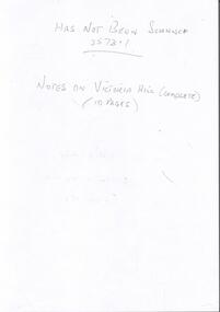 Bendigo Historical Society Inc.
Document - RAE'S CRUSHING BATTERY - THE RICH VICTORIA HILL & ITS HISTORICAL ASSOCIATIONS
The first five pages are photocopies of photos:- 2 of Rae's Crushing Works; Victoria Quartz on Victoria Hill, Ironbark; Looking North from Old Chum Hill to the Victoria Hill; Victoria Hill - from Rae's Open Cut. Introduction covers location of buildings and mines. Mentioned are:- North Old Chum Mine, Ballerstedt's First Open-cut, Quartz Veins (Spurs), rock formations pitching North, Prospecting shafts 1929, Concrete dam, Engine beds of Lansells Big 180 Mine, Lansells Big 180 Shaft, twenty stampers crushing battery, Lansell's Cleopatra Needle type chimney, Victoria Quartz Mine, Victoria Quartz dams, Rae's Open-cut, Quartz once roasted here to an intense heat, Anticlinal Arch New Chum Line, small primitive tunnels, Prospecting tunnels, Floyd's small 5 head crushing battery, Great Central Victoria (Midway) Shaft, Great Central Victoria engine-bed, Ballerstedt's small 24 yard claim, The Humboldt, Adventure ground, The Advance, Luffsman & Sterry's Claim, A round shaft. Small piece of paper with 'Notes on Victoria Hill complete. Notes prepared by Albert Richardson.document, gold, rae's crushing battery, rae's crushing battery, rae's crushing works, victoria quartz mine, from old chum hill, victoria hill from rae's open cut, ironbark, hercules & energetic, midway, wittscheibe, great central victoria, mr & mrs conroy, central nell gwynne, gold mines hotel, john brown knitwear factory, new chum & victoria, rotary club of bendigo south, north old chum, ballerstedt's first open-cut, lansell's big 180 shaft, cleopatra needle type chimney, a roberts & sons, mr e j dunn, h harkness & sons, eureka extd, new chum railway, pearl, inrush of water at victoria quartz, floyd's small 5 head crushing battery, great central victoria (midway), ballertedt's small 24 yard claim, humboldt, humboldt, great central victoria, victoria hill, bendigo & vicinity 1895 p51, j n macartney 1st edition 1871, bendigo goldfield registry 1871, plan of new chum line, mr rae anderson, annals of bendigo obituary 1904, bendigo advertiser, b m l records mines dept, patterson's goldfields of victoria, dickers mining record 23/11/1861, australian mining standard special edition 1/6/1899 p40, bendigo mines ltd, chinese joss house, fortuna, the victoria goldfield 1851 to 1954, the victoria hill 1854 to 1949 -
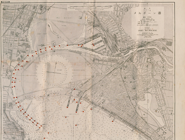 Port Melbourne Historical & Preservation Society
Map - Large map of Port Melbourne with Japanese annotation, British Chart, Port Melbourne, c 1937
Jim Sinclair was born in Cruickshank Street, Port Melbourne in 1924. During World War II Jim found this Japanese map in a network of caves near Rabaul, Papua New Guinea. He remembers '"The Japanese] had linked just about every hill with a tunnel. Concreted. Most of them were packed with stuff. I used to wander through - being very careful too, mind you!. You didn't want yourself to get blown up. I found these maps. I thought that looks familiar! It's in English with Japanese stuff on it too."A large 1937 British map of Port Melbourne with Japanese printed annotations with strategic infrastructure marked. Used during World War II. Stamp on back explains age in Japanese. war - world war ii, port of melbourne, jim sinclair, japanese -
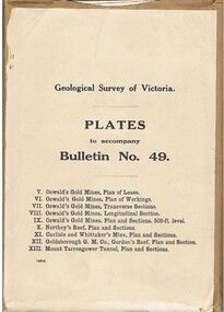 Bendigo Historical Society Inc.
Book - MCCOLL, RANKIN AND STANISTREET COLLECTION: PLATES TO ACCOMPANY BULLETIN NO.49 MALDON GEOLOGICAL SURVEY OF VICTORIA
Book; Brown paper containers with plates (& maps) to accompany bulletin No49 of geological survey of Victoria. V Oswalds G.M. Plan of lease. VI. Oswalds G. M. Plan of workings. VII. Oswalds G. M. Transverse Sect. VIII. Oswalds G. M. Longit. Section. IX. Oswalds G. M. Plan & Sect. 500ft. Level. X. Northey's Reef plan & sections. XI. Carlisle and Whittaker's Mine Plan & Sections.XII. Goldsborough G. M. Co. Gordon's Reef, Plan & Section. XIII. Mount Tarrengower Tunnel Plan & Section.MCCOLL RANKIN & STANISTREETorganisation, industry, surveys, mccoll rankin & stanistreet -
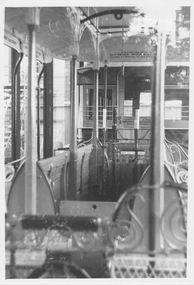 Melbourne Tram Museum
Photograph - Cable tram gripman's compartment with levers, K McCarthy
Photograph shows part of the preserved cable grip car number 1 and trailer car number 1 in a large glass covered display case in Russell Street behind the (then) Melbourne Museum and State Library. The photograph shows the gripman's compartment with two brake levers and the central grip lever. At the top of the photo above the levers is curved metal beam to which a block and tackle were fastened to lift and lower the grip into the tunnel. At either end of the compartment is a knee high board with whole at the top that fitted into slots between the end traverse seats to stop winter drafts blowing across the gripman's feet. Yields information about cable tram componentsBlack and white photograph with note on rearIn ink "29" and "K McC"cable trams, russell street, melbourne museum, state library, draw bar, tie rod, pin, safety chain, trailer coupling -
 Bendigo Historical Society Inc.
Book - JOSEPH BRADY COLLECTION: NOTEBOOK, BENDIGO WATER WORKS - CRUSOE RESERVOIR AND OTHER CONTRACTS 1870 TO 1874
Dark green covered book with gold edging front and back and seven horizontal lines on the spine. On front cover: buff sticker, with Bendigo Water Works, Crusoe Reservoir and others, contracts 1870 - 1874 written in cursive script. Later writing 'from Mrs. H. Strickland, Bungoona, Currie, King Island'. Written inside is: Presented to Bendigo Historical Society by Mrs A Strickland, Bungoona, Currie, King Island. Also the Historical Society Stamp. The next page has three newspaper cuttings. The first is 'The Victorian Waterworks'. It has costings for contracts for water supply, amounts which will supply water from the Coliban to the Castlemaine and Sandhurst districts, and if the Government should purchase the Bendigo Waterworks, and to construct the Upper Coliban reservoir, additional expenditure may be required. (from Daily Telegraph - 1868). The second is some information on The Yan Yean Aqueduct. The third is a letter to the Editor of the Argus from Joseph Brady, dated August 2, 1870, in reference to repairing the leak in the outlet tunnel of the Malmsbury Reservoir. He says the repair of the tunnel was not essential and is unnecessary and 2nd. If the bank was cut through and restored, for years the bank would not be safe, as the earth used in the restoration would require time to subside and unite with the old work. He hopes the embankment would be allowed to stand intact.civil engineering, water supply, coliban, bendigo water works - crusoe reservoir and other contracts 1870 to 1874, mrs a strictland, royal historical society of victoria bendigo branch, coliban scheme, upper coliban reservoir, daily telegraph 1868, yan yean aqueduct, age, argus 2/8/1870, malmsbury reservoir, joseph brady, charles cook, fishburn morton & kennedy, bernard ward & co, the fulton foundry co ltd, james mcewan & co, laylands foundry co, melbourne sewers & water supply, c w gore, crusoe office, john mcilwraith, edward chandler, ia-s miller & co, robison br & co, guthrie/white hills pottery, peter mcpherson, slater & co, john danks, mclean br & rigg, william beebe, t i connelly, i horwoods -
 Federation University Historical Collection
Book, Railway Practice: a collection of working plans and practical details of construction in the public works of the most celebrated engineers, 1847 (exact)
A green cloth hard cover book. Title and author's name are engraved in gold on spine. This is the 3rd edition, first series with black and white illustrations. It describes the engineering practices of the early days of British railroads. The book includes (series 1 to 4)and it contains, roads, tramroads and railroads, bridges, aqueducts, viaducts, wharfs, warehouses, roofs, and sheds, canals, locks, sluices, & the various works on rivers, streams, etc., harbours, docks, piers and jetties, tunnels, cuttings and embankments, the several works connected with the drainage of marshes, marine sands, and the irrigation of land, water-works, gas-works, water-wheels, mills, engines.civil engineering, railway practice, rail constructions, s c brees, western railway great britain, public works, railroads, canals, s.c. brees, samuel brees, samuel charles brees -
 Melbourne Tram Museum
Document - Report, Melbourne & Metropolitan Tramways Board (MMTB), "A discussion on fundamental aspects of underground tram operations that are of importance for the preliminary design', Jul. 1966
Report - Foolscap 21 typed pages, 18 bound sheets of diagrams and 1 loose diagram, with card covers, with red binding strips, titled "A discussion on fundamental aspects of underground tram operations that are of importance for the preliminary design', dated July 1966. Looks at the design aspects, tunnel sections, size, passenger access (all stairs), direction of operation - allowed for reversal of running, curvature, turnouts and cross overs, gradients, storage sidings, freight, ventilation and emergency uses. A loose sheet of a doubled deck Liverpool tram. Vehicles modelled included double deck buses and suburban trains including W class trams.In top left hand corner "Lees" in penciltrams, tramways, trackwork, melbourne, underground tramways, crossover -
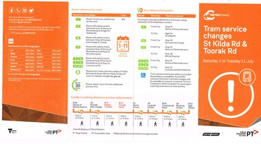 Melbourne Tram Museum
Pamphlet, Public Transport Victoria (PTV), "Tram service changes St Kilda Rd & Toorak Rd", Jun. 2017
.1 - Pamphlet - four fold - DL side four colour printed on off-white paper, titled "Tram service changes St Kilda Rd & Toorak Rd", advising intending passengers of the work between 1/7/2017 and 11/7/2017 to connect route 8 at Toorak Road West into St Kilda road the closure of the route via Park and Domain Road. Has a map, list of service changes, bus replacement guides and contact information. Has the logos of Metro Tunnel, Yarra Trams and PTV. .2 Pamphlet, printed and cut for use in trams around passenger hanging rails, titled "St Kilda Rd Tram and Bus service changes - Saturday 1 to Tuesday 11 July" - details bus replacement services and tram stops. Related to the main pamphlet - see image Set of five digital images taken at stop 25, Park St advising of the route diversion, replacement services and stop closure and two protest posters on fences nearby the stop about the Metro Tunnel project trucks using the local streets and the closure of the Park St / Domain Road tram line. .2 Pamphlet, printed and cut for use in trams around passenger hanging rails, titled "St Kilda Rd Tram and Bus service changes - Saturday 1 to Tuesday 11 July" - details bus replacement services and tram stops. Related to the main pamphlet.trams, tramways, park st, domain junction, metro tunnel, toorak rd, st kilda rd, tramway construction -
 Kiewa Valley Historical Society
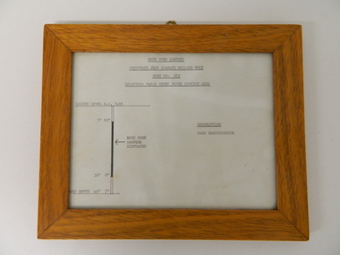
Sketch Rock Core Display, circa mid to late 1900's
This framed sketch details, in graphic form, where the core samples in the display cabinet were removed. The drilling was a precursor to the decision where to locate, in this case, the McKay Creek Power Station. The information gained by structural engineers from the core samples would be used also for the placements of underground tunnels entry and exit points and the overall effective size of the plant. This would have included drill and blast techniques(rock characteristics play an import part of explosion control), requirements for support structures and reinforcing cement/steel forms. The use and replenishment of diamond drill bits(the strongest available, see KVHS 0280) was dependent on the "type" of rock found. Support beams for reinforced ceilings and floors was also a necessity.The visual derails of where the rock core samples were removed is very significant in the formulation and placement of the underground Power Stations and their maze of tunnels(in and out) for a successful implementation of the Hydro Scheme. The amount of pre-planning and scientific studies required for such a large scheme must be undertaken to ensure that a "white elephant" was not the result.This framed and glass front rock core display sketch has type written information of the rock samples displayed in KVHS 0279 (A). It has a softwood stained and glossed frame with a fixed(nailed) back board and a brass fixture for mounting onto a wall.The paper and type are slighted faded (sunlight affected). The sign heading "ROCK CORE SAMPLES RECOVERED FROM DIAMOND DRILLED BORE" underneath this "BORE NO: 883" and below this "LOCATION: McKAY CREEK POWER STATION AREA" to the left a sketch incorporating the ground level point "GROUND LEVEL R.L.3493", and the core depth point "CORE DEPTH 40' 7". In between and representing( in visual form) the core location areain question.alternate energy supplies, alpine feasibility studies temperature, rainfall, sec, kiewa hydro scheme, electricity -
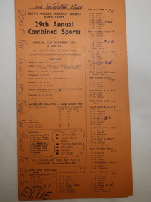 Kiewa Valley Historical Society
Programme - 29th Annual Combined Sports 1971, Kiewa Valley Schools' Sports Association
Combined school athletic sports were held annually. This one was between 11 teams: Mt. Beauty Black, Tawonga Purple, Mt Beauty Gold, Dederang, Mt Beauty Blue, Tawonga South, Mt Beauty Green, Bogong, Kancoona and Kergunyah South. Events included High Jump, Long Jump for Boys and Girls and Triple Jump for Boys. Also, Potato Race, Zig Zag team of 6, and Bounce Ball. Flat Races boys and girls. Championship for Boys and Girls Under and Over 10 years.Relay Team Open, Skip Ball Open. Tunnel Ball Open,.Circle Gap Open and a Boys and Girls Circle Gap 220 yards.Primary Schools from the Kiewa Valley held athletic sports each year. The schools consisted of small and big schools in the Kiewa Valley. The events included running and jumping as well as team 'fun/novelty' events.Events were run according to age and differed between boys and girls.Orange cardboard athletic sports programme folded in half with 69 events listed with "Officials" named and children's names or teams listed. "Don't you Think It's True You Ought To Be in Blue" penned on the front. "Good Old Blue. Blue Forever. We stick to First Place." "Blue is the Best" "No Sweat to Blue" penned on the fold in the middle. "Good Old Blue" and "Blue" penned on the back.athletics., athletics sports day, school sports, kiewa valley sports -
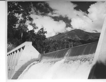 Kiewa Valley Historical Society
Photograph of Lake Guy Dam, Spillway, Lake Guy Dam, c1945
In December 1939 the excavation of the diversion tunnel at the site of Junction (Lake Guy) Dam was commenced and finished in February, 1940.This allowed the stream to be diverted to facilitate the dam wall construction. This is a 'slab and buttress' dam. It is framed with timber and concrete then poured into the structure. A contract was let to Lewis Construction Co. for the construction of the dam, and the first batch of concrete was placed in September, 1940. Industrial trouble caused some delays but there was also slow progress on the part of the contractor and the work was taken over by the S.E.C., terminating the contract. The dam was completed in March, 1944. The lake is named after Mr. L.T. Guy who was the Resident Engineer, in charge of construction work and associated activities on the Kiewa area, from 1939 until November 1946. An historical pictorial record taken for the State Electricity Commission of Junction Dam (Lake Guy) on spill. Mt. Arthur is in the background and there is still evidence of the destruction of trees from the 1939 bushfires. Black and white photograph of Lake Guy Dam . The dam is spilling and Mt. Arthur is in the background. Hand written on back of photograph in blue ink " Lake Guy Dam".dam, lake, water, mr. l.t.guy