Showing 10533 items
matching lander
-
 Kiewa Valley Historical Society
Papers - Hollonds' Family and their memories, 2013
The Hollonds' family were original settlers in the Kiewa Valley at Mulagong. Their descendants owned land in Tawonga, Tawonga South and between the East and West of the Kiewa river. Hollonds had a cattle run on Mt Fainter which was later given to the Hicks family.Members of the Hollonds family lived, worked and married in the Kiewa Valley. These papers describe the connection to the families and the Kiewa Valley.Typed papers donated by the Hollonds' family covering: The Hollonds Family History, Cattlemen, 'Snowy' Miller, Mrs Hollonds' Boarding house, SEC Depot at Tawonga, building of Bogong Township, Early Scenes on the Kiewa Scheme.hollonds family, tawonga station, cattlemen, mt beauty land, tawonga boarding house -
 Kiewa Valley Historical Society
Papers - Jim Goonan's Story - Dederang, 1950's
Early settlers came to Dederang from Kergunyah. The main road, Dederang to Tawonga was opened about 1860 - 1864, connecting 'Crosthwaite's Gap' with 'Smith's corner'. Jim Goonan's ancestors selected land between Dederang and Tawonga in the early 1860's.A comprehensive history of the town of Dederang from the 1860's up to the 1950's. Early settlers, infrastructure, businesses, activities including sport and life style are described giving an insight into how the Kiewa Valley developed during this time.26 typed pages of the History of Dederang. Each page consists of paragraphs with a heading.dederang, jim goonan, kiewa valley -
![Newspaper Clipping - Digital Image, Switch of track site riles dads 1973 [Willinda Park], 21/08/1973](/media/collectors/4f729f5697f83e03086015b8/items/5eb3d80521ea670b94305a93/item-media/5eb3d84821ea670b94308ecf/item-fit-380x285.jpg) Greensborough Historical Society
Greensborough Historical SocietyNewspaper Clipping - Digital Image, Switch of track site riles dads 1973 [Willinda Park], 21/08/1973
In 1973, parents of children in Diamond Valley Little Athletics were angered at the suggestion that the proposed all weather track at Willinda Park be scrapped. There was some talk of acquiring "Partington land" between the rail line and Plenty River, south of Church Street. News clipping, black and white text. 3 scans.diamond valley little athletics association, willinda park, partington family -
 Greensborough Historical Society
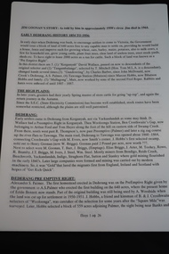
Document - Correspondence - Letter, Marsh to Partington 1943, 16/04/1943
This letter is to Mrs Annie May Partington from solicitors representing Mr Richard Marsh, regarding the use of a log to cross the Plenty River. Partingtons used this log to access the town from their home. Mr Marsh is claiming this is trespass on his land.Legal document regarding a conflict between neighbours.Double sided, typed letter. On buff letterhead from solicitor's office.Typed letter.marsh, partington, plenty river, green dobson and middleton, tresspass -
 Greensborough Historical Society
Paper bag, Medhurst Wines, Yarra Valley, 2016_
This bag was obtained from Medhurst Wines, Yarra Valley, as a gift for Faye Fort, who is a descendant of the Medhurst family. The Medhurst family moved to Gruyere in the Yarra Valley in 1855. They farmed the land that is now the vineyard that bears their name. In 1898 they moved to Greensborough.Brown paper bag with company logo."Medhurst Wines Yarra Valley"medhurst family, medhurst wines yarra valley -
 Orbost & District Historical Society
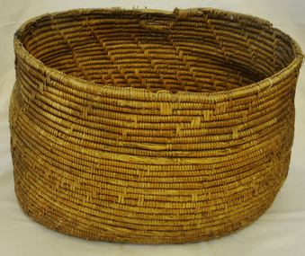
basket, Untitled, second half 19th century
Made as wedding present for Cameron, John (Mrs) in 1880 at Lakes Entrance. John Cameron (1847-1930) selected first land on Snowy River flats. Married Elizabeth Roadknight (1863-1939) who was born in Cunninghame (now Lakes Entrance).This item is associated with the Cameron family who were early Orbost settlers.Large handmade woven Aboriginal basket.basket household basket-woven aboriginal lakes-entrance cameron-john -
 City of Moorabbin Historical Society (Operating the Box Cottage Museum)
Document - Reflections - Bentleigh Baptist Church Diary
The Baptist Church was built in 1881 in Tucker Road, in 1916 on land donated by Henry Box, a local market gardener. The wooden Church was moved to the to Vickery Street Bentleigh, the current site of the Bentleigh Baptist Church . The removal was made on a horse drawn jinker.The Baptist Church was integral to the spiritual well being and social life of the early settlers.22 Page typed document which outlines the history of the Baptist Church, Bentleigh.early settlers, parish of moorabbin, city of moorabbin, county of bourke, shire of moorabbin, market gardeners, baptist church bentleigh, vickery street, religion, bentleigh -
 Bendigo Historical Society Inc.
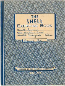
Document - M. Symons' Murpheys Creek Exercise Book
Land was first selected at Murphy's Flat in 1865. The first Wesleyan church was built in 1866 and from 1869 this was used as State School 149. A purpose built school, No. 1311 opened mid 1876. The areas name was changed to Murphy's Creek in 1915.A blue and white exercise book. Attached within are various subscription receipts in the front and back, including the "Australian Home Journal," "Singer Sewing Machine Company," and an "Annual Audit of Depositors' Pass-books by the State Savings Bank of Australia. Also included in approximately half the book are handwritten record of correspondence notes in blue ink, many regarding sewing from 1949-1956.The Shell Exercise Book. Name: M. Symons (Handwritten Blue Ink). Grade: Murphys Creek. School: Via, Tarnagulla, Victoria (Handwritten Blue Ink). Receipts, Etc.(Handwritten Blue Ink), Approved by the Education Department. Shell Series. On the back is printed Arithmetic Tables and a Multiplication Tableexercise book, receipts, tarnagulla -
 Moorabbin Air Museum
Document (Item) - Two Years In The Aviation Hall Of Doom
Description: Date: 16/7/2007 Author: Hon. Kim Beazley Publisher: Land Warfare Studies Centre Pages: 12 Binding: Loose Leaf - Envelope Keywords: Speech to 2007 Sir Vernon Sturdee Symposium Level of Importance: National. -
 St Kilda Historical Society
Photograph, St Kilda Landing 1927, Duke and Duchess of York, c. 1927
View looking down on Ladies and Men's Baths, beach front and Pierrot land. A newspaper clipping stuck on the back:Duke of York's Wide Popularity. Marriage of Romance. Australian Visit Memories. The article contains mainly biographical information. Photograph of Duke and Duchessblack and white photographPhotograph mounted on cardboard -
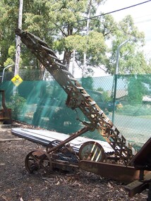 Puffing Billy Railway
Machine - Conveyor / Loader, Munro Engineers Pty Ltd, 1955
Munro Engineers Pty Ltd, Handilift Stacker & Loader' The Land on which the Menzies Creek railway station and Museum are built on was once apart of James Hermon's & his son William Hermon's property on which this Munro Handilift Stacker & Loader was used. Historic -Industrial Tool - Handilift Stacker & Loader - used on Jame's Hermon's property on which the Menzies Creek Railway is built on Munro Engineers Pty Ltd, Handilift Stacker & Loader made of steel and wood and wrought ironMunro Engineers Pty ( symbol map of Australia ) Ltd, Ballarat Vic. On side - No. 3147 On wheel - no, 2052puffing billy, munro engineers, handilift stacker & loader, hermon, menzies creek -
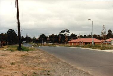 Hume City Civic Collection
Photograph, early 1990s
The series of 5 photographs feature different views of the Woodlands Housing Development which opened up land bounded by Gap and Anderson Roads, Cornish Street and Elizabeth Drive in the early 1990s. It was a large housing development built close to Sunbury township.A coloured photograph of one of the last housing developments which took place in the old township area. It is a photograph taken at the north end of Anderson Road looking towards Gap Road. One house has been built and there are a number of 'For Sale' signs of blocks fronting Anderson Road. Guttering and driveways have been formed on one side of the road.housing developments, anderson road, george evans collection -
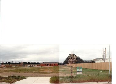
 Hume City Civic Collection
Photograph, early 1990s
The series of 5 photographs feature different views of the Woodlands housing development which opened up land bounded by Gap and Anderson Roads, Cornish Street and Elizabeth Drive in the early 1990s. It was a large housing development built close to Sunbury township.A view of the northern boundary of the Woodlands housing development in Anderson Road. A paling fence divides the estate from the 'Malley' factory, now 'Storage King' which is on the corner of Cornish Street and Anderson Road. A 'For Sale' sign is in the foreground and a partly built house is in the middle distance.housing developments, anderson road, george evans collection -
 Hume City Civic Collection
Photograph, early 1990s
The series of 5 photographs feature different views of the Woodlands housing development which opened up land bounded by Gap and Anderson Roads, Cornish Street and Elizabeth Drive in the early 1990s. It was a large housing development built close to Sunbury township.A coloured photograph of a new housing development taken in Anderson Road looking west towards Elizabeth Drive and the leisure centre. Some housing construction is in the middle distance.housing developments, anderson road, george evans collection -
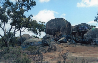 Stawell Historical Society Inc
Photograph, Sister Rocks 2011-- Coloured photograph looking South
Colour Photograph Taken c 2011 Sister Rocks Stawell This photo is of a well known land mark along the Western Highway. They take their name from 3 sisters named Levy, who camped there with their parents during the early days of Stawell.Colour Photograph of Sister Rocks looking South c 2011South Taken c 2011stawell tourism -
 Torquay and District Historical Society
Photo (copy), Bellbrae Cemetery Memorial Exhibition
Joseph Gundry was born at Lopen ,Somerset England circa 1810.He arrived in Van Dieman's Land 1832from England ,followed by his brothers,William 1837,and Charles later .Joseph died a Jan Juc in 1878 and is buried it the Bellbrae Cemetery .Black and white photograph of Joseph Gundry -
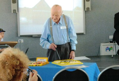 Whitehorse Historical Society Inc.
Photograph, Jack King, 2011
As the oldest living student of the Burwood East Primary School, Jack King cut the pioneering cake. The King family was one of the pioneering East Burwood families whose land was where the present East Burwood Basketball Stadium and football Club sit.2 coloured photograph (a -b) of Jack King at the 150th anniversary of the Burwood East Primary School.king, jack, burwood east primary school -
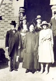 Whitehorse Historical Society Inc.
Photograph, Wakefield family
John Wakefield Snr. migrated to Australia in 1852, as a crewman. Elizabeth, John, Tom and George arrived in 1854. In 1859 John Wakefield Jnr. married Rhoda Hartnett. They purchased land and a cottage on the Springfield Village Estate, Springfield Road, Blackburn North.Sepia photograph of a group of six people at a wedding. John and Rhoda Wakefield are at front - left and centre.wakefield, john, rhoda, wakefield family -
Lakes Entrance Regional Historical Society (operating as Lakes Entrance History Centre & Museum)
Photograph
Colonel Windridge was in charge of the Native Police in Melbourne in 1840. He was sent by Gov. Latrobe to make a road b/w Melbourne and Port Albert . On 8.3.1946 he named Lake Tyers after CJ Tyers Crown Land Commissioner for GippslandColour photocopy of original painting of Colonel Windridgetransport, tourism -
Southern Sherbrooke Historical Society Inc.
Map - photocopy, Woodcock & McCormack, civil engineers & architects & surveyors, The Major Estate, Belgrave
A photocopy taken from the original land sale map provided to the society through Karel Coxell of Stockdale & Leggo. The original maps are stored in large bound account books and were originally the propert of McNally Real Estate. The books are held (in 22 A3 sheets. Shows The Serpentine between Government Rd (now Sandells Rd) and Government Rd(now Terrys Ave), Belgrave. Arrows to Belgrave, Sherbrooke Falls, Main Rd and store.land sales, advertisement, real estate subdivision, t. mahoney -
Southern Sherbrooke Historical Society Inc.
Map - photocopy
A photocopy taken from the original land sale map provided to the society through Karel Coxell of Stockdale & Leggo. The original maps are stored in large bound account books and were originally the propert of McNally Real Estate. The books are held (in 2A3 photocopy of plan of survey of part of Crown Allotments 20 & 21, section C, parish of Narre Worran, County of Mornington. Clements Ave and environs in Belgrave Heights"Villette Estate" in top LH corner, "Locality Plan" in bottom LH corner, "Not in sale" written on one block and crossed out. All handwritten in pencil on original. "Colby Drive " and "Verona Street" added in pencil to copy.land sales, advertisements, subdivision -
 Bayside Gallery - Bayside City Council Art & Heritage Collection
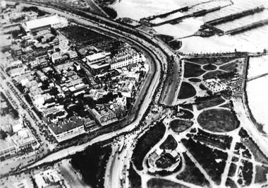
Photograph, Department of Crown Lands and Survey, Victoria, Brighton, Brighton East and Bentleigh, c. 1965-71
The Department of Crown Lands and Survey (1857-1983) was responsible for the administration of survey and mapping and the sale, occupation and management of crown land throughout its existence. This aerial photograph shows parts of Brighton, Brighton East and Bentleigh and was taken circa 1965-71.brighton, department of crown lands and survey, aerial photograph, bayside, port phillip bay, map, cartographic material, bentleigh, brighton east, dendy park, dendy street, centre road, nepean highway, south road, football -
 Kew Historical Society Inc
Plan - Subdivision Plan, Six Big Home Sites, Camberwell North, c.1936
Subdivision plans are historically important documents used as evidence of the growth of suburbs in Australia. They frequently provide information about when the land was sold on which a built structure was subsequently constructed as well as evidence relating to surveyors and real estate and financial agents. The numerous subdivision plans in the Kew Historical Society's collection represent working documents, ranging from the initial sketches made in planning a subdivision to printed plans on which auctioneers or agents listed the prices for which individual lots were sold. In a number of cases, the reverse of a subdivision plan in the collection includes a photograph of a house that was also for sale by the agent. These photographs provide significant heritage information relating house design and decoration, fencing and household gardens.A subdivision in what is currently Balwyn, but which was advertised as being in Camberwell North. The subdivision included six allotments facing Buchanan Avenue and Houghton Street. The subdivision was to the east of the Pointed Firs Estate (1936). In addition to the intrinsic value of this subdivision plan, it also reveals information about the development of transport infrastructure in this area. The subdivision plan notes that the Tramways Board has approved the extension of the tram route past the current terminus at Balwyn Road.subdivision plans - camberwell -
 Kew Historical Society Inc
Plan - Subdivision Plan, Windella-Darnley Subdivision, Studley Park, 1920s
Subdivision plans are historically important documents used as evidence of the growth of suburbs in Australia. They frequently provide information about when the land was sold on which a built structure was subsequently constructed as well as evidence relating to surveyors and real estate and financial agents. The numerous subdivision plans in the Kew Historical Society's collection represent working documents, ranging from the initial sketches made in planning a subdivision to printed plans on which auctioneers or agents listed the prices for which individual lots were sold. In a number of cases, the reverse of a subdivision plan in the collection includes a photograph of a house that was also for sale by the agent. These photographs provide significant heritage information relating house design and decoration, fencing and household gardens.Version 1 of two subdivision plans (the later one is MAP.0027) for the section of Studley Park Road near the Junction on the south side. Named in the subdivision are the mansions of Darley and Windella (now demolished). Before the subdivision of Darley and Windella, both houses fronted Studley Park Road. Both houses appear to be advertised as lots in the subdivision. Bisecting the subdivision is a street, Antrim Avenue that was never constructed. A street, which was subsequently constructed in this vicinity, was Merrion Place, which now runs between Studley Park Road and Highfield Grove. There are 14 proposed lots in this subdivision."Antrim Avenue. See over for new plan"subdivision plans - kew, studley park, windella, darnley, studley park road -- kew (vic.), merrion place -- kew (vic.), merrion grove -- kew (vic.), highbury grove -- kew (vic.) -
 Kew Historical Society Inc
Plan - Subdivision Plan, Shop Sites, East Kew, c.1927
Subdivision plans are historically important documents used as evidence of the growth of suburbs in Australia. They frequently provide information about when the land was sold on which a built structure was subsequently constructed as well as evidence relating to surveyors and real estate and financial agents. The numerous subdivision plans in the Kew Historical Society's collection represent working documents, ranging from the initial sketches made in planning a subdivision to printed plans on which auctioneers or agents listed the prices for which individual lots were sold. In a number of cases, the reverse of a subdivision plan in the collection includes a photograph of a house that was also for sale by the agent. These photographs provide significant heritage information relating house design and decoration, fencing and household gardens.This is one of a small number of subdivision plans for commercial property in the collection. The subdivision proposed to create six shop sites in High Street between the Harp of Erin and Station Street. The plan shows this stretch of High Street, East Kew already lined with shops that include the hotel on the corner, the new State Savings Bank, a dentist’s surgery and Lambert’s Store. The High Street Tram was to reach Burke Road in 1925, so the proposed subdivision must postdate that event, and the opening of the Bank in 1926.subdivision plans - east kew, high street - east kew -
 Kew Historical Society Inc
Plan - Subdivision Plan, Eastlawn Estate, 1914
Subdivision plans are historically important documents used as evidence of the growth of suburbs in Australia. They frequently provide information about when the land was sold on which a built structure was subsequently constructed as well as evidence relating to surveyors and real estate and financial agents. The numerous subdivision plans in the Kew Historical Society's collection represent working documents, ranging from the initial sketches made in planning a subdivision to printed plans on which auctioneers or agents listed the prices for which individual lots were sold. In a number of cases, the reverse of a subdivision plan in the collection includes a photograph of a house that was also for sale by the agent. These photographs provide significant heritage information relating house design and decoration, fencing and household gardens.The ‘Eastlawn Estate’ was surveyed and ready for auction in March 1914, three months before the outbreak of World War I. Sixty-six allotments, created on the ‘order of Mr & Miss Preston’ surrounded the mansion of Woodlands in Harp Road. Woodlands formed part of the Estate, being advertised as lot 1. The allotments faced High, Station and Wright Streets, Harp and Normanby Roads, and Woodlands Avenue. Pru Sanderson in the Kew Conservation Study (Vol.2, 1988) wrote that the Eastlawn Estate ‘covered the western half of the failed Harp of Erin Estate’. Contemporary advertisements promoted the Eastlawn Estate as: ‘There will be no more convenient district nor pleasant Suburb than East Kew for the busy business man. When the Electric Tram is laid, he will be able to journey quickly and pleasantly direct from Collins Street to his home in the Eastlawn Estate in about 20 minutes’. The actual plans of subdivision were included in advertisements in The Argus and in the local newspapers.subdivision plans - east kew, eastlawn estate -
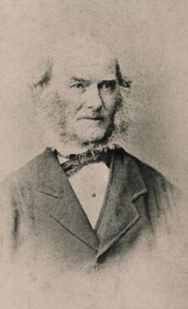
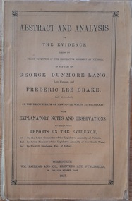 Hymettus Cottage & Garden Ballarat
Work on paper - Book, Abstract and Analysis of the Evidence taken by A Select Committee of the Assembly of Victoria in the Case of George Dunmore Lang Late Manager and Frederic Lee Drake Late Assistant of the Bank of New South Wales at Ballaarat
Rev John Dunmore Lang's defence of his son who was imprisoned for his part in the fraud at the Bank of New South Wales Ballarat and Clunes in 1854.Small 95 page booklet published in 1857 by Fairfax, Melbourne and inscribed by W. D. Lang.non-fictionRev John Dunmore Lang's defence of his son who was imprisoned for his part in the fraud at the Bank of New South Wales Ballarat and Clunes in 1854.drake, lang, rev john dunmore lang, ballarat, clunes, select committee of enquiry -
 The Beechworth Burke Museum
Photograph, c1865
This was taken in 1865 of Spring Creek, Beechworth. Gold was discovered in this area in 1852 and within eleven months of this discovery, over 8000 hopeful prospectors had descended on the region, transforming the seemingly undisturbed land into what a visiting journalist in 1880s referred to as; "A Titan's Field". Huge mounds of earth were churned by hundreds of miners in search for gold, almost every available resource the land had to offer was used for something; even the bark off the gums were stripped to line huts and shafts. By 1857 more than 20,000 people lived in Beechworth, and with this influx the town prospered with the building of numerous churches, banks, schools, shops and hotels along with a prison and hospital.Black and white rectangular photograph. Image is printed on matte photographic paper and is mounted on cardboard. Obverse: NO INSCRIPTION Revese: 97.22.95 / 7772 / 25/1 / beechworth, burke museum, gold rush, 1865 -
 Warrnambool and District Historical Society Inc.
Plates, Rolfe Saucers x 6, 1864
These saucers are part of a crockery set that belonged to George Rolfe and his family. George Rolfe (1836-1919) was a tea merchant in Melbourne who bought land at the mouth of the Hopkins River in Warrnambool in the 1880s. He had adjoining land and the properties of ‘Shipley’ and ‘Fairy Hill’ and developed ‘Lyndoch’, adding stables, jetty, boat house, windmill and reservoir, chaff and bone sheds and an extensive garden. In 1891 he married Annie Lake and it was his stepdaughter, Florence Lake who built the ‘Lyndoch’ house still standing today. ‘Lyndoch’ today is now the site of an Aged Care Facility. This item is part of the Rolfe Dinnerset as described on Victorian Collections at VC001420 and VC001422.These saucers, part of a crockery set, are kept because they belonged to George Rolfe, a prominent property owner and farmer in Warrnambool in the late 19th century and early 20th century. The items, dating from 1864, have social significance showing the type of crockery used by a more affluent family in the 19th century. These are six circular china saucers with a gold rim and ornamentation in a scallop design in gold and teal around the rim and the outer edges. The base of the saucers has a gold rim. One of the saucers has a chip on the edge and four show significant wearing of the inner gold circle. Some of the outside gold edging also shows wear. The maker’s marks and name are indented on the bottom of the saucers ‘Minton’ lyndoch, warrnambool, rolfe and co., george rolfe, history of warrnambool, florence lake -
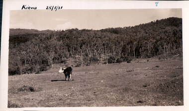 Kiewa Valley Historical Society
Black and white photograph of farmland, Kiewa, 25/8/38, circa 1938
This photograph was taken in August, 1938, some eight years prior to the establishment of Mt. Beauty a a township. The area was still being used for grazing, and the land was eventually acquired from the local land owners by the State Electricity Commission. The construction of the road, from Tawonga to the High Plains, was commenced in April, 1938 and this photograph was taken August, 1938. This allowed men and heavy equipment to be transported to the work sites for the construction of the Kiewa Hydro Electric Scheme. Prior to this access was by bridle trail, either on horse back or on foot. By 1946 housing construction had commenced for the new town of Mt. Beauty and by 1948 street construction in the southern part of the town was completed as far as Hill Street.This photograph is important as it shows the upper Kiewa Valley as it was before the establishment of the town of Mt. Beauty. The land has been cleared of natural vegetation to allow grazing of cattle. Black and white photograph of grazing farmland with one animal standing in the paddock. The area could possibly be where the golf course now stands with the road to the high plains not yet commenced.Handwritten in the upper left hand corner 'Kiewa 25/8/38'. The number 7 has been stamped in the upper right hand corner. It is part of a set of 8 photographs. On the back are the words Velox repeated several times, indicating the type of photographic papergrazing, kiewa, mt. beauty, secv