Showing 3906 items matching "bricker"
-
 Kew Historical Society Inc
Plan, Melbourne & Metropolitan Board of Works : Borough of Kew : Detail Plan No.1578, 1904
The Melbourne and Metropolitan Board of Works (MMBW) plans were produced from the 1890s to the 1950s. They were crucial to the design and development of Melbourne's sewerage and drainage system. The plans, at a scale of 40 feet to 1 inch (1:480), provide a detailed historical record of Melbourne streetscapes and environmental features. Each plan covers one or two street blocks (roughly six streets), showing details of buildings, including garden layouts and ownership boundaries, and features such as laneways, drains, bridges, parks, municipal boundaries and other prominent landmarks as they existed at the time each plan was produced. (Source: State Library of Victoria). This plan forms part of a large group of MMBW plans and maps that was donated to the Society by the Mr Poulter, City Engineer of the City of Kew in 1989. Within this collection, thirty-five hand-coloured plans, backed with linen, are of statewide significance as they include annotations that provide details of construction materials used in buildings in the first decade of the 20th century as well as additional information about land ownership and usage. The copies in the Public Record Office Victoria and the State Library of Victoria are monochrome versions which do not denote building materials so that the maps in this collection are invaluable and unique tools for researchers and heritage consultants. A number of the plans are not held in the collection of the State Library of Victoria so they have the additional attribute of rarity.Original survey plan, issued by the MMBW to a contractor with responsibility for constructing sewers in the area identified on the plan within the Borough of Kew. The plan was at some stage hand-coloured, possibly by the contractor, but more likely by officers working in the Engineering Department of the Borough and later Town, then City of Kew. The hand-coloured sections of buildings on the plan were used to denote masonry or brick constructions (pink), weatherboard constructions (yellow), and public buildings (grey). MMBW Plan No.1578 is significant in that it defines the extent of two private schools: Xavier College and Kew High School (now part of Trinity Grammar) by 1904. In relation to the latter, the plan clarifies which buildings the High School operated from behind the mansion ‘Molina’. Established in 1902, Trinity Grammar was to later lease and subsequently buy Molina (now ‘Merritt House’) and ‘Elsinore’ (now ‘Roberts House’). Xavier College had been established in 1872. This 1904 plan delineates the West Wing and the Great Hall (built in 1890).melbourne and metropolitan board of works, detail plans, maps - borough of kew, mmbw 1578, cartography -
 Kew Historical Society Inc
Plan, Melbourne & Metropolitan Board of Works : Borough of Kew : Detail Plan No.1590, 1905
The Melbourne and Metropolitan Board of Works (MMBW) plans were produced from the 1890s to the 1950s. They were crucial to the design and development of Melbourne's sewerage and drainage system. The plans, at a scale of 40 feet to 1 inch (1:480), provide a detailed historical record of Melbourne streetscapes and environmental features. Each plan covers one or two street blocks (roughly six streets), showing details of buildings, including garden layouts and ownership boundaries, and features such as laneways, drains, bridges, parks, municipal boundaries and other prominent landmarks as they existed at the time each plan was produced. (Source: State Library of Victoria)This plan forms part of a large group of MMBW plans and maps that was donated to the Society by the Mr Poulter, City Engineer of the City of Kew in 1989. Within this collection, thirty-five hand-coloured plans, backed with linen, are of statewide significance as they include annotations that provide details of construction materials used in buildings in the first decade of the 20th century as well as additional information about land ownership and usage. The copies in the Public Record Office Victoria and the State Library of Victoria are monochrome versions which do not denote building materials so that the maps in this collection are invaluable and unique tools for researchers and heritage consultants. A number of the plans are not held in the collection of the State Library of Victoria so they have the additional attribute of rarity.Original survey plan, issued by the MMBW to a contractor with responsibility for constructing sewers in the area identified on the plan within the Borough of Kew. The plan was at some stage hand-coloured, possibly by the contractor, but more likely by officers working in the Engineering Department of the Borough and later Town, then City of Kew. The hand-coloured sections of buildings on the plan were used to denote masonry or brick constructions (pink), weatherboard constructions (yellow), and public buildings (grey). Surveyed by the Board of Works in 1903 and published in 1904, Plan No.1590 shows development north of Cotham Road. While this plan includes built structures in Mary Street, Cotham Road, High Street, Park Hill Road, Kent Street, Ridgeway Avenue, and Ermington Lane (now Ermington Place), only part of this section was notated and coloured in this contractor’s copy. Numerous houses, large and small are named on the plan: ‘Cholula’, ‘Belper’, ‘The Uplands’, ‘Spring Grove’ facing Cotham Road; ‘Marion’ facing Kent Street; and ‘Kia Ora’ facing Ridgeway Avenue.melbourne and metropolitan board of works, detail plans, mmbw 1590, survey plans - borough of kew, cartography -
 Royal District Nursing Service (now known as Bolton Clarke)
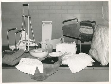
Photograph - Photograph, black and white, Barry Sutton, 1973
The equipment items in this photograph are loaned out to Royal District Nursing Service (RDNS) patient's to use in their homes. They are returned to RDNS and sterilized, or cleaned with disinfectant, whichever is appropriate, once they are no longer required. The material items are given to patient's as required. Many of these items are made and donated by RDNS Auxiliary members. From its inception in 1885, the two Trained nurses (Nurses) of the Melbourne District Nursing Society (MDNS) worked in the now CBD, ie from Spencer Street to Spring Street and from Victoria Parade to Flinders Street. At that time they walked the streets and lane ways amid the slums of inner Melbourne carrying their nursing bags containing lotion, ointments, powders, liniment, bandages, dressings, a case of spirits, and the Nurse's own clean apron, soap and small towel. They supplied equipment on loan, such as earthenware hot water bottles, splints, urinals, bed pans, bed cradles, feeding mugs, and air-cushions as well as providing blankets and clean bed linen, and nightdresses and clothes as necessary. The Society was at the forefront of health care and continued to liaise with Doctors as the Society expanded. The Nurses provided high quality nursing care to a range of people, often in destitute situations, some lying on rags on the floor as they had no bed, others with just a bed and maybe a thin blanket, a chair and nothing else. Their ages ranged from babes, children, adults to the elderly. The Nurses gave medications as ordered, dressed wounds e.g. to the injured, and surgical cases, and to those with leg ulcers; attended to patients with ‘surgical ailments’ such as ‘hip disease’; gave care to those with acute illnesses such as bronchitis, pleurisy, pneumonia, measles, and scarlet fever, as well as those with chronic illnesses such as consumption (tuberculosis), heart disease, arthritis, cancer, debility, neuritis and paralysis. They educated their patients, and their Carers, in the curing and prevention of disease; Over the years items were given and equipment was loaned and demonstrated to patients, and if appropriate, to their family members to enable them to care for their loved ones in their homes. The Trained nurses had the rehabilitation of their patients in the forefront of their minds to ensure they were able to live as independently as possible in their own homes. As the years passed the Trained nurses changed from being called 'Nurse' to 'Sister' and the Society changed its name. In the 1970s, now with Royal patronage, and known as Royal District Nursing Service ( RDNS), they contracted a Private and then employed, a Physiotherapist who taught RDNS Sisters the correct transferring techniques, including the use of a hoist when this became available. RDNS Sisters taught and used these techniques in patient’s homes to undertake safe transfer of the patient and to reduce physical strain on RDNS nursing staff and family members. Each RDNS Centre had a room or shed where equipment for loan was kept, and Headquarters also kept additional equipment which could be transported to Centres as required. This black and white photograph shows some of the equipment loaned, along with some to be given, to Royal District Nursing Service (RDNS) patients as required. Rear L-R - a white long nightdress with dark embroidery and buttons on the front and embroidery on the edge of the short sleeves. Next are two wooden bath seats; a square metal commode with lid and with its round legs extended to form handles on the left and right sides. A folded dark and white striped crocheted rug hangs over one of the handles. In the centre L-R, is a metal bed cradle, a metal 4 prong walking stick, bed pans, male urinal, stack of nappies with a white child's knitted jumper hanging over them, and a doona. In the front, L-R is a grey blanket, dark coloured bed socks, a sheepskin with a white smocked baby dress sitting on it, and a white babies nightgown on a clear plastic covered white bundle. A black mat sits under these items and a cream brick wall is in the background. Barry Sutton LS 47royal district nursing service, rdns, rdns equipment, rdns auxiliaries -
 Bacchus Marsh & District Historical Society
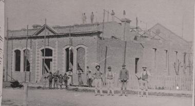
Photograph, Mechanics Institute and Hall Main Street, Bacchus Marsh 1883
A Mechanics Institute in Bacchus Marsh dates from sometime in the 1850s. The first Mechanics Institute Hall was erected in 1858 in Young Street.(Victorian Collections no.659.) In 1883 a new and larger Mechanics Institute Hall was built in Main Street. The new hall cost 2,000 pounds to construct. It was opened by Sir William Clarke on 21 November 1883. The Mechanics Institute Library and rooms at the front of the hall were removed when the building was renovated in 1971. The building still stands and is used as a public hall.Small black and white 'carte de viste' style unframed photograph on card with gold border framing photograph. Housed in the Jeremeas Family Album which contains photographs of Bacchus Marsh and District in 1883 by the photographers Stevenson and McNicoll. The photo is of a substantial brick building under construction. Scaffolding support poles line the front and also can be seen on the top and back of the building. On the rooftop stand three workmen, with a further seven men standing at the front. Three men lean or stand casually at the front in casual poses. Four men stand in a line in another group on the roadway, perhaps indicating that they are master craftsmen. One of these men holds a tool of his trade, resembling a bricklayer’s mortar board. Six boys can be seen, four in a rather jaunty pose. In an indication of its public significance, the four front windows and door are arched and have decorative stone work in the side panels. A picket fence marks the boundary of the adjacent block.Printed On the front: Stevenson & McNicoll. Photo. 108 Elizabeth St. Melbourne. COPIES CAN BE OBTAINED AT ANY TIME. On the back: LIGHT & TRUTH inscribed on a banner surmounted by a representation of the rising sun. Copies of this Portrait can be had at any time by sending the Name and Post Office Money Order or Stamps for the amount of order to STEVENSON & McNICOLL LATE BENSON & STEVENSON, Photographers. 108 Elizabeth Street, MELBOURNE. stevenson and mcnicoll 1883 photographs of bacchus marsh and district, mechanics institutes, halls, bacchus marsh mechanics institute -
 Royal Australian and New Zealand College of Obstetricians & Gynaecologists (RANZCOG)
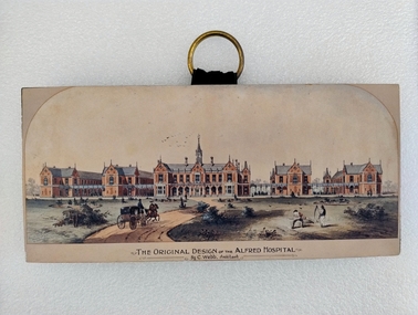
Print - Colour print, Charles Webb, Original design of the Alfred Hospital, c. 1870
"The Alfred Hospital was founded in 1869 as a result of the work of a number of Melbourne doctors who fought a long and internecine battle for an additional general hospital treating its first patient in 1871. Prahran Council donated a parcel of low lying land for the provision of a Hospital. In 1870, the Melbourne architect, Charles Webb, won the competition to design The Alfred Hospital with his revolutionary design. Webb incorporated the "Nightingale" design principles by designing large light filled pavilions as wards connected by covered corridors or walkways." (Alfred Health)Small colour print mounted on a wood block. Print depicts a series of five red brick buildings at centre, with a dirt road snaking up from the left foreground to the front of the central building. A man is driving a two horse buggy along the dirt road towards the buildings. The landscape on either side of the road consists of grassland and low vegetation, as well as four shallow circular pits (two on either side) which contain vegetation. There are two figures in the right foreground cutting grass with scythes. A flock of birds is visible in the sky in the central background, above the main hospital building. Text printed below image reads 'THE ORIGINAL DESIGN OF THE ALFRED HOSPITAL/By C.Webb, Arckitect (sic)'. The back of the wooden block to which the print is affixes is painted black, and a circular hook has been attached to the centre back of the block for hanging the artwork. The hook is gold coloured, and attached using two gold coloured pins and a small strap. Handwriting at bottom right of the back of the object reads 'ANN TAVELL''THE ORIGINAL DESIGN OF THE ALFRED HOSPITAL/By C.Webb, Arckitect (sic)' -
 Federation University Historical Collection
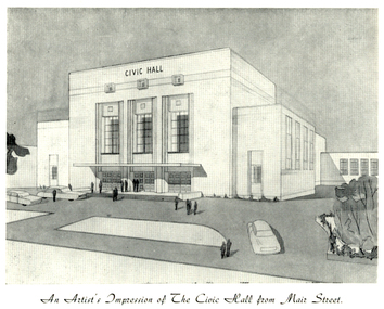
Programme, The Opening of Civic Hall, 1956, 1956
The City of Ballarat unanimously resolved to erect a Civic Hall in Mair Street in 1951. The architects, Gordon Murphy, of Melbourne, and H.L. and L.J. Coburn, of Ballarat, were commissioned in 1952. The Council constructed the foundations and footings for the building under the supervision of the former City engineer, Mr L.H. Finch, in 1953. These footings are of massed concrete. The design for the building took advantage of the cross fall of the land, providing for the Small Hall to be entered from the Doveton Street frontage through a foyer under the Main Stage, the structure is steel with brick panels, with accommodation for 1,592 persons in the Main Hall and 440 persons in the Lower Hall. The front facade faces Mair Street, set back from the building line to provide for the entrance drive-ways and kerbed gardens. Tenders were invited on a firm price basis. A young Ballarat master Builter, Walter Benbow Trahar was the successful tenderer, the contract price being 139,841 pounds. the work was commenced in 1953 and has proceeded in spite of material and labour difficulties until its completion. The following statistics are of interest:- * The foundations contained 200 cubic yards of concrete. * The constructional steel work weighs approximately 270 tons. * The reinforcing steel 47 tons. * Reinforced concrete in the structure, 1,100 cubic yards. * The approximate number of bricks in the building, 580,000. * The flooring is of selected kiln-dried hard wood and totals 40,000 lineal feet. * The dimensions of the Main Auditorium, 100ft by 86 ft, including the side promenades each 82ft by 13ft. *The Main stage, of reinforced concret with parquette finish measures 62 ft by 40ft. *The floor area of the Lower Hall is 74 ft by 38 ft, and has a stage dimensions of 40ft by 20 ft. * Each hall has independent heating and ventillating systems. Where possible the material in the building was furnished from local business houses. The public address installation, which provided for additional microphones, is on the main Stage. There is inter-communication throughout the building connecting the front office, with the bioscope box, the stages in both the large and lower halls, and the Hallkeeper's residence. Local craftsmen have completed the painting, plaster work, and the electrical installation; local produced materials being used in the construction of the buildings with the exception of the timber for the Main Floor, the roofing and the structural steel. The City of Ballarat Councillors in 1956 were Councillors N. T. Callow, F.J. Cutts, K.C. Webb, W.E. Roff, O.W. Curnow, F.T. Woodward, Allan C. Pittard, A.W. Nicholson, J.A. Chisholm, G.L. Scott, F.W. Oliver, A.D. Mason. The Town clerk was H.R. Maddern and the City Engineer was G. Murrowood. A City of Ballarat Council meeting of 25 September 2013 voted to demolish the Ballarat Civic Hall. The Council heard from nearly 50 members of the public during a marathon six-hour meeting. Councilors John Birt, Des Hudson, Amy Johnson, Josh Morris, Peter Innes, John Philips supported the motion to demolish Civic Hall. Councillors Samantha McIntosh, Vicki Coltman and Belinda Coates voted against the motion.Six page souvenir Program of citizens' entertainment on the occasion of the Opening of Ballarat Civic Hall on in August 1956. The front cover features the City of Ballarat Coat of Arms. The programme starts with a message from the Mayor, Cr Neil T. Carrow. It includes the Concert Programme directed by James H. Davey, an asrtist's impression of the Civic Hall from Mair Street, and information relative to the New Civic Hall. The programme features images of the City of Ballarat Coat of Arms, Cr N.T. Callow, , James H, Davey, and an artist's impression of the Ballarat Civic Hall. Mayor Neil Callow's Message: "To-day, our citizens witness the fulfilment of the most extensive Municipal undertaking in the City's period of recent prosperity and development. Their Hall now fills a requirement of which they have been deprived since the Coliseum building was destroyed by fire over 20 years ago. The building has been designed as an all purpose structure and I am hopeful the citizens will use it and enjoy it to its fullest extent. Your Council and its Architects have planned as broadly as possible for the benefit of all to-day and for years to come. We are proud of the work executed by a Ballaarat Master Builder whose work is a monument to the City's craftsmen. I feel I should also remind this assembly that the women of Ballaarat, back in 1951, provided funds which have been applied in the purchase of a Grand Piano and two Upright Pianos which are now installed in this building. The sincere hope of myself and your Councillors is that this Hall and its amenities will prove of immense value to the development of the cultural and artistic tastes of this community and that it will be freely used for these and many other purposes. From now on this magnificent building and its furnishings and equipment will be available to all. I strongly exhort you to use and protect it. My hope is that the citizens will, for many years to come, enjoy the amenities which it has to offer. ballarat civic hall, civic hall, architecture, finch, art deco, city of ballarat, coat of arms, city of ballarat coat of arms, callow, shugg, lemke, oates, gullan, tuuri, john, robertson, sorrell, antonio, gordon murphy, walter benbow trahar, trahar, coburn, h.l. coburn, l.j. coburn, n.t. callow -
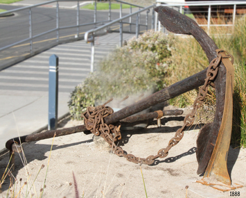 Flagstaff Hill Maritime Museum and Village
Anchor, Before 1831
Historical Information: The anchor is from the wooden sailing ship CHILDREN, which was wrecked at Childers Cove east of Warrnambool on the 15th of January 1839 with the loss of 16 lives. The Children anchor was raised from the wreck site by Flagstaff Hill Divers; Peter Ronald, Garry Hayden (Terang, still), Tim Goodall (now Warrnambool), and Colin Goodall (now Warrnambool), on Sunday 3rd January 1974. A week or so later it was dragged up the cliffs and taken to Warrnambool. It is now on display near the entrance to the Maritime Village and Museum. It appears to be a Pering’s Improved Anchor, developed at Portsmouth after 1813. The addition of broad curvature to the anchor arms provided a stronger purchase than the pre-existing Admiralty Old Pattern Long Shanked Anchor with straight arms. However, the evidence of hammer-welding the separate pieces of the arms and palms to the central shank (peaked crown and flat palms) suggests the manufacture is before the 1831 Rodger’s Anchor design, (which cast both arms and their flukes as one piece that was then attached to the shank by a bolt through the crown). This identification seems consistent with the date of the CHILDREN’s construction in 1824. The CHILDREN was a three masted barque with a wooden hull built at Liverpool in England. She was bought by the Henty family of Portland (Australia Felix) in 1837 for regular coastal trading between Van Diemens Land, the Port Phillip District of New South Wales and South Australia. Only 255 tons burden (92 feet in length, with a beam of 25 feet and depth of 17 feet), she sailed from Launceston bound for Adelaide in late December1838, on her first Australian voyage and under the English master who had brought her out – Captain H. Browne. On board the CHILDREN were 24 passengers, including 9 children; the captain and 14 crew; livestock of 1500 sheep, 8 bullocks and 7 horses; general cargo of beef, pork, tobacco, tripe, butter, limejuice, horse hair, currants, lead shot, beer and spirits; 5,000 house bricks from London; and six whaling boats with associated whaling gear. The vessel was battered by gale force north-westerly winds shortly after setting out from Launceston on 11 January 1839 and adverse sailing conditions persisted for the next four days. At 11 pm on the 15th of January 1839, and many miles north and east of the captain’s navigated position, the CHILDREN struck the Pinnacle, a limestone stack off Childers Cove. Within half an hour the ship was completely destroyed. As well as the loss of livestock and cargo, 16 passengers and crew perished, including the captain, six men, one woman and eight children. In 1931 shifting sands at Childers Cove uncovered the skeleton of an adult male. In 1951 another two skeletons were exposed by storms, an adult male and a child. In 1963 some district scuba divers retrieved a small signal-cannon from the site. And in 1974 Flagstaff Hill recovered the anchor and some house bricks. The shipwreck of the CHILDREN is of state significance – Victorian Heritage Register No. S116.A large forged-wrought iron anchor from the wreck of the CHILDREN. Flat hammer-welded flukes on opposing curved arms and a peaked crown. It has a metal (elbowed) stock or cross-bar and a heavy duty pinned shackle (not ring) for the anchor chain. It is in fair condition but extensively corroded after 135 years on seabed (supported on display) .warrnambool, shipwreck coast, flagstaff hill, shipwrecked coast, flagstaff hill maritime village, flagstaff hill maritime museum, shipwreck artefact, maritime museum, the children, childers cove, anchor, pering’s improved anchor, 1839 shipwreck. -
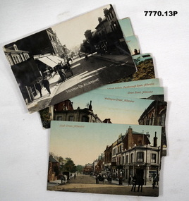 Bendigo Military Museum
Postcard - POSTCARD, ALDERSHOT, UK, Valentine's Series, c 1914 - 1918
R..H. Baron took leave from Herdcott Camp between 4.10.19918 and 8.10.1918 to visit Aldershot. See Catalogue No. 7743 for leave pass details. Relatives lived in the Aldershot area. Part of the 'Robert H. Baron', No.3596 and Cooper Collections. See Catalogue No. 19819 for details of Baron's service.1. Coloured street scene with buildings, groups of people and horse drawn transport. 2. Coloured street scene with buildings, groups of people and horse drawn transport. 3. Coloured street scene with buildings, groups of people. 4. Coloured scene features a canal with boat, tow path, bridge and house. 5. Coloured, Band marching down a street. Spectators lining the road. Church in background. 6. Coloured Group of soldiers in uniform marching along the road. Spectators, church in background. 7. Coloured statue of a man on a horse. Statue located on a hill 8. Coloured scene of gardens surrounded by buildings and a church. Groups of women. 9. Coloured - Large building with a clock tower. 10. Coloured column of uniformed soldiers on horseback. Buildings lining road. Horse drawn transport sharing road. 11. Coloured street scene with red brick building and pedestrians. 12. Coloured Monument with inscription. Buildings in background. 13. Black and wgite street scene. Street lined with buildings. Horse drawn transport. Pedestrians.1. High Street, Aldershot. 2. Wellington Street, Aldershot. 3. Union Street, Aldershot. Handwritten in black ink on back: (Notice how narrow the streets are). 4. Wharf Bridge, Farnborough Road, Aldershot. Handwritten in black ink on back: "I was all over these places with Uncle. I had a good time in Aldershot, Bob. 5. Wellington Avenue (Church Parade), Aldershot. Handwritten in black ink: 'One of the Aldershot bands', R.H. Baron.' 6. Queens Avenue and St. George's Church, Aldershot. Handwritten in black ink on back: 'Soldiers going to church". 7. Wellington Monumental, Aldershot. Handwritten on back in black ink: 'I was right up around this place!' 8. Municipal Gardens, Aldershot. Handwritten on back in black ink: 'This place is very pretty, Bob'. 9. Cambridge Hospital, Aldershot. Handwritten on back in black ink "This is a fine place!". 10. Hospital Hill, Aldershot. 11. Smith Dorrien Home, Aldershot. Handwritten on back in black ink. 'I was all over Aldershot with Uncle. I have saw all these places. Bob.' 12. R.A.M.C. Memorial, Aldershot. 13. Victoria Rd, Aldershot.robert h. baron, cooper collection, aldershot uk, postcards -
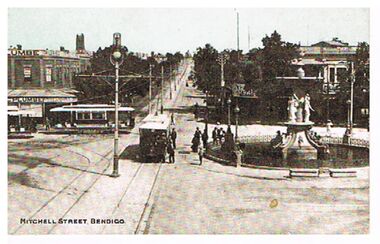 Bendigo Historical Society Inc.
Postcard - MITCHELL STREET, BENDIGO, C1907
Postcard, hand tinted. Image shows Charing Cross Bendigo, looking up Mitchell Street towards Railway line. Alexandra Fountain on RH side of image, tram heading up View Street in foreground. Two trams in Pall Mall, one a 'toast-rack' tram. Men standing near fountain and tram, woman in long dress in background behind fountain. Man on horseback coming down Mitchell Street. On north corner of Pall Mall and Mitchell ' C. Plumbe, Tailor' on top and verandah of brick building. On south side of road, on front of building ' City Club' On bottom of card: Mitchell Street, Bendigo. On rear of postcard ' Cole's Sunny Australian Series, 102 View. E.W. Cole, Book Arcade, Melbourne, Sydney, Adelaide. Wriitten on card in pen and addressed to ' Mrs. Russell, Post Office, Patho.' Message reads: A very happy Xmas to all at Patho P.O., arrived home safely, did not miss the train. Leaving on Sat. for Queenscliff. Kindest regards to all. A. Morcom.'bendigo, streetscape, mitchell street, charing cross, mitchell street, bendigo, trams, alexandra fountain -
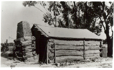 Bendigo Historical Society Inc.
Photograph - BURNT GULLY PHOTOS, 1924
Burnt Gully - possibly near Woodvale. a. Black and white photo: men standing behind, alongside bagged grain. Steam farm engine on RH side. Written on rear of photo: threshing team at lunch engine Ruston Procter steam. 8 horse power, single cylinder, working pressure 75 lbs per square inch. 80 revs per minte. Fly wheel 6 feet in diameter. b. Pilcher's thresher on Robert Riley's farm, Burnt Gully. Bullock drivers Bill Pilcher, Paddy Mulcair. Bullock drawn threshing machine, large group of men standing alongside and to rear of machine. Two men standing on top of thresher. Steam traction engine on far left of photo. c. Pioneer log cabin Burnt Gully, the home of the Grafton family, demolished about 1930. Hut of slab construction, with corruated iron roof over timber slats. Chimney of logs and slabs topped with bricks on LH side of house. Steam farm machine in background on LH side.unknownagriculture, farm, grafton familyh, robert riley, bill pilcher, paddy mulcair, burnt gully. -
 Bendigo Historical Society Inc.
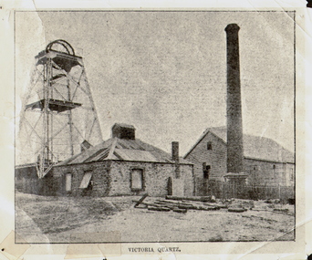
Photograph - VICTORIA QUARTZ - NEW CHUM LINE OF REEF, c.1890
Black and white photograph. Poppet head on LH side, stone building, centre, tall brick chimney, RH side in front of timber building. Inscriptions: on front - 'Victoria Quartz'. On back - typewritten description as follows: 'Situated on the rich Victoria Hill, Ironbark. Steel girders? rams type poppet legs - 60ft high. Vertical winding engines; pair of 24' dia. Winding drums. Made and erected by Roberts & Sons, Bendigo, in 1897. Then one of the best in the state. In 1910 it was the deepest gold mine in the world, having reached a depth of 4,613 ft in the winze. The shaft was then sunk to a depth of 4,588 ft. in an endeavour to reach a depth of 4,870 ft. to effectively work the deepest gold bearing reef in the world. On the night of June 14th, 1910, the mine was flooded out by the rising waters from the deep New Chum mines to the south, all of which had either ceased operations or had returned back to shallow workings. For details of the mine's record, see 'The Historical Guide to Bendigo'. Mine details completed by A Richardson, 29 Harrison Street, Bendigo.place, mining site, victoria quartz -
 Bendigo Historical Society Inc.
Book - BOOK - MAY 1937. VICTORIA TELEPHONE DIRECTORY
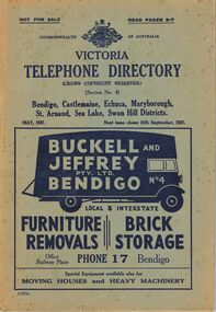
A copy of the Victoria Telephone Directory which is dated in May 1937. It features the telephone numbers for Bendigo, Castlemaine, Echuca, St. Arnaud, Sea Lakes, Swan hill Districts. The front cover also features an ad for the Bendigo moving Business Buckell and Jeffry which has a picture of a black truck with its back open and has the text "Buckell and Jeffry PTY. LTD BENDIGO Local & Interstate FURNITURE, BRICK REMOVALS, STORAGE, Office Railway Place PHONE 17 Bendigo, Special Equipment available also for MOVING HOUSES and HEAVY MACHINERY" The back cover also features two ads, one for the Hotel Ritz which details "Country Visitors to Melbourne will find the HOTEL RITZ, FITZROY STREET ST. KILDA, Conveniently situated to Beaches (3 minutes) and City (10 minutes). Electric Trams pass the door. equipped with Central heating. Hot and Cold water and House Phone in every Bedroom. Luxuriously Furnished. Execellent Cuisine. The Ritz offers the Finest in Hotel Accommodation." and the other ad for the Colonial Scale Repair Co. in Melbournebook, rural -
 Kew Historical Society Inc
Plan, Melbourne & Metropolitan Board of Works : Borough of Kew : Detail Plan No.1565, 1905
The Melbourne and Metropolitan Board of Works (MMBW) plans were produced from the 1890s to the 1950s. They were crucial to the design and development of Melbourne's sewerage and drainage system. The plans, at a scale of 40 feet to 1 inch (1:480), provide a detailed historical record of Melbourne streetscapes and environmental features. Each plan covers one or two street blocks (roughly six streets), showing details of buildings, including garden layouts and ownership boundaries, and features such as laneways, drains, bridges, parks, municipal boundaries and other prominent landmarks as they existed at the time each plan was produced. (Source: State Library of Victoria). This plan forms part of a large group of MMBW plans and maps that was donated to the Society by the Mr Poulter, City Engineer of the City of Kew in 1989. Within this collection, thirty-five hand-coloured plans, backed with linen, are of statewide significance as they include annotations that provide details of construction materials used in buildings in the first decade of the 20th century as well as additional information about land ownership and usage. The copies in the Public Record Office Victoria and the State Library of Victoria are monochrome versions which do not denote building materials so that the maps in this collection are invaluable and unique tools for researchers and heritage consultants. A number of the plans are not held in the collection of the State Library of Victoria so they have the additional attribute of rarity.Original survey plan, issued by the MMBW to a contractor with responsibility for constructing sewers in the area identified on the plan within the Borough of Kew. The plan was at some stage hand-coloured, possibly by the contractor, but more likely by officers working in the Engineering Department of the Borough and later Town, then City of Kew. The hand-coloured sections of buildings on the plan were used to denote masonry or brick constructions (pink), weatherboard constructions (yellow), and public buildings (grey). MMBW Plan No.1565 is an example of a plan where a number of streets have been created since the area was surveyed, or in other cases renamed. The plan shows those streets that were bordered by Ross Street, Mount Street, Sackville Street and Burke Road. Since 1905, Mawson Street has been created and Mont Albert Road renamed as Dean Street. Named houses on the plan include ‘Tyrol’, ‘Glengorse’, ‘Theodore Villa’, ‘Arncliffe’, ‘Ballynira’ and ‘Hazeldene’. The plan also shows a Wesleyan Church in Sackville Street. In 1883, the Church’s Sunday School celebrated its silver anniversary.melbourne and metropolitan board of works, detail plans, mmbw 1565, cartography -
 Royal District Nursing Service (now known as Bolton Clarke)
Photograph - Photograph, black and white, Barry Sutton, 1974
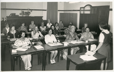
Sr. Pat (Paddy) Rowley is the Principal Nurse Educator at RDNS and is giving a lecture to RDNS Sisters in the Education Department at 452 St. Kilda Rd, Melbourne. She is wearing the RDNS summer uniform of a white short sleeve blouse under a royal blue V neck tunic style frock with the RDNS insignia on the upper left.Education was an integral part of Melbourne District Nursing Society (MDNS), from its inception in 1885, later, in 1966, called Royal District Nursing Service, (RDNS). From 1885, only Trained Nurses (Nurses), through the Hospital training system, were employed by the Society, and on visits to patients they taught the necessity of hygiene and cleanliness, as well as the need for a good diet, to bring about good health. Doctor’s lectures were later given at the MDNS home to instruct patients and their families on prevention of disease. Education to patients continued throughout the years regarding health care and the use of equipment in the home. In 1961, Education programs commenced at MDNS with Trained nurses (Sisters) receiving In-service education. Sr. Pat (Paddy) Rowley was a leader in In-service Education and established the RDNS Department of Community Nursing Education in 1962. Staff could also apply for scholarships to further their education outside of RDNS. Many of their senior Sisters received Postgraduate diplomas from the College of Nursing in Community Health Nursing, Education, and Administration, and several travelled overseas visiting nursing organizations viewing their public health and District nursing systems. At RDNS many programs were run, including: a Post Basic Course, Cardiac Rehabilitation Nursing, Haematology/Oncology Nursing, Palliative Care program, Diabetic Stabilization Program, Leg Ulcer Management Program, Wound Care Specialist Program, HIV/AIDS Nursing Care, Cystic Fibrosis Home Support, Veterans Home Care Program, Breast Cancer Support Program, Continence Management Program, Stomal Therapy Program, In-Home Lactation Support Program and the Homeless Persons Program. RDNS Sisters attended several hospitals to observe and learn special care needed to some patients, e.g. to the Austin Hospital to learn the care required for paraplegic and quadriplegic patients at home, and to Mount Royal Hospital to observe the care of patients in the Rehabilitation ward. A Community Nursing Education Program was extended to student nurses from hospitals and to other nursing organizations. These Education programs kept the RDNS Sisters abreast of new techniques, such as changes in technology for e.g. new testing methods in detecting glucose levels in Diabetic patients. Sr. Nan Deakin obtained a Post Basic Certificate in Psychiatric Nursing and included this area in her Education lectures. Sr. Daphne Geldard specialized in the area of Alzheimer’s disease and Dementia. These Sisters visited patients in District areas with the regular RDNS Sister when required. Every member of staff, both professional and non professional staff, received regular education in the Education Department. In 1980, a Home Health Aide pilot study, funded by the Federal Government, the Brotherhood of St. Laurence and RDNS, with the program written and taught by Sr. Rowley, was evaluated as successful, and Home Health Aides were employed and worked in RDNS Centres under the supervision of the RDNS Sisters. This black and white photograph shows Royal District Nursing Service (RDNS) Sister Pat (Paddy) Rowley and seventeen (some partly hidden), Royal District Nursing Service (RDNS) Sisters. The bulk of the photograph shows the front view of three rows of RDNS Sisters sitting at tables which have books and sheets of paper on them. The Sisters are wearing a variety of day clothes. In the right foreground of the Photograph is a table containing papers, and standing to its right, facing the group, is the back view of Sr. Rowley, who has short dark hair and glasses. She has her left hand on a sheet of paper on the table. She is wearing her RDNS uniform of a white short sleeve blouse under a dark tunic style frock. In the rear of the photograph a brick fireplace can be seen with some books and a vase of flowers on the mantelpiece. On the right is a long curtain, some lockers and an open wooden door with glass panel. Some of the Sisters named are:- Ann Greenwood, Judy Peter, Ethel Fullarton, Barbara Lovell, Shirley Lewis, Jane Ball..Barry Sutton Stamp. Quote LY 68royal district nursing service (1966-2017), rdns, rdns education, sister ethel fullerton, sister barbara lovell, sister shirley lewis, sister jane ball, sister pat (paddy) rowley, sister ann greenwood, sister judy peter -
 Royal District Nursing Service (now known as Bolton Clarke)
Photograph - Photograph, colour, c.1990
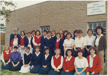
The Royal District Nursing Service (RDNS) Altona Centre was situated at Blackshaws Road, Altona. This photograph is a pictorial record of the staff at Altona Centre in the 1990s.Gradually over the years, Melbourne District Nursing Service (MDNS), later known as Royal District Nursing Service (RDNS) from 1966 when they received Royal patronage, opened Centres throughout the Melbourne Metropolitan area and outer suburbs with Heidelberg Centre opening in 1971. Their Trained nurses (Sisters) left from these Centres each morning to carry out their nursing visits in a specific area (district), taking any sterilized equipment needed with them. They returned at the end of the day to write up their patients nursing histories, clean and reset any equipment used ready for sterilization, and contact other medical and community personal as necessary. The Trained nurses (Nurses) of the Melbourne District Nursing Society (MDNS), later known as Royal District Nursing Service (RDNS), visited patients in their home and gave best practice care in many fields of nursing, and to people of many cultures, throughout its 130 years of expansion. Initial visits not only assessed the specific nursing situation but the situation as a whole. Their patients ranged in age from babes, children, adults to the elderly and referrals were taken from Hospitals, General Practitioners and allied Health facilities. Some of the care their Trained nurses (Sisters) provided is as follows: – Post-Natal care given to mother and babe, Wound Care following various types of surgery, accidents, burns, cancer, leg ulcers etc. Supervising and teaching Diabetic Care, including teaching and supervising people with Diabetes to administer their own Insulin, and administering Insulin to those unable to give their own injections. Administering other injections and setting up weekly medication boxes. The Sisters performed Catheterizations on adults suffering from conditions such as Quadriplegia, Paraplegia, Multiple Sclerosis (MS), Motor Neurone Disease (MND) and Guillan-Barre Syndrome, and when required at school on children for e.g. those with Spina Bifida. The Sisters visited those requiring Cystic Fibrosis support and care; those requiring Haemo-Oncology care, including visiting children at school; those requiring Home Enteral Feeding care, and those requiring IV therapy at home and home Dialysis. Palliative Care was given including pain relief with the use of syringe drivers, personal care as needed, and advice and support to both patient and family. The Sisters provided Stoma management to those needing Urostomy, Ileostomy and Colostomy care and those requiring Continence care. HIV/AIDS nursing care was provided; visits to Homeless Persons were made. Personal care was given to patients ranging in age and with varying mobility problems, such as those with MS, MND, Guillan-Barre Syndrome, Poliomyelitis, Quadriplegia, Paraplegia, Acquired Brain Injury, to those following a Cerebrovascular Accident (Stroke), those with severe Arthritis and those with a form of Dementia. When necessary the elderly were assisted with personal care and advice given on safety factors with the use of hand rails, bath or shower seats, and hand showers. Rehabilitation with an aim towards independence remained at the forefront of the Sister’s minds and when possible using aids and instruction on safe techniques enabled the person to become fully independent. All care included giving advice and support to the patient and their Carers. The Sisters liaised with the persons Doctor, Hospital and allied Health personal when necessary.The coloured photograph shows 29 female staff of the Royal District Nursing Service (RDNS), Altona Centre. The rear and centre rows of staff are standing and the front row of staff are kneeling. They are outside a grey brick building with a flat roof. A white sign is on the right hand upper corner of the building and has the words, written in blue capital letters, "Royal District Nursing Service Altona Centre". Part of a window can be seen beneath this. Part of two other windows can be seen in the centre and to the left of the building. Most Sisters are wearing RDNS uniforms, some with a short sleeve white with a blue pattern dress and a red belt. Others with a white with pattern blouse and dark blue skirt, and some have a red sleeveless jumper over their uniform, and some are wearing a dark blue cardigan or long sleeve dark blue jumper. Three staff are wearing day wear, one with a purple blouse and black skirt, another with a white blouse and pale blue skirt and the third wearing a white blouse, brown cardigan and bone slacks.. royal district nursing service, rdns, rdns centre, rdns uniform -
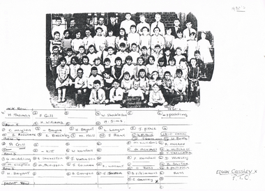 Bendigo Historical Society Inc.
Photograph - LONG GULLY HISTORY GROUP COLLECTION: LONG GULLY SCHOOL PHOTO 1920'S
Copy of a black and white Long Gully School 2120 Photo Grades III - V from the 1920's. Children are sitting or standing outside a brick building. Two children in the front row are holding up a blackboard with the name of the school and grades written on it. The known names are written under the photo. They are: H Thomas, F Gill, H Williams, W Sheckleton, H Sims, Spedding, C Mylon, E Rosewarne, Bryar, E Brockley, H Bryant, M Hall, L Lanyon, J Rowe, J Pithie, H Pithie, J Grossman, O Ermal, U? Betts, A Gill, Kitt, W Kendall, M Williams, G? Marshal, R Michell, W Mitchell, T Trewarta, A Middling, M Clapton, E Shekelton, M Phillipson, J Waterson, J Conner, Z Wallent, P Kendall, O Ross, D Harvey, B Salter, B Phillipson, H Bryant, B Grenfell, J Salter, B Fitzsimmons, E Crossley and Ross. The year and the name Edwin Crossley is written on the paper.bendigo, history, long gully history group, the long gully history group - long gully school photo 1920's, h thomas, f gill, h williams, w sheckleton, h sims, spedding, c mylon, e rosewarne, bryar, e brockley, h bryant, m hall, l lanyon, j rowe, j pithie, h pithie, j grossman, o ermal, u? betts, a gill, kitt, w kendall, m williams, g? marshal, r michell, w mitchell, t trewarta, a middling, m clapton, e shekelton, m phillipson, j waterson, j conner, z wallent, p kendall, o ross, d harvey, b salter, b phillipson, h bryant, b grenfell, j salter, b fitzsimmons, e crossley, ross. -
 Kiewa Valley Historical Society
Photographs - Demolition of the old Tawonga District General Hospital. Set of 8 colour photographs
In the early stages of the Kiewa Hydro-Electric Scheme the State Electricity Commission took over the financial and construction responsibility of the Tawonga District General Hospital building at a cost of 27,000 pounds. This included the removal and re-erection of the ex-military Bonegilla ward from Wodonga while in addition they carried out all the necessary building works that allowed the hospital to operate as a functional unit. The work was completed and handed over to the Hospital Committee of Management on September 1, 1949. Local residents raised 3,400 pounds through fund raising. The balance was met by the SEC and the Hospital and Charities Commission. The initial project was to provide for a basic temporary hospital which was later to include an Operating Theatre, Offices, Store, Mortuary and a Nurse’s Home, until the establishment of a permanent medical premises. Following the opening, 455 patients were admitted to the Tawonga District General Hospital and 254 operations were performed in the first year. The hospital relocated to Mount Beauty in the former SEC administration offices located in the town centre. Official opening of the 18 bed Tawonga District General Hospital on April 29 in 1961. The old weatherboard building was demolished around the late 1900’s to early 2000’s and replaced with a new modern brick building. Alpine Health CEO Mr Lyndon Seys oversaw the opening of the new Mount Beauty Hospital in November 2001 alongside Board of Management President Mr Andrew Randell, other board members and politicians. The Kiewa Hydro-Electric Scheme the State Electricity Commission played a pivotal part in the planning and initial funding of the Tawonga District General Hospital, with a view to providing medical support for its many workers on the Hydro scheme. Later, spouse and family members of workers were also able to access medical assistance The hospital was originally located in Tawonga away from the majority of the patients as the Hospital and Charities Board was not prepared to have it within the SEC controlled area and it was not until the gate at Tawonga South was taken down that the hospital was moved to the main centre of population at Mount Beauty.8 Colour photographs of the demolition of the original Tawonga and District Hospital situated in Mt Beauty circa 20001. No inscriptions 2. Side view of Tawonga District General Hospital, 1990’s 3. Demolition of the weatherboard hospital: Nurses station, ward and corridor 4. Demolition of the weatherboard hospital: kitchen & utility rooms 5. Demolition of the weatherboard hospital” front entrance & gardens 7. Demolition of the weatherboard hospital: Matrons House 8. No inscriptions tawonga & district general hospital; kiewa hydro electric scheme; mt beauty; -
 Kiewa Valley Historical Society
Photographs – Old Tawonga District General Hospital Mt Beauty. Set of 19 colour photographs
In the early stages of the Kiewa Hydro-Electric Scheme the State Electricity Commission took over the financial and construction responsibility of the Tawonga District General Hospital building at a cost of 27,000 pounds. This included the removal and re-erection of the ex-military Bonegilla ward from Wodonga while in addition they carried out all the necessary building works that allowed the hospital to operate as a functional unit. The work was completed and handed over to the Hospital Committee of Management on September 1, 1949. Local residents raised 3,400 pounds through fund raising. The balance was met by the SEC and the Hospital and Charities Commission. The initial project was to provide for a basic temporary hospital which was later to include an Operating Theatre, Offices, Store, Mortuary and a Nurse’s Home, until the establishment of a permanent medical premises. Following the opening, 455 patients were admitted to the Tawonga District General Hospital and 254 operations were performed in the first year. The hospital relocated to Mount Beauty in the former SEC administration offices located in the town centre. Official opening of the 18 bed Tawonga District General Hospital was on April 29 in 1961. The old weatherboard building was demolished around the late 1900’s to early 2000’s and replaced with a new modern brick building. Alpine Health CEO Mr Lyndon Seys oversaw the opening of the new Mount Beauty Hospital in November 2001 alongside Board of Management President Mr Andrew Randell, other board members and politicians. The Kiewa Hydro-Electric Scheme the State Electricity Commission played a pivotal part in the planning and initial funding of the Tawonga District General Hospital, with a view to providing medical support for its many workers on the Hydro scheme. Later, spouse and family members of workers were also able to access medical assistance The hospital was originally located in Tawonga away from the majority of the patients as the Hospital and Charities. Many SEC workers and their families have received medical care at Tawonga District General Hospital and Alpine Health over the years. A number of family members of SECV workers as well as other dedicated staff have provided high quality medical attention and support in all the facilities as nursing staff, support staff and volunteers. Many past staff members and their families still remain living in the Kiewa Valley area 19 Colour photographs of the Tawonga and District Hospital situated in Mt Beauty circa 2000. Including photographs of interior and of some staff members1. No markings 2. G Ryder at front entrance 3. Sister G Ryder in the Resuscitation Room 4. Nurse D Hateley in the Kitchen 5. Nurse D Hateley in the Casualty Room 6. Sister W McClelland in new nurse’s station 7. R Forrest, G Ryder, ?, M Ranton 8. Nurse D Hateley in the Pan Room 9. Tawonga District General Hospital: Resuscitation Room 10. Hospital Hallway 11. Empty Nurses Station 12. Tawonga District General Hospital: Nursery 13. Patient Tea Room 14, 15, 16, 17, & 18. No marking mt beauty district hospital, tawonga district hospital, bonegilla ward, ryder family -
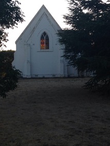
 Eltham District Historical Society Inc
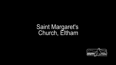
Film - Video (Digital), Geoff Paine, St Margaret's Church, Eltham: Stories of the Nillumbik Shire with Geoff Paine, June 2020
One of a series of videos "Stories from the Nillumbik Shire with Geoff Paine" Geoff Sandy, Parish Historian and Archivist gives a history of the church which was opened 12 December 1861. It is constructed of polychrome bricks (lots of different colours). References a long relationship of over 159 years between the church committee and the Eltham Hotel across the road for refeshments for church events. The land was donated by Henry Dendy, the founder of Brighton where he lived for five years before going bankrupt and moving to Eltham where he bought a steam powered flour mill on the banks of the Diamond Creek at the end of Pitt Street. The church is heritage protected as well as the 1870 parsonage, Dendy House. It was always meant to be a much bigger church and extended along the north wall. This was finally achieved in 2014. Shows views inside of the original section and the extension. Also discusses the original tall windows on the south with gold trimming and other windows with gold trimming. Some original windows have been replaced by stained glass. Discussion about the Patron Saint of the Church, Margaret of Scotland. The original window made for £1 by Yuri and Fergusson in Melbourne and possibly one of the first made in the Colony of Victoria was relocated to the north wall during the 2014 extension. The crucifix was made by Matcham Skipper. Also features the Honour Roll. The walls of the extension are mudbrick, timber from a variety of sources and very much in keeping of the character of Eltham. The bell and bell tower are original. At the end of the First World War the bell was rung so vigorously that the bell broke.MP4 Digital file 00:05:48; 672MBvideo recording, church bell, dendy house, eltham, eltham hotel, flour mill, geoff sandy, henry dendy, honour roll, matcham skipper, mudbrick construction, pitt street, st margaret's anglican church, stained glass -
 Eltham District Historical Society Inc
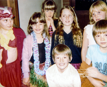
Photograph, Sir Oliver's Song, Eltham Christian School, 18 August 1983, 1983
Sir Oliver's Song, Eltham Christian School, 18 August 1983. Children performed songs from "Sir Oliver's Song" - a Christian children's album by the Dove Award winning and Grammy Award nominated group Candle, rleased in 1979. It teaches the 10 Commandments through songs that are based on musical styles from around the world. (Source: Wikipedia) The Stokes family settled in this area of Eltham in the 1940s and were associated with the Eltham Christian Church. In the 1970s this church had met in temporary premises in Eltham. Lots of the original 1920s subdivision remained south of Nyora Road and a number of these lots were utilized for the Eltham Christian School, which was established by the Eltham Christian Church in 1981. The school operated on this site until 2000. The premises were owned by the Nillumbik Community Church who were in operation till November 2010 when the Eltham Baptist Church commenced a lease arrangement until the site was purchased by them in April 2012. The building is constructed of brick and timber with a balcony on two sides that looks over an expanse of grass. Sources: STOKES ORCHARD – AN INCOMPLETE HISTORY February 28, 2015 http://www.elthamhistory.org.au/ Australian Christian Church Histories - Eltham Baptist Church http://www.churchhistories.net.au/church-catalog/eltham-vic-baptist/ From a magnetic spiral bound photo album featuring a series of photographs (some cropped) with captions relating to the staff, students and activities of the Eltham Christian School which operated as part of the Eltham Christian Church at Nyora Road, Eltham. See also entries for each photograph.Colour photographeltham christian school, nyora road, concert -
 Eltham District Historical Society Inc
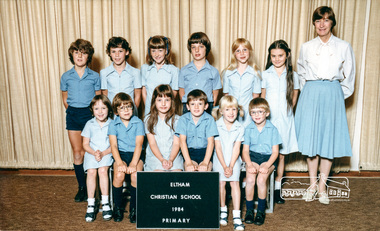
Photograph, Primary, Eltham Christian School, 1984, 1984
ROW 2 L -R: David Prentice, Jessica Doedens, Jackie Levering, Darren Watts, Fiona Berry, Karen Whalley, ROW 1 L - R: Rachel Berry, Andrew Mitton, Natasha Watts, Peter Whalley, Marissa Vail, Aaron Mitchell, Teacher: Mrs. Humphreys Class: PRIMARY The Stokes family settled in this area of Eltham in the 1940s and were associated with the Eltham Christian Church. In the 1970s this church had met in temporary premises in Eltham. Lots of the original 1920s subdivision remained south of Nyora Road and a number of these lots were utilized for the Eltham Christian School, which was established by the Eltham Christian Church in 1981. The school operated on this site until 2000. The premises were owned by the Nillumbik Community Church who were in operation till November 2010 when the Eltham Baptist Church commenced a lease arrangement until the site was purchased by them in April 2012. The building is constructed of brick and timber with a balcony on two sides that looks over an expanse of grass. Sources: STOKES ORCHARD – AN INCOMPLETE HISTORY February 28, 2015 http://www.elthamhistory.org.au/ Australian Christian Church Histories - Eltham Baptist Church http://www.churchhistories.net.au/church-catalog/eltham-vic-baptist/ From a magnetic spiral bound photo album featuring a series of photographs (some cropped) with captions relating to the staff, students and activities of the Eltham Christian School which operated as part of the Eltham Christian Church at Nyora Road, Eltham. See also entries for each photograph.Colour Photographeltham christian school, nyora road, david prentice, jessica doedens, jackie levering, darren watts, fiona berry, karen whalley, rachel berry, andrew mitton, natasha watts, peter whalley, marissa vail, aaron mitchell, mrs humphreys -
 Eltham District Historical Society Inc
Negative - Photograph, George W. Bell, Excavation of site for new Eltham Shire Office building, 895 Main Road, Eltham, 1964
Black and white photograph of bulldozer excavating the former Shillinglaw Cottage site for new Shire Offices. 'Shillinglaw Trees' in background. The cottage and land were purchased by the Shire of Eltham as the site for a new shire office building. The cottage was destined for demolition but members of the community concerned at losing one of the areas earliest buildings (built c.1859) initiated a fund-raising campaign to save the cottage. In 1964 the cottage was dis-assembled, all the bricks numbered and reassembled several hundred meters to the south on a site between the Gahan house and the Eltham Railway Trestle Bridge (present-day Panther Place), which became known as the Eltham Common. The new shire offices at 895 Main Road were opened in 1965. Following the Kennett Government amalgamation of local government areas in 1994, the Shire of Eltham ceased to exist, and a new Shire of Nillumbik was created 15 December 1994 from the former Eltham shire and parts of the Diamond Valley shire. The former West Riding which included parts of Montmorency, Lower Plenty and Briar Hill were ceded to the new City of Banyule. Commissioners were appointed for several years and the new Council occupied the former offices of the Shire of Diamond Valley in Greensborough. The former Eltham Shire offices remained vacant until August 1996 the Commissioners suddenly elected to have the former Shire offices demolished immediately and the site has remained vacant ever since. It was not until 1997 before the community was allowed to democratically elect new Councillors to represent them. This photo forms part of a collection of photographs gathered by the Shire of Eltham for their centenary project book,"Pioneers and Painters: 100 years of the Shire of Eltham" by Alan Marshall (1971). The collection of over 500 images is held in partnership between Eltham District Historical Society and Yarra Plenty Regional Library (Eltham Library) and is now formally known as the 'The Shire of Eltham Pioneers Photograph Collection.' It is significant in being the first community sourced collection representing the places and people of the Shire's first one hundred years.Digital image 4 x 5 inch B&W Negeltham, eltham shire office, excavation, george w. bell collection, main road, municipal offices, shillinglaw cottage, shillinglaw trees, shire of eltham pioneers photograph collection, shire offices, significant tree -
 Eltham District Historical Society Inc
Photograph, Liz Pidgeon, Heritage Excursion; Maroondah Aqueduct, 3 September 2016, 3 September 2016
Heritage Excursion - Maroondah Aqueduct Walk - Saturday 3rd September The Maroondah Aqueduct was once a major link in Melbourne’s water supply system. It was built between 1886 and 1891 to transfer water from the Watts River near Healesville to the Preston Reservoir. It was 66 km in length, made up of 41 km of open channel, 10 km of tunnel through hills and 15 km of pipeline across stream valleys known as inverted siphons. The section of the aqueduct through the Eltham area has been abandoned since the 1980s but the open channel has largely been retained. A recreational path follows the aqueduct reserve. For our excursion on 3rd September we intend to walk along the section of the aqueduct adjacent to Allendale Road. This is a section not visited on previous excursions and includes the transition from open channel to the inverted siphon across the Diamond Creek valley. Apart from the aqueduct itself the main feature of the walk is the extensive views across Eltham North and Diamond Creek. Along the way we will talk about the history of the aqueduct and the area. This easy walk is about 3 km return and will take 2 to 2.5 hours. It will start at 2pm at the junction of Allendale Road with Godber Road and Zig Zag Road North, officially Diamond Creek, but on the northern boundary of Eltham. (Melway ref.12 B10). Newsletter No., 229, August 2016 Brick bridge on Parsons road, Eltham North over the aqueduct on the aqueduct trail. Born Digitalmaroondah aqueduct, eltham north, activities, eltham district historical society, heritage excursion, parsons road, bridges, aqueduct trail -
 Victoria Police Museum
Police Stations (Apollo Bay)
Apollo Bay is a coastal town in southwestern Victoria. It is situated on the eastern side of Cape Otway, along the edge of the Barham River and on the Great Ocean Road, in the Colac Otway Shire. The original township was surveyed in 1853 and named Middleton. In 1881 the town was renamed Krambruk which was changed to Apollo Bay in 1898. The Krambruk Police Station was opened on 7 March 1888 in the Southern District on land opposite the site of the current Mechanics' Institute and changed its name to the Apollo Bay Police Station on 1 September 1990. It came under the Barwon District in 1948 and "Lima" Western District from 4 March 1990. In 1930 the police station was located to 29 Nelson Street. It was a seven-roomed weather-board dwelling on three-quarters of an acre of land. It consisted of six rooms of pine, lined and painted; one pantry; one bathroom and wash-house; one hall; one office and one W.C.. There was stabling for one horse and one cell for prisoners. It was staffed by one Mounted Constable. In the early 1970s land was acquired at 31 Nelson Street and a new police station was constructed. This was a three-roomed brick building with a cell block at the rear. By the time it closed in 2005 it had been extended twice. On 17 November 2006 the current Apollo Bay Police Station opened in its current location at 35a Nelson Street, on the corner of Cartwight Street). Outside the peak summer season, the station is open 16 hours per day and staffed by one sergeant and five other members. 3 black & white photos and 2 coloured photospolice stations; apollo bay police station -
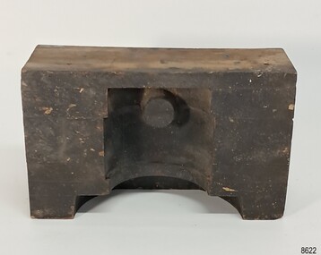
 City of Moorabbin Historical Society (Operating the Box Cottage Museum)
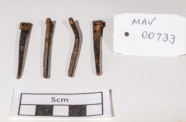
Building Equipment, original hand made nails Box Cottage c 1850, c1850
The original small, pioneer cottage was built in the late 1840s to early1850s, by an unknown pioneer. It was located on part of a 30 Acre allotment that was originally part of Henry Dendy’s Special Survey granted in 1841. The doors and window sashes, (made of red deal joinery timber), as well as the brass locks and fittings, are from the original cottage, and were imported from England.The fire-place bricks are from the original cottage, and are sun-dried, (not kiln fired), and are hand-made. Convict marks can be seen on two bricks.There is a small display of external cladding shingles from the original pioneer cottage. These shingles were hand-split, and most likely made from locally collected timber The nails included in this display were used to fasten the shingles on the original cottage, and are also hand-made. The enamel nameplate, “Colonial”, on the wall of the cottage, was the name chosen for the original pioneer cottage when a later owner, Mr August Rietman and wife Frieda leased the property in around 1917. August purchased the property 1935 for 1200 Pounds approximately and resided there until 1953. In 1974 Mr Lewis, a timber specialist, found the dilapidated building on property he had recently purchased in Jasper Rd and suggested it be reconstructed and relocated. Moorabbin Council agreed and the Cottage was rebuilt just about 250 metres from its original site. The cost of the rebuild was met by 'Victoria's 150th Committee', plus a small grant from the City of Moorabbin, and Mr Laurie Lewis donated much of the timber for the reconstruction. Theses 4 iron nails were hand made by an early settler c1850, using iron, forge and anvil, for the construction of the original Box Cottage 4 hand made iron nails c1850 used in building the original pioneer cottage now known as Box Cottage Museumbox william, box elizabeth, brighton, henry dendy special survey 1841, early settlers, pioneers, moorabbin, box cottage museum, nails, building equuipment, forges, anvils, blacksmiths -
 Ballarat and District Irish Association
Photograph - digital, Shane Dunne, St Mary's Catholic Church Clarendon, 2014, 2014
St Mary's Clarendon was dedicated on 09 November 1871. In 2014 it is part of St Alipius Parish, Ballarat East. "OPENING OF THE NEW CHURCH AT CLARENDON. On Thursday, November 9th, his Lordship the Bishop, accompanied by the various clergymen who assisted at the Mission, left Ballarat early in the morning, and proceeded through Buninyong to open the new church recently erected by the untiring exertions and liberality of the Catholics of Clarendon, and dedicated to the Blessed Virgin under the title of 'Auxilium Christianorum.' The church, which is composed of stone, with Lal Lal white brick facings, is 43 feet long by 20 feet wide, including a nice chancel, and has cost up to the present about £500. As the Bishop was approaching the locality, a large number of horsemen met and escorted, him to the church, arriving at 11 o'clock. Here also were a large number of children, 192, prepared for Confirmation, who were similarly attired as candidates in Ballarat. A procession, headed by the cross bearer and acolytes, was formed of the children and moved round the church, followed by the clergymen and the Bishop, who sprinkled the edifice with holy water. The building having been blessed and consecrated, High Mass, coram episcopo, was celebrated by the Very Rev. Dean Moore, the Rev. T. O'Donnell acting as deacon, Rev. M. J. Shanahan, as sub-deacon, and Rev. J. D. O' Sullivan, as master of ceremonies. After the Communion the Rev. J. D. O'Sullivan preached an impressive sermon on devotion to the Blessed Virgin. The collection amounted to about £40.9." (freeman's Journal, 25 November 1871)Six colour photographs of exterior and interior views of St Mary's Clarendon. st mary's clarendon, clarendon, st mary's, catholic -
 Surrey Hills Historical Society Collection
Document - Contract of sale, Contract of sale for 33 Kingston Road, Surrey Hills
No 33 Kingston Road is a red brick attic-style house which was built c1920. Edward Edwards (1880-1963) was a blacksmith and the first owner. The house was named 'Berwyn' (Ref: 1931 electoral roll). Edward's wife was Mary Kennedy Stewart (1873-1931). They had 7 children, all born before the family came to Surrey Hills: 1. Hazel Margaret Kennedy Edwards (1896-1966) - dressmaker in 1931 electoral roll 2. Edward Alexander Edwards (1898-1988) 3. Mary Gwendolyn Edwards(1899-1942) 4. Gladys Annie Edwards (1902-1988) - hairdresser in 1931 electoral roll 5. Clarence Edwards (1906-1988) - plumber in 1931 electoral roll 6. Alan Stewart Edwards (1909 - 1996) 7. Geoffrey Ellis Edwards (1910-1985). The property passed to Edward Henderson Redpath after Edward Edward's death. He was a mechanic. (Ref: 1963 electoral roll). He was born in Shilbottle England on 3 December 1904 and married Gladys Annie Edwards in 1932 (#8417). He served in the Australian Airforce during WW2. Thus, the property was owned by the same family for over 40 years. Edward Henderson Redpath sold the property to David Murray Flynn and Heather Rosemary Flynn of 18 Kingston Road, Surrey Hills in 1965. Associated records: 1. Letter from George Henderson P/L to T Redpath, 1965 2. Letter re estate of E H Redpath, 1969. A standard folded real estate contract of sale for 33 Kingston Road, Surrey Hills, dated 14 August 1965edward edwards, berwyn, 33 kingston road, mary stewart kennedy, mary stewart edwards, houses, real estate contracts, legal documents, hazel margaret kennedy edwards, edward alexander edwards, mary gwendolyn edwards, gladys annie edwards, clarence edwards, alan stewart edwards, geoffrey ellis edwards, edward henderson redpath, gladys annie redpath, david murray flynn, heather rosemary flynn, house names -
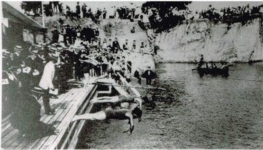 Surrey Hills Historical Society Collection
Photograph, Carnival Day at Surrey Dive, Possibly 1909
This photo records one of the swimming carnivals held at the Surrey Dive, the first of which was organised in 1907. It was at the 1907 carnival that champion swimmer Frank Beaurepaire won the one-mile championship in record time. In the era before purpose-built municipal swimming pools, Surrey Dive was a popular destination for swimming and people came to it from many Melbourne suburbs. It operated from 1905 to 1967. It was the newly formed Surrey Park Swimming Club (established in 1905) that petitioned the Box Hill Council to purchase the former quarry site associated with the Box Hill Brick Works. A ramp, bathing sheds, springboards, and eventually a 10-lane course were developed, making the Dive the first Olympic standard pool in Australia. The carnivals attracted huge crowds. The original use as a quarry explains the notorious depth of the swimming hole and the sheer, steep cliffs surrounding it. These posed obvious safety issues, as did the water quality. Ivy Lavinia Weber, who was the second woman to be elected to the Victorian parliament (the first at a general election) and renowned for her commitment to health and physical fitness, campaigned for State government assistance to build new baths. These were built adjacent to the Dive and were opened in 1939. The Dive continued as a facility used by experienced swimmers until 1967 when it closed due to the drought causing the water to dry up. Today the site has been turned into an ornamental lake. This image was used as a mural in the refurbishment of the Box Hill Aqualink. The image has strong associations with early industry (brick making), recreation and particularly the early history of the sport of swimming.Black and white photo with a white border. Scan shows image only. It shows 3 men diving from a wooden platform into an area of water beneath higher banks. There is a boat in the background, a building to the LHS of the photo and many spectators in boater hats on the platform, some in bathing suits along a ledge and many around the top of the bank. Two men in the LH foreground may be officials.Printed long the bottom edge of the frame: "An image from history - Carnival Day at the Dive. / (photo: Box Hill Council)"surrey dive, box hill brick works, swimming, surrey park swimming club, (mr) frank beaurepaire, (mrs) ivy lavinia weber, swimming carnivals -
 The Beechworth Burke Museum
Geological specimen - Olivine Crystals, Unknown
Olivine is mostly found on the Earth's surface in igneous rocks that are dark-coloured. It is common at divergent plate boundaries and at warm spots, such as volcanic areas. It crystalises and forms during the cooling of magma. Olivine is used in refractory sand, bricks, and gemstones. Olivine has been found on a number of meteorites, which might have originated from large asteroids or the mantle of a now-destroyed planet. This olivine crystal is thought to originate from Mount Noorat, with speculation that it could have originated from Mount Shadwell. Mount Noorat is a dormant volcano cone located in the Newer Volcanics Province of Victoria. Mount Noorat belongs to the Kirrae Wuurong people, who used the Mount as a place for meetings and gatherings prior to European settlement. Contact was first made between European settlers and the Indigenous people in 1841. The Mount has mostly been used for cattle and sheep grazing. Mount Shadwell is a well-known source of olivine and is the highest of a gathering of volcanic cones. The New Volcanic Province is located in South East Australia and covers 15000 square kilometres. It contains 400 explosive vents and small shield volcanoes. The last eruption is thought to have occurred 5000 years ago at Mount Gambier and Mount Schank. This olivine crystal has been identified as a volcanic bomb, which is a molten rock which was pushed out and ejected into the air when a volcano reupts. A rock needs to be larger than 65 mm in diameter to be classified as a volcanic bomb. This olivine volcanic bomb and its locality is historically and socially significant. The olivine was found in the Newer Volcanic Province, an area which contains over 400 dormant volcanoes. This olivine is one part of a volcanic bomb, which would have ejected when magma erupted out of a volcano. This specimen is part of a larger collection of geological and mineral specimens collected from around Australia (and some parts of the world) and donated to the Burke Museum between 1868-1880. A large percentage of these specimens were collected in Victoria as part of the Geological Survey of Victoria that begun in 1852 (in response to the Gold Rush) to study and map the geology of Victoria. Collecting geological specimens was an important part of mapping and understanding the scientific makeup of the earth. Many of these specimens were sent to research and collecting organisations across Australia, including the Burke Museum, to educate and encourage further study.A solid iron-magnesium silicate mineral with shades of green and brownburke museum, beechworth, geological, geological specimen, olivine, igneous rock, volcanic, gemstones, volcanic bomb, meteorites, asteroids, plantes, mount noorat, mount shadwell, indigenous, kirrae wuurong people, newer volcanics province, victoria, european settlement, eruption -
 Flagstaff Hill Maritime Museum and Village
Equipment - Pattern, Briggs Brass Foundry, Early 20th century
The wooden pattern is part of a set that are stored in a strong wooden crate. It was used at Briggs’ Brass Foundry for making sand casts. The traditional craft of sand casting is over 2000 years old. The handcrafted process produces brass and copper alloy goods that are well suited to marine use; bells, boat hooks, cowls, propellers, handles, lids, rowlocks, hooks, letters, bolts, rail holders, brackets, deck plates, flanges, rudder guides, portholes and covers. Briggs’ Bronze mixture is a copper-based alloy made from local ingots of copper, tin, zinc and lead in carefully measured quantities. The finished product is non-ferrous and can last indefinitely. The crate of patterns was donated by the Briggs family in the early years of Flagstaff Hill, along with other related items such as brassware, tools and machinery. The donated items were displayed in a simulated Brass Foundry in the Village along with other working crafts, trades and services found in a Maritime town. The items were on show from the completion of the building in 1986 until 1994 when the building was repurposed. The patterns represent the trades of foundering and metalwork, both supporting maritime industries such as shipwrights and boatbuilders. Farmers, manufacturers and other local industries also needed the castings made by foundries. The Brass Foundry included a historic Cornish chimney set up as a working model, to tell the story of smelted metal heated in furnaces then be poured into the sand moulds. This chimney was made from specially curved bricks and is now about two-thirds of its full height when originally located at the Grassmere Cheese factory. The craft of sand-casting from carved wooden patterns to create metal is an example of skills from the past that are still used today. The foundry pattern set is significant for its association with brass foundries locally and generally in coastal areas of Victoria. Marine industries such as ship and boat building rely on good quality castings for their machinery, equipment and fittings. Briggs Brass was especially formulated using non-ferrous metals to ensure their longevity. The patterns are associated with the long-running firm Briggs Brass Foundry that specialised in cast goods for the marine industry, ready to supply the needs for once-off or mass-produced items. Their products would have been fitted to sail and steam vessels along coastal Victoria including Warrnambool. Briggs Marine was also a bell-founder specialist and is also associated with the Schomberg Bell at Flagstaff Hill, having restored it to is former state as a fine example of the bell from a luxury migrant vessel from the mid-19th century. Pattern; rectangular wooden block made from laminated sections of wood painted black. A half-cylinder shape was carved into the long side, and a dowel shape was placed at the lower side. The pattern is part of a set of foundry patterns from Briggs Brass Foundry.flagstaff hill, flagstaff hill maritime museum and village, warrnambool, maritime museum, maritime village, great ocean road, shipwreck coast, briggs' bronze, traditional method, trade, sand cast, cast, brass alloy, copper alloy, pattern, mould, foundry, brass foundry, metal foundry, casting, sand mould, sand casting, marine equipment, marine tools, marine fittings, copper tin zinc lead, non-ferrous, non-corrosive, brassware, metalware, foundering, metalwork, maritime, bell founders, ship chandlers, marine products, biggs, briggs family, herbert harrison briggs, h h briggs, george edward briggs, cyril falkiner mckinnon briggs, cyril briggs, briggs & son brass foundry, h h briggs & sons foundry, briggs marine, alliance casting & engineering solutions, grassmere cheese factory, cornish chimney, curved bricks, collingwood, moorabbin, collingwood foundry, moorabbin foundry, 1912