Showing 927 items
matching write
-
 Mt Dandenong & District Historical Society Inc.
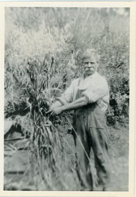
Photograph, Robert Logan
Robert Logan took up Lot 28 in the Village Settlement in 1896 and worked it until his death in 1936. His second son, Malcolm, took over the selection and continued to work it until he married and then it was subdivided. This photograph shows the oats that Robert Logan grew to feed his horse. John Lundy-Clarke grew up in the Kalorama/Mt Dandenong area and later in life (1972-74) began to write a comprehensive history of the area working from an original settlement map in an effort to cover all areas.Black and white photograph of a white haired man with a large white moustache man wearing overalls tying up a sheaf of hay. Handwritten description on reverse by John Lundy-Clarke.Robert Logan with hay grown on LOT 28 SECTION 1 of the Village Settlement. He was the original selector and his LOT was the last worked fully (by his son Malcolm) in SECTION 1. 1920. robert logan, logan, malcolm logan, kalorama, john lundy-clarke -
 Mt Dandenong & District Historical Society Inc.
Photograph
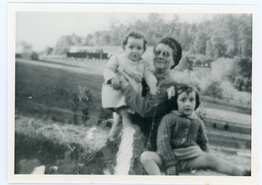
The Wenborn family acquired Ferguson's Lot 19 of the Village Settlement where the original Mount Dandenong School was opened in a shed. WH Collom owned the land after Ferguson and then it passes to the Wenborns. This photograph, taken c1942, shows Ivy Wenborn with her daughters Mary and Joan. John Lundy-Clarke grew up in the Kalorama/Mt Dandenong area and later in life (1972-74) began to write a comprehensive history of the area working from an original settlement map in an effort to cover all areas.Black and white photograph of a woman nursing a young girl Another young girl is seated at her right.Behind is a view of trees and a house. Handwritten inscription on reverse by John Lundy-ClarkeWenborn Family. Looking across what is now Kalorama Park showing Norman Jeeves' house behind the hedge to the left of the child.wenborn, ivy wenborn, mary wenborn, joan wenborn, norman jeeves, kalorama park, jeeves -
 Kew Historical Society Inc
Plan - Subdivision Plan, Riversdale Estate, 1939
The Kew Historical Society collection includes almost 100 subdivision plans pertaining to suburbs of the City of Melbourne. Most of these are of Kew, Kew East or Studley Park, although a smaller number are plans of Camberwell, Deepdene, Balwyn and Hawthorn. It is believed that the majority of the plans were gifted to the Society by persons connected with the real estate firm - J. R. Mathers and McMillan, 136 Cotham Road, Kew. The Plans in the collection are rarely in pristine form, being working plans on which the agent would write notes and record lots sold and the prices of these. The subdivision plans are historically significant examples of the growth of urban Melbourne from the beginning of the 20th Century up until the 1980s. A number of the plans are double-sided and often include a photograph on the reverse. A number of the latter are by noted photographers such as J.E. Barnes.The Riversdale Estate in Hawthorn created a subdivision of 20 allotments bordering on Riversdale Road and Riversdale Court (which was created by the subdivision). The Locality Plan at right lists the major public buildings in the area: Burnely Horticultural Gardens, Hawthorn Tram Depot and Railway Station, Scotch College and the River Yarra and The Boulevard.subdivision plans - hawthorn, riversdale estate -
 Kew Historical Society Inc
Plan - Subdivision Plan, Corsewall Estate, Hawthorn, 1938
The Kew Historical Society collection includes almost 100 subdivision plans pertaining to suburbs of the City of Melbourne. Most of these are of Kew, Kew East or Studley Park, although a smaller number are plans of Camberwell, Deepdene, Balwyn and Hawthorn. It is believed that the majority of the plans were gifted to the Society by persons connected with the real estate firm - J. R. Mathers and McMillan, 136 Cotham Road, Kew. The Plans in the collection are rarely in pristine form, being working plans on which the agent would write notes and record lots sold and the prices of these. The subdivision plans are historically significant examples of the growth of urban Melbourne from the beginning of the 20th Century up until the 1980s. A number of the plans are double-sided and often include a photograph on the reverse. A number of the latter are by noted photographers such as J.E. Barnes.This is a second, more complete version of the Corsewall Estate subdivision that is held by the Society. The Coreswall Estate was a subdivision, bordering on Barkers Road and Auburn Road, which created Corsewall Close. This relatively late subdivision included 29 allotments. The subdivision plan includes the dimensions of each lot as well as the width of the existing and projected roads and turning circles. The Corsewall Close Precinct is now listed on the Victorian Heritage Database (HO147) and is noted for its ‘consistent flat-type development over the entire street, which has been cleverly designed to make multi-unit dwellings appear as single buildings’. In this second version of the plan, the rarity of this late subdivision is emphasised by the auctioneers. The original plan must have contained a photograph, which is unfortunately truncated here.subdivision plans - hawthorn, corsewall estate -
 Kew Historical Society Inc
Plan - Subdivision Plan, Mount Ida Estate, 1925
The Kew Historical Society collection includes almost 100 subdivision plans pertaining to suburbs of the City of Melbourne. Most of these are of Kew, Kew East or Studley Park, although a smaller number are plans of Camberwell, Deepdene, Balwyn and Hawthorn. It is believed that the majority of the plans were gifted to the Society by persons connected with the real estate firm - J. R. Mathers and McMillan, 136 Cotham Road, Kew. The Plans in the collection are rarely in pristine form, being working plans on which the agent would write notes and record lots sold and the prices of these. The subdivision plans are historically significant examples of the growth of urban Melbourne from the beginning of the 20th Century up until the 1980s. A number of the plans are double-sided and often include a photograph on the reverse. A number of the latter are by noted photographers such as J.E. Barnes.The Mount Ida Estate was a subdivision of fifty-two residential allotments bordering Tooronga Road, Leura Grove, Constance Street, and Mount Ida Avenue in Hawthorn East. The report of the sale of the Estate in The Argus (21 September) claimed that over 1,000 people attended the auction and that all allotments were sold on the day. On the other side of Constance Street, the plan identifies the ‘Eastern Recreation Reserve’ (now Anderson Park).subdivision plans - hawthorn -
 Kew Historical Society Inc
Plan - Subdivision Plan, Jaques Estate, 1927
The Kew Historical Society collection includes almost 100 subdivision plans pertaining to suburbs of the City of Melbourne. Most of these are of Kew, Kew East or Studley Park, although a smaller number are plans of Camberwell, Deepdene, Balwyn and Hawthorn. It is believed that the majority of the plans were gifted to the Society by persons connected with the real estate firm - J. R. Mathers and McMillan, 136 Cotham Road, Kew. The Plans in the collection are rarely in pristine form, being working plans on which the agent would write notes and record lots sold and the prices of these. The subdivision plans are historically significant examples of the growth of urban Melbourne from the beginning of the 20th Century up until the 1980s. A number of the plans are double-sided and often include a photograph on the reverse. A number of the latter are by noted photographers such as J.E. Barnes.The Jaques Estate was a small subdivision of eight residential allotments bordering Jaques Street and Barkers Road in what is now Hawthorn East. Advertised in The Argus as being in ‘Upper Hawthorn’ the subdivision was claimed to include: ‘charming villa sites in excellent situations, with every convenience available, and with superior homes surrounding’.subdivision plans - hawthorn, jaques estate -
 Kew Historical Society Inc
Plan - Subdivision Plan, Houghton Street & Buchanan Avenue, Balwyn North, ca. 1906
The Kew Historical Society collection includes almost 100 subdivision plans pertaining to suburbs of the City of Melbourne. Most of these are of Kew, Kew East or Studley Park, although a smaller number are plans of Camberwell, Deepdene, Balwyn and Hawthorn. It is believed that the majority of the plans were gifted to the Society by persons connected with the real estate firm - J. R. Mathers and McMillan, 136 Cotham Road, Kew. The Plans in the collection are rarely in pristine form, being working plans on which the agent would write notes and record lots sold and the prices of these. The subdivision plans are historically significant examples of the growth of urban Melbourne from the beginning of the 20th Century up until the 1980s. A number of the plans are double-sided and often include a photograph on the reverse. A number of the latter are by noted photographers such as J.E. Barnes.A hand-drawn subdivision plan listing six blocks bounded by Houghton Street, Doncaster Road, Buchanan Avenue and Maud Street, North Balwyn. Written on the plan of subdivision are the lot numbers, the dimensions of the blocks and the price at which two lots were for sale or had been sold for.subdivision plans - balwyn -
 Kew Historical Society Inc
Plan - Subdivision Plan, Doona Estate, Toorak, 1929
The Kew Historical Society collection includes almost 100 subdivision plans pertaining to suburbs of the City of Melbourne. Most of these are of Kew, Kew East or Studley Park, although a smaller number are plans of Camberwell, Deepdene, Balwyn and Hawthorn. It is believed that the majority of the plans were gifted to the Society by persons connected with the real estate firm - J. R. Mathers and McMillan, 136 Cotham Road, Kew. The Plans in the collection are rarely in pristine form, being working plans on which the agent would write notes and record lots sold and the prices of these. The subdivision plans are historically significant examples of the growth of urban Melbourne from the beginning of the 20th Century up until the 1980s. A number of the plans are double-sided and often include a photograph on the reverse. A number of the latter are by noted photographers such as J.E. Barnes.The Doona Estate subdivision of 1929 created 11 new allotments bordered by Glenferrie Road, Stonnington Place, Cross and Church Streets. On the right of the plan, the location of ‘State Govt. House’ is noted. Stonnington was to be maintained as Victoria’s Government House until 1931, two years after the Doona Estate subdivision was released.subdivision plans - toorak, doona estate -
 Kew Historical Society Inc
Plan - Subdivision Plan, Auburn Heights Estate, 1921
The Kew Historical Society collection includes almost 100 subdivision plans pertaining to suburbs of the City of Melbourne. Most of these are of Kew, Kew East or Studley Park, although a smaller number are plans of Camberwell, Deepdene, Balwyn and Hawthorn. It is believed that the majority of the plans were gifted to the Society by persons connected with the real estate firm - J. R. Mathers and McMillan, 136 Cotham Road, Kew. The Plans in the collection are rarely in pristine form, being working plans on which the agent would write notes and record lots sold and the prices of these. The subdivision plans are historically significant examples of the growth of urban Melbourne from the beginning of the 20th Century up until the 1980s. A number of the plans are double-sided and often include a photograph on the reverse. A number of the latter are by noted photographers such as J.E. Barnes.The name ‘Auburn Heights Estate’, was handwritten on the subdivision plan, and included 23 lots in Auburn Road and Wright and View Streets, Hawthorn. Most of the houses built on the lots that were sold still exist. The house built on number 8 View Street is a contemporary exception. The subdivision included an existing home at number 17 View Street.subdivision plans - hawthorn, auburn heights estate -
 Kew Historical Society Inc
Plan - Subdivision Plan, Corsewall Estate, 1938
The Kew Historical Society collection includes almost 100 subdivision plans pertaining to suburbs of the City of Melbourne. Most of these are of Kew, Kew East or Studley Park, although a smaller number are plans of Camberwell, Deepdene, Balwyn and Hawthorn. It is believed that the majority of the plans were gifted to the Society by persons connected with the real estate firm - J. R. Mathers and McMillan, 136 Cotham Road, Kew. The Plans in the collection are rarely in pristine form, being working plans on which the agent would write notes and record lots sold and the prices of these. The subdivision plans are historically significant examples of the growth of urban Melbourne from the beginning of the 20th Century up until the 1980s. A number of the plans are double-sided and often include a photograph on the reverse. A number of the latter are by noted photographers such as J.E. Barnes.The Corsewall Estate was a subdivision, bordering on Barkers Road and Auburn Road, which created Corsewall Close. This relatively late subdivision included 29 allotments. The subdivision plan includes the dimensions of each lot as well as the width of the existing and projected roads and turning circles. The Corsewall Close Precinct is now listed on the Victorian Heritage Database (HO147) and is noted for its ‘consistent flat-type development over the entire street, which has been cleverly designed to make multi-unit dwellings appear as single buildings’.subdivision plans - hawthorn, corsewall estate -- hawthorn (vic.) -
 Kew Historical Society Inc
Plan - Subdivision Plan, Pointed Firs Estate, 1936
The Kew Historical Society collection includes almost 100 subdivision plans pertaining to suburbs of the City of Melbourne. Most of these are of Kew, Kew East or Studley Park, although a smaller number are plans of Camberwell, Deepdene, Balwyn and Hawthorn. It is believed that the majority of the plans were gifted to the Society by persons connected with the real estate firm - J. R. Mathers and McMillan, 136 Cotham Road, Kew. The Plans in the collection are rarely in pristine form, being working plans on which the agent would write notes and record lots sold and the prices of these. The subdivision plans are historically significant examples of the growth of urban Melbourne from the beginning of the 20th Century up until the 1980s. A number of the plans are double-sided and often include a photograph on the reverse. A number of the latter are by noted photographers such as J.E. Barnes.An almost identical plan of the ‘Pointed Firs Estate’ is in the State Library of Victoria. The plan unusually uses a photograph to show the panoramic views from the Estate. A prospective purchaser could expect to look across the Yarra Valley to Eaglemont and Heidelberg. The 36 lots advertised for sale faced Doncaster Road, Houghton Street, Maud Street and Thackray Street in Balwyn North.subdivision plans - balwyn, pointed firs estate -
 Kew Historical Society Inc
Plan - Subdivision Plan, Lodged Plan No.6518, 1920-1940
The Kew Historical Society collection includes almost 100 subdivision plans pertaining to suburbs of the City of Melbourne. Most of these are of Kew, Kew East or Studley Park, although a smaller number are plans of Camberwell, Deepdene, Balwyn and Hawthorn. It is believed that the majority of the plans were gifted to the Society by persons connected with the real estate firm - J. R. Mathers and McMillan, 136 Cotham Road, Kew. The Plans in the collection are rarely in pristine form, being working plans on which the agent would write notes and record lots sold and the prices of these. The subdivision plans are historically significant examples of the growth of urban Melbourne from the beginning of the 20th Century up until the 1980s. A number of the plans are double-sided and often include a photograph on the reverse. Reconciling this hand-drawn subdivision plan with a modern map of the area is initially a challenge due to a change of street names. Argyle Road in the centre of the subdivision was to be renamed Deepdene Road, and the street named Deepdene Road on the plan was to become Deepdene Place. Of interest is the nursery on the corner of Argyle and Whitehorse Roads. During this period there were a number of nurseries servicing the Kew and Balwyn areas. The subdivision was essentially of the land formerly occupied by the house 'Deepdene'.subdivision plans - balwyn, deepdene, whitehorse road -- deepdene (vic.), deepdene road -- deepdene (vic.), burke road -- deepdene (vic.) -
 Clunes Museum
Photograph
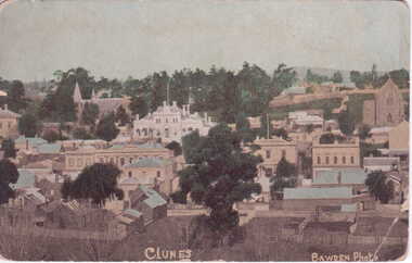
POSTCARD SENT TO MRS. L. MCLENNAN, QUEENSLAND.1 ORIGINAL POSTCARD - OVERVIEW OF CLUNES - FROM SCENIC DRIVE, SHOWING TOWN HALL, CLUB HOTEL ETC. .2 SEPIA COPY OF ABOVE PRINTED ON PHOTOGRAPHIC PAPER .3 COLOURED COPIES OF ABOVE POSTCARD REPRODUCED BY BAWDEN PHOTO .4 black and white photograph1. On reverse of postcard addressed to; Mrs. L. McLennan, Olive Station, via Marlborough, Rockhampton - hand written message "Dear A., Lot is home have not seen here yet. I will write next week. hope G is better, Bear would like a trip, love from all Kit .3.4 On front of postcards in white printing; Clunes Bawden Photolocal history, document, postcard, clunes township -
 Rutherglen Historical Society
Image, Park Path Rutherglen 17, c1890
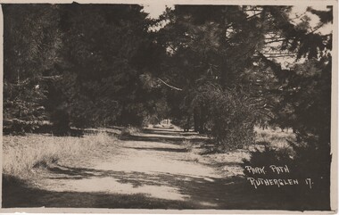
Path shown is on the western side of Lake King, Rutherglen. The pine trees have been replaced with river red gums.Black and white postcard photograph showing a path through and avenue of trees.Printed at bottom right of photo: "Park Path Rutherglen 17" Message written on back of card: "Dear Alban | Just a card to wish you the complements of the season. I've been so busy that I've not had time to write, so excuse this short note. Hoping you and yours are in the best of health as we are also. I am your affectionate cousin Olga"rutherglen park, lake king -
 Bendigo Historical Society Inc.
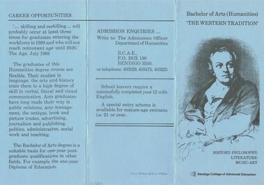
Document - BACHELOR OF ARTS (HUMANITIES), BENDIGO COLLEGE OF ADVANCED EDUCATION
Bachelor of Arts (Humanities), Bendigo College of Advanced Education. 'The Western Tradition' History-Philosophy-Literature-Music-Art. About The Course.. Course Content.. Training.. Career Opportunities.. Admission Enquiries .. Write to: The Admissions Officer Department of Humanities. B.C.A.E., PO Box 199, Bendigo 3550. or telephone: 403229, 403475, 403225. School leavers require a successfully completed year 12 with English. A special entry scheme is available for mature-age entrants i.e. 21 or over. Cover: William Blake by Phillips. 'skilling and reskilling. .. Will probably occur at least three times for graduates entering the workforce in 1989 and who will not reach retirement age until 2030.' The Age, July 1988.education, bendigo, bendigo college of advanced educati, bachelor of arts (humanities), bendigo college of advanced education. 'the western tradition' history-philosophy-literature-music-art content training career opportunities.. admissions officer department humanities. b.c.a.e., po box 199, bendigo school leavers completed year 12 with english. special entry scheme for mature-age entrants i.e. 21 or over. william blake by phillips. 'skilling and reskilling. graduates workforce in 1989 retirement age until 2030.' the age, july 1988. -
 Bendigo Historical Society Inc.
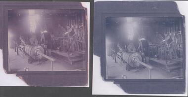
Photograph - Monument Hill Gold Mine Engine Room, 1930's, exact date unknown
The Monument Hill Gold Mine was at the corner of Old Violet Street and Olive Street. It operated until 1947. The shaft was capped, the poppet legs and mullock removed. A house now occupies the site. The Monument Hill Gold mine depth was over 1200 ft. The donor of the photograph is the grandson of Albert Dunstan, and he recalls that 'the mine was fully operational in the 1940's and I was often able to see my Grandfather at work and watched as men stepped into cages to be lowered to their awful occupation'. Donor's great, great grandfather was John Perry Dunstan, a well respected mine manager on the Bendigo goldfield.Two black and white copies of original photograph. Image shows Albert Ernest Dunstan working in the engine room of the Monument Hill Gold Mine, Bendigo. Albert is at the controls of the engine, lowering and raising the mining cage; he is leaning on the support railing around the elevated platform he is standing on. Letter accompanying images describes the donor's family connection to John Perry Dunstan and Albert Ernest Dunstan, he writes that ' the mine was fully operational in the 1940's and I was often able to see my Grandfather at work and watched as men stepped into cages to be lowered to their awful occupation. I was very surprised that today there is a home sitting above what was once a very deep mine'.monument hill gold mine, albert dunstan, old violet street, olive street, engine room, mining cage -
 Federation University Art Collection
La Perruque, 2018
Laresa KOSLOFF Laresa Kosloff makes performative videos, Super-8 films, hand-drawn animations, sculpture, installations and live performance works, all linked by an interest in the body and its agency within the everyday. Recurrent themes include humour and tension between received cultural values, individual agency and free will. La Perruque won the 2018 Guirguis New Art Prize. ‘Laresa is a worthy winner having been dedicated to her practice over many years and creating a work that is intelligently structured and steeped in satire, epitomising what we all either know or experience at work or in office life. By her clever collaging of characters, editing and story adaptation, Laresa has created an impressive fictional and insightful work that by way of its very construction cleverly illustrates and articulates aspects of Australian culture,’ (Shelley Hinton, Curator Federation University’s Post Office Gallery)A USB and a portable hard drive in a black archival box with a signed certificate. Her short film La Perruque is made entirely out of commercial stock footage, generic material produced for corporate advertising, which is strangely artificial, simplistic and loaded with images of success and productivity. Kosloff uses this footage to tell the tale of an office worker who is secretly trying to write a novel during work hours. The silent footage has been dubbed using voice actors and assembled into a story that subverts commercial representations of office life. The title refers to a French term that translates into 'wearing the wig', used to describe a situation of secretly working on personal projects during work time.guirguis new art prize, video -
 Ballarat Tramway Museum
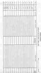
Document - Form/s, State Electricity Commission of Victoria (SECV), "Sign off cars at Depot - Week Days", Mar. 1970
Form used to provide information to the depot about defective trams when motormen signed off at the depot. Thought to be used in final months of the tramway system. Also used by Ray Hall as a sheet of paper to write out the details of No. 9 run for Sundays as a reference document.Duplicated typed form, S.163, titled "Sign off cars at Depot - Weekdays", for signing off defects in trams that Motorman signed off when signing off at the Depot in Wendouree Parade. Form made out for weekdays, has date/time in top right hand corner. Has Run Number and Time in pre-printed, then space for car number, defects, motorman's signature, repairs made and Foreman's Signature. Some runs detailed twice. On rear, Ray Hall has used the sheet to write out Sunday No. 9 run details, Mount Pleasant and Victoria St trips - gives sign on, meal and sign off times and notes that the trams pass at Pleasant St.trams, tramways, timetables, sec, ballarat, tramcars -
 Warrnambool and District Historical Society Inc.
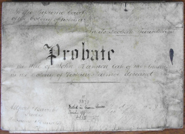
Document, John Hannon Probate 1874, 1875
This is the probate and will of John Hannon of the Anakies. John Hannon died in March 1874. Anakie is a small town between Geelong and Bacchus Marsh and the Anakies are three small hills in the nearby Brisbane Ranges National Park. Nothing is known of John Bannon except for the details in the will and probate. He was unable to read and write, signing his will with a cross and he was a small handholder having property valued at under £300. He left his estate to his wife Johanna and her family. The probate document is signed by R.W. Pohlman, Acting Master in EquityThis document is only of interest in that it came from a local Warrnambool legal office in Kepler Street. It originally came from Thomas Goodall, a legal clerk in the office of lawyer Ernest Chambers who passed it on to George Mackay, the lawyer in the forerunner firm of the legal firm of Mackay Taylor. The document came the buildings that previously housed the firm of Mackay Taylor. This is a piece of parchment folded in two and joined at the fold by a piece of green ribbon to which is attached a government seal (Supreme Court of the Colony of Victoria). The parchment is much discoloured and the seal is torn. The contents are handwritten in black ink. ‘Probate on the will of John Hannon, late of the Anakies, in the colony of Victoria, Farmer, deceased’john bannon, anakies, warrnambool -
Mission to Seafarers Victoria
Letter - Correspondence, 14/02/1952
Allan describes London following the death of King George VI. He witnessed the Proclamation of the Queen at the Royal Exchange. He writes "The Proclamation was read in four different parts of the city and about a hundred Lifeguards escorted the Royal carriages through the city." And ....."I also saw the procession from Kings Cross station to Westminister Hall when they brought the King back to London." He would have liked to walk past the coffin lying in state at Westminister Hall but the queue was three miles long and it took seven hours to get into the hall.Quinn CollectionA pale blue self-folding letter (0894.a1) headed 37 Elsham Road, London W 14 and dated 14/02/52. Letter is typed using a very small font. The print is faint and difficult to read. It is addressed to Mrs K Hayes, 14 Fitzroy Street, St Kilda, Victoria, Australia. There is no postmark. The return address is Allan Quinn, 37 Elsham Road, London W14.letters-from-abroad, allan quinn, alette andersen, death of king george vi, proclamation of queen elizabeth ii, london 1952 -
 Robin Boyd Foundation
Letter, G. R. Locke, G R Locke to Robin Boyd, 15.07.1952
The letter writer G. R. Locke has read Robin Boyd's newspaper articles on early public buildings and homes. This letter tells Boyd about the historic home "Auburn House", 4 Goodall St Hawthorn, established for Robert Hepburn with land purchased in 1856. It also tells of the confusion with neighbouring house "Auburn Lodge". Since Boyd writes on early Melbourne public buildings and homes, the writer is inviting Boyd to view the house. It is not known whether Robin Boyd took up the invitation. In 1960 it was included in the National Trust Register. -
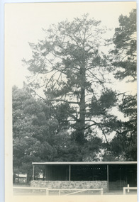 Mt Dandenong & District Historical Society Inc.
Photograph, Hand's Pine Tree in Kalorama Reserve
Kalorama Memorial Reserve was once the location of 'Mountain Grange', the property of Thomas and Eliza Hand. The pine tree pictured was reputedly planted by Mrs Eliza Hand in the 1880s. Thomas Hand died in 1888 when he was thrown from his horse on Inverness Road. The photograph was taken in 1974 and the pavilion pictured is no longer there. John Lundy-Clarke grew up in the Kalorama/Mt Dandenong area and later in life (1972-74) began to write a comprehensive history of the area working from an original settlement map in an effort to cover all areas.Black and white photograph showing a large pine tree behind a pavilion. Handwritten description on reverse by John Lundy-Clarke.Hand’s pine tree in Kalorama reserve. Planted 1874 approx. Pictured 14-3-73.kalorama memorial reserve, kalorama oval, mountain grange, thomas hand, eliza hand, pine tree, pavilion -
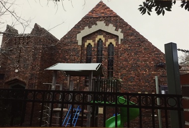 Kew Historical Society Inc
Photograph - Photographs, Former Baptist Church, Woodlands Avenue, Kew East, 2018, 2018
The former Baptist Church, at 8-12 Woodlands Avenue, Kew East, was nominated by the Society for protection as part of the Kew East Heritage Gap Study. W D Vaughan in his 'Kew's Civic History' (1960 writes that: "With the development of East Kew, local Baptists considered the establishment of a church was necessary. A block of land was purchased in Woodlands Avenue and the foundation stone of a new church was laid on August 8, 1931. A fine Sunday school has since been erected, and special emphasis has been given to providing activities for the young people of the church"Three colour photographs of the former Baptist Church in Woodlands Avenue, Kew East. The photographs are of the front and side of the clinker brick building. One of the photographs shows the foundation stone, laid by AH Lewis Esq, 8 August 1931.churches - kew (vic), baptist church - woodlands avenue - kew (vic) -
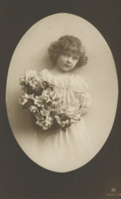 Lakes Entrance Historical Society
Postcard - Charles Sands WW1 AIF Correspondence, R4666/3A right corner, 1916 c
Sent from France by Charles Sands June 17/17 Dear Little Dorothy I suppose you have been wondering if I am ever going to write to you wee little Dorothy. I was so pleaseed to get the pretty card that you sent me it made me long to be back with you again and I think I will some day. I am pleased you have a lady school teacher. I will say goodbye now little Dorothy with best wishes from CharlieBlack and white photograph of little girl holding flowers, image in oval frame dark background on postcard Franceworld war 1914-1918, communications -
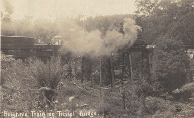 Emerald Museum & Nobelius Heritage Park
Photograph, Postcard, Belgrave Train on Trestle Bridge, 13/01/1914
Early postcard of Puffing Billy on trestle bridge Faded sepia photograph/postcard depicting Puffing Billy on Trestle BridgeFront: text, Belgrave Train on 'Tressel' Bridge Back: Handwritten text: 13/01/1914? Emerald - Dear Mother we are at Emerald, on our way to L. Pa? Everything is going well. Crarj/ys? are going Dande (Dandenong?) Father slept all night. Will write in a couple of days. Jesse's in good form stocking up provisions. No need to worry, Loving son Blair ?puffing billy, belgrave, whiteside -
 Warrnambool and District Historical Society Inc.
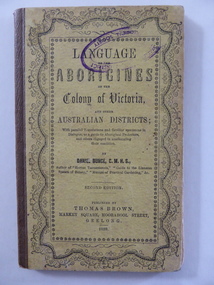
Book, Language of the Aborigines of the colony of Victoria, 1859
This is the second edition of a book published originally in 1851. It is an early work concerned with the recording of aboriginal languages and was published in Geelong. The author, Daniel Bunce (1813-1872) was a botanist who went on journeys with aborigines in Victoria in 1839 and later in 1846 joined Ludwig Leichhardt’s second expedition in his attempt to cross Australia from east to west. This was unsuccessful. Bunce’s experiences in 1839 and in 1846 enabled him to write his book on aboriginal languages. In 1858 Bunce became the Director of the Geelong Botanic Gardens and designed and planted out the gardens. No information has been found on Noel Hallowill. This book is of antiquarian interest as an early dictionary of aboriginal languages and as a book written by the botanist, Daniel Bunce. This is a hard cover book of 60 pages. The cover is yellow with black lettering. There is an ornamental border around the printing. There are two blue stamps of the Warrnambool and District Historical Society on the front cover and on the first page. The book is bound with brown tape. The book has a Preface, an Introduction and sections on the aboriginal languages in areas of Victoria and beyond. A copy of a letter from the explorer, Ludwig Leichhardt, is included at the end of the book. Stamp of ‘Noel Hallowill’ (name unclear) daniel bunce, aboriginal languages, ludwig leichhardt -
Mission to Seafarers Victoria
Letter - Correspondence, Allan Charles Quinn, 03/09/1949
Allan writes that having reached New York he has 'signed off' the 'Fenris'. "After ten months I'm a civilian again....". He describes the eighteen hour voyage from Boston to New York when they came through the Cape Cod Canal and Long Island Sound in New England past holiday homes, sailboats and launches. He mentions that, in New York, Bing Crosby's latest film is 'Top of the World', Ingrid Bergman is appearing in 'Under Capricorn' and that you can buy a 12" television for the equivalent of fifty pounds, a smaller one for twenty-six pounds. Quinn CollectionSingle-sided letter written on seven sheets of thin, blue unlined paper (0821.a1-0821.a7) dated 3/09/49 and headed New York. No envelope was found. The letter is from Allan to his mother.letters-from-abroad, quinn, 1949, new york -
Unions Ballarat
The forgotten rebels of Eureka, Wright, Clare, 2013
Clare Wright writes about the multitude of women who were at the Ballarat goldfields and the critical roles that they played in the goldfields and the Eureka Stockade. Contents Introduction : dust and rattling bones Part 1. Transitions 1. A virgin country 2. Deliverance 3. Crossing the line 4. The road Part 2. Transformations 5. The gold diggers on '54 6. Winners and losers 7. The winter of their discontent 8. Parting with my sex Part 3 : Transgressions 9. Burning down the house 10. High camp 11. Crossing the line (reprise) 12. Bloody Sunday. Relevant to Australian and Ballarat history and especially facts around the story of the Eureka Stockade.Paper; hardcover book. Front cover: blue and white Eureka flag background; white, fawn and blue lettering; sticker (The Stella Prize 2014 Shortlist).Front cover includes title and author's name; quotations from reviewers. Back cover: quotes from reviewers.btlc, ballarat trades hall, ballarat trades and labour council, eureka stockade, women in history, goldfields, gold miners, gold mining - ballarat, history -
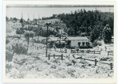 Mt Dandenong & District Historical Society Inc.
Photograph, View Up Valley At Kalorama
John Lundy-Clarke grew up in the Kalorama/Mt Dandenong area and later in life (1972-74) began to write a comprehensive history of the area working from an original settlement map in an effort to cover all areas. The building in the centre of the photograph is 'Kia-Ora' guest house. Situated on Barber’s Road, ‘Kia-Ora’ was built in 1912 by George Barber. It was later leased by a Mrs Pemberthy. “Kia-Ora’ was one of four places connected when the telephone was brought into the district in 1912. The other places were ‘Mountjoy’, ‘Cherry Farm’ and ‘Callum House’. ‘Kia-Ora’ was burnt down in 1924. Black and White copy of section of a Rose Series postcard. Shows view up the valley at Kalorama with a decorative building centre middle of photograph. Handwritten description by John Lundy-Clarke on reverse.View up valley at Kalorama from near junction of Barbers and Doughty’s Rds. “Kia Ora” guest house in centre. Paynter’s “Iona” top left with “Kalorama” to its right. About 1912. Rose Series copied by JLC 1973.kalorama, kalorama valley, john lundy-clarke, barbers road, george barber, kia-ora, guest house, iona -
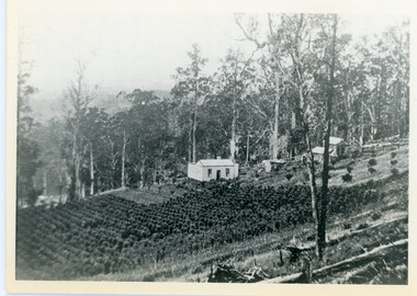 Mt Dandenong & District Historical Society Inc.
Photograph, Walker's LOT 2
Lot 2 was bought by Harry Walker in the early 1900s. Harry was married to Eva Hand, one of the six daughters of Thomas and Eliza Hand. Harry cleared the land and planted half with raspberries that remained productive until c1928. Harry's son William took over the property. The land was cut in half when the new CRB road went through in the early 1920s. John Lundy-Clarke grew up in the Kalorama/Mt Dandenong area and later in life (1972-74) began to write a comprehensive history of the area working from an original settlement map in an effort to cover all areas.Black and white photograph showing a single storey white house in the centre surrounded by crops. Handwritten description on reverse by John Lundy-Clarke.VIEW 1908 OVER LOT 2 SECTION 1 VILLAGE SETTLEMENT. TAKEN FROM RIDGE ROAD THEN MAIN ROAD FROM HALFWAY BETWEEN MOUNTJOY AND FALLS RD. CRB MAIN RD RUNS BEHIND WALKER’S HOUSE. The house seen in the vista among the tall trees beyond the raspberry patch is “Forest Edge” which was George Barber’s home when the picture was taken. The tall trees to the right of the vista were on Price’s LOT 18 and it was while cutting up one of these for firewood that a length of log weighing about ½ a ton got away downhill and leaped in one bounce over Barbers Road and Logan’s house – 1931.harry walker, william walker, eva hand, crb road, raspberries, kalorama