Showing 824 items
matching eastern victoria
-
 Greensborough Historical Society
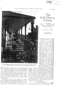
Article - Article, Journal, Kathleen McEwan, The Golf Clubs of Victoria: VI - Heidelberg and Eastern, by Kathleen McEwan, 01/06/ 1929
... The Golf Clubs of Victoria: VI - Heidelberg and Eastern, by... of Victoria: VI - Heidelberg and Eastern, by Kathleen McEwan Article ...Occupied by the Heidelberg Golf Club in 1928, the homestead, Bryn Teg, was built by R. T. Brown about 1849. This article, written in 1929, describes the building and its history in detail.4 p. black and white photocopy of article from Australian Home Beautiful, June 1, 1929, stapledheidelberg golf club, bryn teg, lower plenty -
 Greensborough Historical Society
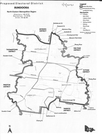
Map - Map (Copy), Electoral Boundaries Commission, Proposed electoral district: Bundoora, 01/07/2021
Proposed revised electoral boundaries for the electoral district of Bundoora (North-Eastern Metropolitan Region) as at 01/07/20211p. black and white copy of mapelectoral boundaries, bundoora - maps, victoria - parliament -
 Mission to Seafarers Victoria
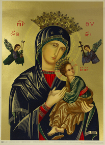
Print - Reproduction of a painting, Perpetual Succour
Discovered in the Chapel of St Peter when packing up for renovations. Probably a gift from an Eastern European crew member visiting the Mission TBC.Print of Eastern Orthodox style painting of Madonna and child on gold ground printed inscription lower edge of imageorthodox church, nativity, mary, jesus, crown, angel, artwork-paintings -
 Mission to Seafarers Victoria
Drawing - Artist sketch, Gerry Cummins & Jill Stehn Pty. Ltd, 1980
The window in this photograph was commissioned by the Sandringham Yacht Club in conjunction with a Masonic Lodge and work carried out by Gerry Cummins in 1980. In the background is the S.S. 'Kanimbla' built 1935, Belfast for McIlwraith McEacham and was the last large passenger ship built specifically for Australian owners. Designed to carry 400 passengers , she plied her trade around the Southern and Eastern Ports of Australia. In WW2 she was an armed merchant cruiser and served in Indian waters and escorted the 1st convoy out of the Singapore after the Japanese invasion. She later operated in the Pacific after the war and after repatriation duties she was decommissioned and subsequently sold to be renamed 'Oriental Queen' which eventually caught fire and sank. . The small yacht in the foreground refers to the Sandringham YC. Window measurements: 600mm x 900mmShows the link with Freemasonry.Sketch in pencil and ink on cream paper for an arched stained glass window depicting a yacht.Bottom left corner: Proposed Stained Glass Window, Mission to Seamen. (Scale: Full Size) Right Left corner: Gerry Cummingsfreemasons, st peter chapel, flinders street, mission to seafarers, gerry cummins, jill stehn, stained glass window, sandringham yacht club, hearts of oak lodge, yacht, symbols, square, compass, ss kanimbla -
 Mission to Seafarers Victoria
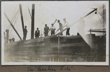
Photograph, The Eastern City
duncan album -
 Lorne Historical Society
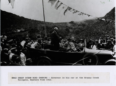
Photograph, Opening Great Ocean Road 1922
... G.O.R; Opening-1922; Governor of Victoria -1922; Grassy... of Victoria -1922; Grassy-Creek:; Eastern-View; Photograph of Governor ...Photograph of Governor of Victoria standing in his car at the Grassy Creek toll gate Eastern View 1922 at the opening of the Great Ocean Road g.o.r; opening-1922; governor of victoria -1922; grassy-creek:; eastern-view; -
 Mission to Seafarers Victoria
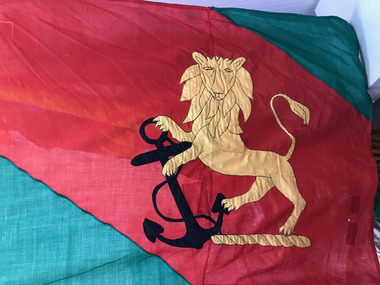
Flag - House flag, Eastern & Australian (E&A)
The first Seafarers Service was held on 23 October 1905 in the St Paul's Cathedral in London to celebrate the Centenary of the Battle of Trafalgar and the death of Vice-Admiral Horatio Nelson on 21 October 1805. Reverend Alfred Gurney Goldsmith launched the first Seafarers Service two years later and the first service was held on Sunday 10 November 1907. National and house flags are used during the annual Seafarers Service. Eastern and Australian Steam Ship Company, a small line which played a strong part in Australian maritime history, providing links from Australia (in particular Queensland) and New Zealand to South-east Asia from 1873 to 1983.The service continue to reflect the full range of the maritime activities in Australia. Representatives come from the Royal and Merchant Navies, the commercial world, shipping companies, mission and philanthropic societies, veterans’ associations, labour unions, youth and leisure organisations, but anyone is welcome to attend.Large green flag with crest of a gold lion rampant holding a gold fouled anchor on a red stripe.E & A written in black penflag, seafarers service, shipping company, e&a, eastern and australian, house flag -
 Mission to Seafarers Victoria
Flag - House flag, Eastern & Australian (E&A)
The first Seafarers Service was held on 23 October 1905 in the St Paul's Cathedral in London to celebrate the Centenary of the Battle of Trafalgar and the death of Vice-Admiral Horatio Nelson on 21 October 1805. Reverend Alfred Gurney Goldsmith launched the first Seafarers Service two years later and the first service was held on Sunday 10 November 1907. National and house flags are used during the annual Seafarers Service. Eastern and Australian Steam Ship Company, a small line which played a strong part in Australian maritime history, providing links from Australia (in particular Queensland) and New Zealand to South-east Asia from 1873 to 1983.The service continue to reflect the full range of the maritime activities in Australia. Representatives come from the Royal and Merchant Navies, the commercial world, shipping companies, mission and philanthropic societies, veterans’ associations, labour unions, youth and leisure organisations, but anyone is welcome to attend.Large green flag with crest of a gold lion rampant holding a black fouled anchor on a red stripe.E & A written in black penflag, seafarers service, shipping company, e&a, eastern and australian, house flag -
 Mission to Seafarers Victoria
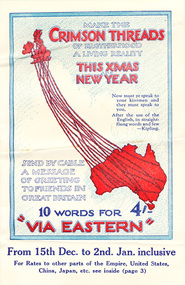
Letter - Telegram, Telegram to Lillie from Ted, 1928
The telegram was sent to Lillie Duncan shortly before Christmas, by one of the seafarers she met through her work with the Ladies Harbour Lights Guild. The brochure advertises seasonal rates on telegrams to ''all parts of the British empire and the United States of America''.The telegram is evidence that Lillie Duncan had personal contact with the seafarers she met through the Ladies Harbour Lights Gild. The brochure shows the importance put on the Christmas period, as well as the strong relationship between Australia and Great Britain.A telegram in three parts consisting of: Envelope, Brochure and Telegram.Post mark on envelope in top right hand corner: MELBOURNE/9/indecipherable/VICTORIA. Port mark on telegram on right hand side: EASTERN EXTENSION AUSTRALASIA indecipherable/MELBOURNE/23 DEC 1928/STATION.melbourne, christmas, advertisement, lillie-duncan, east-malvern, the-eastern-extension-australasia-china-telegraph-company, port said, ted, lhlg, lillie duncan -
![Sketch - Digital image, William Poulter's Bonnie Vale [sketch], 1925c](/media/collectors/4f729f5697f83e03086015b8/items/54d0485a2162f10e70db9490/item-media/54d0489e2162f10e70db9ed3/item-fit-380x285.jpg) Greensborough Historical Society
Greensborough Historical SocietySketch - Digital image, William Poulter's Bonnie Vale [sketch], 1925c
Copy of sketch of William Poulter's property "Bonnie Vale". William Poulter and his wife Mary arrived in Victoria in 1849 and settled in Greensborough in 1853, constructing "Bonnie Vale" soon after their arrival. The old house was completely destroyed by fire circa 1960. Bonnie Vale, if existent in modern times would have been found in south eastern centre of Poulter Reserve, over the Plenty River is the house property known as 'Blackjack' on 59 Hume Street.Greensborough pioneer family Digital copy of black and white sketch. -
 Greensborough Historical Society
Article, Batman Apple Tree, 11/12/2002
Details some versions of the history of the 'Batman Apple Tree'. Also the condition and lack of maintenance of the tree in 2002. Highlights Nillumbik Shire's ignorance of the existence of the tree; which is within one kilometre of the Nillumbik Shire Offices.It is possibly the oldest European planted tree in Victoria. It was planted as a young tree in 1841.A4 photocopies of 3 articles relating to the condition and origin of the "Batman Apple Tree", located on the eastern bank of the Plenty River, north of Greensborough.Blue pen annotations on one article.apples, john batman, robert whatmough, frederick nevin flintoff, plenty river, 1841, rome beauty, rymer apples, winter majetin, apollo parkways primary school -
 Halls Gap & Grampians Historical Society
Map - Coloured
Background on Bridle Path up Stony Creek Gorge Pre 1840 C. B. Hall, squatter on Mokepilly Run 1841-1842, first European to discover the Fyans Creek valley, the entrance of which became known as Hall's Gap. He later recorded that he followed a number of tracks which he assumed had been made by the Aboriginies and described one as "leading up a wild romantic glen and over on to the source of the Glenelg River". This could well have been the route taken up Stony Creek gorge by the first timber-cutters in this part of the Grampians to the saddle between the Wonderland and Mt. Difficult ranges known as Valley Gap 1850s/60s Timber cutters and shingle splitters were reported to be moving into the eastern side of the Grampians and by the mid 1860s there were a number of families connected to the supplying of timber to Pleasant Creek living in the "Hall's Gap ranges". John Wakeham, the first store owner in Pleasant Creek in 1854, established a timer-mill in upper Stony Creek Gorge in the late 1850s. Wakeham is credited for the clearing and levelling of the first bridle-path up the gorge. 1870s By the mid 1870s the track had been extended over Valley Gap to the Victoria Forest (the upper region of the Victoria Valley). McKeon's bullock team was known to have hauled red gum from the Valley to Stawell in the late 1870s and the 1880s. 1880s In 1887 an article in the Pleasant Creek news describes the Stony Creek Gorge track as "being a ledge alongside the mountain range, formed in the early days with the aid of earth and timber, along which the bullock teams used to travel to Horsham and plains of the Wimmera beyond." 1890s Gold was discovered in the catchment area of Stony Creek and by the end of the 1890s a new track was built from "near the junction of Fyan's and Stony Creeks, up the gorge to the diggings settlement. The mining Department had paid L300 for its construction and, when completed, the track was "three miles and 30 chains in length, the side cuttings at the narrowest part being 10 feet between" and "the watercourses which cross the track at various points" having been "filled up with rocks rolled down the sides of the hills, and consequently there can be no damage caused by bushfires which destroyed the former wooden bridges erected on the old track to Wakeham's saw-mill, the remains of which are still to be seen at the side of the diggings" The article goes on to further describe the track as one which "can with ease travel with a two horse conveyance either up or down" and that the workmen engaged in the construction of the track would be attending "a ball that night at McKeon's farm near the mouth of the gap to celebrate the successful completion of the undertaking". 1900s At what time the bridle path was extended beyond Valley Gap to the Wartook basin on the Mt. Difficult Range has not yet been determined. However, it is known that, by the turn of the century, people were travelling between Halls Gap and the caretakers' residence at Wartook Reservoir along what was now known as the "Bluff Road. Wartook's embankment had been constructed in 1887 and at that time there was already a track from Rosebrook Station homestead (near the present day Wartook Pottery) to the reservoir. Philip Rose owned both Rosebrook and Wartook Stations from the mid 1840s to the late 1850s and had regularly leased the Wartook basin to Cobb & Co. to rest horses there. 1920s Following the war of 1914-1918, tourism really took off in the Grampians, and Halls Gap rapidly grew. People would travel as far as they could on the many tracks then hike to the many lookouts being discovered by local tour guides. This led to the need for access across the range so that horse riders and the increasing number of vehicles could travel between Horsham and Halls Gap. To this end, the Bluff Road was improved and extended on 1929 and at its opening in March, 1930, by Lady Somers it was renamed the Mt. Victory Road.Map of Mt Victory Road and othersaccess routes, mt victory rd, bridle path, roads -
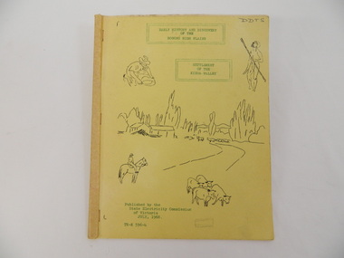 Kiewa Valley Historical Society
Book - Bogong High Plains x2, Early History and Discovery of the Bogong High Plains, 1968
The State Electricity Commission of Victoria constructed the Kiewa Hydro Electric Scheme in the north east of Victoria. Mr R.M. Duncan prepared the notes. He was a member of the S.E.C. Kiewa Branch from 1949 - 1966. This book was commissioned by the State Electricity Commission of Victoria. It consists of the early history of the Bogong High Plains and the origin of names of places and creeks in the area.This book was researched in 1968 by Mr R.M. Duncan who worked for the S.E.C. on the Kiewa Hydro Electric Scheme from 1949 to 1966. His sources were the Melbourne Public Library, the Victorian Historical Society, the North Eastern Victorian Historical Society and the Dept. of Crown Lands & Survey, Melbourne. The book is an accurate history of the Bogong High Plains given the available records at the time. Yellow cardboard covered book with black sketches and green print. 9 one-sided pages held together by 3 staples and taped over the staples. One - has sheets enclosed "The Three Floras of Bogong" and "General Geology of the Kiewa Area". 6 copies including 1 that is a photocopyDDTS hand written on front cover "Early History and Discovery / of the / Bogong High Plains" on cover top centre. "Settlement / of the / Kiewa-Valley" on cover towards the top slightly to the right. "Published by the / State Electricity Commission / of Victoria / July, 1968" on cover bottom left. "TR-K 596-4" on cover bottom left.bogong high plains. state electricity commission of victoria. kiewa. aborigines. kiewa valley. mullindollingong pastoral run. flora. geology -
 Victoria Police Museum
Police Stations (Apollo Bay)
Apollo Bay is a coastal town in southwestern Victoria. It is situated on the eastern side of Cape Otway, along the edge of the Barham River and on the Great Ocean Road, in the Colac Otway Shire. The original township was surveyed in 1853 and named Middleton. In 1881 the town was renamed Krambruk which was changed to Apollo Bay in 1898. The Krambruk Police Station was opened on 7 March 1888 in the Southern District on land opposite the site of the current Mechanics' Institute and changed its name to the Apollo Bay Police Station on 1 September 1990. It came under the Barwon District in 1948 and "Lima" Western District from 4 March 1990. In 1930 the police station was located to 29 Nelson Street. It was a seven-roomed weather-board dwelling on three-quarters of an acre of land. It consisted of six rooms of pine, lined and painted; one pantry; one bathroom and wash-house; one hall; one office and one W.C.. There was stabling for one horse and one cell for prisoners. It was staffed by one Mounted Constable. In the early 1970s land was acquired at 31 Nelson Street and a new police station was constructed. This was a three-roomed brick building with a cell block at the rear. By the time it closed in 2005 it had been extended twice. On 17 November 2006 the current Apollo Bay Police Station opened in its current location at 35a Nelson Street, on the corner of Cartwight Street). Outside the peak summer season, the station is open 16 hours per day and staffed by one sergeant and five other members. 3 black & white photos and 2 coloured photospolice stations; apollo bay police station -
 Victoria Police Museum
Police Stations (Ararat)
Ararat is a city in south-west Victoria, Australia, about 198 kilometres west of Melbourne, on the Western Highway on the eastern slopes of the Ararat Hills and Cemetery Creek valley between Victoria's Western District and the Wimmera. It is named after Mount Ararat 10 kilometres south-west of the town. A police station opened in Ararat in 1859, though there was a police presence in the area formerly known as Cathcart, Canton Lead and later Mount Ararat. In 1861 staff consisted of 1 Superintendent, 2 Mounted Constables, 1 Sergeant 2nd class, 1 Senior Constable, 8 Constables. The police reserve was on land bounded by Ligar Street, Barkley Street, Ingor Street and High Street. In 1930 the police station was described as a six-room brick dwelling with a slate roof, situated on one quarter acre of land. There was also a bathroom, wash-house, pantry, office, muster room and quarters for a single constable, stables with three stalls, and a lock-up consisting of two six-person cells. Later residences were located at 3 Ligar Street (brick veneer with a tile roof); 32A High Street (brick veneer with tile roof); and 3 Tobin Street (wood with an iron roof). A new, purpose built police station was opened in October 2010 at 77 Barkly Street. The Ararat Police District was reformed into the Wimmera Police District in 1870. Ararat Police Station became part of "R" (Glenelg) District in January 1948 and "M" (Highlands/Wimmera) District from March 1990. A list of police stationed at Ararat from 1903 - 1930 is available from the Victoria Police Museum8 photos comprising: 7 black & white photos 1 colour photopolice stations; ararat police station -
 Orbost & District Historical Society
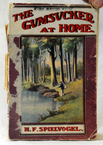
book, George Robertson & Co, The Gumsucker At Home, 1914?
Nathan Frederick Spielvogel (1874-1956), teacher, writer and historian, was born on 10 May 1874 at Ballarat, Victoria. as well as his stories he published a number of Books about the history of Ballarat. Spielvogel taught at Orbost for at least a year and this book reflects that time. Spielvogel was a teacher, writer and historian. As a country schoolteacher, he traveled widely in the eastern Australian outback and also made a journey to London. Spielvogel gained distinction as one of the only Australian Jewish writers of his time. Many of his early books were best-sellers. He has an association with the history of Orbost having spent a year as a teacher at Orbost. The book also has an association with J.W. Bird an early auctioneer and estate agent in Orbost.A small 124 pp book with a pink, white and red cover with an illustration of a fisherman at a river. It is titled "The Gumsucker at Home" by N. F. Spielvogel.inside cover - J. W. Birdspielvogel-nathan the-gumsucker-at-home australian-literature -
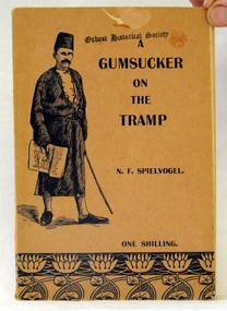 Orbost & District Historical Society
book, George Robertson & Co Prop. Ltd, A Gumsucker on the Tramp, 1910?
This is the second edition. The letters were written by Nathan Spielvogel, a country school teacher for the 'Dimboola Banner'. It cost one shilling. Nathan Frederick Spielvogel (1874-1956), teacher, writer and historian, was born on 10 May 1874 at Ballarat, Victoria. As well as his stories he published a number of books about the history of Ballarat. Spielvogel was a teacher, writer and historian. As a country schoolteacher, he traveled widely in the eastern Australian outback and also made a journey to London. Spielvogel gained distinction as one of the only Australian Jewish writers of his time. Many of his early books were best-sellers. He has an association with the history of Orbost having spent a year as a teacher at Orbost.A small brown soft covered booklet of 108 pages, titled "A Gumsucker on the Tramp" in black print. On the front cover is an illustration of It contains an Australian's impression during a lengthy trip to Europe.literature spielvogel-nathan gumsucker-on-the-tramp -
 Ringwood and District Historical Society
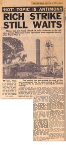
Newspaper - clipping, Eastern Post Gazette, Rich Strike Still Awaits, 4-Feb-70
Antimony became a hot topic in 1970 as the price of the metal rose. The site of the mine was "pegged" again.Newspaper clipping dated 4 February 1970 (page 3) showing buildings at the old antimony mine in Ringwood, Victoria. Photo provided by Mr J.K. McCaskill. -
 Ringwood and District Historical Society
Photograph, Edwin G. Adamson A.R.P.S, Back grocery, corner Adelaide St Ringwood 1963 (Eastland Litigation Photo) (2 views), May 1963
This series of SS0380 photos are part of the "Eastland Litigation" launched in 1962 by the Whitehorse Traders Co-operative Association (WTCA), against the Ringwood Council's Interim Development Order of 1960. WTCA sought "orders from the Supreme Court of Victoria that the planning scheme was invalid" - See "The Eastland Litigation" chapter in "From Horse Shoes to High Heels - Ringwood Shopping Centre and Eastland 1858-2008" by Richard Carter, Bounce Books 2009.Written on back of photograph 2826-2, 'Back grocery, corner Adelaide St.' Stamped on back, 'Edwin G. Adamson... [and samped] In the Supreme Court 13 Aug 1963'. On back of 2826-1 (similar photo at different time): Photo of the shop and dwelling ordered to be demolished - north-eastern corner of Adelaide St and Maroondah Hwy. -
 Orbost & District Historical Society
May 1900
This is a photograph of the original Orbost / Snowy River Bridge , a suspension bridge which opened in 1893. It has been taken when the Snowy River was in flood. It is similar to other photographs held in The State Library, Victoria. The Snowy River Mail and Tambo and Croajingolong Gazette Sat 12 Aug 1893 records the opening of this bridge as "the most important public event that has yet been commemorated in Eastern ......The Messrs McLeod, with whom the first settlement of this district is generally associated, took up their residence on the eastern bank of the Snowy River about the year 1841 or 42. The late Mr W. Roadknight and Mr T. T. Stirling took possession of the territory on the western side of the Snowy about 35 years ago. During the occupation of the country by cattle owners, very little progress was made in the way of roads and bridges, and except to the hardy and lexperienced bushman, it might have been generally regarded as inaccessible. About the year 1877, however, the late Mr James Robertson eldest son of Mr James Robertson, of Lochend farm, selected land now occupied by his father, about four miles from Orbost on the west bank of the river, Mr John Cameron visited the. district shortly after a .tour of inspection and returned later with his brothers, James and Alick Gameron, but found that during their absence Mr Ernest Watt had found his way on the scene and pegged out a selection, thus anticipating the advent of the Camerons by about 12 hours. We understand that a Mr Kidd, who selected the property now occupied by Mr W. J. Ross, at Pumpkin Point, was one of the earliest batch of settlors.........."This is a pictorial record of an early bridge across the Snowy River at Orbost.A black / white photograph of a suspension bridge with flood waters below the bridge.orbost-bridge suspension-bridge snowy-river -
 Orbost & District Historical Society
black and photograph / postcard, 1.4.1908
This postcard was sent to Annie Gilbert (Mrs John Gilbert) of Tullagoota, Orbost. It was written by "Grace", probably her sister, Grace Cameron Annie Gilbert was the daughter of John Cameron who selected the first land on the Snowy River flats. This is a photograph of the original Orbost / Snowy River Bridge , a suspension bridge which opened in 1893. It has been taken when the Snowy River was in flood. It is similar to other photographs held in The State Library, Victoria. The Snowy River Mail and Tambo and Croajingolong Gazette Sat 12 Aug 1893 records the opening of this bridge as "the most important public event that has yet been commemorated in Eastern ......The Messrs McLeod, with whom the first settlement of this district is generally associated, took up their residence on the eastern bank of the Snowy River about the year 1841 or 42. The late Mr W. Roadknight and Mr T. T. Stirling took possession of the territory on the western side of the Snowy about 35 years ago. During the occupation of the country by cattle owners, very little progress was made in the way of roads and bridges, and except to the hardy and lexperienced bushman, it might have been generally regarded as inaccessible. About the year 1877, however, the late Mr James Robertson eldest son of Mr James Robertson, of Lochend farm, selected land now occupied by his father, about four miles from Orbost on the west bank of the river, Mr John Cameron visited the. district shortly after a .tour of inspection and returned later with his brothers, James and Alick Gameron, but found that during their absence Mr Ernest Watt had found his way on the scene and pegged out a selection, thus anticipating the advent of the Camerons by about 12 hours. We understand that a Mr Kidd, who selected the property now occupied by Mr W. J. Ross, at Pumpkin Point, was one of the earliest batch of settlers.........."This item is associated with Annie Gilbert (nee Cameron) reported to have been the first white girl to be born in Orbost. It is a pictorial record of the suspension bridge over the Snowy River which has since been replaced twice.A faded black / white postcard of a bridge across a river. There are cattle in the river and the banks are tree-covered.on back - a hand-written letter addressed to Mrs J. Gilbert Tullagoota Orbost.cameron-annie suspension-bridge-orbost snowy-river-orbost -
 Ringwood and District Historical Society
Pamphlet, G.A. Green, Auction Sale Brochure - Garden Farms Estate, Ringwood, Victoria - 1919, 1919
Multi-fold brochure advertising public auction of one-acre, 2-acre, 5-acre and 8-acre allotments in Ringwood and Bayswater on Saturday 12th April, 1919. Brochure includes terms of sale, description of subdivision features and local facilities, and photographic images of the area.Subdivison includes Canterbury Road Heathmont, Armstrong Road Heathmont, Armstrong Road Bayswater, Bungalook Road Heathmont, Bungalook Road Bayswater, and Orchard Road Bayswater. Road shown as Bayswater Road to Bayswater became Mountain Highway Bayswater. Vendor: H.E.B.Armstrong, Auctioneers: Coghill & Haughton, 79 Swanston Street Melbourne, Telephone Central 2793, in conjunction with J.B. McAlpin, Ringwood, Opposite Station, Telephone Ringwood 7. (Map) Woodcock & McCormack, Civil Engineers Architects & Surveyors, 430 Little Collins Street, Melbourne, Phone 3241 Central. MOST OF THE MONEY COMES OUT OF THE LAND. And more money can be obtained from anb acre of fruit than from an acre of any other produce. But you do not have to grow fruit on Garden Farms Estate. You can go in for - Outer Suburban Home - Market Garden - Orchard - Pig Raising - Poultry Farm - Small Dairy Farm - Small Fruits - Floral Culture - Scent and Bee Farm - Or just for a Week-end Home. RINGWOOD - THE PLACE TO LIVE. The Beautiful Ringwood District has so many natural attractions, that half a Land Agent's work is done in just showing a prospective buyer round and about. Ringwood has a pull of its own that attracts folk, proved beyond doubt by its rapid development within the last decade (spite the war). First, it is high and healthy, picturesque and undulating, convenient of access, sufficiently close to the Metropolis for City and Business folk to live at Ringwood. Its development is solid, because most of its people are industrious husbandmen, real producers, who have turned idle hills into smiling gardens. These are the kind of real people to live amongst; ones who wear out their spades. The rapidly-developing town has excellent Stores, Trade and Repair Shops Churches, Banks, Telephone Exchange, Weekly General Market, Cool Stores, and good Private and State Schools, etc.; is Electrically lit, has Metropolitan Water Supply, and generally provides so that practically all shopping can be done locally. WHY RINGWOOD MUST GROW. Ringwood is a great centre and must be a greater. Two rapidly-developing railways junction here. The passengers from Ringwood Station cityward, in one year, number 250,000. Ringwood will be the terminus of the Outer Suburban Electric Eastern Railway. Its natural boundaries are the River Yarra on the North, Dandenong Creek on the South, the popular town of Croydon on the East, and the suburb of Mitcham on the West. This is a large territory that is steadily being converted from intense culture, and then it might be called (as regards its gardens) "The Devon Territory of Victoria." ARMSTRONG ROAD. This new road traverses Garden Farms Estate from its northern boundary on the main Canterbury Road, across Dandenong Creek, to its southern boundary on the main Bayswater Road, and will provide a long-desired additional link of communication between Bayswater and Ringwood. The 1-acre building sites on Bayswater Road are within 8 minutes' walk of the Bayswater Railway Station, and the Canterbury Road frontages are only 1-1/2 miles from Ringwood Station, and 1/2 mile from the Railway Station site of Canterbury Road; therefore, the whole Estate is easy of access and there should be a large demand for land so favourably placed. (Image) Cultivation Field - Potatoes on Lot 28 (Image) Picture of Bayswater Creek Flats. (Image) View from "Korumbeen" where Mr. Armstrong lived on Garden Farms Estate. Estate outlined in white ring. (Image) Site of New Bridge over Dandenong Creek. (Image) On one of the timbered lots adjoining railway. (Image) This Dandenong Creek traveres the Estate. (Image) Main Fern Tree Gully Line bisects the Estate. -
 Orbost & District Historical Society
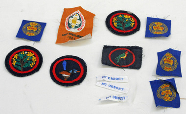
badges, 1950's -1960's
These badges are unused and were possibly available for those guides who took part in the various camps or became new members. they were designed to sew on to the guide uniforms or blankets. Nancye Wallace (nee Warren) was a Guide leader.Established in 1910, Girl Guiding is now one of the largest all female organisations in the world. It is designed for girls, young and not-so-young women to join and enjoy a program of informal learning, opportunities, fun, personal development and friendship. (ref. Girl Guides Victoria). These badges used by an Orbost local reflects the history of that organisation in Orbost.Twelve cloth badges. They are unused Girl Guide badges. two are round with a black background and inside a red circle is a wattle tree. One is round with a variegated fairy wren inside a red circle. One is rectangular with an eastern rosella inside a red circle. There are four smaller square shaped badges (cut from a strip) with gold, and red print on a blue background - " 1910 Girl Guides Jubilee 1960". One is a rectangular Camp Kindamindi badge and there are three rectangular strips, white with blue print "1st Orbost".badges-cloth girl-guides -
 Orbost & District Historical Society
book, Vic Roads Centenary 1913 -2013, 2013
The publication, VicRoads Centenary: Keeping Victorians Connected for 100 Years, looks at the people and projects that define VicRoads’ history. Written by current and former VicRoads’ employees, the publication details the organisation’s portfolio of major projects, which includes the Great Ocean Road, Hume Highway and Eastern Freeway. Other sections report on Victoria’s world-first road safety initiatives, VicRoads’ use of technology and sustainability measures. (ref VicRoads) This item is one of several books donated by David Jellie at a presentation to Orbost Historical Society. He was a contributor to the book and was the engineer for the Snowy River Bridge (Princes Highway) at Orbost 1974-1976.This book is a useful reference tool on the history of road construction in Victoria including East Gippsland.A thick, bound paperback book, titled "VicRoads Centenary Keeping Victorians Connected for 100 Years". On the front cover is a black/white photograph of two men working on a road. One has a pick. The book contains the history of VicRoads, photographs, maps and advertisements. Some are b/w. Others are coloured.vicroads book roads snowy-river-bridge jellie-david -
 Orbost & District Historical Society
railways envelope, C 1980's
This item was used by Victorian Railways 1970's/1980's. It was used at Orbost Railway Station for the consignment of timber from Orbost to Westall.. Westall was a major timber-receiving depot near Dandenong, Victoria. Westall railway station is located on the Pakenham and Cranbourne lines in Victoria, Australia. It serves the south-eastern Melbourne suburb of Clayton South, opening on 6 February 1951. Westall station was opened as a workers only platform on 16 October 1954. It was provided for the adjacent Martin & King railway coachbuilding factory. The station was opened to the public on 1 June 1959 when all trains on the line began stopping there. The Bairnsdale-Orbost railway was opened in 1916 to serve the agricultural and timber industry. Because of the decline in traffic and heavy operating costs, the line was finally closed in August, 1987. Orbost Railway Station was opened on Monday 10 April 1916 as the terminus of the Orbost railway line, and closed in 1987. The station was located on the west side of the Snowy River despite the town of Orbost being on the east side of the river, in order to save on the costs of a bridge over the river, which at the time had highly variable levels. This item is associated with the history of the Orbost-Bairnsdale railway line and therefore reflects the role that the rail line played in the social and economic history of Orbost.An unused brown/buff coloured goods/freight consignment envelope used by Victorian Railways, this one for timber from Orbost to Westall. It is DL size.2497-78 VICTORIAN RAILWAYS G.F 63 From ORBOST to WESTALL MASS Tonnes kg Vehicle No Contents TIMBER Consignee Date orbost-bairnsdale-railway westall -
 Fire Services Museum of Victoria
Fire Engine - Pump - Melba, MFB Pierce-Arrow Heavy Pumper, 1911 (exact)
... Fire Services Museum of Victoria Former Eastern Hill Fire ...Unique vehicle fabricated by MFB from chassis of Dame Nellie Melba's salon carUnique vehicle, critical for large fire extinguishing, fully restoredPierce-Arrow MFB Heavy Pumper salon car manufactured 1911 Petrol Engine - Straight 6, 48HP, Kelly & Lewis pump, centrifugal, 400 gpm, 5 inputs, 2 outlets, rear mounted PTO driven Converted by MFB from Salon Car into heavy pumper in 1919 Out of service with MFB in 1933Registration No 16658, 1911 Melba Pump, Pierce-Arrow,melbourne, red, melba, heavy pumper, mfb, pierce arrow, vehicle, dame nellie melba, fire engine, solid tyre -
 Fire Services Museum of Victoria
Book - Bendigo Fire Brigade 100 Years, Bendigo Fire Brigade 100 Years, 1899 - 1999, 1999; Year published
... Fire Services Museum of Victoria Former Eastern Hill Fire ...Book, by George ELLIS, detailing the history of Bendigo Fire Brigade, - blue cover, stapled paperback, A4 size"copy" "FSMV 5522" on page 1, brigade, bendigo, fire, 100, years, ellis -
Fire Services Museum of Victoria
Fire Mark Sept 2010, MFESB, MFB Fire Mark Magazine Sept 2010, 9:MMMM, 2010 (exact)
... Fire Services Museum of Victoria Former Eastern Hill Fire ...MFB Fire Mark Magazine Sept 2010mfb, fire mark -
 Fire Services Museum of Victoria
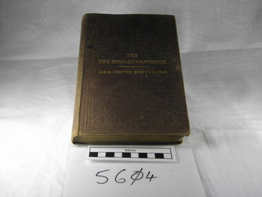
Book - The Fire Brigade Handbook, The Fire Brigade Handbook by James Compton Merryweather
... Fire Services Museum of Victoria Former Eastern Hill Fire ...Personal copy of Captain James Kelly of the Prahran City Fire Brigade. Captain Kelly was killed at a fire in Melbourne in 1890. He was an advocate of brigade consoldiation and personal developmentHistoric: This book is a very early (1888) instruction manual and was the personal copy of Captain James Kelly of the Prahran City Fire Brigade. Published in England by James Compton Merryweather, of the Merryweather fire engine and equipment manufacturing company. It is the only known copy in MelbourneThe Fire Brigade Handbook by James Compton Merryweatherfire-brigade-organization capt-james-kelly prahran-city-fire-brigade merryweather fire-brigade-training fire-brigade-equipment -
 Fire Services Museum of Victoria
3 Pump
... Fire Services Museum of Victoria Former Eastern Hill Fire ...