Showing 516 items matching "strait"
-
 Port Melbourne Historical & Preservation Society
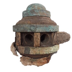
Photograph - SS Nairana, C.1951
The SS Nairana was launched 1915 by William Denny & Brothers in Dumbarton Scotland the 3,402 ton steamer was requisitioned by the Royal Navy and served during WW1. In 1922 she was transferred to Tasmanian Steamers and, apart from again being requisitioned for war service in WW2, was used as a Bass Strait ferry until 1948. The Nairana was blown ashore onto Port Melbourne beach during a severe gale on 19 February 1951. After salvage what remained of the wreck was blown up in 1954. B & W aerial photograph of SS Nairana and Port Melbourne foreshore. Ship's outline can be seen on far right side of photograp.ss nairana, transport - shipping -
 City of Greater Bendigo - Civic Collection
Badge - Referendum Badge, Yes, 2023
On the 14th of October 2023, Australians were asked to vote on a proposal to change the wording in the constitution 'To recognise the First Peoples of Australia by establishing an Aboriginal and Torres Strait Islander Voice.’ Only 39.9 per cent of legal votes were in favour of this change, and there was not a majority in any of the six Australian States (there was a majority, however, in the Australian Capital Territory). On the 26th June, 2023 Councillors with the The City of Greater Bendigo discussed their position on The Voice to Parliament and decided to support the Yes campaign while pledging to provide information on both sides of the debate to residents. Cr Margaret O’Rourke introduced the motion and spoke at length about the importance for Council to adopt the recommendation. “Recognising the Aboriginal and Torres Strait Islander voice in the constitution ensures that Indigenous Australians have a direct and meaningful role in shaping policies and laws that impact them'. Several Councillors voiced their concern over whether the City could formally support one side of the debate, while seeking to provide neutral information saying that it did not pass the commonsense test. These badges were collected at an event at Rosalind Park on the 27th of September, 2023 attended by Linda Burney, Minister for Indigenous Australians who addressed the crowd.Large badges with YES printed in centre. city of greater bendigo reconcilliation, dja dja wurrung -
 Bendigo Military Museum
Map - MAPS, EAST TIMOR, US Govt et al, 1975 - 1976
1. This is a coloured map. It's scale is 1.250,000 - called a jpoint operations graphic. It covers the North side of East Timor. Dili is in the centre. Its shows 4 Islands to the north of Timor. It shows Savu Fea, Ombai Strait, Wetar Strait. On bottom left of map it shows Batheade and the start of the New Border. Map - Series 159. Sheet 5C- 51-4. Edition 3-GSGS. 2. This is a coloured map. Its scale is 1.250,000 called a joint Operations Graphic. It manly covers West Timor. It shows Savu Sea in North and Timor Sea on south side. Series 1501. Sheet SC 51.7. Edition 3-GSGS. 3. This a coloured map. It's scale is 1.250,000. Joint operations graphic. This map shows the south side of East Timor and the Timor Sea. This map shows a highlighted New border. The major towns on South coast are KAMFNASA, BETANO. Map series 1501. Sheet SC 51-8. Edition 3 GSGS.1. Has highlighted "7 BSG" on coast. All maps show East Timor border highlighted in pink.east timor, maps, interfet -
 Orbost & District Historical Society
black and white photograph, February 1971
This photograph was taken near the Snowy River Bridge on the the old Princes Highway in Orbost, near the caravan park. The 1971 flood was the the worst flood on record. At Jarrahmond it was at least 11 metres and up to one and a half kilometres wide on the flats causing enormous damage to the flood plain. Records say that "The brown floodwater stain in Bass Strait could be seen from passing airliners." Considerable damage was done to railway infrastructure, roads and farms. More information from the APRIL, 2008 newsletter by John Phillips. (see orbosthistory.com.au)This is pictorial evidence of a significant local event. Floods have been an integral part of Orbost's history for hundreds of years.A black / white photograph of debris, fallen power lines, a tree across the highway and floodwaters across the road.on front at bottom - handwritten in upper case print - " 1971 FLOOD PRINCES HIGHWAY NEAR SNOWY BRIDGE"floods-orbost-1971 -
 Orbost & District Historical Society
black and white photograph, February 1971
This photograph is an aerial view of the township of Orbost taken by the Bairnsdale Advertiser newspaper. It was taken from the northern end of the town. The 1971 flood was the the worst flood on record. At Jarrahmond it was at least 11 metres and up to one and a half kilometres wide on the flats causing enormous damage to the flood plain. Records say that "The brown floodwater stain in Bass Strait could be seen from passing airliners." Considerable damage was done to railway infrastructure, roads and farms. More information from the APRIL, 2008 newsletter by John Phillips. (see orbosthistory.com.au)This is a pictorial record of a significant event in the history of Orbost,A black / white aerial photograph of a township with floodwaters in the background.on back - "Note main current through the lagoon 1971."orbost-floods-1971 bairnsdale-advertiser orbost-township -
 Queenscliffe Maritime Museum
Uniform - Beret
On the evening of February 17, 1960, 74 peacetime commandos in army boats set off on a training exercise from Point Lonsdale to Point Nepean, simulating a raid. The weather was calm at Point Lonsdale on a midweek evening 50 years ago, but 50 years ago weather forecasts were not yet reliable. By nightfall a massive storm came through and all hell broke loose. Soon, three young Victorians were dead and more than 70 others were rescued from huge seas in Bass Strait.Green commando beret similar to ones worn by commandos involved in Rip Disaster of 1960Commando beret (green) with unit insigniaUnit insignia: "Strike Swiftly"commandos, beret -
 Queenscliffe Maritime Museum
Functional object - Fishermans Cottage, Built in 1870/1880 for Thomas and Anna Ikin
This low-lying northern-most tip of Queenscliff saw its physical origins in 1863 with allotments let to a burgeoning fishing community previously accommodated on the site of the current railway station and whose construction in 1879 necessitated eviction. Among this community, Chinese fishermen are thought to be of the first international settlers. The success of the fishermen’s settlement was due in part to commercial trading prospects the railway afforded and the size of catch available to those fishing in Bass Strait. Salmon, snapper and particularly barracouta led to the success of the local industry.Original Fishermans Cottage previously located at Swan Bay end of Bridge Street Queenscliff. Timber - Weatherboardfishermen's cottage, fishermen's flat, queenscliff -
 Orbost & District Historical Society
black and white photograph, February, 1971
This photograph shows the floodwaters during the 1971 flood at Orbost. The two mahogany trees in the photograph stopped the Snowy River from changing its course. The 1971 flood was the the worst flood on record. At Jarrahmond it was at least 11 metres and up to one and a half kilometres wide on the flats causing enormous damage to the flood plain. Records say that "The brown floodwater stain in Bass Strait could be seen from passing airliners." Considerable damage was done to railway infrastructure, roads and farms. More information from the APRIL, 2008 newsletter by John Phillips. (see orbosthistory.com.au)This is a pictorial record of a significant event in the history of floods in Orbost.A black / white photograph of raging floodwaters at the bottom of the Orbost township.orbost-flood-1971 -
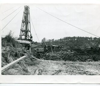 Orbost & District Historical Society
black and white photographs, 15th February 1971
The 1971 flood was the the worst flood on record. At Jarrahmond it was at least 11 metres and up to one and a half kilometres wide on the flats causing enormous damage to the flood plain. Records say that "The brown floodwater stain in Bass Strait could be seen from passing airliners." Considerable damage was done to railway infrastructure, roads and farms. More information from the APRIL, 2008 newsletter by John Phillips. (see orbosthistory.com.au) The railway line was destroyed and was not expected to be opened for a fortnight. Orbost was cut off by 50 square miles of Snowy River floodwater. These photographs are pictorial records of the 1971 floods which was a significant event in the history of Orbost. They are also associated with the East Gippsland Railway.Three black / white photographs of flood debris and flood waters near a railway line. 3102.l has a pile driver 3102.2 shows a gap in the viaduct and 3102.3 shows men with a tractor cleaning up the debris,3102.1 - on back - "1971 FLOOD REPAIRS TO ORBOST RAILWAY VIADUCT - 15th February 1971. Donated by Audrey Van Den Berg VRH 3693" 3102.2 - on back - " DAMAGE TO RAILWAY VIADUCT ACCUMULATED DEBRIS" 3102.3 - on back - "DAMAGE TO RAILWAY VIADUCT AT ORBOST. CLEAN UP BEGINS"orbost-flood-1971 orbost-viaduct-flood-damage orbost-railway -
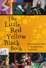 Victorian Aboriginal Corporation for Languages
Book, Bruce Pascoe, The little red yellow black book : an introduction to Indigenous Australia, 2008
The Little Red Yellow Black Book is an accessible and highly illustrated pocket-sized guide. It's an invaluable introduction to Australia's rich Aboriginal and Torres Strait Islander histories and culture. It takes a non-chronological approach and is written from an Indigenous viewpoint. The themes that emerge are the importance of identity, and adaptation and continuity. If you want to read stories the media don't tell you, mini-essays on famous as well as everyday individuals and organisations will provide insights into a range of Australian Indigenous experiences.maps, b&w photographs, colour photographsindigenous history, culture, art, sport, health, education, employment, reconciliation, resistance, governance -
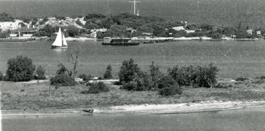 Lakes Entrance Historical Society
Photograph - Carpentertown, 1920c
Copied from copy in J Whadcoat collectionBlack and white photograph showing P W D cottage on left and other Works buildings on dune at the entrance to Gippsland Lakes from the ocean - Bass Strait. View shows flagstaff on top of dune and flagstaff jetty in lake - Cunninghame Arm. Small sailing boat on left and other small craft on shoreline. Section of Bullock Island with vegetation, one telegraph pole and one dead tree on island. Shoreline of North arm in foreground. Lakes Entrance Victoriajetties, waterways, settlement, historic site, boats and boating -
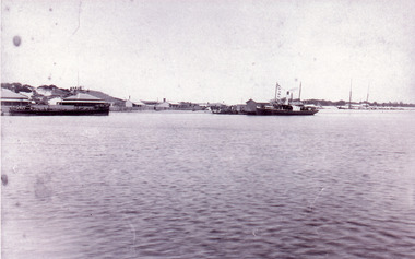 Lakes Entrance Historical Society
Photograph - New Works, 1890c
Three copies -Sepia photograph showing dunes, houses and Works buildings and boats at the entrance to Gippsland Lakes from ocean - Bass Strait. Photo shows two PWD houses on left and small school building, plus other Works buildings. Flagstaff on dune above houses. Large barge on left in front of houses. Large passenger steamer at New Works wharf with people waiting, has flags and bunting, two masted ketch on right of rock groynes. Lakes Entrance Victoriajetties, boats and boating, settlement, historic site -
 Flagstaff Hill Maritime Museum and Village
Functional object - Ship's Wheel
This wooden ship's wheel originally had eight spokes but four are no longer in their sockets. One of the spokes has been shaped. Both sides of the wheel have a brass cap over the centre of the hub, covering the wooden hub. The wood is split and cracked, and parts of it have small holes, a sign of being affected by the sea worm. Thick encrustations are on parts of the wheel, showing that it has been on the sea bed for quite some time. The donor is a Warrnambool resident. Years ago he was cray fishing at King Island, which is in Bass Strait, northwest of Tasmania. His craypot got stuck in a reef so a diver helped him by retrieving the craypot for him. While the diver was underwater he also stumbled across the ship's wheel, which he gave to the donor. The Bass Strait is a very narrow route that was difficult and dangerous to navigate in the early 19th century, before good maps, communications and lighthouses were installed. The area, including King Island, is the graveyard of many ships that almost made it to their destination of Melbourne along Australia's treacherous coastline. Around King Island alone, many ships and lives were lost. There is no information about the history of this ship's wheel. Its condition shows that the item has been under the water for a long time. However, there is no evidence that it came from a shipwreck. It could even have been an old ship that could have been scuttled or destroyed as it was no longer useful. The wheel is significant as a sign of shipping around King Island. It is part of the island's history, and of maritime history. It is an example of an item manufactured by hand.Ship's wheel; segment of a wooden ship's wheel. It once had eight spokes but only portions of four spokes remain. The outer centres of the hub and the reinforcing bands around the hub are brass. The wheel is heavily encrusted in parts. It was recovered from an unknown shipwreck in the waters of King Island.great ocean road, warrnambool, shipwreck artefact, artefact, ship's wheel, ship's wheel segment, portion of a ship's wheel, flagstaff hill, maritime museum, maritime village, flagstaff hill divers, marine technology, navigation, steering wheel, eight spoke wheel, king island, craypot, diver -
 Royal Australian and New Zealand College of Obstetricians & Gynaecologists (RANZCOG)
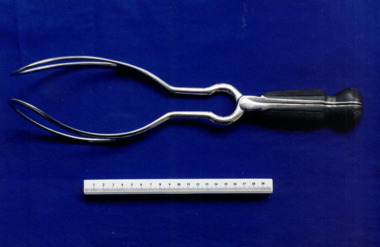
Barnes-type obstetrical forceps, Evans & Co., London
The '24' inscribed on the handle is a theatre number for instrument identification. Invented by British obstetrician Robert Barnes (1817-1907), these forceps were designed to "enable delivery from the superior strait and from above the brim in cephalo-pelvic disproportion." One of Barnes' aims with this design "was to reduce the incidence of craniotomy, because the Caesarean operation was at this time a desperate last resort." (Source: Forster, F M C. (1971), Robert Barnes and His Obstetric Forceps. Australian and New Zealand Journal of Obstetrics and Gynaecology, 11: 139-147.) With the addition of William Neville's axis-traction handle (invented in 1886), a variation of these forceps known as the Neville-Barnes forceps gained widespread popularity.Set of metal forceps, consisting of two nickel plated blades with bakelite handles. Inscribed 'EVANS & CO./LONDON'.Theatre mark "24" inscribed on handle of both blades.obstetric delivery -
 City of Ballarat
Artwork, other - Public Artwork, Deanne Gilson, Murrup Laarr by Deanne Gilson, 2019
Murrup Laarr translates as 'Ancestral Stones' in Wadawurrung. This artwork by Dr Deanne Gilson is located in the North Gardens Indigenous Sculpture Park. The park is a significant project for the City of Ballarat and features works by Aboriginal and Torres Strait Islander artists, celebrating the richness and diversity of culture and telling important cultural stories. Dr Deanne Gilson is a Wadawarrung Traditional Custodian and established artist. She installed the first artwork commissioned by the City of Ballarat for the Sculpture Park in early 2019. Murrup Laarr is a contemporary artwork consisting of a traditionally-built stone hut in the middle of a circle of basalt standing stones, marked with ceramic plates reflecting the stories and symbols of dreaming, memory, ceremony.The artwork is of aesthetic and cultural, social and spiritual significance to the people of Ballarat and to Wadawurrung peopleA traditional hut made from river stone and stacked rocks, with the hut surrounded by large basalt rocks with plaques featuring unique designs on stoneware plates imbedded into them. Murrup Laarr (Ancestral Stones), 2019 / By Deanne Gilson / Wadawurrung people have always used stones to mark places of ceremony and important business. The stones are the holders of memory and knowledge, Country and Spirit. They mark the cosmos and seasons. They follow the sun, marking the summer and winter solstice, important dates for planting and harvesting and telling stories of past, present and future. / The stones are alive and still present. Murrup Laar has been created using local basalt stones to tell Wadawurrung stories of dreaming, memory and ceremony. / “Creating Murrup Laarr (Ancestral Stones) at this time has placed Aboriginal people and practices back on Country and created a place to tell our stories. I am very honoured to have had this opportunity. An Aboriginal stone circle existed in Ballarat pre-colonisation; by putting back what was lost throughout colonisation I pay homage to my ancestors, past, present and emerging”/ – Deanne Gilson, March 2019 murrup laarr, wadawurrung -
Federation University Historical Collection
Costume, Federation University, Indigenous Uni Games Polo Shirt, Approx 2019?
National Indigenous Tertiary Education Student Games (NITESG) began in 1996. Now referred to as Indigenous Nationals, the event is a week-long multisport competition for indigenous student-athletes. The annual event aims to bring together athletes from universities across Australia to compete in a variety of sports and ultimately crown one university team the champion of the games. Indigenous Nationals seeks to also acknowledge the heritage and history of the participating athletes. This new synthetic shirt (still with tags attached) has short sleeves, a collar and three white buttons set in a placket at the neckline. The colour ranges from mid blue at the top to a dark blue with spots at the bottom. On the front is printed the FedUni logo on the left breast and on the right side is printed Indigenous Uni Games and the Aboriginal and Torres Strait crossed flags at the breast and below is a design and a platypus. The same design is repeated on the left sleeve and on the right sleeve is a logo for the Central Highlands Local Aboriginal Network. The number 28 is printed on the back.Makers brand is stamped on the inside back neck.federation university, indigenous uni games, indigenous nationals, central highlands local aboriginal network, polo shirt -
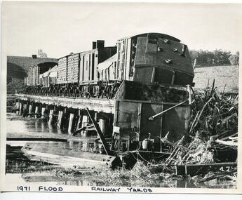 Orbost & District Historical Society
black and white photograph, February 1971
The 1971 flood was the the worst flood on record. At Jarrahmond it was at least 11 metres and up to one and a half kilometres wide on the flats causing enormous damage to the flood plain. Records say that "The brown floodwater stain in Bass Strait could be seen from passing airliners." Considerable damage was done to railway infrastructure, roads and farms. More information from the APRIL, 2008 newsletter by John Phillips. (see orbosthistory.com.au) The railway line was destroyed and was not expected to be opened for a fortnight. Orbost was cut off by 50 square miles of Snowy River floodwater. This train was being shunted across the viaduct when waters smashed through washing away several trucks sending the crew running for their lives.This is pictorial evidence of a significant local event. It is connected to the history of the railway in East Gippsland.A large black / white photograph of flooded railway yards with a train engine stranded on a small section of track surrounded by water and debris.on front - "1971 Flood, Railway Yards"floods-1971-orbost orbost-railway natural-disasters-orbost -
 Waverley RSL Sub Branch
Plaque H.M.A.S. Perth, H.M.A.S. Perth
HMAS Perth (D29), a modified Leander-class light cruiser. Commissioned into the Royal Navy as HMS Amphion in 1936, she was sold to the RAN three years later. The ship served until 1 March 1942, when she was sunk during the Battle of Sunda Strait. HMAS Perth (D 38), the lead ship of the Perth-class guided missile destroyers. Built as a Charles F. Adams-class destroyer derivative for the RAN and commissioned in 1965, the ship served until decommissioning in 1999. She was sunk as a dive wreck off the coast of Albany, Western Australia, in 2001. HMAS Perth (FFH 157), an Anzac-class frigate commissioned in 2006 and active as of 2012Wooden Plaque 15cm x 13cm with insignia of H.M.A.S. Perth H.M.A.S. Perth -
 Ringwood and District Historical Society
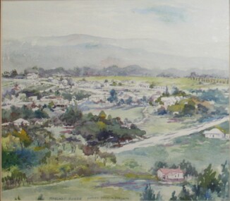
Painting, Margaret Robbie, "Temporary Accommodation, Heatherdale" - Water colour on paper by Margaret Robbie, circa 1950s
"Margaret Robbie was another of the local painters who came late to art or combined it with a quite different occupation. Her grandparents, John Shaw and Margaret (Byers), went to Hobart in 1855 but then crossed the Strait and settled in Kyenton where they remained until 1918. Margaret was the issue of the marriage of Mary Shaw and Robbie. She spent a considerable time overseas for the YWCA, including a period as its General Secretary in Toronto, Canada, and worked in the Middle East during World War 2. Margaret Robbie made her garage in Ringwood Street into a flat-cum-studio-cum-gallery for her painting activities when she was not caring for her sister and an elderly aunt." - Hugh Anderson - Ringwood, Place of Many Eagles [p.218].Painting with cardboard border in glass-fronted frame.Sticker on back of frame - "Ringwood Framing Gallery, 233 Whitehorse Road Ringwood, Phone 8704930" -
 Ringwood and District Historical Society
Painting, Margaret Robbie, Bush scene near East Ringwood sports oval, 1952 - Water colour on paper by Margaret Robbie, 1952
"Margaret Robbie was another of the local painters who came late to art or combined it with a quite different occupation. Her grandparents, John Shaw and Margaret (Byers), went to Hobart in 1855 but then crossed the Strait and settled in Kyenton where they remained until 1918. Margaret was the issue of the marriage of Mary Shaw and Robbie. She spent a considerable time overseas for the YWCA, including a period as its General Secretary in Toronto, Canada, and worked in the Middle East during World War 2. Margaret Robbie made her garage in Ringwood Street into a flat-cum-studio-cum-gallery for her painting activities when she was not caring for her sister and an elderly aunt." - Hugh Anderson - Ringwood, Place of Many Eagles [p.218].Painting with cardboard border in glass-fronted frame.Sticker on back of frame - "Ringwood Framing Gallery, 233 Whitehorse Road Ringwood, Phone 8704930" -
 Ringwood and District Historical Society
Painting, Margaret Robbie, "Dandenongs From Wantirna" - Water colour on paper by Margaret Robbie, circa 1950s
"Margaret Robbie was another of the local painters who came late to art or combined it with a quite different occupation. Her grandparents, John Shaw and Margaret (Byers), went to Hobart in 1855 but then crossed the Strait and settled in Kyenton where they remained until 1918. Margaret was the issue of the marriage of Mary Shaw and Robbie. She spent a considerable time overseas for the YWCA, including a period as its General Secretary in Toronto, Canada, and worked in the Middle East during World War 2. Margaret Robbie made her garage in Ringwood Street into a flat-cum-studio-cum-gallery for her painting activities when she was not caring for her sister and an elderly aunt." - Hugh Anderson - Ringwood, Place of Many Eagles [p.218].Painting in glass-fronted frame. -
 Ringwood and District Historical Society
Painting, Margaret Robbie, "View from Loughnan's Hill" (Ringwood) - Water colour on paper by Margaret Robbie, circa 1950s
"Margaret Robbie was another of the local painters who came late to art or combined it with a quite different occupation. Her grandparents, John Shaw and Margaret (Byers), went to Hobart in 1855 but then crossed the Strait and settled in Kyenton where they remained until 1918. Margaret was the issue of the marriage of Mary Shaw and Robbie. She spent a considerable time overseas for the YWCA, including a period as its General Secretary in Toronto, Canada, and worked in the Middle East during World War 2. Margaret Robbie made her garage in Ringwood Street into a flat-cum-studio-cum-gallery for her painting activities when she was not caring for her sister and an elderly aunt." - Hugh Anderson - Ringwood, Place of Many Eagles [p.218].Painting with cardboard border in glass-fronted frame.Inscription along lower edge of painting - "Margaret Robbie, copied from a postcard", and sticker on back of frame - "Ringwood Framing Gallery, 233 Whitehorse Road Ringwood, Phone 8704930" -
Port Melbourne Historical & Preservation Society
Film - Video Recording - Digital, Bruce Gooley, Men and Ships Driven by the Wind, 27 Sep 2022
Bruce GOOLEY is a graduate of Melbourne University and a researcher, presenter and self-published author with a special interest in maritime history. He is a volunteer tutor at the Hawthorn University of the Third Age (U3A). He has presented over 120 one and a half hour illustrated maritime history talks there, and has also presented to Provis and Historical Societies, and has documented these talks in book format. Bruce was a member of the Mornington Yacht Club for more than 50 years and owned and raced yachts in Port Phillip Bay, and Bass Strait, and has crewed on yachts racing to Vanuatu and around the State of Hawaii and cruising in the Beagle Channel. He is also a member of the Melbourne Maritime Heritage Network and he has presented several papers to them.Digital video recording of PMHPS meeting held on 27 September 2022. Bruce GOOLEY presents "Men and Ships Driven by the Wind"bruce gooley, transport - shipping -
 Yarra City Council
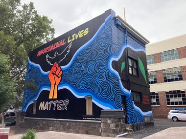
Artwork, other - Mural, Ky-ya Nicholson-Ward, Aboriginal Lives Matter, 2021
"The fist references the Black Lives Matter movement and also represents the strength of Indigenous peoples all over the world and symbolises solidarity and justice for everyone affected by systematic racism. Bunjil (wedge-tailed eagle) is flying high on the building. He is the creator spirit for Wurundjeri people who looks over us and protects us. Bunjil represents healing and power to our people. The blue circles and lines represent revival and waterways; in particular, they depict the Birrarung (Yarra River), which is very significant for the Wurundjeri people. Our people are known as the Manna Gum people. The leaves in the artwork highlight Wurundjeri people and their Country. These leaves also represent the cleansing of negative spirits. The Manna Gum leaf is also an important symbolic offering in our traditional Welcome to Country ceremony. Leaves are offered to visitors as they are granted safe passage through our land. They are made welcome to everything from the tops of the trees to the roots of the earth. We ask that they take care of the land, plants and animals and to respect the protocols and rules of the Traditional Owners whilst on our Country."In 2020 Council declared its support for the global Black Lives Matter (BLM) movement. In consultation with Yarra City Council's Yana Ngargna advisory group a motion was prepared and passed unanimously by all Councillors. A number of actions were generated from this decision; one of which was for Council to commission a large-scale mural that aligned with the movement. Emerging artist Ky-ya Nicholson-Ward, a proud Wurundjeri, Dja Dja Wurrung, Nguarai Illam-Wurrung, German and Irish woman, created the mural installed on a building in Peel Street Park, Collingwood. Selected by Council's Yana Ngargna, Black Lives Matter Working Group the artwork identifies the cultural importance of the local area to the Wurundjeri Woi Wurrung people as the Traditional Owners. With a strong focus on Aboriginal identity the mural outlines the local context of the Black Lives Matter movement, which is connected to racism, policing of Aboriginal and Torres Strait Islander peoples and associated deaths in custody. The artwork acknowledges the ongoing challenges faced by Aboriginal community members and their struggle to survive white systems, policies and institutions. Ky-ya's mural tells the story of Aboriginal resilience, strength and self-determination; and will support the process of healing. It is a celebration of the local Aboriginal and Torres Strait Islander community; the significant Aboriginal history of Fitzroy, Collingwood and surrounds; and community's continuing cultural connection to the area. Importantly, this artwork provides a platform to educate a broader audience about the local context of the Black Lives Matter movement and Aboriginal deaths in custody. The mural will activate this site, enliven the area, promote inclusion, incite conversation and contribute to the creative capital of this locale. A welcoming environment for Aboriginal and non-Aboriginal communities.Aboriginal Lives Matter Ky-ya Nicholson WardOn a black background a hand fist (strength, solidarity and justice) is placed at the centre of the building; Bunjil (wedge-tailed eagle) is depicted flying high on the building; blue circles and lines represent revival and waterways (Birrarung-Yarra River) and the leaves in the artwork highlight Wurundjeri people (cleansing of spirit and welcome to Country)The artist name 'Ky-ya Nicholson Ward' painted in white, low right of the wall facing into Peel Street Park. black lives matter (blm) movement, wurundjeri woi wurrung, bunjil, identity, birrarung, country -
 Queenscliffe Maritime Museum
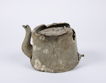
Domestic object - Teapot
In 1940, German minefields were laid in east and west Bass Strait which quickly claimed merchant ships Cambridge (British) and the City of Rayville (American). HMAS Goorangai had finished mine sweeping duties and after resupply was crossing from Queenscliff to Point Nepean to seek better anchorage due to impending bad weather. At around 20:30 on the 20th of November 1940 the 10,400-ton MV Duntroon was transiting the South Channel on her way to Sydney from Perth via Melbourne carrying 65 passengers and general and perishable cargo. It struck HMAS Goorangai forward of the funnel on the port side and cut her in two. At about 20:45 HMAS Goorangai sank in less than a minute resulting in the loss of her whole ship’s company, a complement of 24 officers and sailors.HMAS Goorangai was the first Royal Australian Navy (RAN) ship lost in WWII, the first RAN surface ship lost in wartime, and the first RAN surface ship lost with all hands. A memorial cairn was erected at Queenscliff in 1981 and a service of commemoration is held there every year.A severely damaged and corroded aluminium teapot recovered from the wreck of HMAS Goorangaihmas goorangai, wwii, collision at sea -
 Flagstaff Hill Maritime Museum and Village
Book, The Logbooks of The Lady Nelson, 1915
This hardcover book, The logbooks of the 'Lady Nelson' : with the journal of her first commander, Lieutenant James Grant, R.N., by Ida Lee (Mrs Charles Bruce Marriott) was published over 100 years after the Lady Nelson arrived in Australia to navigate and survey this ‘new colony’. Included in the book are sixteen charts and illustrations from the originals in the Admiralty Library, showing the surveyed land and water. The transcribed Contents, below, summarise the trips of the Lady Nelson during this time. Book’s Content PLUS text of the Chart of ‘Part of Bass Strait’ - Chapter 1: The Lady Nelson built with centreboards. Her voyage to Sydney under James Grant. The first ship to pass through Bass Strait. - Chapter 2: Returns to explore the Strait. Her visits to Jervis Bay and to Western Port in 1801 - Chapter 3: Colonel Paterson and Lieutenant Grant survey Hunter River - Chapter 4: Murray appointed commander of the Lady Nelson. His voyage to Norfolk Island. - Chapter 5: Murray’s exploration of Bass Strait. - Chapter 6: Discovery of Port Phillip. - Chapter 7: The Lady Nelson in company with HMS Investigator examines the North-Eastern shores of Australia. - Chapter 8: The French ships in Bass Strait. The founding of Hobart. - Chapter 9: Symons succeeds Curtoys as commander of the Lady Nelson. His voyages to Tasmania, Port Phillip and New Zealand. - Chapter 10: The Lady Nelson in Tasmania. The founding of Port Dalrymple. - Chapter 11: The Estramina is brought to Sydney. The Lady Nelson visits Norfolk Island and Port Dalrymple. - Chapter 12: Tippahee and his four sons are conveyed to New Zealand in the Lady Nelson. - Chapter 13: The Lady Nelson accompanies HMS Tamar to Melville Island. - Chapter 14: The loss of the Lady Nelson Text included with the ‘Chart of Bass Strait’ … “Part of Bass Strait, including the discoveries made by Acting Lieut. J. Murray, commander of His Majesty’s armed surveying vessel Lady Nelson, between November 1801 and March 1802. By command of His Excellency Governor King.” “This chart, which bears Murray’s autograph, shows his explorations of Western Port, Port Phillip and King Island. It should be noted that Flinders Island is named Grand Capuchin. This is one of the charts referred to as "unfortunately missing” in the Historical Records of N.S. Wales, vol. iv. P. 764” The story of the Lady Nelson In 1798 the British Admiralty ordered a cutter of 60 tons to be built along the design of the armed cutter Trial that was developed by Captain John Schanck, with three sliding keels or centreboards that could be individually raised and lowered, for use on the River Thames. The new cutter was to be named Lady Nelson. Philip Gidley King, prior to taking up his appointment as third Governor of the colony of New South Wales, was in England at the time of the Lady Nelson’s fit-out and was aware of the need for such a ship for survey work in the colony in New South Wales. He convinced Captain Schanck, the Commissioner of Transport in England, to construct and rig the Lady Nelson as a brig rather than a cutter, keeping the feature of the three sliding keels, which would be very useful for mapping in shallow waters. The new Lady Nelson was launched at Deptford, England on the River Thames in November 1798, with the official commission to discover and survey the unknown parts of the coast of New Holland (Australia) and establish British sovereignty over the continent. The Lady Nelson sailed from Portsmouth, England on March 1800 under the command of Lieutenant James Grant. She carried an armament of two original and four extra brass carronade carriage guns and set sail as part of a convoy heading to Port Jackson, in New South Wales, New Holland. After a while she continued to sail on her own. Her journey was troubled with problems at times; damaged and broken keels, troublesome crew and leaking topsides between the waterline and the deck due to poor seals. She arrived at the Cape of Good Hope in July and waited for the winter to pass to avoid the strong winds of the ‘Roaring Forties’. While at the Cape, Grant received a despatch to travel to Port Jackson via the newly discovered Bass Strait, rather than the usual route via the tip of Van Diemen’s Land (Tasmania). This also gave him the opportunity to survey the strait on the way. He departed the Cape in October and in December he made his first sighting of New Holland near Mount Gambier in what is now South Australia. A report by Ecclestone in 2012, ‘The Early Charting of Victoria’s Coastline’, mentions that Grant charted and named Capes Banks and Northumberland, and sighted inland hills that he named Mt Gambier and Mt Schanck, the latter after the designer of his ship. Grant then reached the south-western shores of what is now Victoria on 3-4 December 1800, and from Cape Bridgewater he examined the coast eastward to Cape Patton. Although he had not continuously sighted the coast in the vicinity of Port Fairy and Warrnambool, the western part of Victoria became known as Grant’s Land. The Lady Nelson continued eastward and passed through Bass Strait, becoming the first vessel to reach the east coast of New Holland from the west, and arrived at her destination of Port Jackson later in December 1800. Grant, in the Lady Nelson, then left Port Jackson and began survey work. He discovered Port Phillip on Victoria’s coast and explored King Island, he helped establish the first European settlement in Tasmania on the Derwent River, and Port Dalrymple, Newcastle and Port Macquarie. He made several trips from Norfolk Island to Hobart Town. Governor Macquarie sailed on with him to Van Diemen’s Land for a tour of inspection in 1811. Grant helped establish the first settlement on Melville Island in Northern Australia. The Lady Nelson was used to transport cargo, civilians and convicts and to source pigs from Timor. In February 1825 the Lady Nelson sailed again for Timor and never returned. One report said that “Every soul on board, we regret to state, was cruelly massacred, and the hull of the vessel was seen some time after with the name painted on her stern.” The hull was sighted on the island of Babar, which is almost 200 kilometres east of Timor. This particular copy of the book ... This item is from the ‘Pattison Collection’, a collection of books and records that was originally owned by the Warrnambool Mechanics’ Institute, which was founded in Warrnambool in 1853. By 1886 the Warrnambool Mechanics’ Institute (WMI) had grown to have a Library, Museum and Fine Arts Gallery, with a collection of “… choice productions of art, and valuable specimens in almost every branch and many wonderful national curiosities are now to be seen there, including historic relics of the town and district.” It later included a School of Design. Although it was very well patronised, the lack of financial support led the WMI in 1911 to ask the City Council to take it over. In 1935 Ralph Pattison was appointed as City Librarian to establish and organise the Warrnambool Library as it was then called. When the WMI building was pulled down in 1963 a new civic building was erected on the site and the new Warrnambool Library, on behalf of the City Council, took over all the holdings of the WMI. At this time some of the items were separated and identified as the ‘Pattison Collection’, named after Ralph Pattison. Eventually the components of the WMI were distributed from the Warrnambool Library to various places, including the Art Gallery, Historical Society and Flagstaff Hill. Later some were even distributed to other regional branches of Corangamite Regional Library and passed to and fro. It is difficult now to trace just where all of the items have ended up. The books at Flagstaff Hill Maritime Village generally display stamps and markings from Pattison as well as a variety of other institutions including the Mechanics’ Institute itself. RALPH ERIC PATTISON Ralph Eric Pattison was born in Rockhampton, Queensland, in 1891. He married Maude Swan from Warrnambool in 1920 and they set up home in Warrnambool. In 1935 Pattison accepted a position as City Librarian for the Warrnambool City Council. His huge challenge was to make a functional library within two rooms of the Mechanics’ Institute. He tirelessly cleaned, cleared and sorted a disarrayed collection of old books, jars of preserved specimens and other items reserved for exhibition in the city’s museum. He developed and updated the library with a wide variety of books for all tastes, including reference books for students; a difficult task to fulfil during the years following the Depression. He converted all of the lower area of the building into a library, reference room and reading room for members and the public. The books were sorted and stored using a cataloguing and card index system that he had developed himself. He also prepared the upper floor of the building and established the Art Gallery and later the Museum, a place to exhibit the many old relics that had been stored for years for this purpose. One of the treasures he found was a beautiful ancient clock, which he repaired, restored and enjoyed using in his office during the years of his service there. Ralph Pattison was described as “a meticulous gentleman whose punctuality, floorless courtesy and distinctive neat dress were hallmarks of his character, and ‘his’ clock controlled his daily routine, and his opening and closing of the library’s large heavy doors to the minute.” Pattison took leave during 1942 to 1945 to serve in the Royal Australian Navy, Volunteer Reserve as Lieutenant. A few years later he converted one of the Museum’s rooms into a Children’s Library, stocking it with suitable books for the younger generation. This was an instant success. In the 1950’s he had the honour of being appointed to the Victorian Library Board and received more inspiration from the monthly conferences in Melbourne. He was sadly retired in 1959 after over 23 years of service, due to the fact that he had gone over the working age of council officers. However he continued to take a very keen interest in the continual development of the Library until his death in 1969 This book about the logbooks of the Lady Nelson is locally significant for its association with the brig Lady Nelson, in which Lt. James Grant made the first documented European discovery of the area later known as Warrnambool in December 1800. This book is also nationally significant for its association with Grant in the Lady Nelson being the first to sail from west to east through Bass Strait, opening up a shorter, faster route to the colony of Port Jackson rather than going all the way south around Van Diemen’s Land. The book is nationally significant for its contents of the logbooks of the journeys of the Lady Nelson under various commanders and the copies of the charts created from the surveyed information and the new land of Australia was discovered. This book is also significant for its association with the full-size non-sailing replica of the Lady Nelson from Mount Gambier’s visitor centre, which was restored by Flagstaff Hill’s Master Boat Builder in Warrnambool in 2012, and with a ship mode of the Lady Nelson in our Collection The Pattison Collection, along with other items at Flagstaff Hill Maritime Village, was originally part of the Warrnambool Mechanics' Institute’s collection. The Warrnambool Mechanics’ Institute Collection is primarily significant in its totality, rather than for the individual objects it contains. Its contents are highly representative of the development of Mechanics' Institute libraries across Australia, particularly Victoria. A diversity of publications and themes has been amassed, and these provide clues to our understanding of the nature of and changes in the reading habits of Victorians from the 1850s to the middle of the 20th century. The collection also highlights the Warrnambool community’s commitment to the Mechanics’ Institute, reading, literacy and learning in the regions, and proves that access to knowledge was not impeded by distance. These items help to provide a more complete picture of our community’s ideals and aspirations. The Warrnambool Mechanics Institute book collection has historical and social significance for its strong association with the Mechanics Institute movement and the important role it played in the intellectual, cultural and social development of people throughout the latter part of the nineteenth century and the early twentieth century. The collection of books is a rare example of an early lending library and its significance is enhanced by the survival of an original collection of many volumes. The Warrnambool Mechanics' Institute’s publication collection is of both local and state significance. The Logbooks of The Lady Nelson Author: Ida Lee ( Mrs Charles Bruce Marriott) Publisher: Grafton & Co Date: 1915Label on spine with typed text RA 910.994 LEE Inside front cover has a sticker that reads Warrnambool Mechanics Institute and Free Library shipwrecked-coast, flagstaff-hill, warrnambool, flagstaff-hill-maritime-museum, maritime-museum, shipwreck-coast, flagstaff-hill-maritime-village, shipwrecked-artefact, book, warrnambool library, warrnambool mechanics’ institute, warrnambool city librarian, mechanics’ institute library, victorian library board, warrnambool books and records, warrnambool children’s library, great ocean road, the logbooks of the lady nelson, ida lee, mrs charles bruce marriott, captain john schanck, sliding keels or centreboards, lady nelson, british brig hms lady nelson, lieutennant james grant, bass strait discovery, surveying king island and port phillip bay, philip gidley king, survey map -
 Seaworks Maritime Museum
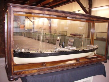
Shipbuilders model, SS ARGUS (1889-1907) - Steel steamship built by Palmers & Co., at Newcastle on Tyne for Archibald Currie & Partners, Melbourne, SS Argus, 1889-1907
Steel screw steamer launched 1889 at Newcastle on Tyne by Palmers & Co., built for Archibald Currie and Partners - the Currie Line of Melbourne. Gross tonnage: 2,792, Length: 99.06m (325'). Width: 12.3m (40.3'). Triple expansion steam engines producing 363 nhp. Avge speed 11 knots. Coal consumption 26 ½ tons per 24 hours. Steel hull, one funnel, two masts, barque rig. • 1889: Argus launched. Worked in the Australia to India trade, passengers, goods and horses. • 1891 July: While taking coal from Newcastle to Singapore, ran onto sunken rock in Gaspar Strait (in Indonesia). Watertight bulkheads held, got to Singapore, was repaired for two months, 60,000 Straits dollars (about £12,000). • 1895 July: While taking 400 horses to Colombo, ran onto reef near Somerset, North Queensland. holed, water in two compartments. 400 tons coal jettisoned, finally got off in spring tides. • 1901 Feb: During Boer War took Victorian contingent, 5th Mounted Rifles, fromMelbourne to Durban and Cape Town, with 500 horses. • 1901 Dec: Took horses for Boer War from Brisbane to Durban. • 1903 31 July: Leaving Sydney for Calcutta with 86 horses, 20 passengers including the Sultan of Johore, was rammed by the incoming steamer Mildura (on the wrong side of the channel). Argus's side plating was cut from deck to below waterline, had to be beached on Goat Island to prevent sinking. Refloated 2 August and repaired. • 1905: Argus sold to the Japanese shipping company, Osaka Shosen Kaisha. Renamed Giran Maru. • 1907 11 Sept: Wrecked in Soya Strait, between Hokkaido & Sakhalin Island.Built for Archibald Currie & Partners, Melbourne. Carried passengers between Australia and India and between western and eastern Australia.Large ship builder's model in glass case -
 Ruyton Girls' School
Magazine, Ruyton Girls' School, The Ruytonian, 1952
**This publication contains an image of Aboriginal and/or Torres Strait Islander children who may now be deceased.** In July 1909, a modest 12-page booklet was put together by members of the fledgling Old Ruytonians Association (ORA) and distributed to the Ruyton Girls' School community. It was one of their first projects, and their aim was to nurture continuing interest in the School among former and current students. They named it "The Ruytonian." At first, The Ruytonian was produced twice yearly, and always bore a plain cover with a simple name banner. Initially, it was the work of volunteer editors from the ORA, but in 1913 they handed the publication over to the first student editors, Esther Gibson and Lucy Tickell. Since that time, the style and content of The Ruytonian has continuously evolved. The biggest shifts occurred in 1942 when it transitioned to a yearly publication, and in 1969 when it moved to a larger A4 format with a cover image specifically selected for that year.The record has strong historic significance as it pertains to the fourth oldest girls' school in Victoria, Australia. Ruyton was founded in 1878 in the Bulleen Road, Kew, home of newly widowed Mrs Charlotte Anderson (now High Street South). Due to the age of the record dating back to 1952, we can infer it is one of the few remaining complete, intact and original examples of The Ruytonian from this period. Therefore, it can be considered an outstanding representation of its type, and is a reference example for research in early Victorian school history. The record's significance is further enhanced by its exceptionally well-documented provenance, having remained the property of Ruyton Girls' School since its production.Colour publication with a blue cover and printed on papyrus coloured paper. 55 pages.Front Cover: THE / RUYTONIAN / RECTE ET FIDELITER / DECEMBER, 1952 /ruyton girls' school, the ruytonian, kew, old ruytonians association, yearbook, school, publication, girls school, junior school, senior school, journal, students, teacher -
 Kyneton RSL Sub Branch
Match box holder, 1942 hand-made
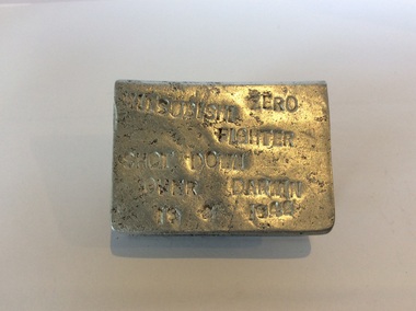
Darwin was bombed by Japanese fighter bombers from Feb 1942 until Nov 1943. On 19 February 1942 Darwin itself was bombed. Japanese fighters and bombers attacked the port and shipping in the harbour twice during the day, killing 252 Allied service personnel and civilians. On 3 March Broome, in Western Australia, was strafed. In succeeding months air attacks were made on many towns in northern Australia including Wyndham, Port Hedland and Derby in Western Australia, Darwin and Katherine in the Northern Territory, Townsville and Mossman in Queensland, and Horn Island in the Torres Strait. Despite popular fears these raids were not the precursor to an invasion but they did serve to interrupt the use of Darwin's port facilities. The raids also tied up anti aircraft defences and air force units that would have otherwise been sent to more forward areas. The Bombing of Darwin www.awm.gov.auFolded metal to cover a match box top and bottom and one side. Would leave one side of the box exposed to strike a match. Lettering on top and bottom created by letter punchFront: Zero Mitsubishi Fighter Shot down over Darwin 19/2/1942 Back: From Frank to Dad.ww2, souvenir, darwin -
 Eltham District Historical Society Inc
Journal, Peter Doughtery, ArtStreams: News in arts and cultural heritage; Vol. 2, No. 2, Apr-May 1997, 1997
Vol. 2, No. 2, Apr-May 1997 CONTENTS DRAWING ON NATURE Jenny Chong discusses the long transition from pottery to sculpture 3 THE WRITER IN THE THEATRE Alison Croggon talks about the pains and joys of writing for the theatre 6 A MUSICIAN'S MUSICIAN Daniel Chable on Steve Vai 9 JOURNEYS OF THE MIND The pathway of 14 regional artists 10 THE INVISIBLE THEATRE The contribution of the Melbourne writers' theatre 13 PHOTOGRAPHY Justin McMahon's camera turns the night sky into 'light paintings' 16 NOLAN AT MUSEUM OF MODERN ART Why the Ned Kelly series is the exhibition we had to have 18 THE VOICE IN BETWEEN Short story by Archimede Fusillo 21 THEATRE AND CD REVIEW A play that puts an Aboriginal and Torres Strait Islander point of view 26 THEATRE AND CD REVIEW 27 ALAN MARSHALL AWARDS 28 SOUL OF SOCIETY Ken Strong tackles some questions of creativity 30 "Peter Dougherty has been involved in the local art scene for many years. As publisher and editor of the arts magazine Artstreams, his comments on the various branches of the arts are widely respected. His "The Arts" column in the Diamond Valley Leader presents a brief summary for a much wider cross section of the local community. Peter also operates his own gallery and the Artstreams Cafe at the St Andrews market. Peter has a wealth of knowledge about present day and historical aspects of local art and artists." - Eltham District Historical Society Newsletter No. 161, March 2005Colour front and back cover with feature articles and literary pieces with photographs and advertisements printed in black and white. 36 pages, 30 cm. Vol. 1, no. 1 (Nov. 1996) - Vol. 10, no. 5 (summer ed. 2005/06) art streams, food for all seasons, sidney nolan, ned kelly at glenrowan, jenny chong, manningham artspace, alison croggan, steve vai, daniel chable, recherche speciality picture framing, harriet dance, eva gaitatzis, manningham artspace, rick amor, jenny chong, geoffrey gordon dance, ernest fries, isabel davies, lindsay edward, kazuko eguichi, deborah halperin, inge king, grahame king, kevin lincoln, david moore, akira takizawa, tony trembath, carolyn pickett, melbourne writers' theartre, faces coffee house, eastern metropolitan opera, justin mcmahon, albert tucker, archimede fusillo, slickers, whilefood delights, eltham school of ballet, eltham little theatre, peter chapple, alan marshall short story award, janet drake, jon weaving, barry dickens, do lunch at the library licensed cafe, ken strong, wingrove cottage community clinic, helen o'grady children's drama academy, eltham high school symphonic band, james morrison, eltham wiregrass gallery & cafe