Showing 40591 items
matching colour
-
 City of Kingston
Pamphlet - Colour, T. H. Ould Publishing Co, The Ridge Estate, Cheltenham, c. 1930
Sales plan for land in the suburb of Cheltenham, bounded by Johnston Street, Silver Street and Cavanagh Street, incorporating lots on either side of Sunray Avenue.The developing urban area of Cheltenham within the City of Kingston. This land sale pamphlet illustrates the subdivision of land within the municipality and the changing demographic of the district as new houses are constructed close to infrastructure.Colour pamphlet advertising for sale lots in The Ridge Entrance Estate, Cheltenham. Incorporates a map of the estate bordered by Johnston Street, Silver Street and Cavanagh Street, including subdivision lots on either side of Sunray Avenueland sales, estate, cheltenham -
 City of Kingston
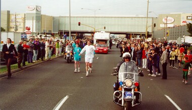
Photograph - Colour, 31 July 2000
The Olympic Games were held in Sydney in 2000. The Olympic torch progressed through Australia and prominent sporting or cultural identities were invited to carry the torch through their local areas.Colour photograph of David Douglas running in the Olympic Torch Relay as torch bearer. There is a police escort on motorbike in front and behind him, as well as a cavalcade of vans and cars behind him. Both sides of the street are lined with spectactors.Handwritten in black ink on reverse: David Douglasolympics, torch relay -
 City of Kingston
Pamphlet - Colour, Stillwell and Co, The Hill Estate Highett Great Subdivisional Auction Sale, 1917
Sales plan for land in the suburb of Highett, bounded by Point Nepean Road and incorporating Sandford Street, Turner Road, Alfred Street, Peace Street and Tennyson Street. .The developing urban area of Highett within the City of Kingston. This land sale pamphlet illustrates the subdivision of land within the municipality and the changing demographic of the district as new houses are constructed.Colour pamphlet advertising subdivisional auction sale of the Hill Estate Highett. Incorporates a map of the estate bordered by Point Nepean Road and encompassing Sandford Street, Turner Road, Alfred Street, Peace Street and Tennyson St. Handwritten in grey pencil on reverse: Hill Street / Jamieson Handwritten in blue pencil on reverse: The Hill Estate Handwritten in blue pencil on subdivision map: [tick] [on majority of properties marked on map]highett, land sales, estate -
 City of Kingston
Pamphlet - Colour, W. H. Wood Estate Agent, Realising sub-divisional auction sale Bentleigh Park Estate, Bentleigh, 1920
Sales plan for land in the suburb of Bentleigh, bounded by Centre Road, and incorporating subdivisions on either side of Elizabeth Street (Wheatley Road), Oak Street and Beech Street.The developing urban area of Bentleigh within the City of Kingston. This land sale pamphlet illustrates the subdivision of land within the municipality and the changing demographic of the district as new houses are constructed close to infrastructure.Colour pamphlet advertising a realising sub-divisional auction sale of the Bentleigh Park Estate, Bentleigh. Incorporates a map of the estate bordered by Centre Road, and including Elizabeth Street (Wheatley Road), Oak Street and Beech Street.Hand drawn in grey pencil: a small square on subdivision 33 Hand drawn in grey pencil: a small square incorporating a cross on subdivision 24 Hand written in black ink on reverse: Bentleigh Park / Estate / Ward late Andersonsland sales, estate, bentleigh -
 City of Kingston
Pamphlet - Colour, S. M. Reynolds, Estate Agent, Moorabbin Shire Hall Estate Second Section, c. 1930
Sales plan for land in the suburb of Moorabbin, bounded by South Road and Highbury Street, including Prince Street, Charming Street, Thomas Avenue and Keith Road.The developing urban area of Moorabbin within the City of Kingston. This land sale pamphlet illustrates the subdivision of land within the municipality and the changing demographic of the district as new houses are constructed close to infrastructure.Colour pamphlet advertising for private sale the Moorabbin Shire Hall Estate, Moorabbin. Incorporates a map of the estate bordered by South Road and Highbury Street, including Prince Street, Charming Street, Keith Road and Thomas Avenue.Handwritten in grey pencil on subdivision map below subdivision 63: £4 Handwritten in grey pencil on subdivision map below subdivision 66: 4 Handwritten in grey pencil on subdivision map below subdivision 80: 3. Handwritten in grey pencil on subdivision map below subdivision 81: 4 Handwritten in grey pencil on subdivision map below subdivision 83: 2 Handwritten in grey pencil on subdivision map below subdivision 96: £3 Handwritten in grey pencil on subdivision map below subdivision 97: 3 Handwritten in grey pencil on subdivision map to the left of subdivision 102: 3 Handwritten in grey pencil on subdivision map on the corner of Thomas Avenue and Highbury Street: vertical line next to a square with a cross in it.land sales, estate, moorabbin -
 City of Kingston
Pamphlet - Colour, Roy Dunn Pty. Ltd, Central Corner Estate Moorabbin and Highett, c. 1923
Sales plan for land in the suburbs of Highett and Moorabbin, bordered by Point Nepean Road and Wickham Road East incorporating William StreetThe developing urban area of Highett and Moorabbin within the City of Kingston. This land sale pamphlet illustrates the subdivision of land within the municipality and the changing demographic of the district as new houses are constructed close to infrastructure.Colour pamphlet advertising for private sale land in the Central Corner Estate in Moorabbin and Highett. Incorporates a map of the estate bordered by Point Nepean Road and Wickham Road East, with subdivisions also available on both sides of William Street. Handwritten in blue pencil on subdivision plan: a tick is drawn on subdivisions 2-18 Handwritten in blue pencil on subdivision 6: a box with an x inside Handwritten in blue pencil on subdivisions 10 and 12: S Handwritten in black ink on front page: [indecipherable] / McKittricks Handwritten in grey pencil on rear page: McKilhick / Nepean Rd Handwritten in grey pencil on rear page upside down: 160000 / 15 8300 [crossed out] land sales, estate, highett, moorabbin -
 City of Kingston
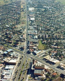
Photograph - Colour, c. 1982
This aerial photograph of South Road and Nepean Highway, Moorabbin shows the area where houses and shops on the south side of the Nepean Highway have demolished for the widening of the highway. The pressures of rapid urban development in Moorabbin and beyond, especially to the south of Moorabbin caused bottlenecks and delays, especially at the South Road and Nepean Highway intersection, hence the scheme to widen Nepean Highway.The pressures of rapid urban development in terms of people, housing construction, industrial development and commercial activity, in Moorabbin and beyond, especially to the south would put pressure on road infrastructure in the region. In the early 1980s, a major road expansion of the Nepean Highway was implemented to increase capacity on this major thoroughfare for vehicle commuters. Car use had also increased with commuters from the increasingly populous southern suburbs travelling to their place of work in the Melbourne CBD.Colour photograph of an aerial view of South Road and Nepean Highway, Moorabbin. The image shows houses on the south side of the Nepean Highway that have demolished for widening of road. It features housing and commercial buildings looking north towards Cummins Road.Handwritten blue ink: 82 - 5452 - 11 Handwritten red ink: 112% Handwritten black ink: Ch. 7nepean highway, south road, moorabbin, roads, transport, infrastructure -
 City of Kingston
Pamphlet - Colour, Farrow Falcon Press, Printers, Ozone Estate, Bluff Road, Hampton, c.1940
Sales plan for land in the suburb of Hampton (Highett), bounded by Bluff Road, Wickham Road, Peterson Street and June Street. Includes Morley Street, Follett Avenue, and Parrett StreetThe developing urban area of Highett within the City of Kingston. This land sale pamphlet illustrates the subdivision of land within the municipality and the changing demographic of the district as new houses are constructed close to infrastructure.Colour pamphlet advertising for private sale the Ozone Estate, Bluff Road Hampton. Incorporates a map of the estate bordered by Bluff Road, Wickham Road, June Street and Peterson Street including Morley Street, Follett Avenue and Parrett Street.Handwritten in grey pencil on reverse: Ozone Printed in purple ink on front top right-hand corner: Vendors are - Leslie Harcourt MacGowan, Esq / Neerim Road, Caulfield / & / Arthur Alfred Parrett, Esq / 311 Flinders Lane / Melbourneland sales, estate, hampton, highett -
 City of Kingston
Pamphlet - Colour, Farrow Falcon Press, Printers, Ozone Estate, Bluff Road, Hampton, c. 1940
Sales plan for land in the suburb of Hampton (Highett), bounded by Bluff Road, Wickham Road, Peterson Street and June Street. Includes Morley Street, Follett Avenue, and Parrett StreetThe developing urban area of Highett within the City of Kingston. This land sale pamphlet illustrates the subdivision of land within the municipality and the changing demographic of the district as new houses are constructed close to infrastructure.Colour pamphlet advertising for private sale the Ozone Estate, Bluff Road Hampton. Incorporates a map of the estate bordered by Bluff Road, Wickham Road, June Street and Peterson Street including Morley Street, Follett Avenue and Parrett Street.Handwritten in grey pencil on rear: Ozone Estateland sales, estate, highett, hampton -
 City of Kingston
Pamphlet - Colour, Brock Bros, South Brighton Township Estate, 1888
Sales plan for land in the suburb of South Brighton (Moorabbin), bounded by Point Nepean Road, South Road, Patterson Street and the Mordialloc Railway Line. Incorporates Wolsely Street and Gordon StreetThe developing urban area of Moorabbin within the City of Kingston. This land sale pamphlet illustrates the subdivision of land within the municipality and the changing demographic of the district as new houses are constructed close to infrastructure.Colour pamphlet advertising for private sale the South Brighton Township Estate, South Brighton. Incorporates a map of the estate bordered by Point Nepean Road, South Road, Patterson Street, and the Mordialloc Railway Line. Includes Wolsley Street and Gordon Street. land sales, south brighton, estate, moorabbin -
 City of Kingston
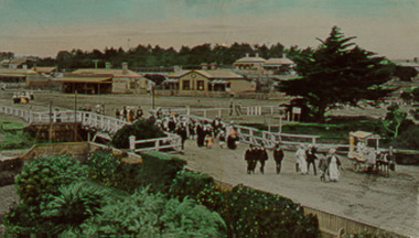
Negative - Colour
Colour image of people walking across the bridge at Mordialloc Creek toward the Bridge Hotel. In the background are houses and businesses, a large conifer stands on the other side of the creek and, in the foregrround, is some type of small cart. The original image appears to have been a postcard. -
 City of Kingston
Photograph - Colour, 2000
Narratives of Kingston was an oral history project where the personal memories of residents were collected and compiled into a reference book. The image suggests there was also an exhibition of personal photographs as the people depicted are standing in front of photo boards.Colour photograph taken at the launch of the Narratives of Kingston project. Depicted in the image (L to R) are Ron Jacobs, President Chelsea Historical Society, Sylvia Roberts, granddaughter of Roderick Mills/Saltbush Bill, Mayor Arthur Athanasopoulos, and Piri White, member of the Narratives team.oral history, kingston, mayor, historical societies -
City of Kingston
Photograph - Colour, 2000
Narratives of Kingston was an oral history project where the personal memories of residents were collected and compiled into a reference book. The image suggests there was also an exhibition of personal photographs as the people depicted are standing in front of photo boards.Colour photograph taken at the launch of the Narratives of Kingston project. Depicted in the image (L to R) are Ron Jacobs, President Chelsea Historical Society, Sylvia Roberts, granddaughter of Roderick Mills/Saltbush Bill, Mayor Arthur Athanasopoulos, and Piri White, member of the Narratives team.oral history, kingston, mayor -
 City of Kingston
Pamphlet - Colour, J. F. Brady, Matthiesson's Estate, Highett, c. 1905
Sales plan for land in the suburb of Highett, bounded by Tennyson Street, James Street and Point Nepean Road and including Maher Street, Connors Street, Enright Street, Edward Street, James Street and Matthieson Street.The developing urban area of Highett within the City of Kingston. This land sale pamphlet illustrates the subdivision of land within the municipality and the changing demographic of the district as new houses are constructed close to infrastructure.Colour pamphlet advertising for private sale subdivisions in the Matthiesson's Estate, Highett. Incorporates a map of the estate bordered by Tennyson Street, James Street and Point Nepean Road and including Maher Street, Connors Street, Enright Street, Edward Street, James Street and Matthieson Street.Handwritten in blue pencil: x marked on every subdivision on the map Handwritten in grey pencil at the end of the Price List: x not sold Handwritten in grey pencil adjacent to subdivisions 58, 167 and 166: JP. Turner Handwritten in grey pencil adjacent to subdivision 164: [indecipherable] Markings in grey pencil around the edges of the subdivision map Handwritten in grey pencil on reverse: Matthiesson / Matthiesson Estate / Matthiesson Estateland sales, estate, highett -
 City of Kingston
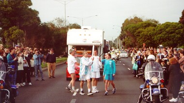
Photograph - Colour, 31 July 2000
The Olympic Games were held in Sydney in 2000. The Olympic torch progressed through Australia and prominent sporting or cultural identities were invited to carry the torch through their local areas.Colour photograph of Olympic torch relay as it made its way through Kingston. The torch is being exchanged between Russell Broughton on the left and Allan Lawson on the right. They are surrounded by relay support crew, including a motorcade travelling behind them, and the street is lined with people on both sides.Handwritten in black ink on reverse: Allan Lawson / Russell. Broughtonolympics, torch relay -
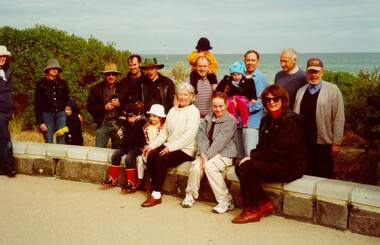 City of Kingston
Photograph - Colour, July 2000
This photograph depicts workers/volunteers who planted trees on foreshore at Bonbeach & Carrum as part of National Tree Day. Councillor Topsy Petchey, OAM, is on the right.Colour photograph of a group people sitting on a low stone wall. The group is a mixture of ages, including very young children and the ocean is visible in the background. The group is a volunteer group who planted trees on the foreshore and Bonbeach and Carrum for National Tree Day. Councillor Topsy Petchey on right. Handwritten on reverse in black ink: National Tree Day / G Pet.bonbeach, carrum, ocean, trees, environment, volunteers, councillors -
 City of Kingston
Photograph - Colour, Paul Tresize, 1998
The name Mordialloc was derived from the name Moody Yallock, which comes from the Bunurong language. The Bunurong Peoples are the Traditional Owners of this area. The name means “high water” or “high creek”. In 1839, colonial authorities declared the mouth of the creek, and an additional 830 odd acres as an Aboriginal Reserve, although this proclamation was never gazetted. The reserved land included part of the Carrum Carrum Swamp which was abundant with wild life and natural resources. Regular encroachments, including land sales which began in 1863, were made on the land until 1878 when the Reserve was declared closed, and the land was opened up to land sales. Market gardening and suburban house lots quickly began to develop, and Mordialloc became a renowned picnic and holiday site. Mordialloc Creek is a popular bay side destination for local and visitors, and is a site for boating, kayaking, fishing and swimming, along with many other activities.Colour photograph of Mordialloc Creek, looking out to the bay. Many small fishing and leisure craft are moored on either side of the banks of the creek. To the right hand side can be seen parklands, while the left hand side has a small inlet in which more small crafts are moored.mordialloc, bunurong, traditional owners, suburbs, boats, fishing, waterways -
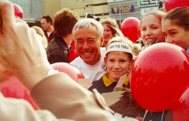 City of Kingston
Photograph - Colour, 31 July 2000
The Olympic Games were held in Sydney in 2000. The Olympic torch progressed through Australia and prominent sporting or cultural identities were invited to carry the torch through their local areas.Colour photograph depicting Craig Kimberley of Just Jeans (retail store) surrounded by people, including a boy wearing a paper bandana that says "I saw the torch". The photograph has been taken outside Westfield Shopping Centre (Southland) and the event was part of the torch relay for the 2000 Olympic Games.Handwritten in black ink on reverseL Craig Kimberley / Just Jeansolympics, torch relay -
 City of Kingston
Pamphlet - Colour, Arthur Tuckett & Son, Auctioneers and Subdivisional Specialists, Auction of Station Estate, Moorabbin, 1923
Sales plan for land in the suburb of Moorabbin, bounded by Railway Crescent, South Road, Jasper Road and Pattersons Road.The developing urban area of Moorabbin within the City of Kingston. This land sale pamphlet illustrates the subdivision of land within the municipality and the changing demographic of the district as new houses are constructed.Colour pamphlet advertising an auction of the Station Estate Moorabbin. Incorporates details of the shopping facilities, proximity to the railway line, variety of schools and churches in the area, and a sales plan for home sites and shop fronts. Incorporates a map of the estate bordered by Pattersons Road, Japer Road, South Road and Railway Crescent. Handwritten in grey pencil top right front page: Station Estate / late [indecipherable] Handwritten in red pencil on subdivision map: x [on majority of properties marked on the map] Handwritten in grey pencil on subdivision map: additional subdivisions drawn in and large lines drawn across the mapmoorabbin, land sales, estate -
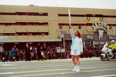 City of Kingston
Photograph - Colour, 31 July 2000
The Olympic Games were held in Sydney in 2000. The Olympic torch progressed through Australia and prominent sporting or cultural identities were invited to carry the torch through their local areas.Colour photograph of Naomi Milgrim, CEO of Sussan Fashions, outside Westfield Shopping Centre Cheltenham (Southland), participating in the Olympic Torch Relay. Behind her a crowd can be seen gathered to watch the relay. There is a motorcycle police officer in a high visibility jacket to the right. Spectators can be seen on the roof of the building.Handwritten on reverse in black ink: CEO Sussan Fashions / Naomi / Milgrimolympics, torch relay, cheltenham -
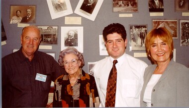 City of Kingston
Photograph - Colour, 2000
Narratives of Kingston was an oral history project where the personal memories of residents were collected and compiled into a reference book. The image suggests there was also an exhibition of personal photographs as the people depicted are standing in front of photo boards.Colour photograph taken at the launch of the Narratives of Kingston project. Depicted in the image (L to R) are Ron Jacobs, President Chelsea Historical Society, Sylvia Roberts, granddaughter of Roderick Mills/Saltbush Bill, Mayor Arthur Athanasopoulos, and Piri White, member of the Narratives team. People pictured are standing in front of a photo board.Handwritten in red ink on reverse: K000740.tif Launch of Narratives of Kingston / Ron Jacobs - Presidetn Chelsea Hist Soc / Sylvia Roberts - granddaughter of / Roderick Mills/Saltbush Bill / Mayor Arthur - Mayor of Kingston / Piri White - member of Narratives Teamoral history, kingston -
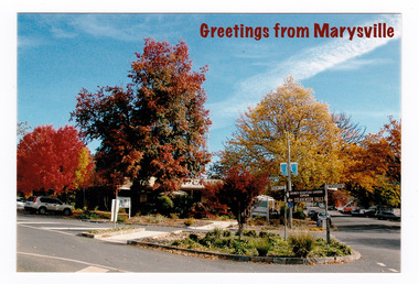 Marysville & District Historical Society
Postcard (item) - Colour postcard, Marysville Post Office, Greetings from Marysville, Post 2009
A colour photograph taken of Signpost Corner during Autumn in Marysville in Victoria.A colour photograph taken of Signpost Corner during Autumn in Marysville, Victoria. This corner was known as Signpost Corner. This postcard was produced by the Marysville Post Office as a souvenir of MarysvilleA Kaleidoscope of Colour Marysville Post Office AFFIX/ STAMP/ HERE Postcard by Sandy Berthelsenmarysville, victoria, autumn, postcard, souvenir, marysville post office -
City of Kingston
Photograph - Colour, 1993
Carrum is a suburb in the City of Kingston bordered by the Patterson River in the north and Kananook Creek in the south. To the east the suburb is adjacent to Patterson Lakes. The Carrum Station was opened in 1882, when the railway line from Mordialloc was extended to Frankston. In the early 20th century, it was a destination for holidaymakers occupying tents and cabins. The area now consists of older housing and over time there have been many new housing developments.Carrum is located in the area that was originally part of the Carrum Carrum Swamp. The district had originally been the home of the Bunerong people who fished, gathered food and found refuge in the sand dunes. The Swamp was drained in 1879 when the Patterson Cut was formed and became known as Patterson River. Apart from local farmers, fishermen and hotel-keepers, there were few permanent residents until the early 20th century when it had become popular as a beach resort. In the 1920s and 1930s the area became occupied by more permanent residents.Laminated aerial colour photograph of Carrum and Patterson Lakes in the City of Kingston. The photograph also includes Kananook Creek and the northern section of Seaford. Prominent features include Roy Dore Reserve, Carrum Primary School, Patterson River Secondary College, Keast Park Seaford, the Seaford Swamp Drain and a section of Downs Estate situated on the traditional lands of the Bunurong people.Black type on white adhesive sticker: No. 7140 Black type of white adhesive sticker: 31-1-93 Black handwritten ink (marker): * [an asterisk] Yellow circular adhesive stickerpatterson lakes, seaford, carrum carrum swamp -
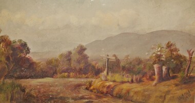 Ringwood and District Historical Society
Painting, "Wantirna" - Water colour on paper by Winifred Miles (1884-1944), Undated, later than 1910
"Alexander Colquhoun [Herald art critic 1914-1922 and feature writer for the Age 1926-1941] ... took private students in the first decade of the century, and one of these was Winifred Miles, who after her marriage in 1910 lived the remainder of her life in Ringwood. ... (She) began by doing charcoal studies of animals when she was in Balranald, but in later years moved to oils and then watercolours, travelling around Ringwood to find places to paint by means of a pony-driven governess-cart. She won prizes for paintings in the Royal Melbourne Shows." - Hugh Anderson - Ringwood, Place of Many Eagles [p.217].Painting with cardboard border in glass-fronted frame. One of two undated paintings by Winifred Miles' viewed from the same vantage point in Wantirna. (See Registration Number 4851) -
 Ringwood and District Historical Society
Painting, Margaret Robbie, "Temporary Accommodation, Heatherdale" - Water colour on paper by Margaret Robbie, circa 1950s
"Margaret Robbie was another of the local painters who came late to art or combined it with a quite different occupation. Her grandparents, John Shaw and Margaret (Byers), went to Hobart in 1855 but then crossed the Strait and settled in Kyenton where they remained until 1918. Margaret was the issue of the marriage of Mary Shaw and Robbie. She spent a considerable time overseas for the YWCA, including a period as its General Secretary in Toronto, Canada, and worked in the Middle East during World War 2. Margaret Robbie made her garage in Ringwood Street into a flat-cum-studio-cum-gallery for her painting activities when she was not caring for her sister and an elderly aunt." - Hugh Anderson - Ringwood, Place of Many Eagles [p.218].Painting with cardboard border in glass-fronted frame.Sticker on back of frame - "Ringwood Framing Gallery, 233 Whitehorse Road Ringwood, Phone 8704930" -
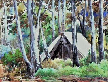
 Ringwood and District Historical Society
Painting, J. Crocker, "Natural Bush" - Water colour on paper by J. Crocker, (undated)
Painting with cardboard border in glass-fronted frame.Sticker on back of frame - "Ringwood Framing Gallery, 233 Whitehorse Road Ringwood, Phone 8704930" -
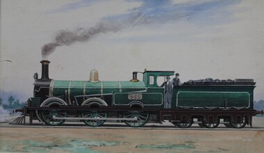 Ringwood and District Historical Society
Painting, G. Coutts, "Light Lines Goods Loco 1886" - Water colour and ink on paper by G. Coutts, (undated)
Unframed painting with cardboard border.Handwritten notations behind painting - "Light Lines Goods Loco - 1886 - "X" Class. Mr. J. Archbold on footplate of first train he drove in V.R. -
Ringwood and District Historical Society
Painting, J. Pials, Early Ringwood Cottage - Water colour on paper painting by J. Pials, (undated)
Painting with cardboard border in glass-fronted frame. -
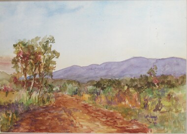 Ringwood and District Historical Society
Painting, Winifred Miles, "Mullum Road" (Ringwood) - Water colour on paper by Winifred Miles (1884-1944), Undated, later than 1910
"Alexander Colquhoun [Herald art critic 1914-1922 and feature writer for the Age 1926-1941] ... took private students in the first decade of the century, and one of these was Winifred Miles, who after her marriage in 1910 lived the remainder of her life in Ringwood. ... (She) began by doing charcoal studies of animals when she was in Balranald, but in later years moved to oils and then watercolours, travelling around Ringwood to find places to paint by means of a pony-driven governess-cart. She won prizes for paintings in the Royal Melbourne Shows." - Hugh Anderson - Ringwood, Place of Many Eagles [p.217].Painting with cardboard border in glass-fronted frame. One of two undated paintings by Winifred Miles' viewed from the same vantage point on Mullum Mullum Road in Ringwood. (See Registration Number 4848)Sticker on back of frame - "Ringwood Framing Gallery, 233 Whitehorse Road Ringwood, Phone 8704930" -
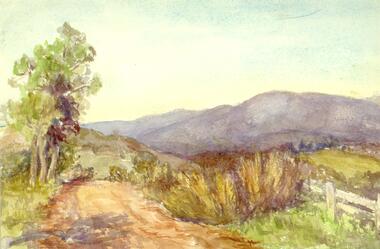 Ringwood and District Historical Society
Painting, Winifred Miles, "Mullum Road" (Ringwood) - Water colour on paper by Winifred Miles (1884-1944), Undated, later than 1910
"Alexander Colquhoun [Herald art critic 1914-1922 and feature writer for the Age 1926-1941] ... took private students in the first decade of the century, and one of these was Winifred Miles, who after her marriage in 1910 lived the remainder of her life in Ringwood. ... (She) began by doing charcoal studies of animals when she was in Balranald, but in later years moved to oils and then watercolours, travelling around Ringwood to find places to paint by means of a pony-driven governess-cart. She won prizes for paintings in the Royal Melbourne Shows." - Hugh Anderson - Ringwood, Place of Many Eagles [p.217].Painting with cardboard border in glass-fronted frame. One of two undated paintings by Winifred Miles' viewed from the same vantage point on Mullum Mullum Road in Ringwood. (See Registration Number 4847)Sticker on back of frame - "Ringwood Framing Gallery, 233 Whitehorse Road Ringwood, Phone 8704930"