Showing 908 items matching " railway construction"
-
 Orbost & District Historical Society
black and white photographs, first half 20th century
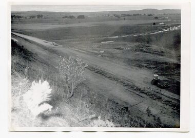
... to Bairnsdale Railway. road-construction-Newmerella Princes-freeway ...3255.1 is a photograph of the Princes Freeway construction of the roadway embankment at the foot of Newmerella Hill. 3255.2 is of the construction of the roadway, the Princes Freeway looking down from Newmerella toward Orbost. 3255.3 shows the Princes Freeway from Grandview , Newmerella, and shows the southern end of Ashby's Gulch with its bridge. 3255.4 is of the Princes Freeway showing the bridge across Ashby's Gulch and a train on the railway viaduct. Ashby's Gulch is named for the Ashby family. The Ashby family was one of the early settlers in Orbost at Newmerella. Roy Ashby, son of James Rowland Ashby and Edith Annie Hall, was born on 21 Nov 1892 in Orbost. Victoria. Australia and died in 1942 in Orbost. Victoria. Australia at age 50. Roy married Elsie May Stephens, daughter of James Stephens and Sarah Taylor, in 1920 in Victoria.Australia. Elsie was born on 15 Sep 1898 in Beaconsfield Tasmania.Australia and died in 1974 in Orbost Australia at age 76. Their children were: Roy Ashby, William Henry Ashby, Cordelia Valma Ashby and Edith Ashby. This photograph is associated with the construction of the main roads into Orbost. It is also connected to the Orbost to Bairnsdale Railway.Four black / white photographs of road construction and rail bridges.road-construction-newmerella princes-freeway-newmerella ashby's-gulch-newmerella orbost-railway -
 Orbost & District Historical Society
calendar, Old Views of Gippsland, 2000
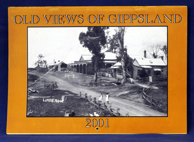
The East Gippsland Historical Society has produced an annual calendar 'Old Views of Gippsland' since 2003. This item is a useful reference for the history of Gippsland.A 2001 stapled calendar, titled "Old Views of Gippsland".On the front is a black/white photograph of the main street of Lindenow. It contains early photographs of East Gippsland, one for each month. December has a photograph of Nicholson street in Orbost and October has a photograph of the construction of the East Gippsland railway at the Newmerella cutting. calendar photographs-gippsland -
 Ringwood and District Historical Society
Photograph, Construction of Heathmont railway station by the Wieland family, 1926. Four photographs
... Construction of Heathmont railway station by the Wieland... (1957-004) 11.2 c 6.7 cms) Construction of Heathmont railway ...3 large black and white photographs (1957-001 to -003) 25x15cms mounted on white board, plus one small B&W photograph (1957-004) 11.2 c 6.7 cms)On 1957-001: Typed below photograph, "Building Heathmont railway station platform by Wieland brother 1926. Note use of plough." On 1957-002: Typed below photograph, "Building Heathmont railway station platform by Wieland brother 1926. Heathmont Rd in Background." On 1957-003: Typed below photograph, "Building Heathmont railway station platform by Wieland brother 1926. Canterbury Rd in Centre Background, Bridge to left." On Reverse of 1957-004, handwritten: "All the men in Heathmont made the Heathmont Station. The one with X over him is dad. This was taken when they were making it before it was burned down, Ruby, xxxxxxxXXX" -
 Orbost & District Historical Society
document in folder, Bairnsdale to Orbost Railway Paper Delivered by Maurice Kernot 1917, March 2016
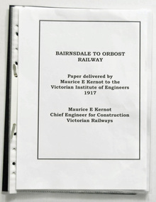
This item was made for the Orbost Railway 100 Years Exhibition held at Orbost in March, 2016. It is a copy of an original paper delivered by Maurice Kernot to the Victorian Institute of Engineers in 1917. Maurice Edwin Kernot was the vice president and managed the construction of the Bairnsdale-Orbost Railway in 1912. The Bairnsdale-Orbost railway was opened in 1916 to serve the agricultural and timber industry. Because of the decline in traffic and heavy operating costs, the line was finally closed in August, 1987.This item is associated with the history of the Orbost-Bairnsdale railway line and therefore reflects the role that the rail line played in the social and economic history of Orbost.Seventeen pages of photocopied document in a black plastic folder. The pages are in separate sleeves. On the back is a price sticker $1 flat file Marbig Single - Red Orbost Authorid News.orbost-bairnsdale-railway east-gippsland-railway kernot-maurice railway -
 Flagstaff Hill Maritime Museum and Village
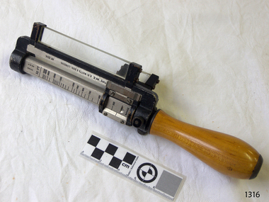
Rangefinder, E R Watts & Sons, 1930-1945
E. R. Watts and Son, makers of theodolites and other surveying instruments, of 123 Camberwell Road, London. The company was established in 1856 by Edwin Watts at twenty-three he had saved £100 from his earnings to start the business with his staff consisting of one boy and later Alexander Clarkson as an apprentice with the workshop a small room over a Bemondsey stable. Watts' first order was from Negretti and Zambra for a mining dial Alexander Clarkson In the early days the firm worked mainly on marine compasses. Edwin Watts would go down to the Docks to adjust the compasses once they had been installed on the ships. In May 1873 the business moved to larger premises a house with a garden. The workshop was also the home of Mr and Mrs Watts and their five sons and three daughters. By now there were fifteen to twenty men employed by the firm. The company were commissioned to supply the Theodolites and Levels for the construction to the Canadian Pacific Railway in 1881. Towards the end of the century, the firm began to make heliographs continuing to produce them for the government until just before the Second World War when by agreement assigned their manufacture to another firm. 1904 The first dividing engine was completed by George William Watts. It was so remarkable an instrument at the time and for years afterwards, In 1907 Arthur Ames went to Canada and started an organisation in Winnipeg in 1909 this became a separate company called E. R. Watts and Son Ltd. of Ottawa. This firm developed considerably and was eventually with the co-operation of three other instrument companies (Cambridge Instrument Co, Ross, and Negretti and Zambra), were reconstituted as ”Instruments Ltd” of Ottawa and Toronto. During the next ten years, the firm expanded greatly to include glass grinding, leather work, dividing and engraving, testing, adjusting and packing. This expansion was continued during the First World War when workshops were completed and the machinery installed and running within eleven weeks from the start of construction. During the war, a Sergeant Coles, among the rats, lice and mud of the trenches, fitted various bits of scrap into his cocoa tin and made the first Flash Spotter for plotting the positions of enemy guns. Coles was rushed home to the firm's factory where he and George William Watts designed a spotter not made out of a cocoa tin and as a result, the Watts Vertical Force Variometer was developed during WWI. Other Watts instruments made in the First World War included the Light Mountain Theodolites which were taken on Mt Everest expeditions. In 1919 ER Watts and Sons was incorporated as a limited company and in 1939 G. A. Whipple joined the Board of Directors. Shortly afterwards, Frank Charles Watts died having been Chairman of the firm for over 37 years and seen it through the First World War with all its expansions and difficulties. He was succeeded by his brother George William Watts with the vacant post of Managing Director being filled by G. A. Whipple. During the Second World War, the company expanded further and the number of employees rose to well over 1,300. In 1946 Watts acquired 78% of Adam Hilger and the microscope maker James Swift and Son Who were Manufacturers of Theodolites, Levels, Alidades, Meteorological Instruments, Variometers, and many other types of scientific instruments Then in 1948 the company amalgamated with Adam Hilger as Hilger and Watts which was then incorporated as a public company.Naval Rangefinder with a vertical wooden handle, and an arrangement of optical lenses. Three reversible brass inserts calibrated on both sides in yards, correspond to various base heights, (20 and 25 feet, 30 and 35 feet and 40 and 50 feet). They are fitted along the axis of the instrument. When the scale for the appropriate base height is selected and inserted, the carriage can be slid for coincidence and the distance read at the index mark on the sliding carriage.inscribed "Rangefinder Cotton Type Mk II" Calibrated scale up to 5000 yds (50 ft), 5000 yds (35 ft), 4000 yds (25 ft) made by E. R. Watts & Son.flagstaff hill, warrnambool, shipwrecked coast, flagstaff hill maritime museum, maritime museum, shipwreck coast, flagstaff hill maritime village, great ocean road, rangefinder, cotton type, e r watts & sons, naval range finder, marine equipment -
 Eltham District Historical Society Inc
Photograph, Demolishing the Bini Shell at Diamond Creek, 1991, 1991
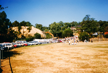
In 1978 Diamond Valley Shire recognised the need for a new public hall in Diamond Creek. Council considered the Bini shell form of construction which was in operation overseas and in use in New South Wales as libraries, gymnasiums, sports centres and multi-purpose centres. The Council gave the go-ahead. A site was chosen opposite the Hotel and close to the railway line. One day in - the following year, in 1979, activity stood still in Diamond Creek as school children and other excited spectators watched the one-hour inflation of the Bini Shell. This unusual method of construction was invented by Italian industrial designer and architect Dante Bini. The construction pneumatically raises a level of reinforced concrete from ground level which has not been set, using an internal balloon. The inner membrane inflates and compresses the mesh and concrete against the outer membrane. A net of flexible steel rods was laid on the building’s circular base, on the top of a fabric bladder. 300 tonnes of reinforced concrete were poured onto the mesh and a sealed cover laid over the concrete making a sandwich of cover, bladder and mesh. Compressed air was pumped into the bladder and the sandwich slowly began to rise and become a massive self-supporting dome. After inflation and removal of the outer membrane workmen filled in any holes. It was some days before pneumatic drills pecked out the first opening. The ceiling of the concrete dome was lined with fluffy insulating material. The dome was 36 metres in diameter at the base and 12 metres high in the centre with a usable floor space of 670 square metres. An opening night dinner was held to celebrate the new facility on March 12, 1980. Shire President Ron Pata made a speech and unveiled a plaque. It was the first public building in Victoria to be erected using the Bini Shell design method of construction The facility could cater for up to 400 people and in 1980 a fee for use was $100 for up to 200 people, $150 for up to 300 people and $200 for up to 400 people. For the next ten years or so, locals attended the hall for marital arts classes, basketball and netball games and school discoes and various other activities. After pieces of concrete fell off a Bini shell interstate due to a construction fault, the Council closed the centre. Demotion took place during the Diamond Creek Town Fair in 1991, as part of the annual Town Fair’s program. Research by L.P. Jan 2022This was the first public building in Victoria to be erected using the Bini Shell design method of construction.Colour photograph1991, diamond creek, bini shell, demolition, oval -
 Eltham District Historical Society Inc
Photograph, Fred Mitchell, Bini Shell at Diamond Creek, 1983, 1983
In 1978 Diamond Valley Shire recognised the need for a new public hall in Diamond Creek. Council considered the Bini shell form of construction which was in operation overseas and in use in New South Wales as libraries, gymnasiums, sports centres and multi-purpose centres. The Council gave the go-ahead. A site was chosen opposite the Hotel and close to the railway line. One day in - the following year, in 1979, activity stood still in Diamond Creek as school children and other excited spectators watched the one-hour inflation of the Bini Shell. This unusual method of construction was invented by Italian industrial designer and architect Dante Bini. The construction pneumatically raises a level of reinforced concrete from ground level which has not been set, using an internal balloon. The inner membrane inflates and compresses the mesh and concrete against the outer membrane. A net of flexible steel rods was laid on the building’s circular base, on the top of a fabric bladder. 300 tonnes of reinforced concrete were poured onto the mesh and a sealed cover laid over the concrete making a sandwich of cover, bladder and mesh. Compressed air was pumped into the bladder and the sandwich slowly began to rise and become a massive self-supporting dome. After inflation and removal of the outer membrane workmen filled in any holes. It was some days before pneumatic drills pecked out the first opening. The ceiling of the concrete dome was lined with fluffy insulating material. The dome was 36 metres in diameter at the base and 12 metres high in the centre with a usable floor space of 670 square metres. An opening night dinner was held to celebrate the new facility on March 12, 1980. Shire President Ron Pata made a speech and unveiled a plaque. It was the first public building in Victoria to be erected using the Bini Shell design method of construction The facility could cater for up to 400 people and in 1980 a fee for use was $100 for up to 200 people, $150 for up to 300 people and $200 for up to 400 people. For the next ten years or so, locals attended the hall for marital arts classes, basketball and netball games and school discoes and various other activities. After pieces of concrete fell off a Bini shell interstate due to a construction fault, the Council closed the centre. Demotion took place during the Diamond Creek Town Fair in 1991, as part of the annual Town Fair’s program. Research by LP January 2022This was the first public building in Victoria to be erected using the Bini Shell design method of construction.Digital copy of colour photographfred mitchell collection, 1983, bini shell, diamond creek -
 Glen Eira Historical Society
Album - Album page, Hotham Street, Circa 1972
This photograph is part of the Caulfield Historical Album 1972. This album was created in approximately 1972 as part of a project by the Caulfield Historical Society to assist in identifying buildings worthy of preservation. The album is related to a Survey the Caulfield Historical Society developed in collaboration with the National Trust of Australia (Victoria) and Caulfield City Council to identify historic buildings within the City of Caulfield that warranted the protection of a National Trust Classification. Principal photographer thought to be Trevor Hart, member of Caulfield Historical Society. Most photographs were taken between 1966-1972 with a small number of photographs being older and from unknown sources. All photographs are black and white except where stated, with 386 photographs over 198 pages.Victorian Heritage Database - Hotham Street Road Overbridge HO116 Heritage Overlay - City of Glen Eira https://vhd.heritagecouncil.vic.gov.au/places/43557 (as of 04/07/2021) The Hotham Street road overbridge is located on the Sandringham railway line between Ripponlea and Elsternwick railway stations. It is presumed to have been built by contractors Sharp and Campbell who signed a contract on 25th . November, 1881 to construct a second line of railway between Windsor and Elsternwick. This contract was completed during 1882 and the bridge may have been designed in the year when Robert Watson took over from William Elsdon as engineer in chief for the Victorian railways. It is historically, aesthetically and technically significant. It is historically significant (Criterion A) to the extent that it demonstrates the standards of construction adopted by the Victorian Railways Department when it rebuilt the lines acquired from the private railway companies, (compare the Geelong and Melbourne Railway Co's line from Newport to Geelong, acquired in 1860). It is aesthetically significant (Criterion E) as an intact nineteenth century structure of its type, many similar girder bridges having been renewed with concrete girders in recent years. The bluestone abutments demonstrate high standards of stone masonry and are representative of Departmental work of the period. This bridge forms one of a group of historic structures on the railway to Brighton Beach and therefore contributes to the line's cultural importance as a whole. The survival of the riveted iron girders with their bellied angle iron struts is important since these elements are representative of the civil engineering practices of the Victorian Railways at the time and constitute the technical significance (Criterion F) of the structure.Page 96 of Photograph Album with three photographs (one portrait and two landscape) from Hotham Street - two external views of one house and a railway bridge.Handwritten: Hotham Street [top right] / 112 HOTHAM ST [under top left photo] / BRIDGE OVER SANDRINGHAM RAILWAY [under top right photo] / 112 HOTHAM ST CNR MELBY AVE [under bottom left photo] / 96 [bottom right]trevor hart, elsternwick, hotham street, caulfield, houses, brick, bay windows, verandahs, railway bridges, tunnels, gardens, bluestone, civil engineering, victorian railways, sharp and campbell, contractors -
 Glen Eira Historical Society
Album - Album page, Normanby Road, Circa 1972
This photograph is part of the Caulfield Historical Album 1972. This album was created in approximately 1972 as part of a project by the Caulfield Historical Society to assist in identifying buildings worthy of preservation. The album is related to a Survey the Caulfield Historical Society developed in collaboration with the National Trust of Australia (Victoria) and Caulfield City Council to identify historic buildings within the City of Caulfield that warranted the protection of a National Trust Classification. Principal photographer thought to be Trevor Hart, member of Caulfield Historical Society. Most photographs were taken between 1966-1972 with a small number of photographs being older and from unknown sources. All photographs are black and white except where stated, with 386 photographs over 198 pages. From: Glen Eira Heritage Management Plan (1996) - Vol 2 by Andrew Ward and Associates The widening of Dandenong Road during the late 1980's has resulted in the destruction of the houses in the path of the roadworks and the construction of a high fence serving as a visual barrier between that thoroughfare and the remaining houses. Where comparatively large villas once stood on spacious allotments, only "Wisteria" survives at No. 135 Normanby Road. Adopting forms and timber enrichment characteristic of the American Queen Anne style, it has this in common with the largely reconstructed timber villa at no. 11 Normanby Avenue and to a lesser extent, 746 Inkerman Road. Normanby Road retains its comparatively opulent Edwardian character in a mature landscaped setting with spacious gardens and mature planes parallel with the railway reserve which, on account of the low lying ground in its vicinity has a high embankment commencing on the alignment of Malvern Grove and continuing to Caulfield Station. The earliest villas are Edwardian. Page 148 of Photograph Album with one landscape photograph of a house on Normanby Road (not Street).Handwritten: Normanby St [top right] / 148 [bottom right]trevor hart, verandah, porch, bull nosed verandah, tower house, tower, stone fence, normanby road, wisteria, american queen anne style, queen anne style, 1890's, mayfield grove, normanby street, timber houses, caulfield north, house names, edwardian, edwardian style, gardens -
 Glen Eira Historical Society
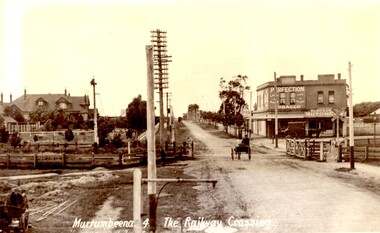
Article - MURRUMBEENA ROAD RAILWAY CROSSING
This file contains eleven items: 10 original photographs and 1 newspaper cutting. 1/A black and white photograph titled in the format of the shot ‘Murrumbeena. 4. The Railway Crossing’, date unknown, estimated to be 1905. Donated by the Hermes Studio on 19/11/1980. 2/A black and white photograph with a white border of the signal box at Murrumbeena Station by R.P Dunbar dated 16/03/1979 with a handwritten description on the back. 3/A black and white photograph with a white border of the interior of the Murrumbeena Train Station Signal box with a man identified as Michael sitting, taken by R.P Dunbar dated 17/03/1979 with a handwritten description on the back. 4/A black and white photograph with a white border of the removal the boom gates at Murrumbeena Train Station railway crossing. Taken by R.P Dunbar printed 28/04/1979, which includes a handwritten description on the back. 5/A black and white photograph with a white border of the removal of the boom gates taken by R.P Dunbar dated 29/04/1979, with a handwritten description on the back. 6/A black and white photograph with a white border of Murrumbeena Road Crossing during the removal of the boom gates taken by R.P Dunbar printed 29/04/1979. This includes a hand written description on the back. 7/A black and white photograph with a white border of the Murrumbeena Road Railway Crossing during the removal of the boom games dated 29/04/1979, taken by R.P Dunbar, with a hand written description of the photograph on the back. 8/A black and white photograph with a white border of Murrumbeena Road Crossing during the removal of the boom gates dated 29/04/1979 taken by R.P Dunbar with a handwritten description on the back. 9/A black and white photograph with a white border of Murrumbeena Road Railway Crossing with a new boom barrier replacing the boom gates, taken by R.P Dunbar dated 29/04/1979. Including a handwritten description on the back. 10/A black and white photograph with a white border of Murrumbeena Railway Station, Murrumbeena Road with the replacement boom barriers in place, taken by R.P Dunbar dated 29/04/1979. Including a hand written description on the back. 11/A newspaper article titled ‘Boom gates to create road Chaos’ written by Adam Carey from ‘The Age’ dated 29/11/2011. This includes a coloured photograph of the Murrumbeena Road Level Crossing taken by Michael Clayton Jones, and a map of the train line and level crossing between Carnegie Station and Hughesdale Station. The article makes educated predictions based on VicRoads Studies of future implications on road traffic unless more level crossings are removed. In particular the Dandenong corridor and Murrumbeena Road crossings are identified as high priority on the list of potential crossings which may have to be removed. Additionally the article discusses options the government has in addressing the dilemma, and the opinion of a Carnegie pharmacist Gerald Galatis whose business is near the level crossing on Koornang Road.transport, railway crossing, koornang road, railways, level crossing, gates, trains, road crossing, transport establishments, signal boxes, murrumbeena railway station, dunbar r.p., murrumbeena road, carnegie station, railway lines, railway buildings, road traffic, galatis gerald, construction sites, poath road, neerim road, hermes studio -
 Glen Eira Historical Society
Article - ORMOND RAILWAY STATION
... and employees Local government Engineering Railways construction Glen ...This file contains two items: 1/ Six letters of correspondence to and from Victorian Railways regarding the decision to change the name of North Road Railway Station to South Caulfield and ultimately Ormond Station. The letters date from March 1891 til August 1897. 2/ An article from the Glen Eira/Port Phillip Leader dated 12/04/2013 regarding planning and construction works being undertaken to grade-separate the North Road level crossing.north road, caulfield south, south caulfield, north road railway station, ormond, oakley e., warrein, pritchard t. h., caulfield, caulfield shire council, glen huntly station, glenhuntly station, hyams jamie, railway stations, railways, mayors, stations, public transport, railway crossings, correspondence, local officials and employees, local government, engineering, railways construction, glen eira/port phillip leader -
Glen Eira Historical Society
Article - OUTER CIRCLE RAILWAY
This file contains five items: 1/Two copies of a document titled THE OUTER CIRCLE RAILWAY by the Royal Historical Society of Victoria and the Australian Railway Historical Society, Vic div. It details the history of the construction of the Outer Circle Railway and discussed expenses and other factors affecting the construction of the line. Notes compiled by R.K Whitehead, Research and Archives Officer Australian Railway Historical Society Victoria Division. The document includes three maps of the outer circle railway line. 2/Four newspaper articles detailing the history of the Outer Circle Railway Line. They include ten black and white images of various aspects of the railway and three line maps. The first article is titled ‘Rail Link with the Past’. In the COLLINGWOOD COURIER dated 07/10/1970, author unknown. The second article titled ‘Ghost trains of the Outer’ by Kenneth Joachim in the HERALD dated 18/04/1975. The third article is titled ‘Tracks in Time’ by Norman Thompson from NEWS, dated 13/02/1973. The fourth article is titled ‘Our Ghost Railway’ by John Townsley from the HERALD, dated 06/11/1974. 3/A letter from Victorian Railways Chief Estate Officer N.A Wigmore to the Honorary Secretary of the Caulfield Historical Society, dated 19/11/1975 regarding the leasing of land along the Outer Circle Railway Reserve from Dandenong Road to the Hughesdale Station. 4/Two copies of an article titled ‘Outer Circle Railway’ in the CAULFIELD HISTORICAL SOCIETY NEWSLETTER undated detailing the history of the outer circle line. The article includes a map of the section of the line in Caulfield. 5/A Photocopy of two images of train line locations on the Outer Circle Line. One on Warrigal Road, looking south from Ashburton dated 1936. The second is of the Black Bridge over Gardiners Creek dated 1935.outer circle railway, normanby road, caulfield station, outer circle line, rosstown junction railway, monash john, caulfield historical society, poath road, deepdene dasher, ashby dasher, dandenong road, gippsy goods, mallee root mercury, outer circle railway reserve, railway lines, railway stations, steam trains -
 Glen Eira Historical Society
Letter - Rosstown Railway
This file contains two items: 1/A group of eight letters, predominantly between Hon. Secretary of Caulfield Historical Society R. Ballantyne and members of the Caulfield City Council written between 1981 and 1983, regarding the installation of a plaque in commemoration of the centenary of the Rosstown Railway. The first two letters are handwritten from R. Ballantyne to G. Calder and Carol Camy, dated 01/06/1981 and 22/02/1982. The letter to G. Calder supports a suggestion in the May edition of the CAULFIELD CONTACT for the installation of a plaque in celebration of the centenary of the Rosstown Railway, suggesting a potential site for another plaque on Curraweena Road. The letter to Carol Harry discusses the costing of the plague and a possible contribution towards this cost from the Caulfield Historical Society. The letter appears to be incomplete, having no sign off from the author. Attached to the letter is what appears to be a suggestion for the inscription of the plaque. The letters addressed to R. Ballantyne are typed and dated 12/06/1981, 24/06/1981, 14/07/19891, 17/12/1981 and 08/09/1983, from A. Craig and D.B. Hogan on behalf of City Manager G.K. Calder and City Liason Officer Carol Harry. All letters concern the commemorative plaque, with these from Carol Harry including handwritten notes which appear to be in R. Ballantyne’s handwriting. The final letter is from Mayoral Secretary Norma Polglase to Miss B. Snowball, dated 23/08/1983, inviting her to attend the unveiling of the plaque. Also included in the item are Council Committee Meeting minutes, dated 16/05/1981, broaching the subject of installing the plaque in Koornang Road. 2/Four colour photographs and two black and white copies of one of the photographs, all dated 18/09/1983 and showing the opening of the commemorative plaque in Marrara Gardens. Two photographs picture Mayor Brian Rudski and City Manager Graham Calder with a crowd of unidentified people present. One photograph and both copies are of the inscription on the plaque, with the wording identical to that of the handwritten note by R. Ballantyne, in item one.caulfield, caulfield south, calder g.k., calder g., hawthorn road, glen eira road, ballantyne r., office workers, caulfield contact, norman peter, groups, glen huntly, koornang road, mills, sugar mills, caulfield historical society, caulfield city council, caulfield town hall, official buildings, glen huntly neville street fourteen, parliamentary representatives, rosstown, rosstown railway, rosstown railway centenary, festivals and celebrations, centenaries, historical markers, plaques, monuments and memorials, ross murray, railways, land transport, curraweena road, parts of buildings or structures, bluestone structures, construction materials, caulfield community liaison officer, harry carol, currency, finances, onley peter, elsternwick, oakleigh, council meetings, caulfield council chambers, caulfield municipal chambers, caulfield municipal offices, craig a., caulfield city manager, city of caulfield, caulfield physical environment committee, public meetings, meetings, ross james, hogan o.b., arrow engraving, campbell f., snowball miss., elsternwick gladstone parade nineteen, walters w.r., marara road gardens, marara road, marara gardens, narrawong road, ceremonies, caulfield mayors, polglase norma, mayoral secretaries, railways routes, documents, correspondence, rudski brian, calder graham, events and activities, official buildings, insignia, local government, local officials and employees, parks and reserves, buildings structures and establishments, official events, festivals and celebrations, occupations, political processes, local history, history, financial economics, local government finance -
Glen Eira Historical Society
Letter - Heritage Watch Caulfield
This file contains 5 items: 1/Documents related to the establishment of Heritage Watch in Caulfield. This includes a typed letter to Mrs. And Mr. Campbell from Graham Walsh inviting them to attend a meeting concerning the potential establishment of Heritage Watch – dated 08/11/1989. A nomination form to elect a committee –dated 27/06/1991, and documents outlining goals, maps of proposed area designated by the council, and black-and-white photographs of Miners Cottage Elsternwick and a mansion in Ripponlea, Elsternwick. 2/Minutes of Caulfield Heritage Watch Committee meetings on 04/12/1999, 22./01/1990, 08/10/1990 and 26/11/1990. It includes aims, general business, publicity and discussion on ‘Rosecraddock’. 3/Caulfield Heritage Watch Newsletter issue number three dated June 1991. It includes a paragraph on Rosecraddock, The Grand Union Tram Junction, Caulfield Heritage Study and an invitation to the annual general meeting on 27/06/1991. 4/Financial statement for Caulfield Heritage Watch for November 1989 to May 1991. 5/A handwritten submission to save Rosecraddock from demolition, date and author unknown.caulfield train station, margaret street 28, walsh graham a., caulfield manor grove 1, shellard mr., labassa, derby road, inkerman road, kerr paul, glen huntly road, victorian houses, gladstone parade, hawthorn road, o’neill college, miners cottage regent street elsternwick, buildings, heritage, preservation, urban conservation policy, caulfield city council, campbell mr. + mrs., caulfield heritage watch committee, snowball b., kay w., spencer d., dustan don, dustan david, campbell f., hill tess, jordan p., ritchie jack, architecture, development, cultural structures and establishments, residential development, murray, wells, hopkins sherry, caulfield town hall, rodder a., caulfield contact, spiker mr., elsternwick railway, elsternwick club, committees and inquiries, meetings, rosecraddock, construction sites, property, hill l., mayoress’ room caulfield, city hall, morris e., feehan j., molony v., moore mrs., elsternwick sandham street 19, elsternwick bowling club, ward andrew, shellard mr., construction and demolition, balaclava road, tramways, tram junction, kerr paul, gardens, save rosecraddock neighbourhood group -
Glen Eira Historical Society
Document - National Trust Register
This file contains two items relating to historic buildings in Glen Eira listed on the National Trust Registry: 1/A fax, sent to Gladys Vallati on 02/03/1995 from the National Trust of Australia listing buildings on the Trust’s registry in the Glen Eira area, as well as their addresses and status on the register (5 pages). (Additional photocopy taken for preservation purposes). 2/A typed list of buildings in the Glen Eira area (mainly Caulfield) which are on the National Trust list, including address, approximate date of construction and status on the register. Date of production of the list is unknown. (6 pages).neerim road, poplar grove, avoca grove, balaclava road, orrong road, bambra road, glen eira road, hood crescent, hawthorn road, glenferri street, glenhuntly road, glen huntly road, kambrook road, kooyong road, lirrewa grove, manor grove, north road, pearson avenue, seymour road, alma road, craddock avenue, dandenong road, lyndoch avenue, orrong crescent, hotham street, nagle avenue, inkerman street, iknerman road, sandham street, selwyn street, st. georges road, willow street, grange road, station place, railway parade, alexandra street, wood crescent, elizabeth street, halstead street, mavho street, tucker road, mckinnon road, nepean highway, wheatly road, uniting church carnegie, athole, st stephen's uniting church caulfield, st aloysius' catholic church, halstead, st mary's anglican church caulfield, caulfield town hall, anseln, the glen, woolamai, caulfield house, caulfield hospital, lirrewa, labassa, fairfield hall, bellecourt, bagatelle, myoora, rosecraddock, adam and eve - karl duldig, the family - karl duldig, caulfield primary school, septimus miller memorial chapel, brighton cemetery, hopetoun gardens, state savings bank elsternwick, anderson organ, hopetoun private hospital (melrose), rippon lea, ripponlea, burreel, o'neill college, lisbon house, elsternwick club, merkin-schutze organ, presentation convent, duldig mural - kadimah cultural centre, glenmoore, craigellachie, st james the great, glenfern, grimwade house, dacre, trinity congregational uniting church glenhuntly, alnwick, holmwood, new alexandra, joscelyne organ, smith organ, fincham organ, st george's bentleigh, mckinnon progress hall, wurlitzer organ, moorabbin town hall, christ anglican church, st mary's jubilee school, st stephen's presbyterian church, elsternwick congregational church, st mary's church of england, former metropolitan fire brigade station no. 31, st mary's jubilee church, belle court, trinity congregational church, heatherbrae, carnegie, caulfield, caulfield north, caulfield south, elsternwick, glen huntly, glenhuntly, murrumbeena, st kilda east, bentleigh, mckinnon, moorabbin, ormond, national trust of australia, national trust register, houses, churches, schools, organs, vallati gladys, mansions -
Glen Eira Historical Society
Document - GARDENVALE
This file contains two items about Gardenvale, which was previously all part of Caulfield: 1/Photocopied eight page document by M. Stewart, 1961, entitled ‘The Gardenvale Story’. It describes Gardenvale Railway and surrounding roads and land. Lempriere’s Paddock, rail tracks on the main roads for the use of market gardeners’ wagons. Sale of land for O’Neill College Estate and construction of a subway through the railway embankment to Gardenvale Shopping centre, including efforts by local people and the council for work to be completed and costs. Footnote is circa 1977. 2/Map of Glen Eira printed from Council website 20/06/2014 showing Glen Eira’s share of Gardenvale.gardenvale, bent thomas, brighton, caulfield, elsternwick, railway stations, lempriere family, ‘bentville’, lempriere’s paddock, market gardens, nepean highway, nepean road, north road, kooyong road, polo, sheridan family, bluestone houses, bethlehem hospital, land subdivision, begonia street, gardenia road, gardenia street, magnolia street, lantana street, martin street, shops, ‘ben burb’, house names, padua hospital, brighton, o’neill miss, o’neill college, o’neill richard, o’neill estate, elster avenue, o’neill college estate, railway crescent, denver crescent, brentani avenue, college street, rosstown railway, brighton cemetery, ross mr, hawthorn road, ormond, gardenvale progress association, elster creek, parliamentary representatives, landscapes, gardenvale road, railway lines, subways, traders association, drainage, floods -
Glen Eira Historical Society
Book - Chisholm Institute of Technology
Chisholm Institute of Technology’s Faculty of Technology Magazine, Feedback, No.3 1989. 1988 Prospectus of Chisholm Institute of Technology Official Invitation to opening of Continuity and Change, dated November 1985. Chisholm Institute of Technology Planning Brief (draft copy) dated 1985. Includes architectural drafts of campus. Fourteen pages including Building Plans. Official invitation to staff and students’ exhibition at Chisholm Institute of Technology 1983. Chisholm Institute of Technology Conferring of Awards booklet dated May 20, 1983. Includes list of graduates, staff and council. With handwritten notes on rear end pages. Undated brochure of advertising courses offered at Chisholm Institute of Technology. Loose card inside with description At Chisholm You’ll Get More Than Just A Piece Of Paper. Includes campus plans. Chisholm Institute of Technology Open Day brochure dated 1982. Includes map at back.vaughan geoffrey n. dr., jakovidis greg, mcleod ian, mckenry keith, chisholm caroline, jones b.o. hon., coogan c. k. dr., green k.d., aboriginal medicine, solar, engineering, applied physics, prospectus, chisholm history, school of art and design, david syme business school, school of education, school of nursing, school of social and behavioural studies, faculty of technology, centre for applied mathematical modelling, centre for business technology, centre for industrial tribology, centre for development of entrepreneurs, chisholm timber engineering technology centre, international business centre, polymer research centre, building plans, building construction, invitations, caulfield plaza, princes avenue, railway avenue, queens avenue, caulfield station, derby road, caulfield east, dandenong road, caulfield, chisholm institute of technology, caulfield campus, frankston campus, education, tertiary education -
 Federation University Historical Collection
Photograph, Noel L. Harvey, Yendon Railway Station, 1968, 03/12/1968
Buninyong had no railway station so residents would travel to Yendon to catch the train. The Yendon Railway Station building was demolished soon after this photograph was taken. The bluestone was purchased by John Vernon, and was used to construct retaining walls in a garden enclosure between the first two buildings at the new Ballarat Institute of Advanced Education campus at Mt Helen. This is now known as the courtyard between building 'F' and building 'G' at the University of Ballarat mt Helen Campus. The following article was published in the Ballarat Courier on 06 December 1968. 'Yendon Station to be demolished - The old bluestone railway station at Yendon is to be demolished. C.A.D. Fisken told Buninyong Shire Council of the proposal at its meeting yesterday. Fortunately, he said, the beautiful stonework would not be lost. It would be used and incorporated in the new School of Mines building at Mt Helen. the retention of the century-old building was the subject of representations by Council to the Railways following the closure of the station for goods traffic 'some time ago'. The building had also been noted by the National Trust as one of special interest. The Railways Department advised the meeting that an inspection had been made at the Yendon level crossing, but no recommendation could be made at present for installation of flashing light signals.'Bluestone building with dressed bluestone door and window jambs and chimney. The roof is corrugated iron. The platform edge is also of bluestone construction. The building is the former Yendon Railway Station (now demolished) on the Ballarat -Geelong main line (the original Melbourne to Ballarat mainline). When the line was opened, this station may have been originally called Buninyong as it was built a number of years before the Ballarat to Buninyong branch line was built. This this has subsequently caused some confusion. The station was later renamed Yendon. Verso in blue ballpoint pen 'No 47 Yendon Railway Stn' Stamped in purple ink 'N.L. Harvey & Son, Photographers, 131 Sturt Streeet Ballarat, Phone 25766, After hours 23397, Will photograph anywhere anytime any place. (in pen 3/12/68),university of ballarat, ballarat institute of advanced education, yendon, railway, bluestone, john vernon -
 Federation University Historical Collection
Book, Railway Practice: a collection of working plans and practical details of construction in the public works of the most celebrated engineers, 1847 (exact)
... engineering railway practice rail constructions s c brees western ...A green cloth hard cover book. Title and author's name are engraved in gold on spine. This is the 3rd edition, first series with black and white illustrations. It describes the engineering practices of the early days of British railroads. The book includes (series 1 to 4)and it contains, roads, tramroads and railroads, bridges, aqueducts, viaducts, wharfs, warehouses, roofs, and sheds, canals, locks, sluices, & the various works on rivers, streams, etc., harbours, docks, piers and jetties, tunnels, cuttings and embankments, the several works connected with the drainage of marshes, marine sands, and the irrigation of land, water-works, gas-works, water-wheels, mills, engines.civil engineering, railway practice, rail constructions, s c brees, western railway great britain, public works, railroads, canals, s.c. brees, samuel brees, samuel charles brees -
 Federation University Historical Collection
Plan, Ballarat Railway Plan, 1888, 27/02/1888
... .1) Copy of a Ballarat Railway Plan, running along Belford... to the construction of the Ballarat Railway Line. It includes shafts ....1) Copy of a Ballarat Railway Plan, running along Belford Street, from the Engineer in Chief's Office, Railway Department. It shows bridges, diversions, culverts and the following streets: Joseph Street, Lal Lal Street, Clayton Street, Belford Street, Rodier Street, trench Street, Stawell Street, Rodier Street, Belford Street, George Street, Eureka Street, Queen Street, Otway Street, Scott Parade, Ross Street, Chamberlain Street, Victoria Street, Water Street. Allotments owned by Tulloch and McLaren, J. Wilson, J. McCarthy, Mrs P. Glynn, E. Ratcliffe, soap works, Orphan Asylum .2) Copy of a plan relating to the construction of the Ballarat Railway Line. It includes shafts for the following companies: South Extended Co, Black Hill; Parade Co.; Black Hill Co.; Spanhake Co. Shaft; Black Hill South Co.; Wellingtonia Gigantiea Co., and the old workings of the Welllingtonia Gigantea Co,ballarat railway plan, belford street, lal lal street, clayton street, rodier street, trench street, south extended co., black hill, parade co., spanhake co. shaft, black hill south co., wellingtonia gigantiea co, railway -
 Flagstaff Hill Maritime Museum and Village
Document - Navigation Chart, Admiralty Office, Lady Bay and Warrnambool Harbour, 1893
This navigation cart of Lady Bay and Warrnambool Harbour was originally surveyed in 1870 but this version includes the update for magnetic variation in 1893. Since the printing of the chart several annotations have been added. These include an additional stamp dated 15-8-1910, a handwritten comment across the top of the page dated August 1910, and another handwritten comment regarding the ‘Proposed Extension of Dock’ dated 19-2-1925, plus connected drawings, notes and figures. The 1925 proposal on this chart may have been a reaction to the Royal Commission of 1923, when the damaged stonework on the seaward side of the Warrnambool Breakwater, caused by the action of the sea, was the subject of enquiry. A conference between the Public Works, Water Commission and the Harbour Trust concluded that it would less costly to make repairs to prevent further damage rather than replaced the damage portion of the wall. A contract was raised in late 1924 to deposit rubble on the damaged side of the breakwater to minimise the Southern Ocean’s destructive action and work had started by August 1925. The Breakwater construction had begun in 1874 and was completed in 1890. The Victorian Government had commissioned Sir John Coode, a British harbour engineer, to present a plan to complete the Warrnambool Breakwater but his original plan was too expensive. He prepared a revised plan for a shorter structure. The construction proved to be too short to protect adequately from the weather and didn't allow enough depth for larger vessels to come into port. The decreasing trade was further affected by siltation in the bay due to the breakwater, and the completion of the railway line. The situation of the harbour became a real problem by 1910 and required continuous dredging. In 1914 the Breakwater was extended but proved to be a failure because the work began to subside and by 1920 about two thirds of the harbour was silted up. Alterations made in the 1920's increased the silting problem and by the 1940's the harbour was no longer used. More alterations were made in the 1950's and 1960's. This chart is significant for its strong connection to the maritime history of Warrnambool Harbour and Lady Bay and the Warrnambool Breakwater. The Warrnambool Breakwater is registered as a place of significance on the Victorian Heritage Database (VHR H2024). The Warrnambool Breakwater is one of the most important late 19th century maritime engineering projects in Victoria and significant in the development of Victorian coastal shipping. It is also significant for its connection with British harbour engineer, Sir John Coode. The chart is a historical record of structures existing in 1893; the Warrnambool Jetties, Warrnambool Breakwater in Lady Bay, the leading lights (lighthouses), streets, roads, bridges and many buildings. It also shows the lay of the land and seabed. Navigation Chart: Lady Bay and Warrnambool Harbour, Australia - South Coast - Victoria. Surveyed by Nav. Lieut. H.J. Stanley, R.N., 1870. Updated for Magnetic Variation, 1893. The rectangular chart is printed on heavy cream paper. Stamps are shaped rectangular, oval and round. Around the Breakwater and Jetty area are handwritten notes, dotted and joined lines, numbers and signatures, and shading of red and green. The chart shows the surrounds of Warrnambool Harbour, Lady Bay, the Breakwater and Jetty, roads, bridges and the streets in Warrnambool. It has sounding details, and angles of line from the leading lights.Stamp, rectangular, including "AUG 1910" Stamp, double oval " - - - -CHART" Stamp, hand drawn, red circle, with "B" inside Hand written note "22-8-1910 - - - - - of surveying C. Ca - - - request of 15-8-10 [initials] " Notes and lines in red pen, including a grid of sounding numbers: "1300" "1050" "1200" "Possible Extension of Dock" "19-2-25" "Dock Dredged to 20 Ft" Notes and lines in blue pen "Extension of Dock to accommodate vessels drawing 20 Feet" and "Light not visible south of this line" Red dots (4) with yellow highlight at both leading lights, breakwater and jettyflagstaff hill, warrnambool, flagstaff hill maritime museum & village, maritime museum, maritime village, shipwreck coast, map, chart, navigation chart, plan, lady bay, warrnambool harbour, port of warrnambool, breakwater, jetty, pier, dock extension, proposed extension, vhr h2024, 1870, 1893, 1910, 1925, warrnambool town late 1800s, warrnambool streets late 1800s royal commission, 1923, public works, water commission, harbour trust, victorian harbours, sir jon coode -
Federation University Historical Collection
Booklet, Berry Anderson & Co, The School of Mines and Industries, Calendar, 1914, 1913
Contents of the Booklet: Associateship, Calendar, Certificate Courses - Science, Certificate Courses - Art, Draughtsman's Courses, Discipline, Discipline Board, Examination Results, Fees, Full Certificates Issued, General Regulations, Introduction, Junior Technical School, Railway Fares, Teaching Staff, Technical Art and Craft School, Subjects of Instruction - Department of Chemistry and Metallurgy, Geological Department, Engineering Department, Electrical and Electrical Engineering Department, Department of Mathematics, Department of Physics, Electrical Wiring, Electrical Engineering for Post Office Mechanics, Turning, Fitting and Blacksmithing, Telegraphy, Art and Applied Art Subjects, Architecture and Building Construction, Engineering Drawing, Carpentry and Manual Training, Dressmaking and Dresscutting, House Decoration and Signwriting, Photography, Plumbing, Sheet Metal Working Blue covered 176 page booklet relating to the School of Mines and Industries in the year 1914. school of mines and industries, william poole, professor a. mica smith, daniel walker, hubert r. murphy, a. e. c. kerr, e. j. a. mcconnon, john m. sutherland, ralph williams, e. gutheil, t. wlliams, herbert h. smith, a. m. lilburne, m. c. young, h. j. hall, d. t. johnson, e. j. cannon, g. clegg, c. e. campbell, w. j. hall, w. h. steane, j. wright, s. h. hodder, w. j. patterson, h. w. malin, r. v. maddison, science department, associate courses, certificate courses, technical art and craft department, associated trade classes, sir redmond barry, judge rogers, r m. serjeant, thomas bath, e. ballhausen, dr stewart, james oddie, associateship and final certificates, mining engineering course, metallurgy course, applied chemistry course, irrigation engineering course, certificate courses, geology course, electrical engineering course, municipal and hydraulic engineering course, chemistry, agricultural chemistry, technical chemistry, engineering chemistry, physical chemistry, metallurgy, assaying, minerology, petrology, engineering and mining department, turning and fitting, mining, electricity, electrical technology, graphical algebra and analytical geometry, physics, mechanics and heat, sound and light, technical, art, craft and trade schools, teachers' certificates, drawing, modelling, ballarat junior technical school, full certificates issued, examination results - 1910, 1911, 1912 -
Glenelg Shire Council Cultural Collection
Photograph - Photograph - Lee Breakwater, Portland, n.d
... construction, Ocean Pier, Railway Pier, Fishermen's Breakwater. Photo... construction, Ocean Pier, Railway Pier, Fishermen's Breakwater. Photo ...Port of Portland Authority ArchivesBack: 5 x 2 3/8 approx area 1995 pencil Some lines ruled in pencil as well.port of portland archives, lee breakwater, fishermens wharf, lighthouse bluff, portland, harbour, construction -
Glenelg Shire Council Cultural Collection
Film - Film - Harbour Construction 1950s-1960s, n.d
Port of Portland AuthorityFront: Harbour Construction/ Portland (B & W) (blue pen and white sticky tape, top of reel)port of portland archives, film -
Glenelg Shire Council Cultural Collection
Photograph - Photograph - aerial view of Portland Harbour, n.d
... Paterson under construction, Ocean Pier, Railway Pier, Fishermen's... of Portland Harbour, showing SL Paterson under construction, Ocean ...Port of Portland Authority Archivesport of portland archives, aerial photography, portland harbour, k s anderson wharf -
Glenelg Shire Council Cultural Collection
Photograph - Photograph - Early Shipping: Ocean/Railway Pier, n.d
Port of Portland Authority Archivesport of portland archives, portland harbour, lee breakwater, ocean pier, ks anderson construction -
Glenelg Shire Council Cultural Collection
Photograph - Photograph - Early Shipping: Ocean/Railway Pier, n.d
Port of Portland Authority Archivesport of portland archives, portland harbour, ship berthed -
Glenelg Shire Council Cultural Collection
Photograph - Photograph - Early Shipping: Ocean/Railway Pier, n.d
Port of Portland Authority Archivesport of portland archives, portland harbour, ship berthed, ocean pier, ks anderson construction -
Glenelg Shire Council Cultural Collection
Photograph - Photograph - Main Breakwater construction, Portland, n.d
Port of Portland Authority ArchivesFront: Purplestamp- '14 Feb 1958" Back: Purple stamp- '14 Feb 1958'port of portland archives, harbour construction, main breakwater -
Glenelg Shire Council Cultural Collection
Photograph - Photograph - Main Breakwater construction, Portland, n.d
Port of Portland Authority ArchivesFront: 'c'- Pink texta Back: 'c' - Pink textaport of portland archives, harbour construction, main breakwater, fishermans breakwater, ocean pier