Showing 545 items
matching vegetation
-
 Kew Historical Society Inc
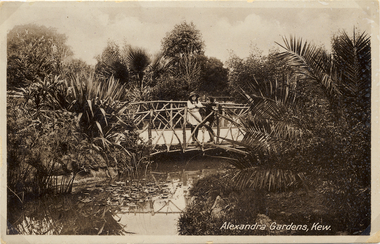
Postcard, Alexandra Gardens, Kew, 1910-1920
Named after Queen Alexandra, these beautiful gardens opened in 1908 and are designed in the formal style typical of the early 1900s.Early postcard showing architectural features and original plantings.The Alexandra Gardens, Cotham Road Kew. The postcard depicts a pedestrian bridge within the Gardens. The bridge, on which are standing two children, has rustic sides. On the evidence of this postcard, planting within the Gardens included a range of exotic specimens including a variegated aloe and water lilies. Native vegetation can be seen in the distance.alexandra gardens - kew (vic), postcards -- kew (vic.) -
 Kew Historical Society Inc
Postcard, Alexandra Gardens, Kew, 1908-1918
Named after Queen Alexandra, these beautiful gardens opened in 1908 and are designed in the formal style typical of the early 1900s.Early postcard showing original architectural features and plantings.The Alexandra Gardens, Cotham Road Kew. The postcard depicts a pedestrian bridge within the Gardens. The bridge, on which are standing two children, has rustic sides. On the evidence of this postcard, planting within the Gardens included a range of exotic specimens including a variegated aloe and water lilies. Native vegetation can be seen in the distance.alexandra gardens - kew (vic), postcards -- kew (vic.) -
 Kew Historical Society Inc
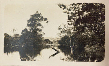
Photograph - Yarra River, Kew, 1924
Henry Beater Christian (1886-1962) , was a descendant of one of the earliest settler families in Kew. Employed at the Kew Asylum as a 'public servant', he was a skilled amateur photographer, photographing numerous scenes in Kew and on his travels around Victoria. The majority of his photographs date from 1916 to 1929. His finest photographs are housed in two photograph albums. A dated early photograph of the Yarra River at Kew.Digital copy of a photograph from page 1 of the 47-page photograph album containing 261 gelatinous silver images, loaned by Diane Washfold with permission given to digitise and hold a copy in our collection. The image is of the Yarra at Kew, looking upstream with native vegetation on either bank. There is a wooden fence on the left bank."Yarra River Kew 1924"henry beater christian (1886-1962), landscape photography, kew (vic.) — yarra river, christian-washfold collection, photograph albums -
 Hume City Civic Collection
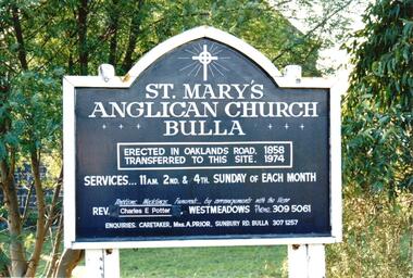
Photograph, late 1990s
St. Mary's Anglican Church at Bulla was originally built on the outskirts of Bulla township in 1858. In the early 1970s it was moved to its present site to make way for the flight path at the newly constructed Tullamarine Airport. The former site was on the corner of Oaklands and Sunbury Roads and is covered with vegetation. The church was designed by Thomas Taylor.A coloured photograph of the board which is along the fence line outside St. Mary's Church at Bulla. The white writing is on a navy blue background and is framed in white. The notice gives details of services, clergy and caretaker.churches, religion, anglican church, taylor, thomas, potter, charles e. rev., prior, a., st. mary's anglican church, george evans collection -
 Hume City Civic Collection
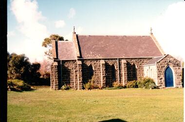
Photograph, late 1990s
St. Mary's Anglican Church at Bulla was originally built on the outskirts of Bulla township in 1858. In the early 1970s it was moved to its present site to make way for the flight path at the newly constructed Tullamarine Airport. The former site was on the corner of Oaklands and Sunbury Roads and is covered with vegetation. The church was designed by Thomas Taylor.A profile view of the west side of St. Mary's Anglican Church at Bulla and the garden area around the church. A slate covered gable roof has been constructed over the porch nave and chancery with a cross at each end of the roof over the nave. 6 bluestone buttresses and 3 lance windows are along the side with 3 small lancet windows and a blue painted wooden lancet door on the porch.churches, religion, taylor, thomas, st. mary's anglican church, george evans collection -
 Greensborough Historical Society
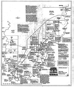
Map, Heidelberg: Historic River Landscape Assessment. Historical maps. Map D 1864 -1901 "Sleepy Hollow" and "Sleeping beauty", 1985c
Geographical area of c. 35 sq. kilometres marked with physical features such as major roads, rivers, vegetation and properties, with locations and notes on the increasing number of farms, orchards and vineyards that had been developed in addition to pastoral runs. Bounded by Shire of Diamond Valley to the North, Darebin Creek to the West, and Plenty River to the East.Black and white sketch on white paper. Second copy 600 x 430 cm printed in black on semi-opaque paperheidelberg, heidelberg - maps -
 Greensborough Historical Society
Map, Heidelberg. Historic River Landscape Assessment. Historical maps: Map C 1851-1863. "The Garden of the colony", 1985c
Geographical area of around 35 sq. kilometres marked with physical features such as major roads, vegetation and properties, with locations and notes of the increasing number of farms, gardens orchards and vineyards which had become established in addition to pastoral runs. Bounded by Shire of Diamond Valley to the North, Darebin Creek to the West and Plenty River to the East.Black and white sketch map on white paperheidelberg, heidelberg - maps -
 Eltham District Historical Society Inc
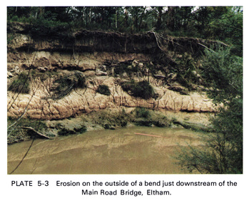
Work on paper (Sub-Item) - Photograph, Erosion on the outside of a bend just downstream of the Main Road Bridge, Eltham
Colour photograph of a muddy Diamond Creek (probably after a downpour) with siginificant water erosion apparent at the bend of the creek in Eltham.eltham, creek, vegetation, diamond creek, erosion -
 Lakes Entrance Regional Historical Society (operating as Lakes Entrance History Centre & Museum)
Book, Parks Victoria Compiler, Gippsland Lakes Algal Bloom Seminar Discussion Papers, 2003
A draft plan for the startegies to manage the Macleod Morass and Jones Bay Wildlife reservesenvironment, fauna, natural resources, restoration, vegetation -
 Lakes Entrance Regional Historical Society (operating as Lakes Entrance History Centre & Museum)
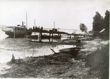
Photograph, 1886c
This is the paired before paired photograph used in the 150 year Lakes Entrance 1858-2008 display.|The after paired photograph number is 01464.1|Also one 12 x 16 framed photograph used in room display.Black and white photograph of the foreshore, showing a small steamer moored at a rough timber jetty, known as 'the Landing' (later Barrier Landing). Three small rowing boats moored to jetty loading fish to steamer identified as ss Bogong. Five men on jetty. Sandy shore strewn with dead seaweed, coastal banksia on bank. Lakes Entrance Victoriajetties, waterfront, boats and boating, vegetation, room display -
 Otway Districts Historical Society
Photograph, Les Ogden, Crowes track being dismantled at ashpit, 1961, 1961
On the Colac-Beech Forest-Crowes railway line the section from Ferguson to Crowes was closed in December 1954, but reopened as far as Weeaproinah in January 1955. The section to Crowes, left to its own devices, was rapidly covered with vegetation which had to be cleared when rail recovery trains later ran. The track to Crowes was pulled up in 1961. Crowes track being dismantled at the ashpit ready for loading into NQR wagons. colac; beech forest; crowes: railway; -
 Port of Echuca
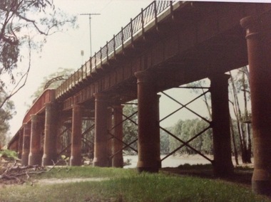
A rectangular coloured photograph, 1970?
This photograph shows the Echuca Moama bridge crossing the Murray River in the early 1970's. This photograph shows the Echuca Moama bridge in the early 1970's. It shows one of the rounded arches on the bridge. The rounded arches were the original arches and were at one stage replaced by square arches, but then replaced again by rounded arches.A rectangular coloured photograph of the Echuca Moama bridge taken from the Victorian bank, sometime in the early 1970's. One round bridge arch can be seen and a tall electricity pole can also be seen on top of the bridge. The vegetation on the Victorian bank is short and cropped. Some dead branches lie on the ground in the left foreground.There are none.echuca moama bridge, murray river, victorian bank -
 Stawell Historical Society Inc
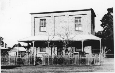
Photograph, Literary Institute at Pleasant Creek
Literary Institute at Pleasant Creek, Stawell West. The 1862 building has had many renovations over time. These 3 black & white photos show small changes over time. 3 B/W Photographs of two story brick building at Pleasant Creek, Stawell Literary Institute. Photos (found in Album 13, p.81) show three different views of the building and taken at different times judging by the vegetation around the building. One of the photos has a different fence what looks to be freshly painted. stawell -
 Lakes Entrance Regional Historical Society (operating as Lakes Entrance History Centre & Museum)
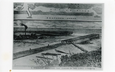
Photograph, 1880c
Photographic reproduction of woodcut drawing of the building of the entrance and map above of location.Black and white photograph of a woodcut showing dredge working between timber constructed piers on entrance from the lakes to the ocean Bass Strait. Piers unfinished, timber lying around, sand in the entrance. Map above showing position of the lakes, old and new entrances, southern ocean and sand dune vegetation. Lakes Entrance VictoriaA woodcut depicting the making of the Lakes Entrance.public works, dredging, houses, waterways -
 Lakes Entrance Regional Historical Society (operating as Lakes Entrance History Centre & Museum)
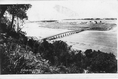
Postcard, 1888c
Black and white postcard of wooden bridge across the North Arm, showing sand hummocks Cunninghame Arm, Club Hotel, and die back of melaleuca on mudflats, caused by salination of Lakes after artificial entrance opened 1889. Vegetation on Kalimna Hill in foreground. Steamer on Cunninghame Arm centre top of photo. Lakes Entrance VictoriaCunninghame N Cairebridges, topography, township -
 Kew Historical Society Inc
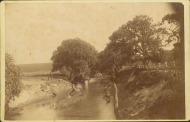
Photograph - Bryants Creek, Coleraine, 1892-3
This item is part of a larger collection donated to the Kew Historical Society by Anna French. The collection includes personal items from the donor's family, as well as items given to the donor and her mother by a family friend, Lucy Merritt (Jean) Hornby. The item is from that part of the collection inherited or assembled by Jean Hornby. The collection is significant given Jean Hornby's mother's descent from Robert Hornby (1854-1935) and Eva Merritt (1865-1959); her mother the chid of a family who settled in Kew in the 1850s, thus providing a chain of provenance for items dating to the mid-nineteenth century, when her maternal forebears arrived in Melbourne. Other items represent Jean Hornby's contribution to her local and wider community.Sepia photograph, labelled 'BRYANTS CREEK' at lower left. The creek is bordered by a white post and rail fence on one bank. On the other side of the creek are two men. The creek is bordered with remnant vegetation [ie Eucalypts]. Coleraine, in Western Victoria, was initially settled by Europeans in the 1840s. The developing township was aligned with Bryant's Creek with a north-south orientation. Reverse - Inscribed in ink: "Taken by H Bower with Student camera" / Printed: "C.G. Greenham Photographer, Hawthorn / The Herodotus Studio"bryants creek -- coleraine (vic.) -
![Fern Grove, near Mount Munday / [by] Nicholas Caire, circa 1876](/media/collectors/550653872162f11fb04854aa/items/57774d68d0cdd10a5c144296/item-media/57774e07d0cdd10a5c148099/item-fit-380x285.jpg) Kew Historical Society Inc
Kew Historical Society IncPhotograph, Anglo-Australasian Photographic Company, Fern Grove, near Mount Munday, c. 1876
Nicholas Caire was born on Guernsey in the Channel Islands in 1837. He arrived in Adelaide with his parents in about 1860. In 1867, following photographic journeys in Gippsland, he opened a studio in Adelaide. From 1870 to 1876 he lived and worked in Talbot in Central Victoria. In 1876 he purchased T. F. Chuck's studios in the Royal Arcade Melbourne. In 1885, following the introduction of dry plate photography, he began a series of landscape series, which were commercially successful. As a photographer, he travelled extensively through Victoria, photographing places few of his contemporaries had previously seen. He died in 1918. Reference: Jack Cato, 'Caire, Nicholas John (1837–1918)', Australian Dictionary of Biography, National Centre of Biography, Australian National UniversityAn original, rare photograph from the series 'Views of Victoria: General Series' by the photographer, Nicholas Caire (1837-1918). The series of 60 photographs that comprise the series was issued c. 1876 and reinforced a neo-Romantic view of the Australian landscape to which a growing nationalist movement would respond. Nicholas Caire was active as a photographer in Australia from 1858 until his death in 1918. His vision of the Australian bush and pioneer life had a counterpart in the works of Henry Lawson and other nationalist poets, authors and painters.Albumen silver photograph mounted on board‘The subject of this illustration is situated in one of the wildest and most romantic places in the Gipps Land ranges, about midway between Mount Munday and Mount Juliet. The foliage in this locality is very luxuriant, comprising mostly Fern Trees which are interwoven with various descriptions of grasses and stunted Fern leaves. Beneath this mass of vegetation flows a branch of the Contentment Creek.’landscape photography - victoria, nicholas caire, ferngrove - victoria -
 Kiewa Valley Historical Society
Report - Alpine Study Area Volume 2 Maps, Land Conservation Council, 1970s
The Victorian Environmental Assessment Council and the former Environment Conservation Council (ECC) and Land Conservation Council (LCC) have completed 36 land use investigations over more than 35 years, including 27 regional reviews. They provide a framework for use of Public Land in Victoria. The Land Conservation Council was established by the Land Conservation Act 1970.These maps provide an assessment of the Alpine area at the time the maps were created. Some of the topics eg. Rainfall and water resources may change over the years thus providing a comparative analysis. Others may provide information for future development such as mineral exploration, building of a dam / tunnel etc.Blue box shaped folder containing 9 of 10 Maps of the Alpine Study Area produced by the Land Conservation Council. Maps include 1. Public land and descriptive blocks. 2. Physiography. 3. Topography. 4. Geology (missing). 5. Rainfall and water resources. 6. Vegetation 7. Land systems. 8. Recreation. 9. Primary production. 10. Minerals Ex library item. Stamped in red "Discarded From Stock / Swan Hill Regional Libraryalpine area, maps of alpine area, land conservation council -
 Warrnambool and District Historical Society Inc.
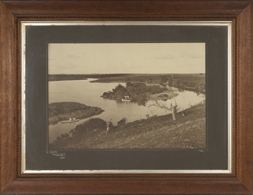
Photograph - Framed Photograph of the Islands in the Hopkins River, Jordan Studios, Warrnambool, 1911
This photograph shows the islands in the Hopkins River in 1911. This section of the river is in the Allansford area, near Jubilee Park (Hopkins River Caravan Park). It was, and still is, a picnic and fishing spot. On one of the islands is an unmarked grave which may be that of Jemima Christine Allan, the first wife of one of the first European settlers in the Allansford area, William Allan. She died in 1842. The photograph was taken by Jordan Studios so the photographer may be either Joseph Jordan, one of the best-known Warrnambool photographers of the past, or his son Arthur, also a well-credentialled photographer.This photograph is considerable historical importance, showing a section of the Hopkins River in the Warrnambool region in 1911.This is a black and white photograph in a wooden frame with a patterned edging. The photograph is inset with a gilt metal edging and enclosed in glass. The backing is wooden with a wire cord for hanging. The photograph shows the river with islands covered in vegetation. On the river are two boats, one wuih four occupants standing up in the boat and the other with two occupants. In the ccntre of the photograph is a tree stump and a dead tree.The Islands Hopkins River Warrnambool 1911 Jordan Photohopkins river, jemima allan, jordan studios -
Glenelg Shire Council Cultural Collection
Painting, Elizabeth King, On the Edge, 2004
Exhibited by the artist at the Wood, Wine & Roses Festival, Heywood, 2004.Acrylic paint on canvas depicting birds and fish, water lilies and other vegetation, and stylised designs associated with early settlement of Aboriginal people in the Portland/Glenelg wetland area. Black painted border with white dot pathways, a circle of white dots in each of the four corners. Centre area in blues and greens featuring two birds, painted in black with red and ochre bandings.Front: nil -
 Kew Historical Society Inc
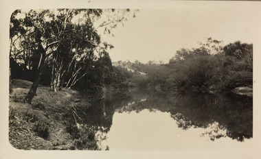
Photograph - Yarra River, Studley Park, 1924
Henry Beater Christian (1886-1962) , was a descendant of one of the earliest settler families in Kew. Employed at the Kew Asylum as a 'public servant', he was a skilled amateur photographer, photographing numerous scenes in Kew and on his travels around Victoria. The majority of his photographs date from 1916 to 1929. His finest photographs are housed in two photograph albums. Digital copy of a photograph from page 9 of the 47-page photograph album containing 261 gelatinous silver images, loaned by Diane Washfold with permission given to digitise and hold a copy in our collection. The point-of-view selected by the photographer, Henry Christian, was the stretch of the Yarra at Studley Park. In selecting this view he concentrates on the tranquility of the river and the remnant vegetation that lines the banks. "Studley Park / Kew"henry beater christian (1886-1962), landscape photography, kew (vic.) — yarra river, christian-washfold collection, photograph albums, yarra river -- studley park (vic.) -
 Sunbury Family History and Heritage Society Inc.
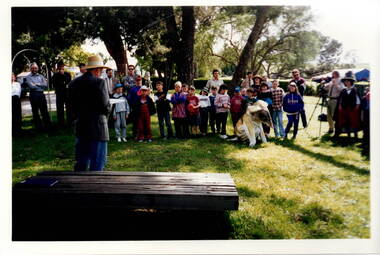
Photograph, c1989
The children from Bulla Primary School were taken on an excursion to Gellibrand hill Park which is a short distance from the School. The emphasis on the day's excursion was to identify the native fauna in the park as well as the vegetation.The property was originally settled by the Greene family in 1843. In 1980 the State Government purchased the property and it is now one of the state's parks where the natural vegetation has gradually been restored on the property. A non-digital coloured photograph of a group of adults and children listening to a man who is standing in front of a low seat and talking to them. There are buildings visible in the background. gellibrand hill, bulla primary school, school excursions -
 Ballarat Diocesan Historical Commission
photograph, Tower Hill Koroit photograph
Tower Hill at Koroit in Victoria was stripped of vegetation by generations of farming practices until replanting and regeneration programs were undertaken from the late 1960s onward. This historic image taken by keen amateur photographer and editor of the journal "Light", Monsignor J. Mc Inerney, shows the caldera before the replanting took place. Monsignor McInerney's photographic archive contains many images used in illustrating the journal. -
 Bayside Gallery - Bayside City Council Art & Heritage Collection
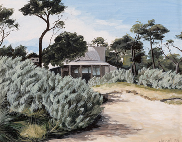
Painting - oil on canvasboard, Janet Green, Ricketts Point Tea House, 1989
Janet Green, Ricketts Point Tea House 1989, oil on canvasboard, 18.5 x 23.8 cm. Bayside City Council Art and Heritage Collection.ricketts point, beaumaris, bayside, janet green, tea house, vegetation -
 Bayside Gallery - Bayside City Council Art & Heritage Collection
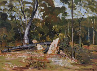
Work on paper - gouache on paper, Ian Armstrong, Wedderburn landscape, 1972
Ian Armstrong, Wedderburn landscape 1972, gouache on paper, 54 x 73.5 cm. Bayside City Council Art and Heritage Collectiongouache on paperwedderburn, landscape, ian armstrong, tree, vegetation, rural -
 Bendigo Historical Society Inc.
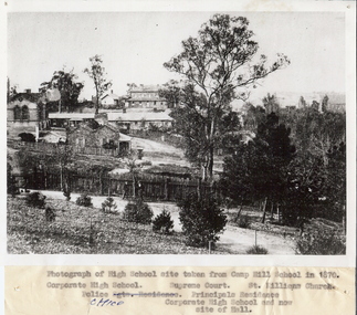
Photograph - HIGH SCHOOL SITE, TAKEN FROM CAMP HILL SCHOOL, 1870
Black and white photograph of high school site taken from Camp Hill School in 1870, looking North East. Inscriptions: Identification of buildings typed on attached paper. Far left is the Corporate High School, the Police Office is the long building, the Supreme Court building at read and the Principal's residence towards the foreground. The vegetation and path in the front is now part of the Camp Hill Primary School.place, landscape view -
 Whitehorse Historical Society Inc.
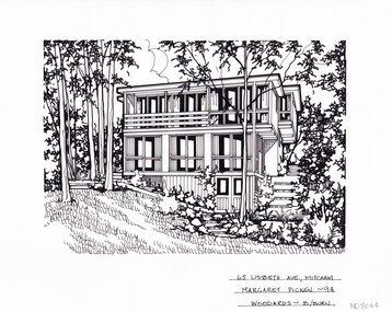
Artwork, other - Ink Line Drawing, Margaret Picken, 65 Lisbeth Ave., Mitcham, 1994
A property illustration by Margret Picken Commissioned by a real estate agency for the purpose of advertising 65 Lisbeth Ave., Mitcham This property is listed as having sold for $152,000 in 1994 Made by using Rotring ‘Rapidigraph’ drafting pens with Rotring ink on Rapidigraph polyester drafting film, double matte. Trained as a cartographic draftsman within the mining industry, Margaret Picken is an artist who worked producing property illustrations for real estate agencies in eastern suburbs of Victoria from 1983-2005. Retiring from the industry as technological changes favored coloured photography over illustrations, and commissioning companies over sole contractors.This artwork is of Historical Significance as a record of local domestic architecture.A black ink line drawing on drafters film by Margaret Picken, of 52 Lisbeth Ave., Mitcham depicting a black and white line drawing of a three story house made up of rectangular sections, staggard up a sloop. there is a set of stair up the sloop on the right of the house, and a lawn in the foreground, surrounded by encroaching vegetation. There are two holepunch holes centered just under the upper edge52 Lisbeth Ave., Mitcham Woodards - b/burn - M.Pickenwhitehorse historical society, schwerkolt cottage, housing, architecture, margaret picken, house, garden, real estate, mitcham -
 Lakes Entrance Regional Historical Society (operating as Lakes Entrance History Centre & Museum)
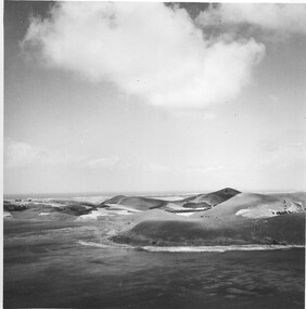
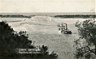
Photograph, Segerberg and Bulmer, 1910 c
Also enlargement 17 x 23 cmBlack and white photograph showing view from Jemmys Point of the entrance to the Gippsland Lakes from Bass Strait. Pioneer dredge in centre foreground, and steamer JCD. Cottages and works buildings including Rocket shed on eastern dunes, Schnapper Cottage on far right western dune. Rock groynes and tip of Bullock Island centre left. Vegetation in foreground. Lakes Entrance VictoriaLAKES ENTRANCE Segerberg and Bulmerships and shipping, topography, jetties, houses -
 Lakes Entrance Regional Historical Society (operating as Lakes Entrance History Centre & Museum)
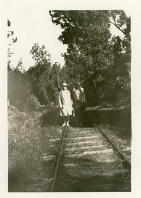
Photograph, 1930c
1 x copy black and white 15.5 x 11|1 copy sepia 14.5 x 10Black and white photograph of the tramway on which the granite rock was transported from the Mississippi Creek quarry to the head of the North Arm. It shows portion of the 3 foot 6 inch, 105cm, track, which had a gentle gradient, achieved with cuttings where necessary, winding between thick natural vegetation. Two women standing on track dressed in 1930 style clothing. Lakes Entrance Victoriatransport, quarries, room display -
 Lakes Entrance Regional Historical Society (operating as Lakes Entrance History Centre & Museum)
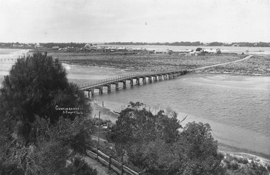
Photograph, 1908c
2/ Also 1x Black and white print of same 8.5x13.5 P01150-2Sepia tone and Tinted photograph of wooden bridge across North Arm, showing a distant view of the town, Cunninghame Arm and sand hummocks, and a view of the North Arm, small wooden bridge connecting to mud island. In foreground gravel road,and post and rail fence and native vegetation. Telegraph poles on either side of North Arm. Photo mounted on heavy card. Lakes Entrance VictoriaCunninghame A Cooperbridges, roads and streets, fences