Showing 5515 items matching "boroondara"
-
 Kew Historical Society Inc
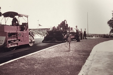
Photograph, Public Works, Road Construction, 1950s
An original photograph donated to the Kew Historical Society by the City's Engineering Department before the amalgamation of Kew into the City of Boroondara in 1994.While not all of the photographs are of Studley Park, Kew or East Kew, each photo provides a fine snapshot of the work of local government engineering departments of the period. They reveal they types of labour conducted, the techniques used and the equipment and machinery in the possession of the local government authority. Public works. Road making in the 1950s using a steam roller and a mechanical grader. Inscription on reverse: "Road making." city of kew (engineering department), road construction building, road maintenance -
 Kew Historical Society Inc
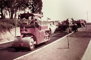
Photograph, Public Works, Road Construction, 1950s
An original photograph donated to the Kew Historical Society by the City's Engineering Department before the amalgamation of Kew into the City of Boroondara in 1994.While not all of the photographs are of Studley Park, Kew or East Kew, each photo provides a fine snapshot of the work of local government engineering departments of the period. They reveal they types of labour conducted, the techniques used and the equipment and machinery in the possession of the local government authority.Public works. Road making in the 1950s using a steam roller and a mechanical grader. Inscription on reverse: "Road making." city of kew (engineering department), road construction -
 Kew Historical Society Inc
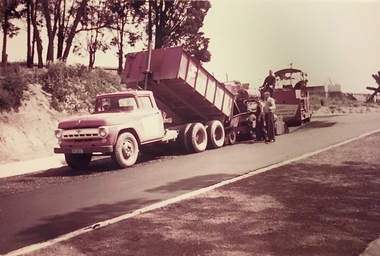
Photograph, Public Works, Road Construction, 1950s
An original photograph donated to the Kew Historical Society by the City's Engineering Department before the amalgamation of Kew into the City of Boroondara in 1994.While not all of the photographs are of Studley Park, Kew or East Kew, each photo provides a fine snapshot of the work of local government engineering departments of the period. They reveal they types of labour conducted, the techniques used and the equipment and machinery in the possession of the local government authority.Public works. Roadmaking machinery in the 1950s using a tip truck and other equipment. Inscription on reverse: "Road making. Date?" city of kew (engineering department), road construction maintenance -
 Kew Historical Society Inc
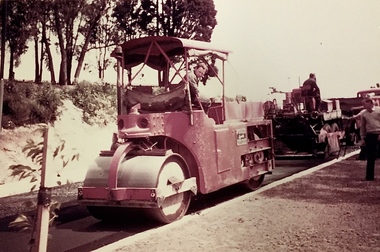
Photograph, Public Works, Road Construction, 1950s
An original photograph donated to the Kew Historical Society by the City's Engineering Department before the amalgamation of Kew into the City of Boroondara in 1994.While not all of the photographs are of Studley Park, Kew or East Kew, each photo provides a fine snapshot of the work of local government engineering departments of the period. They reveal they types of labour conducted, the techniques used and the equipment and machinery in the possession of the local government authority.Public works. Roadmaking in the 1950s using a steam roller. Inscription on reverse: "Road making. Date?" city of kew (engineering department), road construction building -
 Kew Historical Society Inc
Archive (Sub-series) - Subject File, Kew Historical Society, Hotels, 1958
Various partiesReference, Research, InformationSecondary Values (KHS Imposed Order)Subject file containing primary and secondary sources relating to each hotel in Kew, including the Woodman Inn, Clifton Hotel, Greyhound Hotel, Princess Hotel, Harp of Erin, Kew Hotel, and the Council Family Hotel. Each file includes correspondence, histories, etc. The general section of the archive file includes a copy of McWilliam, Gwen, ‘Hotels, Vineyards and Licenses in Boroondara & neighbourhood in the Nineteenth Century (revised 1998) [21 pages]. The earliest original document is an original bound contract with costings, provided by E S Clementson Pty Ltd (1956) to Robert H McIntyre & Associates for rebuilding the Harp of Erin Hotel.kew - history, hotels - kew (vic), prospect hill hotel, clifton hotel - kew junction, greyhound hotel, woodman inn, harp of erin hotel, kew hotel,, e s clementson pty ltd, architects - melbourne, robert mcintyre - architectkew - history, hotels - kew (vic), prospect hill hotel, clifton hotel - kew junction, greyhound hotel, woodman inn, harp of erin hotel, kew hotel,, e s clementson pty ltd, architects - melbourne, robert mcintyre - architect -
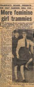 Melbourne Tram Museum
Newspaper, "More feminine girl trammies", "Flagging a new day", 4/07/1995 12:00:00 AM
Set of two newspaper clippings collected by Olive Bailey. .1 - newspaper clipping from a 1967 newspaper (possibly Feb. March 1967) based on the photograph and caption on the rear) or new conductresses uniforms being designed and modelled for the MMTB use by Olive Bailey and Ursula Heyda. Quote Chairman Mr. R. Risson. Notes uniforms similar to those of the Hamburg Germany. .2 - Newspaper clipping from a Boroondara region paper, 4-7-1995, titled "Flagging a new day", with Olive Leamon showing her collection of flags at her house in Hawthorn. Item written by Maria Harris, photos Simon Schulter.trams, tramways, conductors, conductresses, personnel -
![Photograph - Digital Photographs [Series], Robert Baker, Display: Kew High School, Kew Library, 2013, 2013](/media/collectors/550653872162f11fb04854aa/items/5c2dae7321ea6908dc9197e4/item-media/5c2daed521ea6908dc9208a5/item-fit-380x285.jpg) Kew Historical Society Inc
Kew Historical Society IncPhotograph - Digital Photographs [Series], Robert Baker, Display: Kew High School, Kew Library, 2013, 2013
The Kew Historical Society mounts regular exhibitions at venues throughout Boroondara. These generally relate to Kew's History and use items from the collection.Three born digital images of an exhibition of items significant to the history of Kew High School. The exhibition was curated by Val Bourke of the Kew Historical Society, and located in the Kew Library.kew high school, exhibitions -- kew (vic.), kew library -
![Borough of Kew - Gazetted Streets [1865-1937]](/media/collectors/550653872162f11fb04854aa/items/59614050d0cdd511a09c84a0/item-media/59614577d0cdd511a09e80c0/item-fit-380x285.jpg) Kew Historical Society Inc
Kew Historical Society IncDocument, Borough of Kew / Gazetted Streets, 1865-1937
The Melbourne suburb of Kew gained independence from the Boroondara Roads Board in 1860, being declared a Municipality in that year. Kew became a Borough in 1863, a Town in 1910, and a City in 1921. The former City of Kew became part of a newly declared City of Boroondara in 1994. This very fragile document records the following information about streets in Kew - Name, Total Width, Width of Carriageway, Description, Government Gazetted - Year & Page.While the name of a street was formally acknowledged and published in the Victorian Government Gazettes, this document, compiled by a public officer, probably in the Town Clerk's Department, is the earliest known local record listing street names in the Borough, later Town, then City of Kew. The front page indicates that in 1865, the responsibility for an initial 36 streets in Kew was taken over by Council. The final annotation in the document was made in 1937. The document is an important record for researchers seeking to understand the dating of streets in the district.27-page document compiled by officers of the Borough, Town and City of Kew, listing the names of streets taken over by Council, and providing details of their proportions and gazettiing. The document covers the period of 1865 to 1937. Handwritten documentborough of kew, streets -- kew (vic.) -
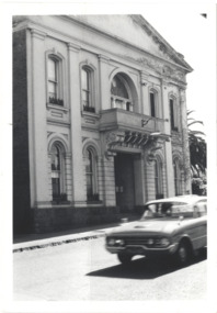 Kew Historical Society Inc
Photograph - Former Kew Town Hall, Walpole Street, 1970
The Municipality of Kew was granted independence in 1860. It was declared a borough in 1863, a town in 1910 and a city in 1921. In 1994, Kew was amalgamated into the new City of Boroondara.Black and white photographic positive of the front of the (former) Kew Town Hall in Walpole Street between High Street and Malmsbury Street, on the west side where Woolworth's supermarket now stands. The photograph, from August 1970 shows the detailing of the Italianate rendered-brick facade, added in the 1880s when the hall was renovated. The earliest building on the site was the Kew Athenaeum Hall (built 1860) which was purchased by Kew Council in 1865. The Town Hall was sold to Woolworth's and subsequently demolished in 1972 when the civic offices were transferred to a new building on the corner of Charles Street and Cotham Road."Old Kew Town Hall / Walpole St / Aug 1970/ Gift of Stewart West 1990"kew town hall -- walpole street, local government -- kew, civic buildings -- kew (vic.), town halls -- melbourne (vic.) -
Canterbury History Group
Document - The foundation of our city, Renwick, Reg, c1973
A paper read to Camberwell Historical Society by Mr Reg. Renwick describing the part played by the Boroondara Road Board in the development of Camberwell and surrounding areas.4 foolscap pagescanterbury, camberwell, kew, hawthorn, boroondara road board, roads, tollhouses, palmer> sir james, affleck> john, box> henry, brooks> thomas, lavis> george, lynch> mkichael, pettett> william henry, stobie> david, wade> william henry, walsh> henry sellars, withers> john -
Canterbury History Group
Document - Guidelines for local history research, Gwen McWilliam, December 1988
Brochure and article for talk to the Camberwell Historical Society providing guidelines and lists of resources for local history research. Includes list of sources relating to BoroondaraA3 folded sheet, 14 typewritten A4 pages and covering lettercamberwell historical society, research, city of boroondara -
Kew Historical Society Inc
Archive (Sub-series) - Subject File, Kew Historical Society, Horse Trough & Hitching Post [Kew], 1966
Various partiesReference, Research, InformationSecondary Values (KHS Imposed Order)Correspondence and published articles relating to the horse trough and hitching post outside the gates of the Boroondara General Cemetery. The earliest item of correspondence is a typed and signed letter from the historian Dorothy Rogers to Mrs West, Secretary of the Kew Historical Society, dated 13 Feb 1966. It relates to transport, including horse trams that travelled through Kew. Another letter from B F Bade in 1986 identifies the hitching post as having been once located outside the old Kew Town Hall in Walpole Street, and dating from 1907. The latter was acquired in 1987 and installed in 1988 during the Bicentennial. The horse trough was originally located on this site and restored in 1988.kew historical society - archives, kew - history, boroondara general (kew) cemetery, george bills, annis bills, horse transport - melbournekew historical society - archives, kew - history, boroondara general (kew) cemetery, george bills, annis bills, horse transport - melbourne -
 Melbourne Tram Museum
Document - Personal Papers, H. S McComb, "Gazette", 1920's
Set of quarto hand written sheet pinned together for each year with some typed sheets, listing notices in the Victorian Government Gazette of non-Melbourne suburban tramways - timber tramways, proposed lines. Items for 1898 and 1898 - carbon copies. 1885 - Ballarat and the Grand Fern Tree Gully Hotel 1886 - Ballarat, Coburg, Moorabbin and Ballarat 1887 - Beaumaris, Koondrook, Swan Hill, Sorento, Eaglehawk, Sandhurst (Bendigo) Ballarat, Yarrawonga, Warragul, Coburg 1888 - Ballarat, Eaglehawk, Geelong, Coburg, Moorabbin, Caulfield, Northcote 1889 - Ballarat, Bullen, Boroondara, Nunawading, Northcote 1890 - Moorabbin, Caulfield, Traralgon, Oakleigh 1898 - Northcote, 1899 - Northcotetrams, tramways, tramways, government gazette, ballarat, coburg, moorabbin, bendigo, geelong, northcote -
Canterbury History Group
Document - Comments on Boroondara Thematic Environmental History Draft document, Canterbury History Group, 1/08/2011 12:00:00 AM
Comments by some concerned members of the Canterbury community regarding issues relating to Canterbury resulting from a careful study of the draft consultation document prepared for the City of Boroondara.canterbury, visions of a village, education, libraries, stationmasters house, petrol stations, canterbury road shopping centre, maling road shopping centre, theatres, police stations, canterbury gardens, railways -
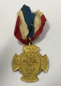
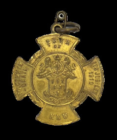 Kew Historical Society Inc
Medal, Town of Kew : To Commemorate its Jubilee, 1910
Medal issued to commemorate the 50th jubilee of the Town of Kew. It names J.F. McCrea as Mayor. John Falding McCrea was Mayor of Kew 1910-11. Kew was proclaimed a municipality on 22 December 1860, seceding from the Boroondara Road Board District, then comprising Kew, Hawthorn and Camberwell. It was proclaimed a town on 8 December 1910, the year this medal was issued, and a city on 10 March 1921. On 22 June 1994 Kew city was united with Camberwell and Hawthorn cities to form Boroondara city. (MV)Gilt bronze Town of Kew Jubilee medal in the shape of a Maltese Cross.Obverse description Shield of six wheat-sheafs above motto CRESCO on ribbon; above shield is the Royal coat of arms with lion and unicorn supporters and, on ribbon DIEU ET MIN DROIT; on arms of cross top, TOWN / OF, bottom, KEW, left TO COMMEM / -ORATE, right, ITS JUBILEE / 1910 Reverse description shield of six wheat-sheafs above motto CRESCO on ribbon; above shield is the Royal coat of arms with lion and unicorn supporters and, on ribbon DIEU ET MIN DROIT; on arms of cross top, TOWN / OF, bottom, KEW, left TO COMMEM / -ORATE, right, ITS JUBILEE / 1910town of kew jubilee (1910), commemorative medals - kew (vic), australian commemorative medals -
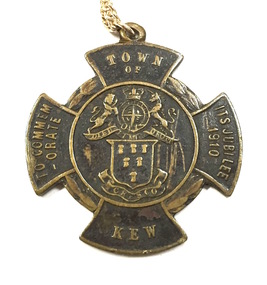
 Kew Historical Society Inc
Medal, Stokes & Sons, Town of Kew : To Commemorate its Jubilee, 1910
Medal issued to commemorate the 50th jubilee of the Town of Kew. It names J.F. McCrea as Mayor. John Falding McCrea was Mayor of Kew 1910-11. Kew was proclaimed a municipality on 22 December 1860, seceding from the Boroondara Road Board District, then comprising Kew, Hawthorn and Camberwell. It was proclaimed a town on 8 December 1910, the year this medal was issued, and a city on 10 March 1921. On 22 June 1994 Kew city was united with Camberwell and Hawthorn cities to form Boroondara city.Mint gilt medal with original ribbon.Kew Jubilee medal in the shape of a Maltese cross. Gilded bronze with attached original red, white and blue cloth ribbon. On the front is the Coat of Arms of the Town of Kew and an inscription: ‘Town of Kew. To Commemorate Its Jubilee 1910’. On the reverse is inscribed 'Kew Jubilee 1860-1910. Cr J.F. McCrae J.P. Mayor'. The medal was also issued in bronze.Obverse description Shield of six wheat-sheafs above motto CRESCO on ribbon; above shield is the Royal coat of arms with lion and unicorn supporters and, on ribbon DIEU ET MIN DROIT; on arms of cross top, TOWN / OF, bottom, KEW, left TO COMMEM / -ORATE, right, ITS JUBILEE / 1910 Reverse description Within line circle set at centre of cross shaped flan, CR. J.F. McCREA / J.P. / MAYOR on arms of cross, top, KEW bottom, JUBILEE, left 1860, right, 1910jubilee - kew (vic), commemorative medals - kew (vic), australian commemorative medals -
 Kew Historical Society Inc
Medal, Stokes & Sons, Town of Kew : To Commemorate its Jubilee, 1910
Medal issued to commemorate the 50th jubilee of the Town of Kew. It names J.F. McCrea as Mayor. John Falding McCrea was Mayor of Kew 1910-11. Kew was proclaimed a municipality on 22 December 1860, seceding from the Boroondara Road Board District, then comprising Kew, Hawthorn and Camberwell. It was proclaimed a town on 8 December 1910, the year this medal was issued, and a city on 10 March 1921. On 22 June 1994 Kew city was united with Camberwell and Hawthorn cities to form Boroondara city. (MV)This work forms part of the collection assembled by the historian Dorothy Rogers, that was donated to the Kew Historical Society by her son John Rogers in 2015. The manuscripts, photographs, maps, and documents were sourced by her from both family and local collections or produced as references for her print publications. Many were directly used by Rogers in writing ‘Lovely Old Homes of Kew’ (1961) and 'A History of Kew' (1973), or the numerous articles on local history that she produced for suburban newspapers. Most of the photographs in the collection include detailed annotations in her hand. The Rogers Collection provides a comprehensive insight into the working habits of a historian in the 1960s and 1970s. Together it forms the largest privately-donated collection within the archives of the Kew Historical Society.Bronze Town of Kew Jubilee medal in the shape of a Maltese Cross.Obverse description Shield of six wheat-sheafs above motto CRESCO on ribbon; above shield is the Royal coat of arms with lion and unicorn supporters and, on ribbon DIEU ET MIN DROIT; on arms of cross top, TOWN / OF, bottom, KEW, left TO COMMEM / -ORATE, right, ITS JUBILEE / 1910 Reverse description shield of six wheat-sheafs above motto CRESCO on ribbon; above shield is the Royal coat of arms with lion and unicorn supporters and, on ribbon DIEU ET MIN DROIT; on arms of cross top, TOWN / OF, bottom, KEW, left TO COMMEM / -ORATE, right, ITS JUBILEE / 1910town of kew jubilee (1910), commemorative medals - kew (vic), australian commemorative medals -
Surrey Hills Historical Society Collection
Work on paper - Vertical file, Beckett Park and Maranoa Gardens
1. ‘Observation tower Beckett Park’, B.H. Reporter, 23.11.1934 (2 pages). 2. ‘Glory of a native garden’, F. Chapman, Literary Section unknown paper, 2.9.1939 (1 page, 2 copies original and copy). 3. Copy ‘Centenary tower’, The Herald, 21.5.1937 (1 page). 4. ‘Maranoa’, Camberwell City News, August, 1990 (1 page). 5. ‘Rotary Club’s gift to garden’, ? Age, 1990s ? (1 page) 6. ‘Maranoa Gardens & Beckett Park’ supplement, Boroondara Bulletin, 1997 (2 page spread). 7. ‘Beckett Park revisited’ by Annie Gillison, 8.7.1985, Melbourne Week ? (1 page). 8. Maranoa gardens Boroondara Council brochure (undated) (1 page). 9. Re Mr. Arthur J. Swaby, information from various sources, undated (1 page). 10. Beckett Park – ‘Glory of a Native Garden’, F. Chapman, unnamed newspaper, 2.9.1939, copy. (1 page). 11. Beckett Park: information re Robert Beckett from various sources (2 pages). 12. ‘Most will like gardens plan’, unnamed newspaper, letter from Dennis Whelan, undated (1 page). 13. Extracts from J.A. Allan’s unpublished history of Camberwell re Beckett Park & Maranoa Gardens, undated (1 page). 14. Maranoa Gardens Self-guided walk, undated (4 page brochure). 15. Notes on F. Chapman and interests, various sources, (2 pages). 16. Empire Day celebrations, extract from Argus, 24.5.1937 (1 page). 17. Extract from Camberwell Conservation Plan, 1989 by McConville (1 page). 18. ‘A lesson in serenity’, Maranoa Botanic Gardens, Balwyn, Domain Review, 7.7.2021 (2 pages). 19. Boroondara City Council Notice of proposed naming of reserve, Progress Leader, 5.12.2019 (1 page). 20. Maranoa Botanic Gardens, undated (double sided pamphlet). 21. 2 extracts from Box Hill Recorder, 23.10.1925 and 27.11.1925 (1 page). 22. Extract from BHR, 15.1.1926 ‘Visit of Field Naturalists Club of Victoria’ (1 page). -
Kew Historical Society Inc
Badge - Identification Badges, City of Kew, Three City of Kew Swimming Pool Attendant Badges, 1950-1994
The first Kew Municipal Baths were opened in 1925. Since then a number of rebuildings have altered the position and size of the pool. The badge predates the amalgamation of Kew into the City of Boroondara in 1994.Three City of Kew Swimming Pool Attendant Badges. Shield shape nickel plated badges with pins.Kew Swimming Pool Attendantbadges, kew swimming pool - kew (vic), city of kew -
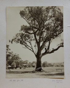 Kew Historical Society Inc
Photograph, Colin Campbell, The Old Gum Tree, 1961
In 1871, Victoria Park, beside the Boroondara General Cemetery was set aside as a public reserve. As the Park developed, exotic plants were added to existing specimens. In 1910, a photograph of ‘The Oldest Inhabitant: A Giant Red-gum Tree’ in the Park was included in the Jubilee History of Kew. Fifty-one years later the tree was re-photographed by Colin Campbell. A 2007 Master Plan developed for the City of Boroondara advises the retention of this now dead River Red Gum, including a ‘managed risk zone’ and planting under the heavily lopped tree.‘The Old Gum Tree’ in Victoria Park. In the distance a game of cricket is being played on the oval. The old grandstand can be seen in the photo. Photographer Colin Campbell 1961. THE OLD GUM TREE / COLIN CAMPBELL KEW 1961victoria park (kew), colin campbell (photographer), victoria park, red gum tree, eucalypts, kew (vic.) -- historic trees -
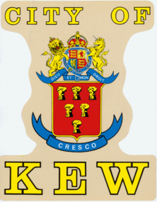 Kew Historical Society Inc
Sign, City of Kew Crest
The seal of the former City of Kew is held in the collection of the City of Boroondara, as is the Mayoral Chain of Office. The original design was circular and cast in high relief to allow impressions to be made. Later versions such as this modernise the style for a range of purposes.Four colour version of the City of Kew Crest, adopted by the Municipality in 1861 for use in its circular seal but later adapted as in this version for printing or for identification. There are two examples this version: both transfers designed to be affixed to Council vehicles. The collection includes 11 copies of the large transfers and one copy of the smaller version. The bright colours used were typical of the period. The large version is 375 x 295 mm; the smaller is 205 x 155 mm.CITY OF KEW / DIEU ET MON DROITcity of kew, crests, municipal crests -
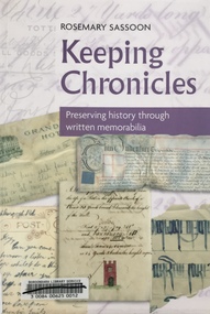 Kew Historical Society Inc
Book, Rosemary Sassoon, Keeping Chronicles: Preserving history through written memorabilia, 2010
160 p. : ill. ; 26 cm.non-fictionhistory - sources - preservation -
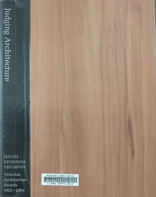 Kew Historical Society Inc
Book, Judging Architecture: Issues, Divisions, Triumphs, Victorian Architecture awards 1929-2003, 2003
Melbourne, Vic. : Royal Australian Institute of Architects, 2003 316 p. : ill. ; 29 cm. + poster (86 x 60 cm) non-fictionarchitecture - victoria - awards, architecture - history - victoria -
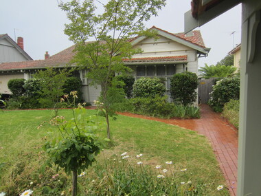
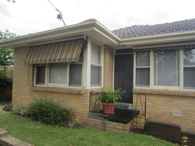
 Surrey Hills Historical Society Collection
Photograph - 109 Middlesex Road, Surrey Hills, The Street Where You Live Project
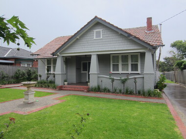
Photos documenting this address as part of a photographic series undertaken by volunteer photographers during 2013 and 2014 for The Street Where You Live Project. This was organised through the Surrey Hills Neighbourhood Centre and covered the postcode 3127 in the cities of Boroondara and Whitehorse.These photos provide a snapshot of real estate in the suburbs of Mont Albert and Surrey Hills during a period of rapid change with many properties on large blocks demolished to create higher density residential development or renewal of single dwellings. At particular risk were properties not covered by heritage overlays, in particular interwar housing and post 1950's housing. -
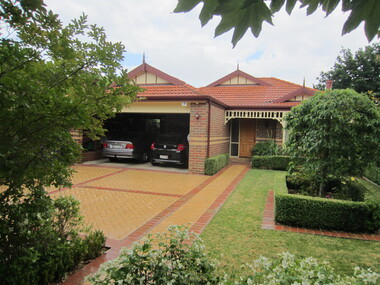
 Surrey Hills Historical Society Collection
Photograph - 110 Middlesex Road, Surrey Hills, The Street Where You Live Project
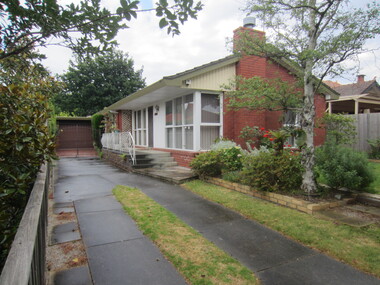
Photos documenting this address as part of a photographic series undertaken by volunteer photographers during 2013 and 2014 for The Street Where You Live Project. This was organised through the Surrey Hills Neighbourhood Centre and covered the postcode 3127 in the cities of Boroondara and Whitehorse.These photos provide a snapshot of real estate in the suburbs of Mont Albert and Surrey Hills during a period of rapid change with many properties on large blocks demolished to create higher density residential development or renewal of single dwellings. At particular risk were properties not covered by heritage overlays, in particular interwar housing and post 1950's housing. -
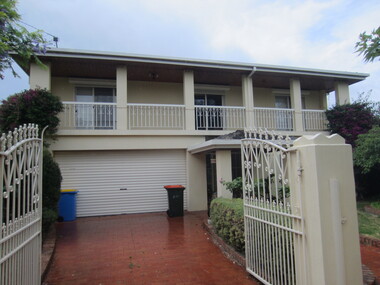
 Surrey Hills Historical Society Collection
Photograph - 111 Middlesex Road, Surrey Hills, The Street Where You Live Project
Photos documenting this address as part of a photographic series undertaken by volunteer photographers during 2013 and 2014 for The Street Where You Live Project. This was organised through the Surrey Hills Neighbourhood Centre and covered the postcode 3127 in the cities of Boroondara and Whitehorse.These photos provide a snapshot of real estate in the suburbs of Mont Albert and Surrey Hills during a period of rapid change with many properties on large blocks demolished to create higher density residential development or renewal of single dwellings. At particular risk were properties not covered by heritage overlays, in particular interwar housing and post 1950's housing. -
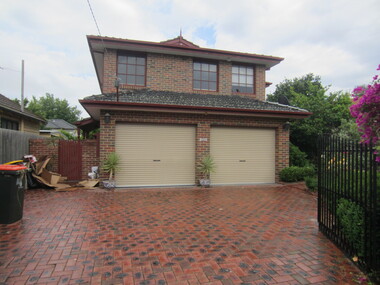
 Surrey Hills Historical Society Collection
Photograph - 112 Middlesex Road, Surrey Hills, The Street Where You Live Project
Photos documenting this address as part of a photographic series undertaken by volunteer photographers during 2013 and 2014 for The Street Where You Live Project. This was organised through the Surrey Hills Neighbourhood Centre and covered the postcode 3127 in the cities of Boroondara and Whitehorse.These photos provide a snapshot of real estate in the suburbs of Mont Albert and Surrey Hills during a period of rapid change with many properties on large blocks demolished to create higher density residential development or renewal of single dwellings. At particular risk were properties not covered by heritage overlays, in particular interwar housing and post 1950's housing. -
 Surrey Hills Historical Society Collection
Photograph - 113 Middlesex Road, Surrey Hills, The Street Where You Live Project
Photos documenting this address as part of a photographic series undertaken by volunteer photographers during 2013 and 2014 for The Street Where You Live Project. This was organised through the Surrey Hills Neighbourhood Centre and covered the postcode 3127 in the cities of Boroondara and Whitehorse.These photos provide a snapshot of real estate in the suburbs of Mont Albert and Surrey Hills during a period of rapid change with many properties on large blocks demolished to create higher density residential development or renewal of single dwellings. At particular risk were properties not covered by heritage overlays, in particular interwar housing and post 1950's housing. -
 Surrey Hills Historical Society Collection
Photograph - 114 Middlesex Road, Surrey Hills, The Street Where You Live Project
Photos documenting this address as part of a photographic series undertaken by volunteer photographers during 2013 and 2014 for The Street Where You Live Project. This was organised through the Surrey Hills Neighbourhood Centre and covered the postcode 3127 in the cities of Boroondara and Whitehorse.These photos provide a snapshot of real estate in the suburbs of Mont Albert and Surrey Hills during a period of rapid change with many properties on large blocks demolished to create higher density residential development or renewal of single dwellings. At particular risk were properties not covered by heritage overlays, in particular interwar housing and post 1950's housing. -
 Surrey Hills Historical Society Collection
Photograph - 115 Middlesex Road, Surrey Hills, The Street Where You Live Project
Photos documenting this address as part of a photographic series undertaken by volunteer photographers during 2013 and 2014 for The Street Where You Live Project. This was organised through the Surrey Hills Neighbourhood Centre and covered the postcode 3127 in the cities of Boroondara and Whitehorse.These photos provide a snapshot of real estate in the suburbs of Mont Albert and Surrey Hills during a period of rapid change with many properties on large blocks demolished to create higher density residential development or renewal of single dwellings. At particular risk were properties not covered by heritage overlays, in particular interwar housing and post 1950's housing.