Showing 408 items
matching camp sites
-
 Melbourne Legacy
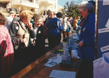
Photograph, Back to Caulfield 1995, 1995
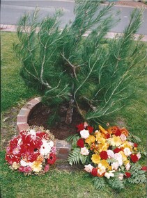
For many years Legacy had a "Back to Caulfield Race Day" for Legatees, widows and their families. 1995 was the 50th anniversary of the end of World War 2 and the race day was part of the "Australia Remembers" commemorations. Also a Legacy 'Lone Pine' was planted. The article in the Answer says: "Over 800 members of the Legacy family (past and present) reunite at the "Australia Remembers" Back to Caulfield Commemorative Race Day held on August 12th. It was a special day which incorporated a wide range of activities, including a display of military vehicles, a flyover, a parachute jump by the Red Berets, military bands, and displays of memorabilia when the racecourse was used as an army camp. An official ceremony also included the presentation of a Legacy 'Lone Pine' (a descendant of the Gallipoli 'Lone Pine') by the President of the Melbourne Legacy, Legatee David Millie, which was very warmly received by the Chairman of the V.A.T.C., Mr Peter Lawrence.Legacy retains a tie with Caulfield racecourse as it was once an army camp and staging post of young men going overseas to war and now it is the site of a lone pine. The annual gathering at Caulfield racecourse was an event that gets the Legacy family together.Colour photo x 3 of an event at Caulfield racecourse, and an article in The Answer.Printed on the back film number 786 No. 7A and No. 19A. Film number 787 No. 9A.events, wreath laying ceremony, answer -
 Melbourne Legacy
Photograph, Back to Caulfield 1996, 1996
For many years Legacy had a "Back to Caulfield Race Day" for Legatees, widows and their families. In 1995 a Legacy 'Lone Pine' was planted. The article in the Answer says: “We were delighted with the many Legacy Widows, Legatees and friends of Legacy who participated in the Commemorative Race Day at Caulfield Sunday 25th August - marking the 75th anniversary of the RAAF. The VATC had a range of displays and activities including a breathtaking parachute demonstration by the Blue Eagles. It was touch and go for a while due to the weather conditions but once the Blue Eagles jumped they all reached their designated target in front of the winning post. Legacy even had a special race named after it: “The Legacy Widows Appeal Handicap”. Our thanks to the VATC for this courtesy. Hope we had a few winners! Vice President, Legatee Brian ‘Lucky’ Luscombe placed a wreath at the legacy ‘Lone Pine’ - a descendant of the Gallipoli ‘Lone Pine’ on behalf of the Legacy Family. The historic tree was presented to Caulfield last year as part of the events to mark the 1995 Australia Remembers year.” The photos show children playing mini golf as well as the Historical Re-enactment Society of Australia with old military equipment and wearing old military uniforms. The racecourse also had a vintage plane on display with military vehicles.Legacy retains a tie with Caulfield racecourse as it was once an army camp and staging post of young men going overseas to war and now it is the site of a lone pine. The annual gathering at Caulfield racecourse was an event that gets the Legacy family together.Colour photo x 18 of an event at Caulfield racecourse in 1996 and an article in The Answer.Printed on back events, wreath laying ceremony, answer -
 Melbourne Legacy
Photograph, Back to Caulfield 1997, 1997
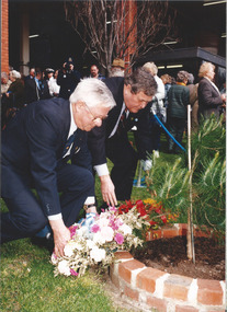
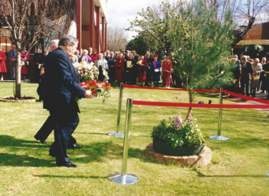
For many years Legacy had a "Back to Caulfield Race Day" for Legatees, widows and their families. In 1995 a Legacy 'Lone Pine' was planted. President Luscombe laid a wreath at the Lone pine tree. The article in the Answer says: "In spite of a somewhat 'windy' day for out "Back to Caulfield" race day, it was another success. Our President Legatee Brian (Lucky) Luscombe and Mr Peter Lawrence, Chairman of the VATC both made a speech and each laid a wreath at our 'Lone Pine' tree - a descendant of the Gallipoli 'Lone Pine'. Our pine tree was getting blown around ferociously, but its roots are firm - just like Legacy."Legacy retains a tie with Caulfield racecourse as it was once an army camp and staging post of young men going overseas to war and now it is the site of a lone pine. The annual gathering at Caulfield racecourse was an event that gets the Legacy family together.Colour photo x 7 of an event at Caulfield racecourse, and an article in The Answer.events, wreath laying ceremony, answer -
 Melbourne Legacy
Photograph, Back to Caulfield 1998, 1998
For many years Legacy had a "Back to Caulfield Race Day" for Legatees, widows and their families. In 1995 a Legacy 'Lone Pine' was planted. In these photos in 1998 President Tom Butcher laid a wreath at the Lone pine tree. There was a speech by the Legacy President and a wreath laying at the Lone Pine that had been planted in 1995. Legacy retains a tie with Caulfield racecourse as it was once an army camp and staging post of young men going overseas to war and now it is the site of a 'lone pine'. The annual gathering at Caulfield racecourse was an event that gets the Legacy family together.Colour photo x 13 of an event at Caulfield racecourse.Printed on the back film numbers 972 and 974. Yellow post it note said Back to Caulfield 1998.events, wreath laying ceremony -
 Mrs Aeneas Gunn Memorial Library
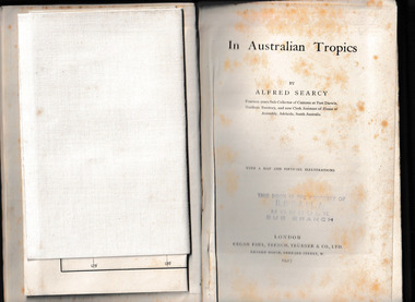
Book, Kegan Paul Trench Trubner and Co, In Australian tropics, 1907
Early history of N.T. and explorations; Detailed account of intercepting Macassan proas around coast of Arnhem Land whilst author was Sub-Collector of Customs for 14 years; Names of proas and masters, Malay camps & smoke houses along coast & nearby islands; Natives employed by Malays in trepang fishing and collecting tortoiseshell, relationships between Malays and Aborigines; influences (physical & cultural); Habit of exchanging children between tribes (Roper R. & Normanton) for the purpose of learning each others language & customs; Description of native camps at Fort Dundas (1895) shelters, finding of bark water bags, types of canoes used; Platform burial at Daly R.; Sacred burial site on Maria Island; Geographical features, vegetation, climate etc., general ecology, depredations & murders by natives; Cannibalism practiced by Fitzmaurice River tribes.Ill, maps, p.373.non-fictionEarly history of N.T. and explorations; Detailed account of intercepting Macassan proas around coast of Arnhem Land whilst author was Sub-Collector of Customs for 14 years; Names of proas and masters, Malay camps & smoke houses along coast & nearby islands; Natives employed by Malays in trepang fishing and collecting tortoiseshell, relationships between Malays and Aborigines; influences (physical & cultural); Habit of exchanging children between tribes (Roper R. & Normanton) for the purpose of learning each others language & customs; Description of native camps at Fort Dundas (1895) shelters, finding of bark water bags, types of canoes used; Platform burial at Daly R.; Sacred burial site on Maria Island; Geographical features, vegetation, climate etc., general ecology, depredations & murders by natives; Cannibalism practiced by Fitzmaurice River tribes. northern australia - description and travel, ethnography -
 Charlton Golden Grains Museum Inc
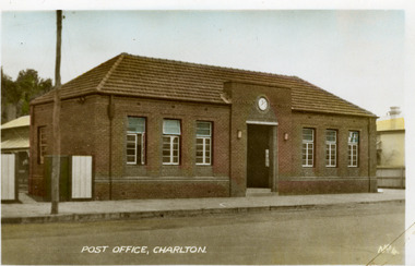
Photograph - Postcard, Charlton Post Office c. 1950s, c.1950
Charlton's third Post Office. The first was built in 1878 in Camp St, the second was an ornate brick building built in 1879 on the present site in High St. The third Post Office was built in 1941 as an upgrade to the earlier building.Postcard showing the brick Post Office building on High Street. Three windows on each side of the central entrance. Clock above the entrance. Signage above entrance Charlton Post Office. Telegraph pole and open gate on LH side of picture. Text at the bottom of the postcard says POST OFFICE, CHARLTON. No. 4.POST OFFICE, CHARLTON No. 4.charlton post office, charlton, business -
 Charlton Golden Grains Museum Inc
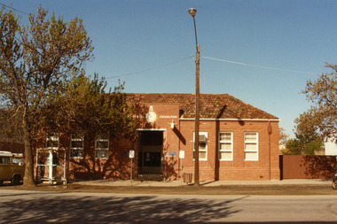
Photograph, Charlton Post Office 1987, c.1987
First Post Office established in Camp St in 1878. Rebuilt on current site in 1879, current Post Office built 1940. Photo part of a Charlton Shire streetscape series 1987.Colour photo of Charlton Post Office. Red brick single storey building. Clock above entrance shows 5 minutes to nine. Yellow combi van, tree and public telephone on LH side of photo. Street light and rubbish bin on right of entrance. Signage above entrance says Post Office Charlton, ER and crown above the clock. Brown fence to right of building,charlton post office, charlton, business, industry, post office -
 Tatura Irrigation & Wartime Camps Museum
Painting - Painting, Oil, Centaur, 1945
Harry Gorry bid for & purchased on internet auction site. The seller's mother was putting these & other items up for auction. Her father, the seller's grandfather was Dr. Bruno Koenig, a German surgeon detained by Allied forces while fleeing New Guinea in 1941. He was detained & sent to be interned in Camp 3, Tatura. There he met the painter Cesare Vagarini & they became friends, thus 4 years later upon the end of the war Vagarini gave the surgeon the two paintings in thanks & in memory of their friendship. Dr Koening then passed the paintings down to his daughter, where they remained in the family for 60 years. The seller's mother decided it was time to sell & was happy that the paintings went to a good home, as the family was until now unaware of the connection between Vagarini and the Tatura Museum. Harry Gorry just happened to notice a familiar name in an auction that he came across by accident & purchased them for our benefit. (Most information copied from Tatura Bulletin article, April 2014).Oil painting, depicting mythological scene. Female figure (unclothed), holding a red cloth/ garment trailing behind her. Centaur / faun? walking beside her. Outdoor scene. Trees, mountains & cloudy blue sky visible in background. Sandy coloured soil. Painted on reverse of old "Choice Tea" box.(On back): 1945 Tatura; ... remember ..... and us, Cesare and Maria Vagarini; On back, on sticker: Va(r)garini, Tatura Internment Camp, 1945 "Choice Tea" stencilled on back, part of original box material.tatura, camp 3, cesare vagarini, camp 3 artwork, victorian internment camps, doctor bruno koenig -
 Tatura Irrigation & Wartime Camps Museum
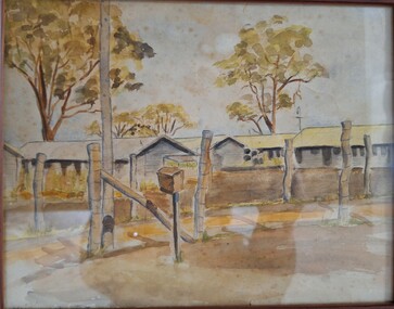
Painting, Watercolour, 1939-1945
Harry Gorry bid for & purchased on internet auction site. The seller's mother was putting these & other items up for auction. Her father/ the seller's grandfather was Dr. Bruno Koening, a German surgeon detained by Allied forces while fleeing New Guinea in 1941. He was detained & sent to be interned in Camp 3, Tatura. There he met the painter Cesare Vagarini & they became friends, thus 4 years later upon the end of the war Vagarini gave the surgeon the two paintings in thanks & in memory of their friendship. Dr Koening then passed the paintings down to his daughter, where they remained in the family for 60 years. The seller's mother decided it was time to sell & was happy that the paintings went to a good home, as the family was until now unaware of the connection between Vagarini and the Tatura Museum. Harry Gorry just happened to notice a familiar name in an auction that he came across by accident & purchased them for our benefit. (Most information copied from Tatura Bulletin article, April 2014).Watercolour painting, depicting barracks at Camp 3. Picture showing fencing posts & bare ground in foreground, and row of huts in background, with 4 trees behind them. at bottom left of picture. writing not legable.tatura, camp 3, vagarini -
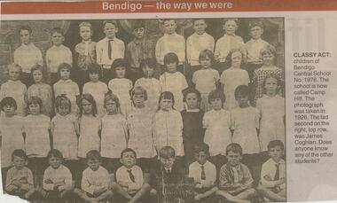 Bendigo Historical Society Inc.
Newspaper - JENNY FOLEY COLLECTION: CLASSY ACT
... Camp Hill Primary School, No.1976, was built on the site...Camp Hill Primary School, No.1976, was built on the site ...Camp Hill Primary School, No.1976, was built on the site of the Police Camp in 1877 and incorporated a fire lookout tower.Bendigo Advertiser ''The way we were'' from Monday, August 5, 2002. Classy act: children of Bendigo Central School No. 1976. The school is now called Camp Hill. The photograph was taken in 1926. The lad second on the right , top row, was James Coghlan. The clip is in a folder.newspaper, bendigo advertiser, the way we were -
 Eltham District Historical Society Inc
Photograph - Digital Photograph, Alan King, Golden King Mine poppet-head, Yarrambat Primary School, 1 February 2008
The Golden King Mine poppet-head stands at the school’s Yan Yean Road exit gate. Published: Nillumbik Now and Then / Marguerite Marshall 2008; photographs Alan King with Marguerite Marshall.; p23 Early Yarambat - Tanck's Corner Its early settlers, who in the 1840s were amongst the first non-Aboriginal people in the area, found life tough as they grazed their sheep and cattle. Yarrambat was then known as Tanck’s Corner or Reynolds Corner, after wood carter, Frederick Tanck, who owned land north of Ironbark Road, at the corner of Yan Yean Road, and Thomas Reynolds, owner of the opposite property. After Reynolds sold his land, the corner became known as Tanck’s Corner. In 1929 the district’s name was changed to Yarrambat, believed to mean ‘high hill’ in the Wurundjeri language. Tanck’s Corner was in the centre of gold-bearing country and the district is honeycombed with old tunnels and shafts. However although gold played a dominant role for decades, there was insufficient to develop a substantial township. Meat and agricultural produce made a greater impact. Until the mid-20th century the only substantial building was the primary school. The first gold rush occurred around 1860, the second after 1900; then during the Depression, the Government paid men to pan for gold. The first rush attracted hundreds of Chinese people to Smugglers Gully, who constructed round diggings to keep away spirits. Alluvial miners lived along the Plenty River in tents or humpies - some fenced with gardens - and some miners distilled their own ‘plonk’. It was a wild time and bushrangers - and later gangster Squizzy Taylor - were said to hide4 in the old Pioneer Tunnel in Dunne’s Gully between Heard Avenue and Pioneer Road. Mines opposite Tanck’s Corner included Beer’s Line, Golden Crown and Golden Stairs. Some of the big mines had batteries and stampers to process quartz. At first there was plenty of alluvial gold, as much as two ounces to the ton. At times gold was exposed after heavy rains so fossickers panned for gold around orchard irrigation trenches. Gold was mined until 1984 when Yarrambat’s last operating goldmine, the Golden King Mine, in North Oatlands Road, closed. The Clayton family operated it full-time, making a comfortable living and in the 1960s it was the only private family gold mine in Victoria.5 Gold was such an important part of Yarrambat’s history that a gold poppet-head is the Yarrambat Primary School’s logo. The Golden King Mine poppet-head stands at the school’s Yan Yean Road exit gate. However this school was built in 1988. The original school No 2054, at the corner of Ironbark and Yan Yean Roads, was opened in 1878 and modified to its present form in the 1920s. In 2000 it was relocated to the Heritage Museum at Yarrambat Park.7 The school, whose first head teacher was Charles Planner, consisted of one room with a three-roomed residence. The school was also the community centre. On Saturday nights it was crammed for dances or euchre parties, community singing or other social events. On Sundays, services for different denominations took turns each week. However the school had its teething problems. Parents accused Charles Planner of neglecting his duties and the school closed several times. When it closed in 1892, only church services continued. Social activities moved elsewhere, such as the tennis club to the Stuchbery tennis court opposite. A sports day and woodchop on Boxing Day around 1900 was held at the Evelyn Hill Hotel, also called Evelyn Arms and Tunnel Hill Hotel, on the Greensborough–Diamond Creek Road. An annual agricultural show in Diamond Creek paraded through the town, and New Year’s Day picnics at the Yan Yean Reservoir included highland dancing and competitions. Also popular were the Indian hawkers who visited every three months, selling trinkets, clothing and other items. One called Jimmy ‘Allem dem Bedi’, gave presents and told stories, played draughts and sold delicious curries he cooked over his camp fire at night.This collection of almost 130 photos about places and people within the Shire of Nillumbik, an urban and rural municipality in Melbourne's north, contributes to an understanding of the history of the Shire. Published in 2008 immediately prior to the Black Saturday bushfires of February 7, 2009, it documents sites that were impacted, and in some cases destroyed by the fires. It includes photographs taken especially for the publication, creating a unique time capsule representing the Shire in the early 21st century. It remains the most recent comprehenesive publication devoted to the Shire's history connecting local residents to the past. nillumbik now and then (marshall-king) collection, golden king mine, tanck's corner, yarrambat primary school -
 Eltham District Historical Society Inc
Photograph - Digital Photograph, Alan King, Maroondah Aqueduct Siphon Bridge over the Plenty River, 26 January 2008
Opened in 1891, the bridge formed part of the Maroondah Aqueduct carrying water from Watts River near Healesville to the reservoir at Preston where it joined Melbourne's metropolitan water system. Covered under Heritage Overlay, Nillumbik Planning Scheme. Published: Nillumbik Now and Then / Marguerite Marshall 2008; photographs Alan King with Marguerite Marshall.; p99 Built to supply thirsty Melbourne in the late 19th century, the siphon bridge spanning the Plenty River off Leischa Court, Greensborough, was part of an engineering masterpiece. Opened in 1891, the bridge formed part of the Maroondah Aqueduct carrying water from the Watts River near Healesville to the reservoir at Preston where it joined the metropolitan distribution system. A major link in Melbourne’s water supply, it also had a huge impact on communities, which mushroomed along its route. Named after the Aboriginal word for the area around the Maroondah Reservoir, the Maroondah Aqueduct was fully operational until the 1970s. Since the 1980s the land along parts of the aqueduct have been used for walking and bicycle riding, shaded in places by Monterey Pine trees planted to stabilise the surrounding ground. From 1857 the Yan Yean Reservoir supplied Melbourne’s water but the growing city needed additional catchments.1 In 1886 work began on a weir on the Watts River to enable the aqueduct to carry most of the river water 41 miles (66km) to Melbourne. The aqueduct, built by the Board of Works, is the oldest remaining aqueduct near Melbourne and was probably the first built with concrete.2 Although the aqueduct is now only used between the Maroondah and Sugarloaf Reservoirs, it can still be traced across the Shire. It extends from the Maroondah Reservoir through Christmas Hills, Kangaroo Ground, Research, Eltham, St Helena and then previously wound west through Greensborough to Reservoir.3 Built by horse and manpower the aqueduct gravity fed 25 million gallons (113.6ML) of water a day to Melbourne along a gradient of one foot to the mile. It included 25 miles (41km) of open concrete and brick channel, six miles (10km) of tunnels, and nine miles (15km) of 14 inverted siphons of riveted wrought-iron across creeks. Bricks for the aqueduct were made from clay found near the sites and remains of several kilns can still be found between Kangaroo Ground and Christmas Hills. Building the aqueduct transformed local communities. An abattoir was established at Christmas Hills. Grog shanties and labourers’ camps sprang up and local courts dealt with cases of ‘petty pilfering and boisterous behaviour’.4 The Kangaroo Ground school population jumped to 91, crammed into a room with one teacher. Miners who built the tunnels camped just north of Churinga in Greensborough – then called Tunnel Hill Camp – and adjacent to the Evelyn Arms Hotel. The miners’ high spirits were sometimes quenched in horse troughs or by a ‘welt under the ear and kick on the behind’ as the local constable calmed them down rather than lock them up.5 But the growing city of Melbourne needed more water, so the O’Shannassy catchment, east of Warburton, was added to the system in 1914. In 1920 work began on the present concrete Maroondah Dam one mile (1.6km) from the weir on the Watts River. The aqueduct capacity was thus doubled to 50 million gallons (227ML) a day.6 Intense land development threatened to pollute the open water supply, so channel sections were replaced with large pipes. In the late 1960s a large water main was built from the tunnel outlet at Research and extended through St Helena and Greensborough, so this section of the aqueduct was taken out of use. Long sections of the unused open channels in Greensborough and Bundoora were destroyed, but the old channel in Research and Eltham North remained largely intact. In the 1970s, the Sugarloaf Reservoir was constructed, inundating 445 hectares of land in Christmas Hills. Sugarloaf was officially opened in 1980 and serves as a water storage and treatment plant supplying Melbourne. In the early 1980s pipes replaced the section from Sugarloaf Reservoir to the tunnel entrance at Kangaroo Ground. The Research-Kangaroo Ground tunnel operates as part of the pipeline system.This collection of almost 130 photos about places and people within the Shire of Nillumbik, an urban and rural municipality in Melbourne's north, contributes to an understanding of the history of the Shire. Published in 2008 immediately prior to the Black Saturday bushfires of February 7, 2009, it documents sites that were impacted, and in some cases destroyed by the fires. It includes photographs taken especially for the publication, creating a unique time capsule representing the Shire in the early 21st century. It remains the most recent comprehenesive publication devoted to the Shire's history connecting local residents to the past. nillumbik now and then (marshall-king) collection, maroondah aqueduct, pipe bridge, siphon bridge -
 Eltham District Historical Society Inc
Photograph - Digital Photograph, Marguerite Marshall, 'Landscape', 60 Lavender Park Road, Eltham South, 24 June 2008
Built by artist and cartoonist Percy Leason in 1927 in what was then New Street but renamed Lavender Park Road in the late 1950s/early 1960s. Covered under Heritage Overlay, Nillumbik Planning Scheme. Published: Nillumbik Now and Then / Marguerite Marshall 2008; photographs Alan King with Marguerite Marshall.; p121 Said to be a genius, cartoonist Percy Leason’s career was at its peak when in 1925 to 1926 he built his home at New Street (now Lavender Park Road) Eltham. The Herald newspaper owner, Sir Keith Murdoch, had hired Leason for his newly acquired Melbourne Punch magazine at a salary of £1750, making him ‘one of the highest paid cartoonists in the world’.1 With this salary and financial help from Murdoch, Leason was able to build his lovely home in Eltham. At the crest of a sweeping drive, the home now two-storey in white brick with a gabled grey slate roof and dormer windows is flanked by an extension built by another owner in the 1980s. Leason lived in the home with his wife, Isabel and children, until 1937, when he left for the United States of America, where he lived until his death in 1959. The four-bedroom house and garden would have been well-suited to bringing up his family and to entertaining their friends in style. Large airy rooms have high ceilings with moulded plaster, timber floors and several are brightened with bay windows. Leason made friends with many of the artists and personalities who gravitated to Eltham. Around 1931 Justus Jörgensen, founder of the Montsalvat Artists’ Colony, helped Leason build his large studio at the back of the house. Another friend was journalist Mervyn Skipper, father of jeweller and sculptor Matcham, and artists Helen and Sonia. Leason’s teacher, artist Max Meldrum, also visited and rented accommodation in Eltham, opposite Wingrove Park. Punch folded in 1925, but Leason continued as cartoonist for Table Talk. In 1926 Leason began the cartoons of a mythical Australian town Wiregrass, which were inspired by Kaniva, his home town. The art gallery in Main Road Eltham was named Wiregrass in Leason’s honour. Leason completed 1000 drawings from 1919 to 1937, which author Garrie Hutchinson claimed, were technically unsurpassed and had regional and universal interest. Leason’s acute observations of country life stemmed from his childhood in Kaniva in Victoria’s western Wimmera, where he was born, the son of a selector, in 1889. Meldrum claimed that Leason could name every plant and the habits of every animal.2 Leason also painted 28 portraits of the last full-blooded aboriginals in Victoria at Lake Tyers in Gippsland, most of which are in a private collection. In Sydney Leason illustrated Henry Lawson’s Selected Poems and worked for The Bulletin. Leason had begun his career at 13 as an apprentice lithographic artist at Sands and MacDougall. He attended night classes at the National Gallery and the Victorian Artists Society. Leason first visited Eltham in 1910 to paint with fellow artist William ‘Jock’ Frater. They camped near Bible and Pitt Streets and along the Diamond Creek on the site of the present Eltham Retirement Centre. Despite his success as a cartoonist, Leason wanted to be recognised as a serious painter and for his anthropological work.3 He was also conservative and felt uncomfortable with the modern art scene in Melbourne.4 So he left for the United States of America to work as a painter. Ironically his time in New York saw the burgeoning of modern art, notably by artists such as Jackson Pollock. But Leason found his niche by running an art school, painting society portraits and illustrating books and magazines.This collection of almost 130 photos about places and people within the Shire of Nillumbik, an urban and rural municipality in Melbourne's north, contributes to an understanding of the history of the Shire. Published in 2008 immediately prior to the Black Saturday bushfires of February 7, 2009, it documents sites that were impacted, and in some cases destroyed by the fires. It includes photographs taken especially for the publication, creating a unique time capsule representing the Shire in the early 21st century. It remains the most recent comprehenesive publication devoted to the Shire's history connecting local residents to the past. nillumbik now and then (marshall-king) collection, landscape, lavender park road, percy leason, new street -
 Eltham District Historical Society Inc
Photograph - Digital Photograph, Marguerite Marshall, Jelbart home, 93 Arthur Street, Eltham, 11 November 2006
Situated at the top of the hill in Arthur Street, the former Jelbart residence and barn were part of a major change that transformed Eltham's character in the late 1960s. Built from the mid 1940s through mid 1950s when Eltham was a rural community, the Jelbrat residence and barn are all that remain of a family property of some 250 acres (100 ha). With growing population pressures, in the late 1960s, owners Ron and Yvonne Jelbart decided to subdivide their property creating the Woodridge Estate in the early 1970s, a major factor towards the transformation of Eltham to the suburb it is today. The Jelbarts had moved to Eltham in the early 1940s when they purchased a poultry farm in New Street, now Lavendar Park Road. (The local Black Friday bushire of January 13, 1939 had started at C.A. (Clarrie) Hurst’s Eltham Poultry Farm and Hatchery in New Street.) Jelbart was primarily a businessman importing office machinery but desired farm beef and dairy cattle so the couple purchased the virgin bushland at what was then at the end of a dirt road, Arthur Street. With post war shortages of most building materials, they followed the example of the Eltham Artists' Colony (later called Montsalvat) and built thier home from mud-bricks and recyclked materials. The barn was first to be completed in 1945 which they made their home whilst building the main residence. It took eight years to complete the two buildings. Both the main residence and the barn are now separate homes, and along with the remaining property being sub-divided further in 1998 are now part of the Kinloch Gardens Estate at 93 Arthur Street. Covered under Heritage Overlay, Nillumbik Planning Scheme. Published: Nillumbik Now and Then / Marguerite Marshall 2008; photographs Alan King with Marguerite Marshall.; p139 Standing on a hilltop at Arthur Street, Eltham, the Jelbart residence and former barn were part of a major change that transformed Eltham’s character in the late 1960s. Built from the late 1940s to the mid 1950s when Eltham was a rural community, they are all that remain of what was once a family property of around 250 acres (100 ha). As population pressure increased in the late 1960s, owners Ron and Yvonne Jelbart, decided to subdivide their property. The break-up of this property into the Woodridge Estate in the early 1970s, was a major factor towards transforming Eltham into the suburb it is today.1 Although standing only a few minutes from Eltham’s busy hub and hundreds of houses in Woodridge, scarcely any urban sound disturbs the peace. Views from the two buildings are almost exclusively of trees and extend to Mt. Dandenong to the south-east, the Great Divide to the north, and Melbourne city to the south-west. The Jelbarts had lived in Eltham since the early 1940s when they bought a poultry farm in New Street, now Lavender Park Road. Although Jelbart was primarily a businessman importing office machinery, he was keen to farm dairy and beef cattle, so the couple bought rough bushland at what was then the end of Arthur Street. But a shortage of building materials following World War Two hampered their plans to build their new home, so they followed the example of the Eltham Artists’ Colony (later called Montsalvat) and used mud-bricks and recycled materials.2 With great determination the family and friends constructed their house. Massive timber frames and huge quantities of mud-bricks were made on site. The barn was built first in 1945, and two years later, while camping inside, the Jelbarts started building their house. It took eight years to construct the two buildings, even with the help of professional tradesmen. The buildings, with timber frames infilled with mud-brick and plastered, are reminiscent of the English Tudor style. The Jelbarts are of Cornish stock. Much of the timber framework came from demolished bridges or warehouses, and recycled slate was used for roofs and floors. Quality second-hand materials were readily available in the late 1940s and 1950s when there was much demolition in Melbourne and little respect for heritage. A former 19th century Toorak mansion Woorigoleen provided the magnificent stone fireplace, the timber panelling and the parquetry floor in the living room. The large stone gateposts at the entry of the property came from Melbourne University. Almost no mechanical equipment was used to build the 55 square house and the 25 square barn. Massive timber frames were erected using block and tackle pulleys and timbers were shaped, sawn and drilled by hand. Son and architect Ian, with his family, have lived in and extensively renovated both buildings since the early 1970s. Ian transformed the steep ridge of the property into a plateau, where the main house Kinloch stands, surrounded by terraces and lawns. The grounds retain many native plants, including massive yellow boxes – some nudging 80 years. Ian attached 70 metres of pergolas draped with wisteria, roses and grape vines, to three sides of the house. The beautiful garden is featured in the book Through the Rose Arbour by Rosemary Houseman. The two-storey barn – now a house – retains traces of its original use. The cow-shed with milking and feed-rooms, and the machinery-shed remain. The house, separated on the ground floor by a breeze-way, soars two storeys and includes a mezzanine. These are connected by spiral staircases, to timber-beamed and plaster-lined high-pitched ceilings. The house also descends to a wine cellar. Curiously the roof is of corrugated iron on the south and slate on the north, to save costs. Small-paned windows and three French doors open onto the front lawn, which extends to Jelbart Court.This collection of almost 130 photos about places and people within the Shire of Nillumbik, an urban and rural municipality in Melbourne's north, contributes to an understanding of the history of the Shire. Published in 2008 immediately prior to the Black Saturday bushfires of February 7, 2009, it documents sites that were impacted, and in some cases destroyed by the fires. It includes photographs taken especially for the publication, creating a unique time capsule representing the Shire in the early 21st century. It remains the most recent comprehenesive publication devoted to the Shire's history connecting local residents to the past. nillumbik now and then (marshall-king) collection, eltham, arthur street, jelbart barn, jelbart home, kinloch gardens -
 Eltham District Historical Society Inc
Photograph - Digital Photograph, Alan King, St Andrews Hotel, 2 February 2008
The c1860 St Andrews Hotel, with the c1930 additions, and the Canary Island Palm, and the surrounding site to the title boundaries are historically, socially and aesthetically significant to the Shire of Nillumbik. The St Andrews Hotel is historically significant because it may have given its name 'St Andrews' to the town (another suggestion is that the name came from St Andrews church) and for its connection to Ewen Hugh Cameron (1831-1915) the prosperous local farmer, member of the Eltham Roads Board/Shire Council and local MP. It is also significant as the oldest hotel building in the former Shire of Eltham, as one of the few surviving buildings connected with the Caledonian goldfields era and as one of a handful of early structures to have survived the 1960s bushfires; the additions and alterations to the hotel reflect its long life. The hotel is socially significant because it has served as an important meeting place for more than 160 years. The Canary Island Palm is historically significant as a rare example of exotic tree planting in this rural area. The tree is aesthetically and historically significant as a local landmark and for its contribution to the streetscape and landscape value. Covered under Heritage Overlay, Nillumbik Planning Scheme. Published: Nillumbik Now and Then / Marguerite Marshall 2008; photographs Alan King with Marguerite Marshall.; p71 Built around 1860, St Andrews Hotel has changed little since it first welcomed thirsty gold diggers from the Caledonia Goldfields. The timber building, with gabled roof, beamed ceilings and a massive fireplace, is Nillumbik Shire’s oldest hotel and has always been an important community centre, particularly in its early days. Fortunately, the hotel and the near-by Canary Island Palm Tree, which is quite rare in this area, survived the 1960s bushfires, along with a few other early buildings. St Andrews (formerly Queenstown) was founded on gold, as were Panton Hill (formerly Kingstown), Research and Diamond Creek, from the mid-1850s to the 1860s. But by the early 20th century common use changed the name Queenstown to St Andrews, possibly after this hotel or after the church or the mining district.1 The Caledonia Diggings were probably named by Scottish settlers after the Roman name for Scotland, despite this land bearing little similarity to their homeland.2 Queenstown, which was proclaimed as a township in 1861, was the gold-mining centre on the Upper Diamond and in the 1850s had up to 600 European inhabitants and a small camp of Chinese on the flats along the creek. Queenstown was the administrative centre of the Upper Diamond with three hotels, a brewery and a slaughterhouse.3 It is unclear which hotel was the district’s first, as distinct from the earliest unlicensed grog shops, some of which operated in tents. John Corke Knell was one of eight unlicensed storekeepers supplying drink to miners at Caledonia in 1857, named by Sgt. McNamara of the Caledonia Police Station.4 In February 1859, Knell apparently bought most of the present hotel’s site at the first township land sales. As he was a local storekeeper, he might have first established a store there.5 Knell and his wife Eliza were early licensees of the St Andrews Hotel. The hotel had eight bedrooms – including three for public use – and the dining-room seated 30 people. It is thought they named the hotel St Andrews after Eliza’s hometown of St Andrews in Scotland. St Andrews Hotel was an important local centre in several ways. In the same building the Knells also operated a post office and general store. In 1867 Mrs Knell was appointed Deputy Registrar of Births and Deaths for Queenstown. The hotel was also used to hold inquests into people’s deaths when the police residence became too small.6 The hotel also became a fashionable destination at Christmas for parties from Melbourne. In 1868, possibly following her husband’s death, Mrs Knell applied for a temporary licence, which was then transferred to Robert Smith after their marriage in 1869. But then, possibly after Robert’s death, Mrs Smith operated the hotel until 1892. This contradicts a report in The Evelyn Observer 1882 that JC Knells of the St Andrews Hotel was granted a publican’s licence in the Queenstown Police Court. At that time he was supposed to have been dead for around 14 years! Although Mrs Smith was a respected citizen, known for her geniality and as an ideal hostess, she had a minor brush with the law when she was fined ten shillings for not lighting a lamp outside her licensed premises.7 From 1892 several publicans owned the hotel including W Atkins, from 1895. In 1909 the licensee was apparently Mrs Smith’s son, Walter Knell, who held the licence until at least the 1920s. Not surprisingly, this old hotel has attracted romantic stories. Mrs Smith is said to be seen roaming the pub in her nightdress – even though she was buried in the Queenstown Cemetery in 1911.8 A musical The Hero of Queenstown, set in the hotel, was written and produced by local actor Reg Evans in the 1970s.This collection of almost 130 photos about places and people within the Shire of Nillumbik, an urban and rural municipality in Melbourne's north, contributes to an understanding of the history of the Shire. Published in 2008 immediately prior to the Black Saturday bushfires of February 7, 2009, it documents sites that were impacted, and in some cases destroyed by the fires. It includes photographs taken especially for the publication, creating a unique time capsule representing the Shire in the early 21st century. It remains the most recent comprehenesive publication devoted to the Shire's history connecting local residents to the past. nillumbik now and then (marshall-king) collection, st andrews hotel -
Merbein District Historical Society
Journal - Quarterly, Merbein Historian - Quarterly Journal of MDHS - No 43 (2 copies), Mar.2011
mark (cr) eckel., bernadette wells, a self drive tour of historic sites - buildings - places of interest, hazel dowsley, merbein higher elementary school staff 1958, mavis mary bennett, jack bennett, ray slade, joan (nee goetz) dodds, easter camp memories 1952 - 1956, shirley lake (racquets), merbein dairy, dora's diaries, joyce bosenberg (letter) , merbein cheer up club, barbara downing, richard neeman, dorothy nice, laurel nice, vi nice, phillip day, arthur mcmahon, douglas hore, richard appleby, percy appleby, appleby vintage equipment, samuel brindsen, jack treen, albert hunt, elwood mead, merbein common -
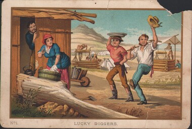 Bendigo Historical Society Inc.
Postcard - WES HARRY COLLECTION: LUCKY DIGGERS
... U1526-U1535. POSTCARD mine site Diggers Mining camp A colour ...From a set of ten plates, the plates are: 1. Lucky diggers -- 2. Clearing the forest -- 3. Spearing emus -- 4. The stockrider -- 5. The vineyard -- 6. A pannikin of gold -- 7. Throwing the boomerang -- 8. Opossum hunting -- 9. Washing tailings -- 10. Teamsters' rest. The prints are numbered 1-10 and individually titled. Also available online http://nla.gov.au/nla.obj-139535117 U1526-U1535.A colour or coloured print of some lucky diggers dancing in the street with some smiling onlookers. In the background there are some tents and two windlasses. On the bottom left of the card is printed No. 1, indicating that this is one of a series. postcard, mine site, diggers, mining camp -
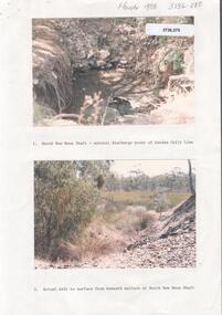 Bendigo Historical Society Inc.
Photograph - Kangaroo Flat Gold Mine Collection: Deadhorse Gully, Sydney Flat Creek March 1986
Colour photographs, seventeen images on nine page. Images labelled as follows : 1. North New Moon shaft - natural discharge point of Garden Gullly line 2. Actual exit to surface from beneath mullock at North New Moon shaft. 3. Looking into Deadhorse Gully from mullock heap at North New Moon site. 4. Deadhorse Gully downstream of WMC Weir. 5. Sydney Creek track crossing - impassable ford. 6. Sydney Creek looking downstream from ford. 7. Sydney Creek looking upstream from road near Recreation Reserve (12 inch pipe under road). 8. Sydney Creek looking downstream from same point. 9. Sydney Creek - Camp Road, looking upstream.. 10. Sydney Creek - Camp Road, looking downstream. 11. Sydney Creek - Camp Road Culverts. 12. Sydney Creek - Pyramid Road Bridge, looking upstream. 13. Sydney Creek - Pyramid Road Crossing looking downsteam. 14. Sydney Creek - rail crossing, looking upstream. 15. Sydney Creek - rail crossing, looking downstream. 16. Sydney Creek - Airstrip road, looking upstream. 17. Sydney Creek - Airstrip Road, looking downstream 12 inch pipe under road. Lined paper, in blue pen 'Deadhorse Gully-Sydney Flat Creek, March 1986, Photos of Deadhorse Gully/Sydney Flat Creek'kangaroo flat gold mine, deadhorse gully, sydney flat creek, unity mining, water discharge, north new moon, camp road, pyramid hill road, eaglehawk -
![Plan, Improvements on the Camp Reserve Ballarat, 1870, 26/4/1870 (exact); Traced by Henry [Mornes?], district surveyor, on the above date](/media/collectors/4f729f6797f83e0308601707/items/4f72a4fa97f83e0308602508/item-media/59b79d3921ea680200c6b8a7/item-fit-380x285.jpg) Federation University Historical Collection
Federation University Historical CollectionPlan, Improvements on the Camp Reserve Ballarat, 1870, 26/4/1870 (exact); Traced by Henry [Mornes?], district surveyor, on the above date
The Ballarat Camp housed the Goldfields administrators. It was from this site that the troopers left on the morning of 3 December 1854 to attack the Eureka Stockade. Much of the area shown in on the west side of Camp Street is now used by the Federation University Arts Academy.Hand-drawn plan on white linen showing the camp reserve in what is now known Ballarat's Camp Street. The plan shows allotments in an area bounded by Mair, Sturt and Lydiard Streets. The plan has colours indicating wooden buildings, stone buildings, brick buildings, Wood & zinc buildings, and wood & brick buildings.ballarat, camp street, horace walker, henry mornes, goldfields architecture, reserve for public, buildings, goldfields administration, eureka stockade -
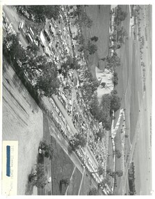 Bendigo Historical Society Inc.
Photograph - ELMORE FIELD DAYS 1970
Elmore Field Days were first held in 1964.Black and white aerial photograph of Elmore Field Days site. Lines of exhibitors and vehicles on site. Anabranch of Campaspe River alongside site. On back of photo :' Robert Wallace Studios, 8 Ruth Street, Golden Square' Elmore Field Days site has been moved to purpose built site nearbye. The site pictured is now a camping reserve.event, agriculture, elmore field days -
Bendigo Historical Society Inc.
Photograph - ELMORE FIELD DAYS
... , an anabranch of the Campaspe River. Site is now a camping reserve... site. Undated but possibly 1969-1970. Image shows exhibitor ...Elmore Field Days were first held in 1964.Aerial photograph of Elmore Field Days site. Undated but possibly 1969-1970. Image shows exhibitor stands, roadways and parked vehicles. Oh LH side of image is a water course, an anabranch of the Campaspe River. Site is now a camping reserve as the Elmore Field Days is now (2022) held at a nearby site.event, agriculture, elmore field days -
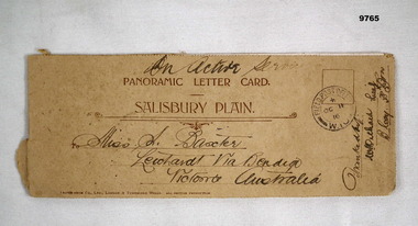 Bendigo Military Museum
Card - PANORAMIC LETTER CARD, Hotocrom Co. Ltd, c.1916
Sent home by Capt. Frederick Baxter MC. Part of the Baxter Collection. Refer Cat No.4219.Cream colour panoramic card Salisbury Plain. Inside 4 pages with 8 images of Army Barracks or tourist sites. On front is address sent to in Australia, Post Office stamp and signed off by Battalion. Photos are all labelled as per inscription and held together by one staple.Photo's labelled. Top written "On Active Service". 1. 40857 Bulford Camp. 2. 48060 Bulford Camp B Lines. 3. 36891 Bulford Camp near Salisbury. 4. 36868 Salisbury Plain, Tidworth Barracks. 5. 36889 Bulford The Bridge. 6. Amesbury, Queensbury Bridge. 7. 32482 Salisbury Stonehenge. 8. 32478 Salisbury Cathedral.letter card, baxter collection, ww1, baxter mc -
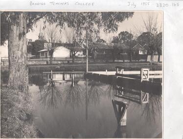 Bendigo Historical Society Inc.
Photograph - LA TROBE UNIVERSITY BENDIGO COLLECTION: BENDIGO TEACHERS' COLLEGE
... photograph photographs site place municipal baths Camp Hill State ...A black and white photograph of Bendigo Teachers' College in July 1955. The photograph was taken by Mr. A.G. Davey or Mr. Tailor. The Municipal Baths are in the foreground and the Lookout Tower can be seen on the right hand side. On the right of the buildings which housed Rooms 3,4,5 and 6 is the brick building Room 2. In the background is the Camp Hill spire. Reflections of the trees and wooden constructions can be seen in the water. A vanguard car is parked in the school car park. See 3320.100bendigo, education, bendigo teachers' college, la trobe university bendigo collection, collection, bendigo, education, tertiary education, teacher training, bendigo teachers' college, photo, photos, photograph, photographs, site, place, municipal baths, camp hill state school, lookout tower, history, miss j.c. burnett, mr. geoff pryor -
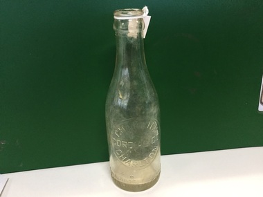 Charlton Golden Grains Museum Inc
Container - Charlton Cordial Co. Glass Bottle, Charlton Cordial Company, Circa late 19th Century
The bottle represents the cordial making industry that existed in Charlton during the late 1800's, early 1900's. We are unsure of the site of the factory, but the local iceworks existed into the 1960's. It was located on the corner of Camp and Armstrong Streets. This is important because it represents an industry that existed in Charlton many years ago. It would have been an early form of today's soft drink.Clear glass bottle. With an embossed label reading "Charlton Cordial Co. Charlton'Charlton Cordial Co This bottle always remains the property of Cordial Company of Charlton. F 1335glass bottle, cordial bottle, charlton, business, industry -
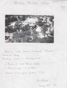 Bendigo Historical Society Inc.
Photograph - LA TROBE UNIVERSITY BENDIGO COLLECTION: BENDIGO TEACHERS' COLLECTION
A black and white photograph of an arial view of Bendigo Teachers' College from the Lookout Tower in Rosalind Park in the 1950's. Room 2 is the old Police stable and there are two aluminium pre-fabs. The other rooms are 3 and 4 and 5 and 6. The Bendigo jail is in the background. On the far right is the Camp Hill State School. 1950's. See 3320.100bendigo, education, bendigo teachers' college history, la trobe university bendigo collection, collection, bendigo, tertiary education, teacher training, education, photo, photos, photograph, photographs, lookout tower, rosalind park, bendigo jail, bendigo gaol, jail, gaol, police stable, camp hill state school, history, building, buildings, site, place, bendigo teachers' college -
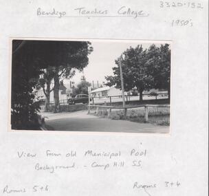 Bendigo Historical Society Inc.
Photograph - LA TROBE UNIVERSITY BENDIGO COLLECTION: BENDIGO TEACHERS' COLLEGE
A black and white photograph of Bendigo Teachers' College rooms 3 and 4 and 5 and 6. Taken from the old Municipal Pool in the 1950's. In the background is the Camp Hill State School. See 3320.100bendigo, education, bendigo teachers' college, la trobe university bendigo collection, collection, bendigo, education, bendigo teachers' college, teacher training, tertiary education, photo, photos, photograph, photographs, bendigo municipal pool, municipal pool, swimming pool, camp hill state school, place, site, building, buildings, history -
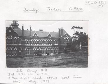 Bendigo Historical Society Inc.
Photograph - LA TROBE UNIVERSITY BENDIGO COLLECTION: CAMP HILL STATE SCHOOL
(a) A black and white photograph of Camp Hill State School the third site of Bendigo Teachers' College. The top right hand rooms were used from 1945 to house the college until May, 1959. (b) A Bendigo 'Advertiser' photo of the Central State School situated in Rosalind Park, Bendigo. See 3320.100bendigo, education, camp hill state school, la trobe university bendigo collection, collection, bendigo, education, tertiary education, teacher training, photo, photos, photograph, photographs, photography, state school, primary school, bendigo teachers' college, central state school, camp hill state school, rosalind park, ms. j.c. burnett, mr. geoff pryor, newspaper, advertiser, place, building -
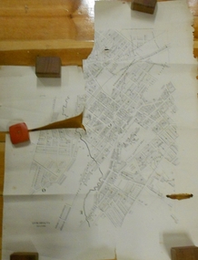 Bendigo Historical Society Inc.
Document - MARKS COLLECTION: PLAN OF SANDHURST CITY CENTRE AND SURROUNDING AREA ( NO. 1 )
Plan on heavy parchment - section neatly cut out of area now Kennington. Written on plan in black print ' Sheet No. 1. Sandhurst'. Plan shows Government Camp, Commissioner's Gully, old cemetery site, manure depot, cattle market, Benevolent Asylum Reserve, railway reserve. Landowners' names on allotments. On bottom lithographed at the Department of Lands and Survey, Melbourne, by D. Henerson, March 12th., 1867 Plan part of George Lansell, Fortuna auction, documents found in wardrobe purchased by Marks family in 1930's.bendigo, planning, sandhurst 1867 -
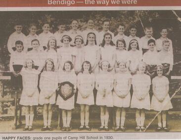 Bendigo Historical Society Inc.
Newspaper - JENNY FOLEY COLLECTION: HAPPY FACES
... Camp Hill Primary School, No.1976, was built on the site...Camp Hill Primary School, No.1976, was built on the site ...Camp Hill Primary School, No.1976, was built on the site of the Police Camp in 1877 and incorporated a fire lookout tower.Bendigo Advertiser ''The way we were'' from Monday, April 22, 2002. Happy faces: grade one pupils of Camp Hill school in 1930. The clip is in a folder.newspaper, bendigo advertiser, the way we were -
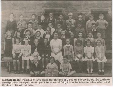 Bendigo Historical Society Inc.
Newspaper - JENNY FOLEY COLLECTION: SCHOOL DAYS
... Camp Hill Primary School, No.1976, was built on the site...Camp Hill Primary School, No.1976, was built on the site ...Camp Hill Primary School, No.1976, was built on the site of the Police Camp in 1877 and incorporated a fire lookout tower.Bendigo Advertiser ''The way we were'' from 2003. School days: the class of 1946, grade four students at Camp Hill Primary School. The clip is in a folder.newspaper, bendigo advertiser, the way we were