Showing 1594 items
matching e. s.
-
 Warrnambool and District Historical Society Inc.
Book, The Uncounted Cost by Mary Gaunt, 1925
The Uncounted Cost is one of a number of works written by Mary Gaunt. Her other works include, Alone in West Africa, A Woman in China, The End of the Earth, Kirkhams Find, The Moving Finger and Deadman’s. Mary was born at Indigo near Chiltern in 1862 and lived for many years in Ballarat where her father W.H. Gaunt was gold commissioner and later a judge. The original Gaunt family home was converted into St Patrick’s College. She married Dr Lindsay Miller and moved to Warrnambool and after his death in 1899 she embarked on her travels which took her to many parts of the world. She died in Cannes, France in January 1942.Mary Gaunt wrote over 25 novels, numerous travel books and many stories and articles. She had a strong link with Warrnambool and details of the district are included among her writings. She also wrote regularly in the early 1900’s for the Times in London on women issues. She was an independent thinker and worker. Blue hard cover with illustration in dark blue depicting one person sitting looking upwards to another person holding spear. 248 pages. Clementine E Coles written in black pen inside front cover. Dedication: To my friend Agnes Herbert. the uncounted cost, mary gaunt, alone in west africa, warrnambool -
 Kiewa Valley Historical Society
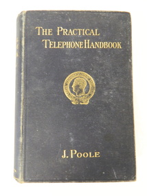
Book - Technical on Telephones / Switchboards, The Practical Telephone Handbook by J. Poole, 1912
This book includes "Guide to the Telephone Exchange". As the State Electricity Commission of Victoria had a telephone exchange on the Kiewa Hydro Electric Scheme at Mt Beauty, this book is of interest. The first telephone exchange was established in the U.S.A. in 1877. In 1912 most civilised countries had one. Improvements continued as outlined in the book explaining how they work.The State Electricity Commission of Victoria constructed the Kiewa Hydro Electric Scheme and communicated using a switchboard based in Mt Beauty. This book belonged Roy F. Leibig, the grandfather of a local electrician.Black hard cover book with gold embossing of title, author and emblem "The Specialists Series" on the front cover. 630 pages with some black and white diagramsInside: "W. Kerr Newmann / 89 Moreland Grove / Coburg" written in pencil "S. Dunkerton / 8 Horne St / E. Brunswick / Oct. 7th 1913" crossed out with pencil (over handwriting with pen) "R.F. Leibig / "Orama" / Stafford St / West Preston" written in inkinstructional book; technical; telephones; switchboards; telephone exchange; state electricity commission of victoria -
 Kiewa Valley Historical Society
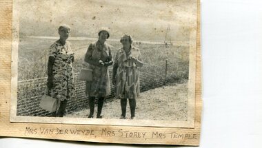
Photographs x 2- Groups of Kiewa Valley residents on tour of Khancoban area
Demonstrates a pictorial history of social activities undertaken by Kiewa Valley residents during this period possibly 1970’s to 1980’s. Also a pictorial record of residents of the Kiewa Valley during this period. Photographs demonstrate local Kiewa Valley residents enjoying a community visit to the Khancoban area, which holds significance to the early history of the district. Its heritage is celebrated in Banjo Paterson’s epic poem, “The Man from Snowy River”. 2 black and white photographs mounted on buff card. 1. Group of ladies on a tour of the Khancoban area 2. Mixed group of ladies and men on a tour of the Khancoban area 1. Handwritten in black ink below photo 'Mrs Van Der Weyde, Mrs Storey, Mrs Temple 2. Handwritten in black pen below photo 'A.O. Smith, A. Angus, Mrs. Pullin, S. Ross, C. Roper, Mrs Temple, A. E. Campbell (name of last person obscured)kiewa valley residents, clare roper -
 Kiewa Valley Historical Society
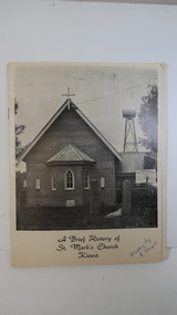
Booklet - St Mark's Church Kiewa x2, A Brief History of St Mark's Church Kiewa written by E. Temple
The Anglican Church at Kiewa. The first stone was laid on the 29th Oct. 1924. In 1879, the Yackandandah rector commenced services on Sundays in private homes in the Kiewa Valley. In 1911 Anglicans met in the Kiewa Methodist Church to elect a committee to organise financial offers and so it eventually became a vestry.The town Kiewa is in the Kiewa Valley. The church served other communities in the Valley. The book records the local populations and their commitment to religion. Cream cardboard cover with a black and white photo of the church on the front cover. It has 4 pages printed on both sides held by 2 staples. Inside there are a few black and white photos. Dated 19741. "Written by E. Temple" handwritten on the front cover 2. "C. Roper" on the front cover and inside the front cover "Clare Roper" Also, "Esther Temple" 's signature on the cover page.st mark's church, kiewa, anglican church, esther teple, thomas mitchell -
 Kiewa Valley Historical Society
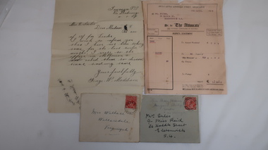
Letters x4 - Re Mrs Stiles
The Advocate was the Catholic newspaper of Victoria. The correspondence is in regard to payment and receipt of the newspapers.4 letters, 2 with envelopes. Chronological order: 1. 11 Jan 1927. From George W. Maddison, Tawonga P. O. Via Dederang to Mrs E. Stiles re money for 'Leader'. 2. 5th Apr. 1928. From Melbourne to Mrs Stiles, Melbourne re Account or "Advocate' 3. late July 1928. From Miss Mary Hessian, Mongans Bridge. Via Wodonga to Mrs Stiles re 'advocate' 4. 28th Jan. 1929 From Chas Martin to Mrs Wallace Bonnie Brae, Bruarong re Mrs Stiles papers. Envelopes: 1. (letter 3)Mrs Stiles c/- Miss Reid 26 Hoddle St. Elsternwick S-4 and in pencil Miss Mary Hessian, Mongan's Bridge, Huon via Wodonga 2. (letter 4) Mrs Wallace, Wallacedale, Kergunyah.mrs e. stiles, mary hessian, george w. maddison, mr wallace, 'advocate' newspaper, chas martin -
 Warrnambool and District Historical Society Inc.
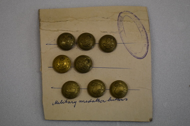
Buttons, Australian Military Buttons, Early 20th Century
The Australian Military Forces buttons were worn by Australian troops in World Wars One and Two. The Australian Commonwealth buttons date from the Edwardian era (1901-1910)These buttons are examples of the buttons used by the Australian Army. The attachment to a card is also an interesting example of the way members of the Warrnambool and District Historical Society mounted and displayed collection items in the 1960's and 1970's.Seven brass circular military buttons pressed into a rectangular piece of cardboard with pasted on lined paper on the back of the cardboard. Three of the buttons feature a raised map of Australia, a crown and text. Five buttons feature a raised intertwined E R,V11, a crown and text Protruding through the paper at the back is a section of a ring. The cardboard side has hand drawn blue lines, an oval stamp with text and hand written text. Three buttons have AUSTRALIAN MILITARY FORCES. Five buttons have AUSTRALIAN COMMONWEALTH FORCES Military medallion buttons ( hand written) Stamp is oval shaped with faded text of which only HISTORICAL DISTRICT and SOCIETY can be deciphered Three blue hand drawn lines to position the buttons. army, australian military forces, buttons, world war two, world war one -
 Eltham District Historical Society Inc
Photograph - Aerial Photograph, Landata, Eltham / Research, Vic, Jan. 1951
... : 1419 GDA2020 : 37°42'32"S, 145°10'41"E MGA2020 : 339408... : 1419 GDA2020 : 37°42'32"S, 145°10'41"E MGA2020 : 339408 ...Centred on Brinkkotter Road opposite Yarramie Reserve, Eltham bounded by Maroondah Aqueduct to north, Nyora Road to south, Eltham College to east and Leane Drive to west. Historic Aerial Imagery Source: Landata.vic.gov.au Aerial Photo Details: Project No :65 Project : MELBOURNE AND METROPOLITAN PROJECT NO. 2 Run : 7 Frame : 8 Date : 01/1951 Film Type : B/W Camera : EAG9 Flying Height : 12200 Scale : 12000 Film Number : 1419 GDA2020 : 37°42'32"S, 145°10'41"E MGA2020 : 339408, 5824924 (55) Melways : 22 F3 (ed. 42)Historical aerial photos and photo maps provide viusal evidence of the chronology of changes to the built landscape of the district and assist in dating other imagesaerial photo, 1951-01, eltham, neil webster collection, brinkkotter road, eltham college, leane drive, maroondah aqueduct, melways 22f3, nyora road, yarramie reserve -
 Eltham District Historical Society Inc
Photograph - Aerial Photograph, Landata, Eltham, Vic, Jan. 1951
... : 1419 GDA2020 : 37°42'23"S, 145°09'39"E MGA2020 : 337874... : 1419 GDA2020 : 37°42'23"S, 145°09'39"E MGA2020 : 337874 ...Centred on Beard Street between Main Road and Frank Street, Eltham bounded by Maroondah Aqueduct to north, Arthur Street to south, Maroong Drive to east and Catholic Ladies College to west. Historic Aerial Imagery Source: Landata.vic.gov.au Aerial Photo Details: Project No :65 Project : MELBOURNE AND METROPOLITAN PROJECT NO. 2 Run : 7 Frame : 9 Date : 01/1951 Film Type : B/W Camera : EAG9 Flying Height : 12200 Scale : 12000 Film Number : 1419 GDA2020 : 37°42'23"S, 145°09'39"E MGA2020 : 337874, 5825170 (55) Melways : 22 B3 (ed. 42)Historical aerial photos and photo maps provide viusal evidence of the chronology of changes to the built landscape of the district and assist in dating other imagesaerial photo, 1951-01, eltham, neil webster collection, arthur street, beard street, catholic ladies college, frank street, main road, maroondah aqueduct, maroong drive, melway 22b3, research (vic.) -
 Eltham District Historical Society Inc
Photograph - Aerial Photograph, Landata, Eltham, Vic, Jan. 1951
... Film Number : 1419 GDA2020 : 37°42'14"S, 145°08'36"E MGA2020... Film Number : 1419 GDA2020 : 37°42'14"S, 145°08'36"E MGA2020 ...Centred on Allison Crecent Reserve, Sherbrook Road and Scenic Crescent, Eltham bounded by Allendale Road to north, Dudley Street to south, Zig Zag Road to east and St Helena Road to west. Historic Aerial Imagery Source: Landata.vic.gov.au Aerial Photo Details: Project No :65 Project : MELBOURNE AND METROPOLITAN PROJECT NO. 2 Run : 7 Frame : 10 Date : 01/1951 Film Type : B/W Camera : EAG9 Flying Height : 12200 Scale : 12000 Film Number : 1419 GDA2020 : 37°42'14"S, 145°08'36"E MGA2020 : 336339, 5825416 (55) Melways : 21 H2 (ed. 42)Historical aerial photos and photo maps provide viusal evidence of the chronology of changes to the built landscape of the district and assist in dating other imagesaerial photo, 1951-01, eltham, neil webster collection, allendale road, allison crecent reserve, dudley street, melway 21h2, scenic crescent, sherbrook road, st helena road, zig zag road -
 Eltham District Historical Society Inc
Photograph - Aerial Photograph, Landata, Eltham North, Feb. 1956
... °42'16"S, 145°08'08"E MGA2020 : 335650, 5825336 (55) Melways : 21...°42'16"S, 145°08'08"E MGA2020 : 335650, 5825336 (55) Melways : 21 ...Centred on present day 54 Kelway Crescent, Eltham North bounded by Glen Gully Road to north, Meruka Drive to south, Eltham College to east and Leach Street to west. Historic Aerial Imagery Source: Landata.vic.gov.au Aerial Photo Details: Project No :250 Project : MELBOURNE OUTER SUBURBS PROJECT Run : 17 Frame : 113 Date : 02/1956 Film Type : B/W Camera : EAG9 Flying Height : 10000 Scale : 12000 Film Number : 1176 GDA2020 : 37°42'16"S, 145°08'08"E MGA2020 : 335650, 5825336 (55) Melways : 21 G2 (ed. 42)aerial photo, 1956-02, eltham, eltham north, glen gully road, leach street, main road, melway 21g2, meruka drive, montmorency, neil webster collection -
 Eltham District Historical Society Inc
Photograph - Aerial Photograph, Landata, Montmorency, Feb. 1956
... GDA2020 : 37°42'50"S, 145°08'02"E MGA2020 : 335512, 5824286 (55... GDA2020 : 37°42'50"S, 145°08'02"E MGA2020 : 335512, 5824286 (55 ...Centred on present day Tahlee Place Reserve and Sherbourne Preschool, Montmorency bounded by Progress Road to north, Withers Way to south, Main Road to east and Leach Street to west. Historic Aerial Imagery Source: Landata.vic.gov.au Aerial Photo Details: Project No :250 Project : MELBOURNE OUTER SUBURBS PROJECT Run : 17 Frame : 114 Date : 02/1956 Film Type : B/W Camera : EAG9 Flying Height : 10000 Scale : 12000 Film Number : 1176 GDA2020 : 37°42'50"S, 145°08'02"E MGA2020 : 335512, 5824286 (55) Melways : 21 F5 (ed. 42)aerial photo, 1956-02, neil webster collection, central park, eltham, leach street, main road, melway 21f5, montmorency, progress road, withers way, sherbourne preschool, tahlee place reserve -
 Eltham District Historical Society Inc
Photograph - Aerial Photograph, Landata, Montmorency, Feb. 1956
... Film Number : 1176 GDA2020 : 37°43'24"S, 145°07'55"E MGA2020... Film Number : 1176 GDA2020 : 37°43'24"S, 145°07'55"E MGA2020 ...Centred on present day Grand Boulevard and Olympic Way, Montmorency bounded by Diamond Street to north, Old Eltham Road and Eltham Lower Park to south, Bible Street to east and Para Road to west. Historic Aerial Imagery Source: Landata.vic.gov.au Aerial Photo Details: Project No :250 Project : MELBOURNE OUTER SUBURBS PROJECT Run : 17 Frame : 115 Date : 02/1956 Film Type : B/W Camera : EAG9 Flying Height : 10000 Scale : 12000 Film Number : 1176 GDA2020 : 37°43'24"S, 145°07'55"E MGA2020 : 335375, 5823236 (55) Melways : 21 F7 (ed. 42)aerial photo, 1956-02, neil webster collection, eltham, main road, montmorency, bible street, diamond street, eltham lower park, grand boulevard, melway 21f7, old eltham road, olympic way, para road -
 Eltham District Historical Society Inc
Photograph - Aerial Photograph, Landata, Lower Plenty, Feb. 1956
... : 12000 Film Number : 1176 GDA2020 : 37°43'58"S, 145°07'49"E... : 12000 Film Number : 1176 GDA2020 : 37°43'58"S, 145°07'49"E ...Centred on present day 217 Old Eltham Road, Lower Plenty bounded by Pitt Street to north, Yarra River to south, Main Road to east and Bonds Road to west. Historic Aerial Imagery Source: Landata.vic.gov.au Aerial Photo Details: Project No :250 Project : MELBOURNE OUTER SUBURBS PROJECT Run : 17 Frame : 116 Date : 02/1956 Film Type : B/W Camera : EAG9 Flying Height : 10000 Scale : 12000 Film Number : 1176 GDA2020 : 37°43'58"S, 145°07'49"E MGA2020 : 335237, 5822186 (55) Melways : 21 E10 (ed. 42)aerial photo, 1956-02, neil webster collection, eltham, main road, bonds road, elham, lower plenty, melway 21e10, pitt street, yarra river -
 Eltham District Historical Society Inc
Photograph - Aerial Photograph, Landata, Eltham, Feb. 1956
... GDA2020 : 37°43'35"S, 145°09'31"E MGA2020 : 337735, 5822959 (55... GDA2020 : 37°43'35"S, 145°09'31"E MGA2020 : 337735, 5822959 (55 ...Centred on present day Culla Hill and Petty's Orchard, Eltham bounded by Brougham Street and Mount Pleasant Road to north, Monckton Road, Templestowe to south, Reynolds Road to east and Eltham Lower Park and Hohnes Road to west. Historic Aerial Imagery Source: Landata.vic.gov.au Aerial Photo Details: Project No :250 Project : MELBOURNE OUTER SUBURBS PROJECT Run : 18 Frame : 92 Date : 02/1956 Film Type : B/W Camera : EAG9 Flying Height : 10000 Scale : 12000 Film Number : 1176 GDA2020 : 37°43'35"S, 145°09'31"E MGA2020 : 337735, 5822959 (55) Melways : 22 B8 (ed. 42)aerial photo, 1956-02, neil webster collection, eltham, brougham steet, culla hill, eltham lower park, hohnes road, melway 22b8, monckton road, mount pleasant road, petty's orchard, reynolds road, sweeneys lane, templestowe, yarra river -
 Eltham District Historical Society Inc
Photograph - Aerial Photograph, Landata, Eltham, Feb. 1956
... GDA2020 : 37°43'02"S, 145°09'38"E MGA2020 : 337871, 5823961 (55... GDA2020 : 37°43'02"S, 145°09'38"E MGA2020 : 337871, 5823961 (55 ...Centred on present day Mount Plaeasant Road near Dalton Street, Eltham bounded by Luck Street to north, Eltham Lower Park to south, Reynolds Road to east and Central Park to west Historic Aerial Imagery Source: Landata.vic.gov.au Aerial Photo Details: Project No :250 Project : MELBOURNE OUTER SUBURBS PROJECT Run : 18 Frame : 93 Date : 02/1956 Film Type : B/W Camera : EAG9 Flying Height : 10000 Scale : 12000 Film Number : 1176 GDA2020 : 37°43'02"S, 145°09'38"E MGA2020 : 337871, 5823961 (55) Melways : 22 B6 (ed. 42)aerial photo, 1956-02, neil webster collection, eltham, central park, eltham lower park, luck street, melway 22b6, nyora road, reynolds road, dalton street, mount pleasant road -
 Eltham District Historical Society Inc
Photograph - Aerial Photograph, Landata, Eltham, Feb. 1956
... GDA2020 : 37°41'57"S, 145°09'51"E MGA2020 : 338145, 5825965 (55... GDA2020 : 37°41'57"S, 145°09'51"E MGA2020 : 338145, 5825965 (55 ...Centred on present day Shalbury Avenue, Eltham bounded by Leane Drive and Parsons Road to north, Nyora Road to south, Reynolds Road to east and the Diamond Creek to west Historic Aerial Imagery Source: Landata.vic.gov.au Aerial Photo Details: Project No :250 Project : MELBOURNE OUTER SUBURBS PROJECT Run : 18 Frame : 95 Date : 02/1956 Film Type : B/W Camera : EAG9 Flying Height : 10000 Scale : 12000 Film Number : 1176 GDA2020 : 37°41'57"S, 145°09'51"E MGA2020 : 338145, 5825965 (55) Melways : 22 C1 (ed. 42)aerial photo, 1956-02, neil webster collection, eltham, diamond creek (creek), melway 22c1, nyora road, parsons road, reynolds road, shalbury avenue -
 Eltham District Historical Society Inc
Photograph - Aerial Photograph, Landata, Eltham, Vic, Feb. 1956
... Film Number : 1176 GDA2020 : 37°42'04"S, 145°11'09"E MGA2020... Film Number : 1176 GDA2020 : 37°42'04"S, 145°11'09"E MGA2020 ...Centred on present day Parsons Avenue at Leane Drive near the Maroondah Aqueduct, Eltham bounded by Lorimer Road to north, Thompson Crescent and Norman Road to south, Bells Hill Road to east and Parsons Road to west Historic Aerial Imagery Source: Landata.vic.gov.au Aerial Photo Details: Project No :250 Project : MELBOURNE OUTER SUBURBS PROJECT Run : 19 Frame : 5 Date : 02/1956 Film Type : B/W Camera : EAG9 Flying Height : 10000 Scale : 12000 Film Number : 1176 GDA2020 : 37°42'04"S, 145°11'09"E MGA2020 : 340064, 5825786 (55) Melways : 22 H1 (ed. 42)aerial photo, 1956-02, neil webster collection, allendale road, bells hill road, eltham, leane drive, lorimer road, maroondah aqueduct, melway 22h1, norman road, parsons road, research (vic.), thompson crescent -
 Eltham District Historical Society Inc
Photograph - Aerial Photograph, Landata, Research, Vic, Feb. 1956
... GDA2020 : 37°42'38"S, 145°11'02"E MGA2020 : 339927, 5824736 (55... GDA2020 : 37°42'38"S, 145°11'02"E MGA2020 : 339927, 5824736 (55 ...Centred on present day Thompson Crescent, Research bounded by Maroondah Aqueduct to north, Thompson Crescent and Nyora Road to south, Bells Hill Road to east and Eucalyptus Road to west Historic Aerial Imagery Source: Landata.vic.gov.au Aerial Photo Details: Project No :250 Project : MELBOURNE OUTER SUBURBS PROJECT Run : 19 Frame : 6 Date : 02/1956 Film Type : B/W Camera : EAG9 Flying Height : 10000 Scale : 12000 Film Number : 1176 GDA2020 : 37°42'38"S, 145°11'02"E MGA2020 : 339927, 5824736 (55) Melways : 22 H4 (ed. 42)aerial photo, 1956-02, neil webster collection, bells hill road, eltham, eucalyptus road, maroondah aqueduct, melway 22h4, nyora road, research (vic.), thompson crescent -
 Eltham District Historical Society Inc
Photograph - Aerial Photograph, Landata, Eltham, Vic, Apr. 1963
... Number : 1805 GDA2020 : 37°42'24"S, 145°08'52"E MGA2020 : 336716... Number : 1805 GDA2020 : 37°42'24"S, 145°08'52"E MGA2020 : 336716 ...Centred on present day Zig Zag Road and Main Road, Eltham bounded by Maroondah Aqueduct to north, Thompson Crescent and Arthur Street to south, Parsons Road to east and Glen Park Road and Banks Road to west. Historic Aerial Imagery Source: Landata.vic.gov.au Aerial Photo Details: Project No :486 Project : MELBOURNE (1963) PROJECT Run : 5 Frame : 59 Date : 04/1963 Film Type : B/W Camera : RC8 Flying Height : 5100 Scale : 9600 Film Number : 1805 GDA2020 : 37°42'24"S, 145°08'52"E MGA2020 : 336716, 5825114 (55) Melways : 21 J3 (ed. 42)aerial photo, neil webster collection, eltham, 1963-04, arthur street, banks road, glen park road, maroondah aqueduct, melway 21j3, parsons road -
 Eltham District Historical Society Inc
Photograph - Aerial Photograph, Landata, Eltham, Vic, Apr. 1963
... Number : 1805 GDA2020 : 37°42'24"S, 145°09'29"E MGA2020 : 337622... Number : 1805 GDA2020 : 37°42'24"S, 145°09'29"E MGA2020 : 337622 ...Centred on present day Floriston Grove, Eltham bounded by Maroondah Aqueduct to north, Thompson Crescent and Diosma Road to south, Research Shops to east and Glen Park Road and Park West Road to west. Historic Aerial Imagery Source: Landata.vic.gov.au Aerial Photo Details: Project No :486 Project : MELBOURNE (1963) PROJECT Run : 5 Frame : 60 Date : 04/1963 Film Type : B/W Camera : RC8 Flying Height : 5100 Scale : 9600 Film Number : 1805 GDA2020 : 37°42'24"S, 145°09'29"E MGA2020 : 337622, 5825128 (55) Melways : 22 B3 (ed. 42)aerial photo, neil webster collection, eltham, 1963-04, diosma road, floriston grove, maroondah aqueduct, melway 22b3, park west road, research (vic.), research shops -
 Eltham District Historical Society Inc
Photograph - Aerial Photograph, Landata, Research, Vic, Apr. 1963
... : 1805 GDA2020 : 37°42'24"S, 145°10'06"E MGA2020 : 338528... : 1805 GDA2020 : 37°42'24"S, 145°10'06"E MGA2020 : 338528 ...Centred on present day Thompson Crescent and Nicholson Close, Research bounded by Maroondah Aqueduct to north, Nyora Road to south, Eltham College to east and Eltham Gateway Hotel to west. Historic Aerial Imagery Source: Landata.vic.gov.au Aerial Photo Details: Project No :486 Project : MELBOURNE (1963) PROJECT Run : 5 Frame : 61 Date : 04/1963 Film Type : B/W Camera : RC8 Flying Height : 5100 Scale : 9600 Film Number : 1805 GDA2020 : 37°42'24"S, 145°10'06"E MGA2020 : 338528, 5825143 (55) Melways : 22 D3 (ed. 42)aerial photo, neil webster collection, eltham, 1963-04, eltham college, eltham gateway hotel and conference centre, maroondah aqueduct, melway 22d3, nicholson close, nyora road, research (vic.), thompson crescent -
 Eltham District Historical Society Inc
Photograph - Aerial Photograph, Landata, Research, Vic, Apr. 1963
... : 5100 Scale : 9600 Film Number : 1805 GDA2020 : 37°42'24"S... : 5100 Scale : 9600 Film Number : 1805 GDA2020 : 37°42'24"S ...Centred on present day Marconi Court, Research bounded by Maroondah Aqueduct to north, Thompson Crescent to south, Joselyn Drive to east and Eltham Research Oval to west. Historic Aerial Imagery Source: Landata.vic.gov.au Aerial Photo Details: Project No :486 Project : MELBOURNE (1963) PROJECT Run : 5 Frame : 62 Date : 04/1963 Film Type : B/W Camera : RC8 Flying Height : 5100 Scale : 9600 Film Number : 1805 GDA2020 : 37°42'24"S, 145°10'43"E MGA2020 : 339434, 5825157 (55) Melways : 22 F3 (ed. 42)aerial photo, neil webster collection, 1963-04, joselyn drive, marconi court, melway 22f3, research (vic.), research oval, thompson crescent -
 Eltham District Historical Society Inc
Photograph - Aerial Photograph, Landata, Eltham, Vic, Apr. 1963
... °43'12"S, 145°08'54"E MGA2020 : 336800, 5823623 (55) Melways : 21...°43'12"S, 145°08'54"E MGA2020 : 336800, 5823623 (55) Melways : 21 ...Centred on present day John Street, Eltham between Main and Bible streets bounded by Elsa Court to north, Main Road Bridge to south, Wattle Grove to east and Bolton Street to west. Historic Aerial Imagery Source: Landata.vic.gov.au Aerial Photo Details: Project No :486 Project : MELBOURNE (1963) PROJECT Run : 6 Frame : 123 Date : 04/1963 Film Type : B/W Camera : RC8 Flying Height : 5100 Scale : 9600 Film Number : 1805 GDA2020 : 37°43'12"S, 145°08'54"E MGA2020 : 336800, 5823623 (55) Melways : 21 J6 (ed. 42)aerial photo, neil webster collection, 1963-04, bolton steet, elsa court, eltham, john street, main road, main road bridge, melway 21j6, wattle grove -
 Eltham District Historical Society Inc
Photograph - Aerial Photograph, Landata, Eltham, Vic, Apr. 1963
... °43'12"S, 145°08'16"E MGA2020 : 335876, 5823604 (55) Melways : 21...°43'12"S, 145°08'16"E MGA2020 : 335876, 5823604 (55) Melways : 21 ...Centred on present day Eltham Ridge, Bolton Street, Eltham bounded by Elsa Court to north, Main Road to south, Bible Street to east and Reichelt Avenue and Rattray Road to west. Historic Aerial Imagery Source: Landata.vic.gov.au Aerial Photo Details: Project No :486 Project : MELBOURNE (1963) PROJECT Run : 6 Frame : 124 Date : 04/1963 Film Type : B/W Camera : RC8 Flying Height : 5100 Scale : 9600 Film Number : 1805 GDA2020 : 37°43'12"S, 145°08'16"E MGA2020 : 335876, 5823604 (55) Melways : 21 G6 (ed. 42)aerial photo, neil webster collection, 1963-04, bible street, bolton street, eltham, eltham ridge, main road, montmorency, rattray road, reichelt avenue -
 Eltham District Historical Society Inc
Photograph - Aerial Photograph, Landata, Lower Plenty, Vic, Apr. 1963
... Number : 1805 GDA2020 : 37°44'03"S, 145°07'56"E MGA2020 : 335420... Number : 1805 GDA2020 : 37°44'03"S, 145°07'56"E MGA2020 : 335420 ...Centred on present day Old Eltham Road near Araluen Centre, Lower Plenty bounded by Cromwell Street to north, Yarra River to south, Main Road at Mount Pleasant Road to east and Panorama Avenue to west. Historic Aerial Imagery Source: Landata.vic.gov.au Aerial Photo Details: Project No :486 Project : MELBOURNE (1963) PROJECT Run : 7 Frame : 231 Date : 04/1963 Film Type : B/W Camera : RC8 Flying Height : 5100 Scale : 9600 Film Number : 1805 GDA2020 : 37°44'03"S, 145°07'56"E MGA2020 : 335420, 5822027 (55) Melways : 21 F10 (ed. 42)aerial photo, neil webster collection, 1963-04, araluen, cromwell street, eltham, lower plenty, main road, melway 21f10, mount pleasant road, old eltham road, panorama avenue, yarra river -
 Eltham District Historical Society Inc
Photograph - Aerial Photograph, Landata, Eltham, Vic, Apr. 1963
... : 1805 GDA2020 : 37°44'03"S, 145°08'33"E MGA2020 : 336329... : 1805 GDA2020 : 37°44'03"S, 145°08'33"E MGA2020 : 336329 ...Centred on present day Eltham Lower Park bounded by Brougham Street to north, Yarra River and Fitzsimons Lane Bridge to south, Main Road at Kent Hughes Road to east and Bolton Street to west. Historic Aerial Imagery Source: Landata.vic.gov.au Aerial Photo Details: Project No :486 Project : MELBOURNE (1963) PROJECT Run : 7 Frame : 232 Date : 04/1963 Film Type : B/W Camera : RC8 Flying Height : 5100 Scale : 9600 Film Number : 1805 GDA2020 : 37°44'03"S, 145°08'33"E MGA2020 : 336329, 5822040 (55) Melways : 21 H10 (ed. 42)aerial photo, neil webster collection, 1963-04, bolton steet, brougham steet, eltham, eltham lower park, fitzsimons lane bridge, kent hughes road, melway 21h10, yarra river -
 Eltham District Historical Society Inc
Photograph - Aerial Photograph, Landata, Eltham, Vic, Apr. 1963
... : 1805 GDA2020 : 37°44'04"S, 145°09'10"E MGA2020 : 337237... : 1805 GDA2020 : 37°44'04"S, 145°09'10"E MGA2020 : 337237 ...Centred on present day Griffith Park Road, Eltham bounded by Mount Pleasant Road to north, Yarra River and Templestowe to south, Main Road at Reynolds Road to east and Falkiner Street to west. Historic Aerial Imagery Source: Landata.vic.gov.au Aerial Photo Details: Project No :486 Project : MELBOURNE (1963) PROJECT Run : 7 Frame : 233 Date : 04/1963 Film Type : B/W Camera : RC8 Flying Height : 5100 Scale : 9600 Film Number : 1805 GDA2020 : 37°44'04"S, 145°09'10"E MGA2020 : 337237, 5822053 (55) Melways : 22 A10 (ed. 42)aerial photo, neil webster collection, 1963-04, eltham, falkiner street, griffith park road, melway 22a10, mount pleasant road, reynolds road, templestowe, yarra river -
 Eltham District Historical Society Inc
Photograph - Aerial Photograph, Landata, Eltham North, Vic, Apr. 1972
... : 2636 GDA2020 : 37°41'52"S, 145°08'52"E MGA2020 : 336705... : 2636 GDA2020 : 37°41'52"S, 145°08'52"E MGA2020 : 336705 ...Centred on present day Eltham North reserve near Eltham North Primary School, Eltham North bounded by Allendale Road to north, Bellevue Road to south, Zig Zag Road and Beard Street to east and Ryans Road to west. Historic Aerial Imagery Source: Landata.vic.gov.au Aerial Photo Details: Project No :985 Project : MELBOURNE 1972 Run : 26 Frame : 190 Date : 04/1972 Film Type : B/W Camera : RC10 Flying Height : 5700 Scale : 9600 Film Number : 2636 GDA2020 : 37°41'52"S, 145°08'52"E MGA2020 : 336705, 5826102 (55) Melways : 11 J12 (ed. 42)aerial photo, neil webster collection, 1972-04, allendale road, beard street, bellevue road, eltham, eltham north, eltham north reserve, melway 11j12, ryans road, zig zag road, eltham north primary school -
 Eltham District Historical Society Inc
Photograph - Aerial Photograph, Landata, Eltham, Vic, Apr. 1972
... : 5700 Scale : 9600 Film Number : 2636 GDA2020 : 37°41'56"S... : 5700 Scale : 9600 Film Number : 2636 GDA2020 : 37°41'56"S ...Centred on present day Zig Zag Road near Coolabah Drive, Eltham bounded by Allendale Road to north, Park West Road to south, Parsons Road to east and Banks Road to west. Historic Aerial Imagery Source: Landata.vic.gov.au Aerial Photo Details: Project No :985 Project : MELBOURNE 1972 Run : 26 Frame : 191 Date : 04/1972 Film Type : B/W Camera : RC10 Flying Height : 5700 Scale : 9600 Film Number : 2636 GDA2020 : 37°41'56"S, 145°09'26"E MGA2020 : 337533, 5826000 (55) Melways : 22 A1 (ed. 42)aerial photo, neil webster collection, 1972-04, allendale road, eltham, eltham north, zig zag road, banks road, coolabah drive, melway 22a1, park west road, parsons road -
 Eltham District Historical Society Inc
Photograph - Aerial Photograph, Landata, Eltham, Vic, Apr. 1972
... Scale : 9600 Film Number : 2636 GDA2020 : 37°42'00"S, 145... Scale : 9600 Film Number : 2636 GDA2020 : 37°42'00"S, 145 ...Centred on present day Parsons Road, Eltham bounded by Allendale Road to north, Frank Street to south, Research Shops and Raglan Road to east and Zig Zag Road to west. Historic Aerial Imagery Source: Landata.vic.gov.au Aerial Photo Details: Project No :985 Project : MELBOURNE 1972 Run : 26 Frame : 192 Date : 04/1972 Film Type : B/W Camera : RC10 Flying Height : 5700 Scale : 9600 Film Number : 2636 GDA2020 : 37°42'00"S, 145°09'59"E MGA2020 : 338360, 5825897 (55) Melways : 22 D1 (ed. 42)aerial photo, neil webster collection, 1972-04, allendale road, eltham, zig zag road, frank street, melway 22d1, parsons road, raglan road, research (vic.), research shops, eltham barrel