Showing 488 items
matching material properties
-
 Whitehorse Historical Society Inc.
Photograph, Bundoora Park Homestead
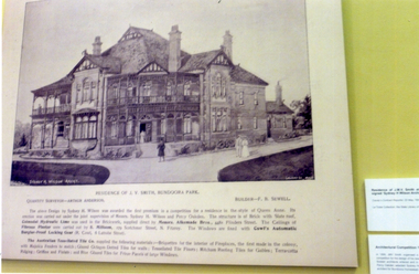
In 1899 John Vincent Smith acquired the property known as 'Bundoora Park'. In the same year he organised a public competition for a design for a house to be built on the property. The competition (worth $50) was won by architect Sydney Herbert Wilson who also designed the Malvern Town Hall. In 1990 a fourteen room mansion was erected. The Australia Tesselated Tile Co of Mitcham supplied most of the tiles for the walls and floors, and Griffins and Lilials for the roof decoration.Coloured photograph detailing the history of Bundoora Park Homestead, Bundoora. Features a drawing of the mansion. The Australian Tesselated Tile Co. Pty Ltd of Mitcham supplied tiles and other materials.bundoora park homestead, australian tesselated tile co pty ltd, tiles -
 Ballarat and District Irish Association
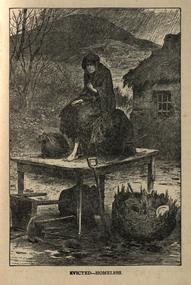
Image, Evicted - Homeless, 1864, c1864
Absentee landlords were common in Ireland and for many landlords the primary focus was income rather than the conditions of their tenants. Many landlords realized that they could get a higher income by turning their properties to pasture than to continue with the old practice of collecting rents from tenant farmers. Evictions was the most common way of getting rid of unwanted tenants. The tenant frequently built his cottage himself from local materials. However, his rent was higher if he had windows, if his door was over a certain height and if he made any type of improvements or enlargements to the dwelling. The landlords practiced "Rack Renting" in order to get rid of unwanted tenants. Rents were raised to the point that the tenant could not afford to pay them. The landlord then had the tenant evicted for non payment of rent. There were no appeals and no mercy shown. Although the only legal reason for eviction was non payment of the rent there were numerous examples of landlords who evicted tenants if they did not conform to the landlord's wishes.[http://www.maggieblanck.com/Mayopages/Eviction.html, accessed 13/12/2013] This image was also printed in he Illustrated London News, April 17, 1886, with the title 'all that is left, scene at a Mayo Eviction. A barefoot woman sits on a table in the rain, outside a cottage with thatched roof. She is surrounded by her possessions.ballarat irish, eviction, rent, cottage, tenant, homeless, mayo -
 Southern Sherbrooke Historical Society Inc.
Information folder - Sophie Jago Giles
Grey plastic A4 display folder of material pertaining to Sophie Jago Giles. Contents: -2 colour photos of Giles house in Belgrave South -short biography (2 copies) by Helen Gibson, inc. brief details of Giles family and establishing of Belgrave South State School -article dated 10 Jun 1970 re. Miss Giles' death -photocopy of photo of men clearing school block, 1922 -typescript, re. house and property, compiled by S. Heywood-Downard from information given by Sid Stocks et al., 2005sophie jago giles, giles family, belgrave south state school -
 Melbourne Legacy
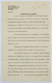
Letter, Re Balnarring Camp Property, c.1930
Referring to the legal history and transfer of land for the Junior Legacy Club Balnarring camp from Legatee Savige. Melbourne Legacy provided camps for junior legatees - the children of deceased servicemen. It started with outings to the property of Legacy founder, Legatee Stan Savige, who had a place in Balnarring. Permanent camp buildings were built in 1930. Lord Somers (Governor of Victoria) also ran a camp in the area and the area became known as Somers. These documents record the transfer of the land to Legacy. The camps gave the children an opportunity of a summer beach holiday with other Legacy children.An important record of the history of the land owned by Stan Savige that was used for Legacy Camp, it adds to the other material available about Legacy Camp at Somers.White foolscap paper with black typed x 5 pages. Single sided. Black type with red corrections and some grey lead remarks. Addressed to ‘The chairman,/ Junior Legacy Club,/ 55 Market Street,/ Melbourne. C.1. From ‘Yrs Faithfully/ sgd/ J.H. Armstrong and W. A. Tregent. See also collection item 00253. somers camp, properties, land transfer -
 Ballarat Tramway Museum
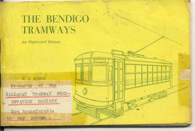
Book, Keith Kings, "The Bendigo Tramways", Feb. 1972
Yields information about the history of Bendigo Tramways and has a strong association with the closure of the system in 1972 and the author.An illustrated History of the Bendigo Tramways. 80 pages, gloss art paper, in black ink with a yellow card cover in green ink, saddle bound. Details history of Bendigo tramways, its tramcars and the involvement of the various operators. Has maps and photographs. Has been covered with a plastic covering material with a typed note "Property of the Ballarat Tramway Preservation Society, Not transferable to any person" underlined in red ink and position underneath the plastic covering. See also Reg item 326 for other copies of this book and scans of the map pages.Notes on pages 2, 14, 35, 38, 42, 44, 48, 49, 51 - 55, 57, 58, 61 - 65, 70, 73, 76 and 79 - in pencil under the photograph captions,trams, tramways, bendigo, history -
 Bendigo Historical Society Inc.
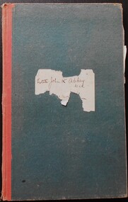
Legal record - Frederick Douglas Jones collection: Estate Book John K Abbey dec'd
1. John Knox Abbey (1863 - 27/7/1938) was originally a landowner in Rochester. He married Ethel May Winch in 1897 and their children were all born in Rochester. Sometime after 1918 he inherited the "Cluny" estate in Penola, SA., from his uncle William MacPherson. He died and was buried in a private graveyard on this property. 2. Also mentioned in the estate papers is G. (Gertrude) Alice Jones. Miss Jones was one of the first females to be admitted to the bar (1912) and was the first female to appear before the court in Bendigo. Her father was local solicitor F.D.JonesLegal journal - green linen covers with red material binding, poor condition, stapled spine. Handwritten notes on assets and amounts in black and red ink. Contains listings of the assets of John Knox Abbey dec'd. Date of death unknown, Probate issued 30/09/1938 for estate of £8719 4s 5d. Inserted legal notes and calculations. First page entry details Executrices/ Trustees of John Knox Abbey as Ethel M Abbey "Clurry" Penola South Australia, and G. Alice Jones 135 Myrtle Street Bendigo Vic. john knox abbey, f d jones -
 Kew Historical Society Inc
Plan - Subdivision Plan, Kewdene Estate, 1937-1939
Pru Sanderson, in her groundbreaking ‘City of Kew Urban Conservation Study : Volume 2 - Development History’ (1988), summarised the periods of urban development and subdivisions of land in Kew. The periods that she identified included 1845-1880, 1880-1893, 1893-1921, 1921-1933, 1933-1943, and Post-War Development. These periods were selected as they represented periods of rapid growth or decline in urban development. An obvious starting point for Sanderson’s groupings involved population growth and the associated economic cycles. These cycles also highlighted urban expansion onto land that was predominantly rural, although in other cases it represented the decline and breakup of large estates. A number of the plans in the Kew Historical Society’s collection can also be found in other collections, such as those of the State Library of Victoria and the Boroondara Library Service. A number are however unique to the collection.The Kew Historical Society collection includes almost 100 subdivision plans pertaining to suburbs of the City of Melbourne. Most of these are of Kew, Kew East or Studley Park, although a smaller number are plans of Camberwell, Deepdene, Balwyn and Hawthorn. It is believed that the majority of the plans were gifted to the Society by persons connected with the real estate firm - J. R. Mathers & McMillan, 136 Cotham Road, Kew. The Plans in the collection are rarely in pristine form, being working plans on which the agent would write notes and record lots sold and the prices of these. The subdivision plans are historically significant examples of the growth of urban Melbourne from the beginning of the 20th Century up until the 1980s. A number of the plans are double-sided and often include a photograph on the reverse. The advertisement for the ‘Kewdene Estate’ subdivision is pasted over a photograph of a property for sale. This is typical of the reuse of promotional materials in the period during, and subsequent to World War I. The subdivision included 14 lots bordered by Belmore Road, Birtles Street and Giles Street. On the other side of the subdivision [Glass] Creek is noted. The subdivision plan also shows part of the Outer Circle Railway and Deepdene Railway Station.subdivision plans - east kew, kewdene estate, belmore road -- kew east (vic.), giles street -- kew east (vic.) -
 Kew Historical Society Inc
Plan, Melbourne & Metropolitan Board of Works : Borough of Kew : Detail Plan No.1573, 1905
The Melbourne and Metropolitan Board of Works (MMBW) plans were produced from the 1890s to the 1950s. They were crucial to the design and development of Melbourne's sewerage and drainage system. The plans, at a scale of 40 feet to 1 inch (1:480), provide a detailed historical record of Melbourne streetscapes and environmental features. Each plan covers one or two street blocks (roughly six streets), showing details of buildings, including garden layouts and ownership boundaries, and features such as laneways, drains, bridges, parks, municipal boundaries and other prominent landmarks as they existed at the time each plan was produced. (Source: State Library of Victoria)This plan forms part of a large group of MMBW plans and maps that was donated to the Society by the Mr Poulter, City Engineer of the City of Kew in 1989. Within this collection, thirty-five hand-coloured plans, backed with linen, are of statewide significance as they include annotations that provide details of construction materials used in buildings in the first decade of the 20th century as well as additional information about land ownership and usage. The copies in the Public Record Office Victoria and the State Library of Victoria are monochrome versions which do not denote building materials so that the maps in this collection are invaluable and unique tools for researchers and heritage consultants. A number of the plans are not held in the collection of the State Library of Victoria so they have the additional attribute of rarity.Original survey plan, issued by the MMBW to a contractor with responsibility for constructing sewers in the area identified on the plan within the Borough of Kew. The plan was at some stage hand-coloured, possibly by the contractor, but more likely by officers working in the Engineering Department of the Borough and later Town, then City of Kew. The hand-coloured sections of buildings on the plan were used to denote masonry or brick constructions (pink), weatherboard constructions (yellow), and public buildings (grey). This plan has detailed annotations written in red or blue ink, showing prices, which may be the annual valuations of the properties, and some owners’ names, a most unusual feature on contractor's maps. Some areas, such as the buildings of Methodist Ladies’ College (MLC), include the school’s tennis court and swimming pool, but are not coloured to show building materials – did the draftsman just run out of time, or ink, or enthusiasm, before his plan had to be submitted? MLC had been founded in 1882 as a ‘modern school of the first order’ with buildings that formed ‘a collegiate institution for girls unsurpassed in the colonies’. The goal of its founders was to provide a high-class Christian education for girls, comparable with that provided elsewhere for boys. Some shops are shown along Edgevale Road, though they are not designated as commercial premises. Larger houses are depicted, including ‘Fairlawn’ in Barkers Road, and ‘Clevedon’ and ‘Rosehill’ (now demolished) in Fitzwilliam Street.melbourne and metropolitan board of works, detail plans, mmbw 1573, maps - borough of kew, cartography -
 Surrey Hills Historical Society Collection
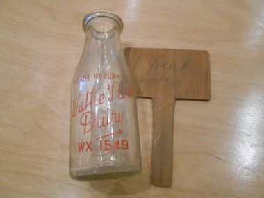
Domestic object - Wooden note, Note for the milk man
This note to the local milkman was associated with the milk bottle from the Wattle Park Dairy, which was purchased by Robin Kelly from a home in Surrey Hills in the 1970's or 1980's. This dairy was established by Horrie Breeden. The Breeden family came to Surrey Hills in 1905, first to Guildford Road, then Middlesex Road where Horrie Breeden lived as a boy. He sometimes used to help with milking at the adjoining Kenneally's dairy in Highfield Road. Sometimes he and his brother drove the cows from there to Schneider's property near Florence Road on the way to Surrey Hills Primary School. The cows would graze here until the boys took them back after school. At other times he would deliver milk from the Croydon Road dairy (Isherwood's or Bovill's) to St Joseph's Boys Home before school. Horrie became an apprentice in woodwork / carpentry at Vine's timber yard before serving in World War 1. Horrie's father died in 1919 and in the same year he bought 3 cows and established his own dairy on his mother's property on the corner of Goodwood Street and Boisdale Road. In the 1920s Horrie built the first house in Goodwood Street. He went on to build others in the street including his own at No 7 Goodwood Street. He did all the joinery and internal fittings for this. [Oral testimony: Horrie Breeden to Jocelyn Hall in 1979.] In the first half of the 20th century there were many local dairies in Surrey Hills and Mont Albert. In those days home deliveries were comparatively informal. This note to the milkman is material evidence of this. A rectangular wooden T-shaped note; the vertical part extending from middle of the lower edge and the upper part wide enough to balance on the top of a milk bottle.In grey lead pencil: " 1 pint / extra"dairies, milk delivery -
 Surrey Hills Historical Society Collection
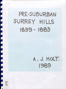
Book, Alan Judge Holt (deceased), Pre-Suburban Surrey Hills 1839-1883, 1989
Author: Alan Judge Holt amassed a significant collection of historical material related to the Surrey Hills area. Born in Moonee Ponds in 1912 to Edmund Holt and Ellen Ruby Sutton, he married Edna Jean Pallot in 1937. They lived at 62 Broughton Road, Surrey hills, had 3 sons and were strongly associated with the Surrey Hills Methodist Church. Alan was Secretary of the Victorian Lands Department and in his spare time recorded the occupancy of every property in Surrey Hills and Mont Albert at the beginning of each decade from 1890 to 1980. His collection of files and individual cards covers people, places, churches, clubs, businesses and other organisations in the area. Alan used this information to give talks and tours of the area and gifted his material to the local history collection through Jocelyn Hall.Unpublished manuscript / notes written by Alan Holt about settlers in and around Surrey Hills bound in-house. It is supported by maps showing landowners over various years from about 1840-1885(mr) henry jamieson, (mr) ken hall, (ms) edna holt, (mr) frank bamford, (mr) harrison buchanan, scouts, grange hill, wattle park, round hill, bona vista, mount albert, barton street, (mr) john raeburn, (mr) edmund holt, (mr) james dunn, butter merchant, mont albert road, elgar road, view hill, new street, surry mont, delany's hill, reservoir hill, riversdale road, middlesex road, surrey hills, (mr) aldo massora, aborigines, damper creek, back creek, west creek, kooyongkoot creek, (mr) john gardiner, (mr) chas mullins, (mr) henry elgar, (mr) robert campbell, (mr) alexander dyce, (mr) robert brooks, t budds payne, (mr) hugh glass, (mr) patrick trainer, w virtue, (mr) t fulton, (mr) john crimp, (mr) w dempsey, (mr) w e stanbridge, (mr) james atkinson, j porter, j collings, w edde, (mr) orlando fenwick, (dr)(mr) l l smith, (mr) j h knipe, (mr) george cockcroft, (sr) (mr) john martin kleinert, w morton, d delaney, a moeller, (mr) william smith, (mr) e.p.s.sturt, (mr) thomas blood, (mr) patrick mornane, (mr) henry de carle, w craig, j hill, w oliver, j keogh, a laing, vineyards, toll gates, (mr) david staig, (mr) phillip kleeper, (mr) goyder usher, (mr) james lawler, (mr) w.e. stanbridge, (mr) gideon rutherford, c a f mater, j gadsby, w h wrixon, e h lamont, i ainger, (mr) james henty, (mr) henry henty, w freemantle, w palmer, beckett park, maranoa gardens -
 Surrey Hills Historical Society Collection
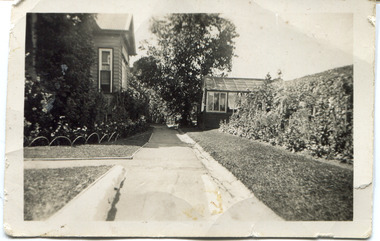
Digital photo, 45 Wandsworth Road, Surrey Hills, 1956
... is material evidence of a property that has been demolished ...According to the donor, the photo was taken before the driveway was constructed. The house was later extended at the rear and was re-roofed. The donor's grandparents Daniel Patrick Liddy and Beatrice Bridget Tyner (known as 'Beat') were married in at her parents' home in Glencoe, South Australia on 13 December 1908. They lived in the Carlton / North Melbourne area before moving to Surrey Hills. Electoral rolls list them at 92 Curtain Street, North Carlton in 1913. According to the donor, they rented several properties before purchasing 45 Wandsworth Road. They are listed at Albert Crescent in 1914 and 1919, but also lived in Zetland Road. They purchased 45 Wandsworth Road in c1923 and are listed in the electoral rolls there in 1924. The donor's mother Ellen Dorothy Liddy (known as Eileen) was born in 1909; her brother Daniel John Liddy was born in 1911, both in Carlton. Daniel Patrick Liddy died in 1955; his wife Beatrice died in 1959. They are buried in Box Hill Cemetery (RC183-0045). 45 Wandsworth Road was their home for over 30 years.This image is material evidence of a property that has been demolished.A black and white photo taken from the street looking up a path or narrow driveway. On the LHS is part of a weatherboard house, Edwardian in style. On the RHS is the boundary fence against which is a garden border separated from the driveway by a section of grass. In the background is a glasshouse.Rear along top edge in blue biro: "Aunty Eileens house / before she was married" - according to the donor, this is his cousin's writing. Aunty Eileen was Ellen Dorothy Liddy who married Hugh Turnbull in 1936. Along LH edge, perhaps in a different hand " 23-10-1956" Photo laboratory processing stamp in black ink " 2 48", stamped twice.wandsworth road, daniel patrick liddy, beatrice bridget tyner, beatrice bridget liddy, ellen dorothy liddy, daniel john liddy, box hill cemetery, gardens -
 Surrey Hills Historical Society Collection
Photograph, Grovedale Road Quarry in the 1920s - looking north, c1920
The quarry was part of John Butler Maling's property. He was one of the original settlers of the area and farmed the area between Weybridge Street and Whitehorse Road. Clay was quarried from part of this area and used to make the bricks used in the construction of his home, known as 'Ancyra'. This is still extant at the corner of Weybridge and James Streets. Maling grazed cows and used the quarry as a water source. He was the uncle of John Butler Maling, Mayor of Camberwell. He was married to Kate Conlon in 1882. They had 3 children: Silas Young, Alick and Zillah. Maling was born in c1829 in Shepreth, Cambridgeshire; he died in Surrey Hills on 9 October 1912 and is buried in Box Hill Cemetery - CE-*-0586. Mrs Kate Maling (born c1859 in Co Meath, Ireland) died at the property on 8 March 1921. She is buried in Brighton General Cemetery. Probate was valued at over 10,000 pounds and included other properties in Sandringham, Hawthorn and Macedon. At the time of her death the Surrey Hills property was described as being 23 cres with 2 brick houses, 1 cow, 2 heifers and 40 fowls or chickens. The property was subdivided after her death. The quarry was filled in after several drownings or near drownings and the land is now occupied by a park and playground maintained by the City of Boroondara. Beckett Park is sited on horizon to the left beyond the trees. This documents the landscape prior to close settlement and is material to early building and farming in the Surrey Hills area.Black and white photo of the quarry between Grovedale Road and James Street taken in the 1920s and looking north. In the foreground is an area of water with high banks dividing the horizontal centre. Beyond are paddocks and trees behind which is a row of at least 3 single-storey houses. Light poles can be seen along a distant street. There are many mature trees in the background. The houses and trees are positioned along Whitehorse Road in the vicinity of Westminster Street. Shadows indicate the photo was taken in early morning or evening.quarries, grovedale road, james street, surrey hills, balwyn, clay quarries, ancyra, kate conlon, kate maling, john butler maling, farming -
 Surrey Hills Historical Society Collection
Photograph, 'Maitland', 1 Bedford Avenue, Surrey Hills, c 1900, 1900
Maitland' was built in 1889 for Thomas Zeplin, who was a Professor of Music. He owned all the land bound by Union Road, Wilson and Montrose Streets and the railway line. 1 Bedford Avenue stayed in family ownership until purchased by Camberwell Council in 1986, initially for a car park. However it was renovated to become part of Surrey Hills Neighbourhood Centre. It was opened on 23 November 1990. No 3 Bedford Avenue was built for Thomas Zeplin's daughter and named 'Mervyl' or 'Merryl'. Mrs Brodecky (donor) was the great-granddaughter of Thomas Zeplin. The 2 girls are granddaughters of Thomas Zeplin. Electoral roll information: 1972 & 1977: Albert Vojteck Brodecky, manager, 1 Bedford Avenue. 1977: Ray Nanette Brodecky. There are 2 copies. Thomas had this built for his son and family. The house was occupied by his family, though sometimes rented out. His great-grand-daughter Mrs. A. Brodecky sold to the Camberwell Council in 1986. This was the only surviving photo in the family after the fire. Courtesy: Mrs. A. BrodeckyBlack and white photo of 2 houses taken from the street front. On the LHS is a Victorian double-fronted single-storey villa of Hawthorn brick construction, with wrought iron lacework to the veranda, slate roof and picket fence, with an established garden. Next door at No 3 is a double-storey Victorian terrace with a similar fence and building materials. There are 2 young girls standing in front between the properties.maitland, bedford avenue, 1900, surrey hills neighbourhood centre, victorian style, mervyl, merryl, mr thomas zeplin, mrs nanette brodecky, mr albert vojteck brodecky -
 Surrey Hills Historical Society Collection
Photograph, "Ancyra" 25 Weybridge Street, Surrey Hills
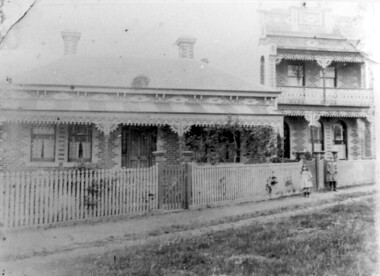
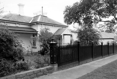
John Butler Maling, retired farmer, built his home on the corner of his property which extended from Weybridge Street to Whitehorse Road and from James to Ross Street. From 1853 he lived in a simple farmhouse located near the present Ross Street until he had 'Ancyra' built in c.1889 from bricks made from clay dug from a quarry on the property. This was located in the now-park in James Street. John Butler Maling Snr was born in Shepreth, Cambridgeshire. He married Kate Conlan in 1882 and they had 3 children - Silas, Alick and Zillah. He died in 1912 and is buried in Box Hill Cemetery. Often referred to as John Butler Maling Senior as he had a nephew by the same name. He also lived on a similar sized property known as 'The Willows', located to the west. He became the first Mayor of Camberwell. From c1936 til c1960 the property was used as a rest home (Ancyra Rest Home) and then a nursery (Pied Piper Nursery).This property is important as one of few remaining extant links to pre-urban Surrey Hills, and built from local material.A black and white photograph of a brick house with a slate roof and corrugated iron over the verandah and portico. A picket fence painted a dark colour features decorative finals on the tops of the posts.ancyra, house names, weybridge street, surrey hills, whitehorse road, james street, ross street, john butler maling (snr), mrs kate maling, silas maling, alick maling, zillah maling, miss kate conlan, box hill cemetery, ancyra rest home, pied piper nursery -
 Surrey Hills Historical Society Collection
Photograph, "Ancyra", 25 Weybridge Street, Surrey Hills
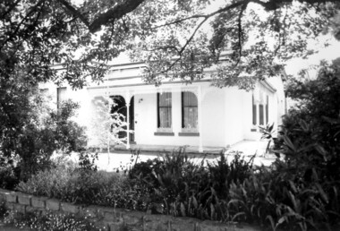
John Butler Maling, retired farmer, built his home on the corner of his property which extended from Weybridge Street to Whitehorse Road and from James to Ross Street. From 1853 he lived in a simple farmhouse located near the present Ross Street until he had 'Ancyra' built in c.1889 from bricks made from clay dug from a quarry on the property. This was located in the now-park in James Street. John Butler Maling Snr was born in Shepreth, Cambridgeshire. He married Kate Conlan in 1882 and they had 3 children - Silas, Alick and Zillah. He died in 1912 and is buried in Box Hill Cemetery. Often referred to as John Butler Maling Senior as he had a nephew by the same name. He also lived on a similar sized property known as 'The Willows', located to the west. He became the first Mayor of Camberwell. From c1936 til c1960 the property was used as a rest home (Ancyra Rest Home) and then a nursery (Pied Piper Nursery). This is one of relatively few surviving houses that provides links to pre0urban Surrey Hills. It is also built from locally quarried material.A black and white photograph of a house viewed through the front garden.ancyra, house names, weybridge street, surrey hills, james street, bricks, john butler maling senior, miss kate conlan, mrs kate maling, alick maling, silas maling, zillah maling, ancyra rest home, pied piper nursery, box hill cemetery -
 Surrey Hills Historical Society Collection
book, Early history of Wattle Park, Surrey Hills 1853-1915, 1984
Author: Alan Judge Holt amassed a significant collection of historical material related to the Surrey Hills area. Born in Moonee Ponds in 1912 to Edmund Holt and Ellen Ruby Sutton, he married Edna Jean Pallot in 1937. They lived at 62 Broughton Road, Surrey hills, had 3 sons and were strongly associated with the Surrey Hills Methodist Church. Alan was Secretary of the Victorian Lands Department and in his spare time recorded the occupancy of every property in Surrey Hills and Mont Albert at the beginning of each decade from 1890 to 1980. His collection of files and individual cards covers people, places, churches, clubs, businesses and other organisations in the area. Alan used this information to give talks and tours of the area and gifted his material to the local history collection through Jocelyn Hall.A spiral bound manuscript which includes a physical description of Wattle Park as well as covering aboriginal occupation, pastoral and timber cutting, the original purchasers and locations of neighbouring farms.back creek, wattle park, delany's paddock, cleary's paddock, blood's paddock, conran's paddock, udimore lodge, (mr) george thomas usher, (mr) orlando fenwick, phoenix grange, (mr) john filson, (mr) denis delany, (mr) john crimp, (mr) james atkinson, (mr) john lawler, (mr) henry de carle, (mr) walter craig, (mr) daniel dunn, (mr) frederick goyder, (mrs) eliza welch, metropolitan tramways, d h dureau, (mr) robert beckett, (mr) alexander gerald proudfoot, (mr) james conran, (mr) thomas blood, (mr) william smith, payne and glass -
 National Wool Museum
Book - Wool sample book
Book was given to Mr Robert 'Bob' Edward Mitchell in 1938. Mr Mitchell trained as a wool classer in the 1930's and was awarded this book as the senior prize. Mr. Mitchell grew up on the Moorabinda sheep property and is on the honour roll as a past student who served in World War II from Wharparilla West State School.Large black bound book containing 12 double-sided pages, each with several wool samples mounted to a blue paper with the name of sheep breed which the wool came from. Each page also has a loose sheet of wax paper over the wool. Book can be closed and secured with a length of black material which can be tied up. -
 National Wool Museum
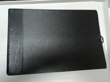
Album - Photo Album, 1 of 3, J W Allen, 1928-1929
This album is one of three albums compiled and owned by J W Allen, Secretary of New South Wales Grazier's, and is associated with the New South Wales Graziers Association world tour of sheep 1928-1929. This album contains photographs of travel, sheep, farms, stations, people and landscapes from around the world. Locations include Naples, Port Said, Suez, Birregurra (Vic), Alexandra (Vic), Ballangeich (Vic), Keith (SA), Mt Gambier (SA), Buckland Park (SA), Tasmania, Winton (QLD), Sydney Harbour, Canberra (ACT), Toowoomba (QLD), Rockhampton (QLD), Tocal (NSW), Deepwater (NSW), Glen Innes (NSW), Longreach (QLD), Moree (NSW), Barraba (NSW) and Mudgee (NSW). Properties depicted include Mooleric, Turkeith, Woolongoon, Minadale, Crower Station, Merrindie, Koomooloo Station, Cappeedee, Koonoona, Rathmore, Ellenthorpe, Camden Park Station, Glenlegh, Strathmore Station, Ilparran Station, Binneguy, Midkin, Terlings, Ashley, Bereen, Plumthorpe, Mayvale and Havilah. The album was found in a clean out at the Great Southern Agricultural Research Institute and donated to the National Wool Museum, along with other related material such as photographs, glass lantern slides and ephemera.Photo album with card cover and silk string binding. Inside are twenty four pages of brown carded paper with black and white photos and hand written black text. A white piece of paper with hand written text has been added to the inside front page.new south wales graziers association, world tour, sheep, farm, rural, agriculture, stations, mooleric, turkeith, woolongoon, minadale, crower, merrindie, koomooloo, cappeedee, koonoona, rathmore, ellenthorpe, camden park, glenlegh, strathmore, ilparran, binneguy, midkin, terlings, ashley, bereen, plumthorpe, mayvale, havilah, naples, port said, suez, birregurra, alexandra, ballangeich, keith, mt gambier, buckland park, tasmania, winton, sydney, canberra, toowoomba, rockhampton, tocal, deepwater, glen innes, longreach, moree, barraba, mudgee, merino -
 National Wool Museum
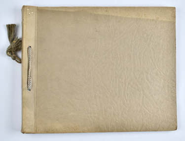
Album - Photo Album, 2 of 3, J W Allen, 1928-1929
This album is one of three albums compiled and owned by J W Allen, Secretary of New South Wales Grazier's, and is associated with the New South Wales Graziers Association world tour of sheep 1928-1929. This album contains photographs of travel, sheep, farms, stations, people and landscapes from around the world. Locations include Kenya, Kinangop, Naivasha, Elementeita, Lake Nakuru, Njoro, Namibia, Otjihavera, Mt Kenya, Isiolo, Yemen, Aden, Suez, River Jordan, Jerusalem, Hebron, Bethlehem, Beersheba, Galilee, Lake Tiberias, Mt Hermon, Canada, Mt Robson, Fraser River Canyon, British Columbia, Merrit, Canford, Alberta, Cardston, Pekisko Creek, Turner Valley, Calgary, Saskatoon, Manitoba, Winnipeg, Portage la Prairie, Niagara Falls, Quebec, Sainte-Anne-de-la-Pocatière and St Lawrence River. Properties depicted include Kenton Estates, Kekopey Ranch, Soysambu Ranch, Larmudiac, SX Ranch, Neilson's Ranch, EP Ranch and CX Ranch. The album was found in a clean out at the Great Southern Agricultural Research Institute and donated to the National Wool Museum, along with other related material such as photographs, glass lantern slides and ephemera.Photo album with card cover and silk string binding. Inside are twenty four pages of brown carded paper with black and white photos and hand written black text. A white piece of paper with hand written text has been added to the inside front page.new south wales graziers association, world tour, sheep, farm, rural, agriculture, ranch, travel, kenton estates, kekopey ranch, soysambu ranch, larmudiac, sx ranch, neilson's ranch, ep ranch, cx ranch, kenya, kinangop, naivasha, elementeita, lake nakuru, njoro, namibia, otjihavera, mt kenya, isiolo, yemen, aden, suez, river jordan, jerusalem, hebron, bethlehem, beersheba, galilee, lake tiberias, mt hermon, canada, mt robson, fraser river canyon, british columbia, merrit, canford, alberta, cardston, turner valley, pekisko creek, calgary, saskatoon, manitoba, winnipeg, portage la prairie, niagara falls, quebec, sainte-anne-de-la-pocatiere, st lawrence river -
 National Wool Museum
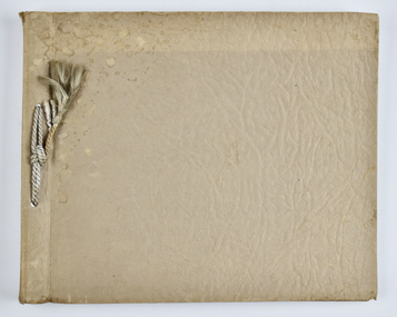
Album - Photo Album, 3 of 3, J W Allen, 1928-1929
This album is one of three albums compiled and owned by J W Allen, Secretary of New South Wales Grazier's, and is associated with the New South Wales Graziers Association world tour of sheep 1928-1929. This album contains photographs of travel, sheep, farms, stations, people and landscapes from around the world. Locations include Warren (NSW), Molong (NSW), Gamboola (NSW), Forbes (NSW), Hay (NSW), Conargo (NSW), Mokine (WA), New Zealand, Hawke's Bay, Southland, Lyttleton Harbour, Rotorua, Christchurch, Lincoln, Banks Peninsula, Akaroa, Pigeon Bay, Darfield, Rakahuri, Kaiwara, Highbank, Lake Heron, Mt Somers, Otago, Moa Flat, Waimahaka, Tarras, Moeraki and Blenheim. Properties depicted include Haddonrig, Egelabra, Bundemar, Redbank, Wandary, Tubbo Station, Coonong Station, Boonoke Station, Wanganella Estate, Yoorooga Estate, Taruna Farm, Harpenden Wool Works, Keppoch Estate, Bushey Park, Morven Downs, Meadowbank, Te Apiti and Penrose Farm. The album was found in a clean out at the Great Southern Agricultural Research Institute and donated to the National Wool Museum, along with other related material such as photographs, glass lantern slides and ephemera.Photo album with card cover and silk string binding. Inside are twenty four pages of brown carded paper with black and white photos and hand written black text. A white piece of paper with hand written text has been added to the inside front page.new south wales graziers association, world tour, sheep, farm, rural, agriculture, travel, new zealand, warren, molong, gamboola, forbes, hay, conargo, mokine, hawke's bay, southland, lyttleton, rotorua, christchurch, lincoln, banks peninsula, akoroa, pigeon bay, darfield, rakahuri, kaiwara, highbank, lake heron, mt somers, otago, moa flat, waimahaka, tarras, moeraki, blenheim, haddonrig, egelabra, bundemar, redbank, wandary, tubbo station, coonong station, boonoke station, wanganella estate, yoorooga estate, taruna farm, harpenden wool works, keppoch estate, bushey park, morven downs, meadowbank, te apiti, penrose farm -
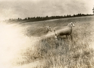 National Wool Museum
Photograph - Border Leicesters, J W Allen, 1928-1929
This photograph was found loose in the third of three albums compiled and owned by J W Allen, Secretary of New South Wales Grazier's, and is associated with the New South Wales Graziers Association world tour of sheep 1928-1929. The album contains photographs of travel, sheep, farms, stations, people and landscapes from around the world. Locations include Warren (NSW), Molong (NSW), Gamboola (NSW), Forbes (NSW), Hay (NSW), Conargo (NSW), Mokine (WA), New Zealand, Hawke's Bay, Southland, Lyttleton Harbour, Rotorua, Christchurch, Lincoln, Banks Peninsula, Akaroa, Pigeon Bay, Darfield, Rakahuri, Kaiwara, Highbank, Lake Heron, Mt Somers, Otago, Moa Flat, Waimahaka, Tarras, Moeraki and Blenheim. Properties depicted include Haddonrig, Egelabra, Bundemar, Redbank, Wandary, Tubbo Station, Coonong Station, Boonoke Station, Wanganella Estate, Yoorooga Estate, Taruna Farm, Harpenden Wool Works, Keppoch Estate, Bushey Park, Morven Downs, Meadowbank, Te Apiti and Penrose Farm. The album was found in a clean out at the Great Southern Agricultural Research Institute and donated to the National Wool Museum, along with other related material such as photographs, glass lantern slides and ephemera.Black and white image showing two sheep in a field.Back: [handwritten] Low, Highbank / Border ♀♀ / [printed] 68world tour, sheep, graziers, photograph, border leicester sheep -
 National Wool Museum
Photograph - Karakul Sheep, J W Allen, 1928-1929
This photograph was found loose in the second of three albums compiled and owned by J W Allen, Secretary of New South Wales Grazier's, and is associated with the New South Wales Graziers Association world tour of sheep 1928-1929. The album contains photographs of travel, sheep, farms, stations, people and landscapes from around the world. Locations include Kenya, Kinangop, Naivasha, Elementeita, Lake Nakuru, Njoro, Namibia, Otjihavera, Mt Kenya, Isiolo, Yemen, Aden, Suez, River Jordan, Jerusalem, Hebron, Bethlehem, Beersheba, Galilee, Lake Tiberias, Mt Hermon, Canada, Mt Robson, Fraser River Canyon, British Columbia, Merrit, Canford, Alberta, Cardston, Pekisko Creek, Turner Valley, Calgary, Saskatoon, Manitoba, Winnipeg, Portage la Prairie, Niagara Falls, Quebec, Sainte-Anne-de-la-Pocatière and St Lawrence River. Properties depicted include Kenton Estates, Kekopey Ranch, Soysambu Ranch, Larmudiac, SX Ranch, Neilson's Ranch, EP Ranch and CX Ranch. The album was found in a clean out at the Great Southern Agricultural Research Institute and donated to the National Wool Museum, along with other related material such as photographs, glass lantern slides and ephemera.Black and white image showing sheep in a paddock.world tour, sheep, graziers, photograph, karakul, winnipeg, canada, manitoba, agriculture -
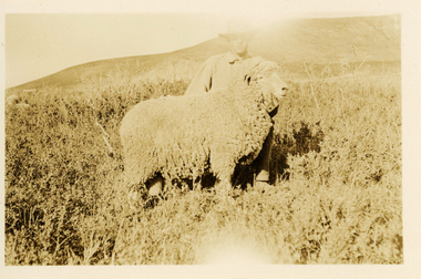 National Wool Museum
Photograph - 'Harvey' Ram at Neilson's Ranch, J W Allen, 1928-1929
This photograph was found loose in the second of three albums compiled and owned by J W Allen, Secretary of New South Wales Grazier's, and is associated with the New South Wales Graziers Association world tour of sheep 1928-1929. The album contains photographs of travel, sheep, farms, stations, people and landscapes from around the world. Locations include Kenya, Kinangop, Naivasha, Elementeita, Lake Nakuru, Njoro, Namibia, Otjihavera, Mt Kenya, Isiolo, Yemen, Aden, Suez, River Jordan, Jerusalem, Hebron, Bethlehem, Beersheba, Galilee, Lake Tiberias, Mt Hermon, Canada, Mt Robson, Fraser River Canyon, British Columbia, Merrit, Canford, Alberta, Cardston, Pekisko Creek, Turner Valley, Calgary, Saskatoon, Manitoba, Winnipeg, Portage la Prairie, Niagara Falls, Quebec, Sainte-Anne-de-la-Pocatière and St Lawrence River. Properties depicted include Kenton Estates, Kekopey Ranch, Soysambu Ranch, Larmudiac, SX Ranch, Neilson's Ranch, EP Ranch and CX Ranch. The album was found in a clean out at the Great Southern Agricultural Research Institute and donated to the National Wool Museum, along with other related material such as photographs, glass lantern slides and ephemera.Black and white image showing a man and a sheep in the foreground with mountains in the background.Back: [handwritten] Harvey ram / at Neilson’s / Harvey / Neilson’s ranch [printed] A 40world tour, sheep, graziers, photograph, canada, agriculture, cardtson, alberta -
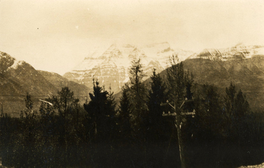 National Wool Museum
Photograph - Mount Robson, J W Allen, 1928-1929
This photograph was found loose in the second of three albums compiled and owned by J W Allen, Secretary of New South Wales Grazier's, and is associated with the New South Wales Graziers Association world tour of sheep 1928-1929. The album contains photographs of travel, sheep, farms, stations, people and landscapes from around the world. Locations include Kenya, Kinangop, Naivasha, Elementeita, Lake Nakuru, Njoro, Namibia, Otjihavera, Mt Kenya, Isiolo, Yemen, Aden, Suez, River Jordan, Jerusalem, Hebron, Bethlehem, Beersheba, Galilee, Lake Tiberias, Mt Hermon, Canada, Mt Robson, Fraser River Canyon, British Columbia, Merrit, Canford, Alberta, Cardston, Pekisko Creek, Turner Valley, Calgary, Saskatoon, Manitoba, Winnipeg, Portage la Prairie, Niagara Falls, Quebec, Sainte-Anne-de-la-Pocatière and St Lawrence River. Properties depicted include Kenton Estates, Kekopey Ranch, Soysambu Ranch, Larmudiac, SX Ranch, Neilson's Ranch, EP Ranch and CX Ranch. The album was found in a clean out at the Great Southern Agricultural Research Institute and donated to the National Wool Museum, along with other related material such as photographs, glass lantern slides and ephemera.Black and white image showing trees, power pole and power lines in the foreground and snow covered mountains in the background. world tour, sheep, graziers, photograph, canada, agriculture, british columbia, mount robson, mt robson -
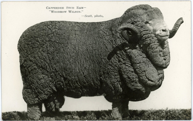 National Wool Museum
Postcard - 'Woodrow Wilson', Capeedee Stud Ram, Chas P Scott, 1926
This postcard was found loose in the first of three albums compiled and owned by J W Allen, Secretary of New South Wales Grazier's, and is associated with the New South Wales Graziers Association world tour of sheep 1928-1929. The album contains photographs of travel, sheep, farms, stations, people and landscapes from around the world. Locations include Naples, Port Said, Suez, Birregurra (Vic), Alexandra (Vic), Ballangeich (Vic), Keith (SA), Mt Gambier (SA), Buckland Park (SA), Tasmania, Winton (QLD), Sydney Harbour, Canberra (ACT), Toowoomba (QLD), Rockhampton (QLD), Tocal (NSW), Deepwater (NSW), Glen Innes (NSW), Longreach (QLD), Moree (NSW), Barraba (NSW) and Mudgee (NSW). Properties depicted include Mooleric, Turkeith, Woolongoon, Minadale, Crower Station, Merrindie, Koomooloo Station, Cappeedee, Koonoona, Rathmore, Ellenthorpe, Camden Park Station, Glenlegh, Strathmore Station, Ilparran Station, Binneguy, Midkin, Terlings, Ashley, Bereen, Plumthorpe, Mayvale and Havilah. The album was found in a clean out at the Great Southern Agricultural Research Institute and donated to the National Wool Museum, along with other related material such as photographs, glass lantern slides and ephemera.Photographic postcard with black and white image of a ram with white background, and black printed text.Front: CAPPEEDEE STUD RAM - / “WOODROW WILSON” / - Scott, photo Back: POST CARD / CORRESPONDENCE / ADDRESS ONLY / KODAK / AUSTRALIA / KODAK / AUSTRALIA / 16world tour, sheep, graziers, photograph, agriculture, capeedee, rams, stud, south australia, hallett, walter s murray -
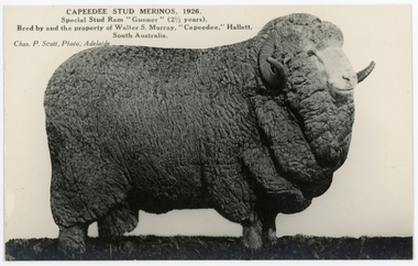 National Wool Museum
Postcard - 'Gunner', Capeedee Stud Ram, Chas P Scott, 1926
This postcard was found loose in the first of three albums compiled and owned by J W Allen, Secretary of New South Wales Grazier's, and is associated with the New South Wales Graziers Association world tour of sheep 1928-1929. The album contains photographs of travel, sheep, farms, stations, people and landscapes from around the world. Locations include Naples, Port Said, Suez, Birregurra (Vic), Alexandra (Vic), Ballangeich (Vic), Keith (SA), Mt Gambier (SA), Buckland Park (SA), Tasmania, Winton (QLD), Sydney Harbour, Canberra (ACT), Toowoomba (QLD), Rockhampton (QLD), Tocal (NSW), Deepwater (NSW), Glen Innes (NSW), Longreach (QLD), Moree (NSW), Barraba (NSW) and Mudgee (NSW). Properties depicted include Mooleric, Turkeith, Woolongoon, Minadale, Crower Station, Merrindie, Koomooloo Station, Cappeedee, Koonoona, Rathmore, Ellenthorpe, Camden Park Station, Glenlegh, Strathmore Station, Ilparran Station, Binneguy, Midkin, Terlings, Ashley, Bereen, Plumthorpe, Mayvale and Havilah. The album was found in a clean out at the Great Southern Agricultural Research Institute and donated to the National Wool Museum, along with other related material such as photographs, glass lantern slides and ephemera.Photographic postcard with black and white image of a ram with white background, and black printed text.Front: CAPEEDEE STUD MERINOS, 1926 / Special Stud Ram “Gunner” (2 ½ years). / Bred by and the property of Walter S. Murray, “Capeedee,” Hallett, / South Australia / Chas. P. Scott, Photo, Adelaide Back: POST CARD / CORRESPONDENCE / ADDRESS ONLY / KODAK / AUSTRALIA / KODAK / AUSTRALIAworld tour, sheep, graziers, photograph, agriculture, capeedee, rams, stud, south australia, hallett, walter s murray -
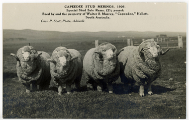 National Wool Museum
Postcard - Capeedee Stud Rams, Chas P Scott, 1926
This postcard was found loose in the first of three albums compiled and owned by J W Allen, Secretary of New South Wales Grazier's, and is associated with the New South Wales Graziers Association world tour of sheep 1928-1929. The album contains photographs of travel, sheep, farms, stations, people and landscapes from around the world. Locations include Naples, Port Said, Suez, Birregurra (Vic), Alexandra (Vic), Ballangeich (Vic), Keith (SA), Mt Gambier (SA), Buckland Park (SA), Tasmania, Winton (QLD), Sydney Harbour, Canberra (ACT), Toowoomba (QLD), Rockhampton (QLD), Tocal (NSW), Deepwater (NSW), Glen Innes (NSW), Longreach (QLD), Moree (NSW), Barraba (NSW) and Mudgee (NSW). Properties depicted include Mooleric, Turkeith, Woolongoon, Minadale, Crower Station, Merrindie, Koomooloo Station, Cappeedee, Koonoona, Rathmore, Ellenthorpe, Camden Park Station, Glenlegh, Strathmore Station, Ilparran Station, Binneguy, Midkin, Terlings, Ashley, Bereen, Plumthorpe, Mayvale and Havilah. The album was found in a clean out at the Great Southern Agricultural Research Institute and donated to the National Wool Museum, along with other related material such as photographs, glass lantern slides and ephemera.Photographic postcard with four rams standing together in a paddock.Front: CAPEEDEE STUD MERINOS, 1926 / Special Stud Sale Rams (2½ years). / Bred by and the property of Walter S. Murray, “Capeedee,” Hallett, / South Australia / Chas. P. Scott, Photo, Adelaide Back: POST CARD / CORRESPONDENCE / ADDRESS ONLY / KODAK / AUSTRALIA / KODAK / AUSTRALIAworld tour, sheep, graziers, photograph, agriculture, capeedee, rams, stud, south australia, hallett, walter s murray -
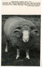 National Wool Museum
Postcard - Merrindie Dorset Stud, Pulford, 1927
This postcard was found loose in the first of three albums compiled and owned by J W Allen, Secretary of New South Wales Grazier's, and is associated with the New South Wales Graziers Association world tour of sheep 1928-1929. The album contains photographs of travel, sheep, farms, stations, people and landscapes from around the world. Locations include Naples, Port Said, Suez, Birregurra (Vic), Alexandra (Vic), Ballangeich (Vic), Keith (SA), Mt Gambier (SA), Buckland Park (SA), Tasmania, Winton (QLD), Sydney Harbour, Canberra (ACT), Toowoomba (QLD), Rockhampton (QLD), Tocal (NSW), Deepwater (NSW), Glen Innes (NSW), Longreach (QLD), Moree (NSW), Barraba (NSW) and Mudgee (NSW). Properties depicted include Mooleric, Turkeith, Woolongoon, Minadale, Crower Station, Merrindie, Koomooloo Station, Cappeedee, Koonoona, Rathmore, Ellenthorpe, Camden Park Station, Glenlegh, Strathmore Station, Ilparran Station, Binneguy, Midkin, Terlings, Ashley, Bereen, Plumthorpe, Mayvale and Havilah. The album was found in a clean out at the Great Southern Agricultural Research Institute and donated to the National Wool Museum, along with other related material such as photographs, glass lantern slides and ephemera.Photograph postcard with a black and white image of a ram, and printed black text.Front: MERRINDIE DORSET STUD, 1927. / “Merrindie 166” sired by “Symondsbury 264,” imp. Champion Adelaide / Royal Show, 1925. Champion Melbourne Royal Show, 1925. Bred by and / the property of W. S. Kelly, “Merrindie,” Giles Corner, South Australia. / Pulford Photo, Adelaide. Back: POST CARD / CORRESPONDENCE / ADDRESS ONLY / KODAK / AUSTRALIA / KODAK / AUSTRALIAworld tour, sheep, graziers, photograph, agriculture, rams, stud, south australia, merrindie, giles corner, w s kelly, pulford -
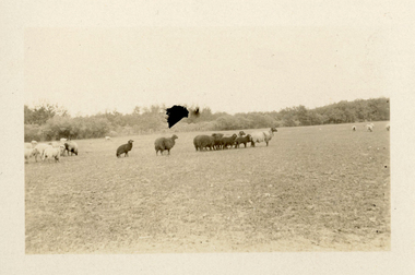
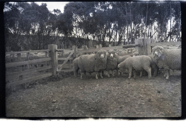 National Wool Museum
Negative - Sheep, J W Allen, 1928-1929
This negative was found loose in the first of three albums compiled and owned by J W Allen, Secretary of New South Wales Grazier's, and is associated with the New South Wales Graziers Association world tour of sheep 1928-1929. The album contains photographs of travel, sheep, farms, stations, people and landscapes from around the world. Locations include Naples, Port Said, Suez, Birregurra (Vic), Alexandra (Vic), Ballangeich (Vic), Keith (SA), Mt Gambier (SA), Buckland Park (SA), Tasmania, Winton (QLD), Sydney Harbour, Canberra (ACT), Toowoomba (QLD), Rockhampton (QLD), Tocal (NSW), Deepwater (NSW), Glen Innes (NSW), Longreach (QLD), Moree (NSW), Barraba (NSW) and Mudgee (NSW). Properties depicted include Mooleric, Turkeith, Woolongoon, Minadale, Crower Station, Merrindie, Koomooloo Station, Cappeedee, Koonoona, Rathmore, Ellenthorpe, Camden Park Station, Glenlegh, Strathmore Station, Ilparran Station, Binneguy, Midkin, Terlings, Ashley, Bereen, Plumthorpe, Mayvale and Havilah. The album was found in a clean out at the Great Southern Agricultural Research Institute and donated to the National Wool Museum, along with other related material such as photographs, glass lantern slides and ephemera.Black and white negative showing sheep in stockyards with trees and hill in background.agriculture, sheep, farming, stations, research, breeding, photography, travel -
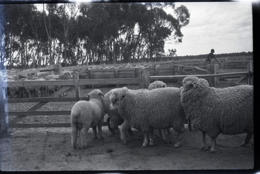 National Wool Museum
Negative - Sheep in Stockyards, J W Allen, 1928-1929
This negative was found loose in the first of three albums compiled and owned by J W Allen, Secretary of New South Wales Grazier's, and is associated with the New South Wales Graziers Association world tour of sheep 1928-1929. The album contains photographs of travel, sheep, farms, stations, people and landscapes from around the world. Locations include Naples, Port Said, Suez, Birregurra (Vic), Alexandra (Vic), Ballangeich (Vic), Keith (SA), Mt Gambier (SA), Buckland Park (SA), Tasmania, Winton (QLD), Sydney Harbour, Canberra (ACT), Toowoomba (QLD), Rockhampton (QLD), Tocal (NSW), Deepwater (NSW), Glen Innes (NSW), Longreach (QLD), Moree (NSW), Barraba (NSW) and Mudgee (NSW). Properties depicted include Mooleric, Turkeith, Woolongoon, Minadale, Crower Station, Merrindie, Koomooloo Station, Cappeedee, Koonoona, Rathmore, Ellenthorpe, Camden Park Station, Glenlegh, Strathmore Station, Ilparran Station, Binneguy, Midkin, Terlings, Ashley, Bereen, Plumthorpe, Mayvale and Havilah. The album was found in a clean out at the Great Southern Agricultural Research Institute and donated to the National Wool Museum, along with other related material such as photographs, glass lantern slides and ephemera.Black and white negative showing sheep in stock yards, with trees in background. A man is shown standing in the yards to the right hand side. agriculture, sheep, farming, stations, research, breeding, photography, travel