Showing 10926 items
matching the land
-
 Whitehorse Historical Society Inc.
Document, Notes on Job. Hone, n.d
Notes on Job Hone's arrival in Victoria in 1850.Notes on Job Hone's arrival in Victoria in 1850, one of the first people to discover gold at Avoca, returned to Box Hill in 1853 and bought land. he assisted in establishing most of the churches in the area.Notes on Job Hone's arrival in Victoria in 1850. hone, job, pioneers -
Whitehorse Historical Society Inc.
Article, Couple give land for park, 21/01/1967 12:00:00 AM
Article from The Age, 21 Jan 1967.Article from The Age, 21 Jan 1967, re Blackburn couple Arthur & Janet Cooke deciding to hand over their house and land to the Council on their death to keep as a sanctuary for birds, plants and flowers.Article from The Age, 21 Jan 1967. hooke, albert arthur, hooke, janet emily, wandinong sanctuary -
University of Melbourne, Burnley Campus Archives
Booklet, The University of Melbourne, The University of Melbourne Institute/Faculty of Land and Food Resources Postgraduate Handbook, 2003-2007
the university of melbourne, institute of land and food resources, faculty of land and food resources, postgraduates, handbook, courses -
 Warrnambool and District Historical Society Inc.
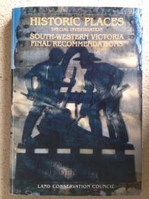
Book, Historic Places of South West Victoria
This is the third in a series of booklets produced by the Land Conservation Council in 1997 (176 pages). Booklets One and Two (1996) contained A Descriptive Report and Proposed Recommendations. The Final Recommendations include information on processes for protection of historic places, lists of significant places in the south-western region and aboriginal historic places. Attached inside the back cover are two maps showing the location of the significant places.This is a useful book as it lists the declared historic sites in the region and researchers will find the information helpful. This is a soft-cover book with a multi-coloured cover featuring a photograph of the Pioneers Memorial, Deep Lead. It has a red-coloured spine and back cover.Front Cover – Historic Places - Special Investigation - South-Western Victoria - Final Recommendations – Land Conservation Council Spine – Historic Places – South-Western Victoria – Final Recommendations – Land Conservation Council Back Cover – Historic Places, Final Rec., code used for retail sales warrnambool -
 Lorne Historical Society
Map, F W Niven Lithos, The Mountjoy Lorne Estate, 1889
In 1888 a company was formed to acquire and subdivide the land of the Mountjoy Brothers. The land totaled 197 acres and included Erskine House. The land colored red was that of the Mountjoys. The subdivision map was printed in 1889A paper map of the Mountjoy Estate Lorne , showing allotments, with their owners, and naming land use. It has four black and white line drawings , Erskine House, Mountain View’s, the Rapids, Erskine House sea view and Erskine Falls. The map is largely black and white with red and blue colouring. The map is mstuck to brown paper. lorne, subdivision map, erskine house, mountjoy brothers, -
 Lakes Entrance Historical Society
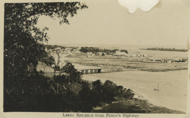
Postcard - First concrete bridge over North Arm Lakes Entrance Victoria, H D Bulmer, 1920 c
First concrete bridge over North Arm swamp land behind buildings on Esplanade low sand dunes on outer barrier Lakes Entrance VictoriaBlack and white postcard of township showing first concrete bridge over North Arm swamp land behind buildings on Esplanade low sand dunes on outer barrier Lakes Entrance VictoriaLakes Entrance from Princes Highwayislands, roads and streets, bridges, township -
 City of Kingston
Pamphlet - Colour, R. Malcolm Estate Agents et al, Last Chance Land Sale Heritage Estate Cheltenham, c.1994
Sales plan for land in the suburb of Cheltenham, bounded by Chesterville Road and Bernard Street, and incorporating Clendon Court, Tintern Grove and Tintern MewsThis land sale pamphlet illustrates one of the last subdivisions of the century in Cheltenham, incorporating house and land packages. It shows that land sales and subdivision for the area had slowed considerably by the end of the 1900s and that the infrastructure was significantly developed. Colour pamphlet advertising last chance land sale of Heritage Estate Cheltenham. Incorporates a map of the estate bordered by Chesterville Road and Bernard Street, and including Clenton Court, Tintern Grove and Tintern Mews.cheltenham, land sales, estate -
Whitehorse Historical Society Inc.
Document, Roberts' recollections, 1/10/2000 12:00:00 AM
On the occasion of 100 years of Federation.On the occasion of 100 years of Federation, John Roberts, former municipal officer (land uses and valuer) at Nunawading, recalls the problems families encountered with the provision of services for subdivisions and shopping in Nunawading in the 1950s and 1960s.On the occasion of 100 years of Federation.roberts, john, water supply, electricity supply, city of nunawading -
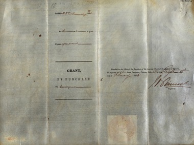
 Orbost & District Historical Society
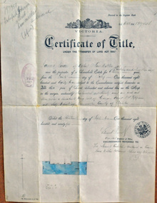
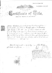
certificate of title, 1895
This certificate of title is a record of interests and rights affecting land owned by James Nixon of Orbost, sawmiller. James Nixon was a significant and influential citizen of Orbost's early years.A certificate of title of land -black print on white paper. It has a red stamp dated -"23 Sep 1895" overstamped with "fee 20/-" in black. It is signed "Edward Davies(?) Duncombe (?). at the bottom is a diagram of the block shaded in blue ink.nixon-james land certificate-of-title -
 Myrtleford and District Historical Society
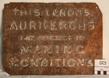
Gold Mining Sign
This sign was required to be displayed in the vicinity of gold mining sites. Myrtleford district was known to have had 100 sites within a ten mile radius of the town; the sign was recovered by Charlie McFadyen, a local prospector and fossicker, of some 60 yearsThe sign relates to local gold mining activity, a key source of wealth and employment from 1854 to the late 19th century. Such signs continued to be in use during the period between World War 1 and 2,including the period of the Great Depression.Tin rectangular mining sign embossed with a warningInscription: "THIS LAND IS AURIFEROUS AND SUBJECT TO MINING CONDITIONS"auriferous mining -
 Finnish Society of Melbourne
Deed document of Finnish Society of Melbourne, Office of titles Victoria, 1889
The Finnish Society of Melbourne purchased the old Red Robin Hosiery from Nelson Bros. proprietary Limited on the 4th of March 1974. The building was purchased as a home for the Society. On the document there are 9 members as joint proprietors. A trust document was created at the time.Their were joint proprietors. The document was not in the name of the Society. Additional trust document was made at the time.Large document Certificate of Title under the transfer of land staturecertificate of title -
 National Wool Museum
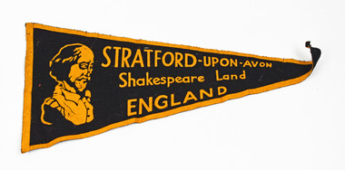
Pennant
STRATFORD-UPON-AVON Shakespeare Land ENGLANDstratford upon avon, england -
 Lakes Entrance Historical Society
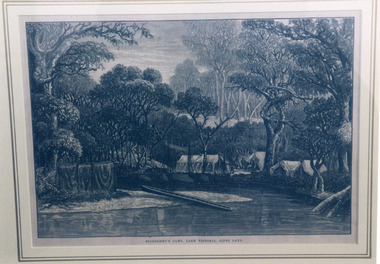
Photograph, Fish, Marie, 1999 c
Photographed from a book illustrationPhotograph of a woodcut depicting an early camp of fishermen on Lake Victoria, Gippsland Lakes, Victoria.Fishermen's Camp, Lake Victoria, Gipps Landvegetation, camping, arts and crafts -
Lakes Entrance Historical Society
Book, McGrath, Michelle, Trestle Bridge, 2005
Research, interpretation and management recommendations for the trestle bridge at Stony Creek, Nowa Nowa, Gippsland, VictoriaConservation and Land Management Culture Analysis Reporttransport, bridges -
 Bendigo Historical Society Inc.
Document - MARKS COLLECTION: PARISH PLAN OF WHITE HILLS
Sepia coloured map showing allotments in Parish of Sandhurst (White Hills) Written on LH side of map town and Suburban Lots White Hills Parish of Sandhurst. Scale is shown in chains. Surveyed by Horage Walker. Photo lithographed at the Department of Lands & Survey, Melbourne by J.Noone, Price 1/-. 6th. January 1865. Map shows Race Course Reserve at top of sheet, Municipal boundary is marked on LH side. Comments re vegetation throughout map. For example, poor soil timbered with Box scrub.on the back--Plan of Land White Hills Sandhurstbendigo, planning, white hills parish map, horage walker, j noone, department of lands and survey, -
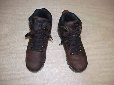
 National Wool Museum
Shoes, Womens hiking boots
Par tof the womens casual 'sportwool' uniform for the Winter Olympic games, 2002LAND ROVER GO EVERYWHERE FOOTWEAR Du Pont certified Thermolite Thin insulation LAND ROVER GO EVERYWHERE FOOTWEARfashion, shoes, costume, sport, salt lake city -
 National Wool Museum
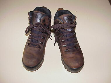
Shoes, Mens Hiking Boots
Part of the Mens Winter Olympic Uniform (as worn in the opening ceremony). However, these boots are unused.Pair of mens hiking boots as worn in the Opening Ceremony of the Winter Olympics, Salt Lake City, 2002Land Rover Go Everywhere Footwear Du Pont Certified Thermolite Thin Insulation Land Rover Go Everywhere Footwearfashion, costume, shoes, leather, sport, salt lake city -
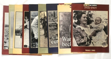 Orbost & District Historical Society
magazines/booklets, Our Land/Our Century, 1999
The Weekly Times was first published on September 11, 1869. In September 1875, The Weekly Times absorbed two other Melbourne-based rural publications, the Economist and Town and Country.In 1892 the Daily Telegraph company sold its buildings and mastheads to the Herald group, which has published The Weekly Times continuously since. In 1902 The Herald and Standard Newspaper Company Ltd changed its name to the present Herald and Weekly Times. These booklets were published as souvenir magazines to "celebrate 100 years on the land". These magazines are records of the rural history of Victoria.Nine of ten Weekly Times souvenir booklets/magazines titled Our Land, Our Century 1900-1999: Celebrating 100 Years on the Land. They contain pictures and stories of events related to rural Australia. Each edition covers ten years from 1900 -1989. The issue, 1990 -1999 is missing.magazine weekly-times souvenir rural-history -
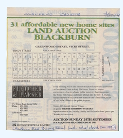 Whitehorse Historical Society Inc.
Article, Land Auction, Blackburn, 7/09/1994 12:00:00 AM
old Blackburn Advertisement in the Nunawading Gazette 7 September 1994Advertisement in the Nunawading Gazette 7 September 1994 for auction of the old Blackburn East Primary School (closed December 1993) land. Auction 25 September 1994. Greenwood Estate, Nicoli Street.old Blackburn Advertisement in the Nunawading Gazette 7 September 1994 land subdivision, bindy street, blackburn south, vicki street, sandra street, blackburn east primary school, no. 4800 -
 Federation University Historical Collection
Document, Victoria: Land Purchase, Edward Ager Wynne, 1856, 23 January 1856
.1 Document outlining the purchase of Lot No. 39: 16 acres, 3 roods, 9 perches situated in the County of Talbot, Parish of Glendaruel by Edward Ager Wynne of Melbourne for the sum of Seventeen Pounds Thirteen Shillings .2 Document outlining the purchase of Lot No. 30: 50 acres, 2 roods, 38 perches situated in the County of Talbot, Parish of Glendaruel bu Edward Ager Wynne of Melbourne for the sum of Fifty Pounds Fourteen Shillings and Nine Pence Both documents were witnessed by Major-General Edward Macarthur the Senior, Officer in Command of Our Land Forces Thick cream paper, hand writtenDate: 23 January 1856 Signature: E Macarthur - Major General of Our Land Forces Official Seal county of talbot, parish of glenaruel, acres, roods, perches, edward ager wynne, major-general, edward macarthue, land purchase agreement -
Federation University Historical Collection
1875
Land Purchase by James Cowan -
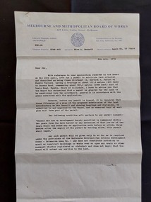 Mont De Lancey
Document - Land Permit to Subdivide Land, Melbourne and Metropolitan Board of Works, 5th July 1974
Vintage legal documents for land division in Victoria, especially those predating the Torrens system (October 1862), are often found in the Public Record Office Victoria (PROV). These documents, like deeds and Crown grants, can help trace the history of land ownership and division. A letter from the Melbourne and Metropolitan Board of Works stating the application by Mr M. H. Proctor of Wandin dated 23rd April, 1974 for a permit to subdivide land in Wandin Yallock has been approved by the Board on 23 April, 1974. There are conditions required. The letter is signed: 'Yours faithfully, (O.T. W. Cosgriff) Assistant Secretary' for 'Mr. M. H. Proctor, Queens Road, Wandin, 3139. 'Board's Reference: Appln No, TP 76484'legal documents, contracts, documents, indentures -
Whitehorse Historical Society Inc.
Article, Group Garden Turfed Out, 1992
The proposed Government sale of part of Nunawading Youth Residential Centre has forced one of Nunawading's Community Gardens out of its home.The proposed Government sale of part of Nunawading Youth Residential Centre has forced one of Nunawading's Community Gardens out of its home. The families involved are very upset, but the Council has no formal agreement with the Government over the use of the land.The proposed Government sale of part of Nunawading Youth Residential Centre has forced one of Nunawading's Community Gardens out of its home. community gardens, nunawading youth residential centre, community services victoria, nunawading community gardens -
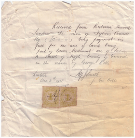 Linton and District Historical Society Inc
Receipt, Receipt for Payment for a Block of Land near Linton, 1918
Note that the block of land which was traded was not the block in Sussex Street, Linton on which the Sandows had a shop and house, but a block just outside the town boundary, near the Geelong Road (Linton-Naringhil Road). See map of Parish of Argyle for clarification.Photocopy of original handwritten receipt, which was for payment in full for a block of land situated just outside of Linton - Section A, Crown Allotment 1, Parish of Argyle. This land was purchased by Rubina (Ruby) Sandow from George Bolte in 1918. Receipt is for fifteen pounds, it is made out to "Rubinia Norwood Sandow" and is signed by Alf J. Smith, "for Geo. Bolte". Two Victorian Stamp Duty stamps are attached to the original document.rubina (ruby) sandow, george bolte, receipts, sale of land -
 Ringwood and District Historical Society
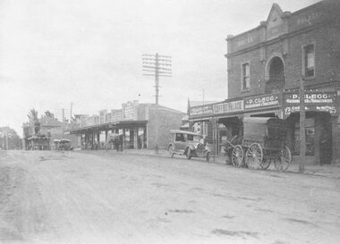
Photograph, Maroondah Highway Central, Ringwood. Coffee Palace and shops along Main Street between Adelaide Street and Melbourne Street. c1920's
Black and white photographWritten on back of photograph: "Land values - Main Street, Ringwood - land worth £50 pounds a foot." Image is taken from a land sale brochure and shows cars and horse drawn vehicles parked in front of buildings. -
 Whitehorse Historical Society Inc.
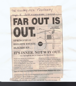
Article, Far out is out, 20/11/1994 12:00:00 AM
land sale on old Blackburn North Primary SchoolAdvertisement in Sunday Age for land sale on old Blackburn North Primary School land, appearing 20 November 1994. land sale on old Blackburn North Primary School land subdivision, springfield road, blackburn north, primrose street, blackburn north primary school -
Whitehorse Historical Society Inc.
Article, A win for all in give and take, 1990
Article about the conclusion reached through negotiation between land developers and residents of Vermont over subdivision of Wunderlich landArticle about the conclusion reached through negotiation between land developers and residents of Vermont over subdivision of Wunderlich landArticle about the conclusion reached through negotiation between land developers and residents of Vermont over subdivision of Wunderlich landrooks road vermont, mitcham road vermont, land subdivision, wunderlich limited -
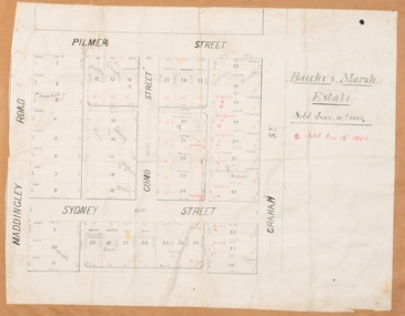 Bacchus Marsh & District Historical Society
Map, Bacchus Marsh Estate sold 30th June 1888 and sold 28 December 1895
Blocks of land in this area of Bacchus Marsh were sold in lots between 1888 and the late 1890s. This map shows sales made in 1888 and 1895.Single page map showing allotments of land bounded by Pilmer Street, Graham Street, Sydney Street and Maddingley Road (Grant Street) in Bacchus Marsh.The area is dissected by Como Street down the central area. 43 blocks of land are shown with the names of buyers or sellers in 1888 written in black in. Buyers or sellers for December 1895 are written in red ink. Part of a set of maps which are pasted into a bound volume containing 76 maps or plans in total. High resolution digital image stored on BMDHS computer network. bacchus marsh victoria maps, land sales bacchus marsh, pilmer street bacchus marsh, graham street bacchus marsh, sydney street bacchus marsh, como street bacchus marsh, maddingley road bacchus marsh, grant street bacchus marsh -
City of Moorabbin Historical Society (Operating the Box Cottage Museum)
Document, leaflet Box Cottage Museum, Bambra Press Ltd, 2019
Reprint 2019 by Bambra Press Ltd; Original Print 2016 This Leaflet / Brochure was compiled by City of Moorabbin Historical Society members Carol Poole, Joan Moore, Fran Bader for distribution to visitors, schools, libraries and local community to promote knowledge of Box Cottage Museum and the early settlement in the Moorabbin area. Glen Eira City Council Community Grant 2016 was obtained to finance printing by MKR Printing Ltd. Carnegie. Topics Box Cottage Museum, City of Moorabbin Historical Society, 1918 Chinese silk wedding dress, contact details, map, Box Family, Rietman Family, Land tenure records, Henry Dendy Special Survey 1841Reprint 2019, Original print 2016 Leaflet/Brochure compiled by CMHS members for distribution to visitors, schools, local community to promote knowledge of Box Cottage Museum and early settlement in the Moorabbin area1 x A4 glossy, colour, printed on both sides with photographsPage 1 BOX COTTAGE MUSEUM Page 2 William & Elizabeth Box, Land, August Rietman & Familycity of moorabbin, brighton, dendy henry, box william, box elizabeth, rietman august, rietman frieda, box cottage museum ormond, box alonzo, glen eira city council, city of moorabbin historical society, ormond, bentleigh, cheltenham, bambra press ltd port melbourne, -
 City of Kingston
Pamphlet - Colour, Roy Dunn Pty. Ltd, Central Corner Estate Moorabbin and Highett, c. 1923
Sales plan for land in the suburbs of Highett and Moorabbin, bordered by Point Nepean Road and Wickham Road East incorporating William StreetThe developing urban area of Highett and Moorabbin within the City of Kingston. This land sale pamphlet illustrates the subdivision of land within the municipality and the changing demographic of the district as new houses are constructed close to infrastructure.Colour pamphlet advertising for private sale land in the Central Corner Estate in Moorabbin and Highett. Incorporates a map of the estate bordered by Point Nepean Road and Wickham Road East, with subdivisions also available on both sides of William Street. Handwritten in blue pencil on subdivision plan: a tick is drawn on subdivisions 2-18 Handwritten in blue pencil on subdivision 6: a box with an x inside Handwritten in blue pencil on subdivisions 10 and 12: S Handwritten in black ink on front page: [indecipherable] / McKittricks Handwritten in grey pencil on rear page: McKilhick / Nepean Rd Handwritten in grey pencil on rear page upside down: 160000 / 15 8300 [crossed out] land sales, estate, highett, moorabbin