Showing 3040 items matching "victoria park"
-
 Federation University Historical Collection
Article - Article - Women, Federation University: Women of Note; Dr Doris Paton, Academic and Aboriginal Elder
... served on boards for Parks Victoria, the Victorian Aboriginal... on boards for Parks Victoria, the Victorian Aboriginal Heritage ...Dr Doris Paton is an accomplished academic and respected Aboriginal Elder with a passion for the advancement of First Nations People through education, and the reclamation and revival of Aboriginal languages across Australia. She graduated with a Bachelor of Arts (Social Science) from Monash University, Gippsland campus in 1993, and went on to complete a Graduate Diploma Education (Secondary); Master of Education Studies (Aboriginal Education); Master of Education (Aboriginal Education); and a PhD Philosophy (Education). Her skill and expertise have been acknowledged through roles as Director Vice-Chairperson of the Victorian Aboriginal Languages Corporation (VACL) and as Chairperson of the Victorian Indigenous Languages Implementation Reference Group, Victorian Curriculum Assessment Authority, where she developed the framework to accredit “Indigenous Languages of Victoria: Revival and Reclamation”, a VCE accredited subject contributing toward the preservation of Indigenous languages across Australia. A Federation University Council Member since 2020, Doris is also long-serving Director of the Nindi Ngujarn Ngarigo Monero Aboriginal Corporation; and has served on boards for Parks Victoria, the Victorian Aboriginal Heritage Council, and the East Gippsland School for Aboriginal Health Professionals. Her work has been presented at conferences including the World Indigenous Peoples Conference on Education, and recognised with several awards including the GippsTAFE Staff Excellence Awards in the Community Development, and Personal Achievement categories, The Wurreker Award for Community Based Employee, and the Parks Victoria Regional Achiever Award.women of note, federation university, doris paton, aboriginal elder, academic, aboriginal languages, monash university gippsland, graduate diploma education, bachelor of arts, master of education, phd philosophy, victorian aboriginal languages corporation, vacl, councillor -
City of Kingston
Photograph - Black and white, 3 March 1954
... , Cheltenham Park, Victoria Golf Club and Jack Barker Oval are visible... right), Friendship Square, Cheltenham Park, Victoria Golf Club ...Cheltenham and Moorabbin are suburbs within the City of Kingston that were originally established as rural market gardening communities The area is bordered by Highett and Mentone. The market gardens, farms and paddocks have gradually been sub-divided into housing and industrial estates. Highett is developed with residential homes but was also the site of major facilities such as the Highett Gas Works. This aerial image covers a diverse section of the City of Kingston, taking in the suburbs of Moorabbin, Cheltenham, Highett and Mentone Residential housing development is prominent along the Frankston Railway line and the area still retains extensive market gardens and paddocks yet to be converted to a large industrial and commercial zone.Aerial photograph of Mentone, Cheltenham and Moorabbin within the City of Kingston. The area depicted in this 1954 aerial view includes Warrigal Road and Centre Dandenong Road intersection (top left); Charman Road, Patty Street, Bourke Street, Collins Street Mentone (top right); Keys Road Moorabbin (bottom left); Bay Road, Cheltenham (bottom right), Friendship Square, Cheltenham Park, Victoria Golf Club and Jack Barker Oval are visible. Nepean Highway and the Frankston railway line run centrally through the image. Highett Gasworks is also evident.White handwriting and type [indecipherable]. White image of clockface White image of compass White type 42956 Black handwriting 3/3/54 Williams [indecipherable] Black pencil: S [arrow] Black ink: 3/3/1954cheltenham, moorabbin, mentone, highett, market gardens -
 Wooragee Landcare Group
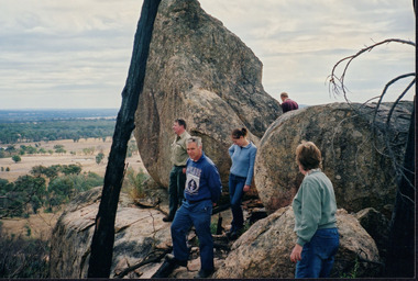
Photograph, circa April 2003
... Chiltern National Park is located near Chiltern in Victoria. It's... Chiltern National Park is located near Chiltern in Victoria. It's ...This photograph was taken in the Mount Pilot Chiltern National Park. It was taken during a search for the tiger quoll conducted by a team of volunteers from the Wooragee Landcare Group. The tiger quoll is also known as the spotted-tail quoll and is found in the national park. The 2003 bushfires caused worry for the safety of the tiger quoll, hence the need for a search for it. Mount Pilot Chiltern National Park is located near Chiltern in Victoria. It's most notable landmarks include Mt Pilot and Woolshed Falls. It also has many mines from the Gold Rush in the late 1800s. It is home to much flora and fauna, including the tiger quoll. The park is also home to the box-ironbark forest that once was present in most of north-eastern Victoria. The park is a large tourist destination as in there are many bushwalks and other attractions for visitors. In 2003, bushfires raged through Mount Pilot National Park and destroyed much of the environment. Some of this damage can be seen in the burnt trees in the picture. This photograph represents the work that goes into protecting a important species like the tiger quoll and there has been much work done to preserve it. This photograph was taken when the Wooragee Landcare group went to ensure the survival of this species, highlighting how the tiger quoll is being protected. This photograph also demonstrates the significance of Mount Pilot Chiltern National Park. The park has many special flora and fauna that can only be found in this area. For example, the box-ironbark forest and the tiger quoll. The forest used to stretch over much of north-eastern Victoria and is therefore reminiscent of what that area of Victoria was once like. This park is historical for this reason but it is also historical through it being once goldfields from the Gold Rush in the 1800s.Landscape coloured photograph printed on gloss paperReverse: WAN NA 0ANA2N0 NNN- 1 1636 / [PRINTED] (No.8) / 922mount pilot, mount pilot chiltern national park, chiltern, victoria, landmark, woolshed falls, gold rush, tiger quoll, flora, fauna, spotted tail quoll, marsupial, andy murray, andy murray quolls, carnivorous marsupial, forests, rainforests, coastal heathlands, woodlands, photograph, species, wooragee, wooragee landcare group, wooragee landcare, bushfires, identification, search, dna, droppings, box ironbark forest, ironbark, box iron bark -
 Victorian Interpretive Projects Inc.
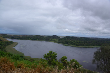
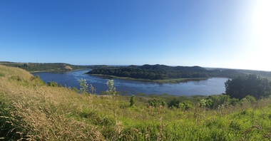
Photograph - Colour, Clare Gervasoni, Tower Hill, Victoria, 2013, 2013
... , and features a lake and wetlands. It became Victoria's first national... Victoria's first national park in 1892, but by the 1930s the early ...The Tower Hill Reserve is located inside a dormant volcano, and features a lake and wetlands. It became Victoria's first national park in 1892, but by the 1930s the early settlers had cleared much of the land for grazing, cropping and quarrying. In the 1960s the bare hills and islands were revegetated based in species identified from Eugene von Guerard's painting of Tower Hill. Tower Hill was formed around 30,000 years ago in a violent volcanic eruption. The initial eruption created the outer rim of the volcano, and later smaller eruptions formed the internal hills that are evident today. The layers of volcanic ash layers include artefacts relating to indigenous communites.A series of colour digital photographs showing Tower Hill, near Port Fairy, Victoria. Tower Hill is an extinct volcano.tower hill, volcano, extinct -
 Mordialloc College Alumni Association Inc (MCAA)
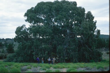
Photograph, 1979 Wyperfeld Old Be-al River Red Gum Tree, 1979
... in front of “Old Be-al” in Victoria’s Wyperfeld National Park, near... students standing in front of “Old Be-al” in Victoria’s Wyperfeld ...1979 - Mordialloc-Chelsea High School students standing in front of “Old Be-al” in Victoria’s Wyperfeld National Park, near Outlet Creek. It has been described as one of the most magnificent River Red Gums in the land. This glorious tree with foliage hanging to the ground escaped the fire of 1959 but not the fire of 1982 that damaged it badly. It lives on but has also suffered from lack of water and is now inaccessible to the public in a reference area. The MCAA has provided this image to the Friends of Wyperfeld National Park. Mordialloc-Chelsea High School students visited the Wyperfeld National park annually for the biology and geography Year 11 school camp.Example of a River Red Gum at Wyperfeld National Park.Digital image reproduced from colour slide.big desert fire 1959, mordialloc-chelsea high school camp, wyperfeld national park, fire 1982, old be-al river red gum -
Kew Historical Society Inc
Archive (Sub-series) - Subject File, East Kew Women’s Club, 1945-70, 1958
... in Victoria Park, Kew. At the fifth meeting of the group, a committee... in Victoria Park, Kew. At the fifth meeting of the group, a committee ...Various partiesReference, Research, InformationSecondary Values (KHS Imposed Order)Most of the original manuscripts of the Club (attendance registers, minutes of meetings, histories etc.,) are kept separately in archival boxes. The reference file contains a copy of the 9-page history of the Club’s history from 1945-65 a newspaper clipping relating to a 25-year anniversary lunch.kew (vic) - history, kew east (vic) - community groups, kew east (vic) - womenkew (vic) - history, kew east (vic) - community groups, kew east (vic) - women -
Kew Historical Society Inc
Archive (Sub-series) - Subject File, Kew Historical Society, Gardens (Kew), 1979
... 1845-6 on the Willsmere Farm, red gums in Victoria Park, pine... gums in Victoria Park, pine trees in the Cemetery dating from ...Various partiesReference, Research, InformationSecondary Values (KHS Imposed Order)Correspondence and newspaper articles/clippings relating to historic gardens in Kew. The oldest item is a letter from the National Trust Victoria announcing their two-year garden study and seeking information on gardens in Kew. Mavis Rolley, Secretary of the Society, made handwritten notes in response, which are kept in the file. She refers to: the pear trees planted by William Oswin in c. 1845 near what is now the Burke Road Bridge (she notes that a search for the trees at the time of the construction of the Eastern Freeway was unsuccessful), a camellia planted by the Dannocks near the corner of Derby and High Street, a c.1876 pine tree in Field Place, Henty Court, an 1875 Moreton Bay fig at Tarring, Ruyton, a Moreton Bay fig at Roxeth, Trinity Grammar, an 1840s oak tree and a 120-year old olive tree at Fairholme, Barry Street, 1870 pine trees at D’Estaville, Barry Street, trees at Turinville, Barnard Grove, dating to 1846, pine trees dating from 1845-6 on the Willsmere Farm, red gums in Victoria Park, pine trees in the Cemetery dating from the 1860s, trees in the Alexandra Gardens and at Kew Primary School, palm trees at La Verna, Sackville Street dating from the 1890s, the trees and gardens at Ross House (Charleville), and the trees at Merridale, Sackville Street which date from the 1880s, a magnolia at Lalla Rookh. These dates are probably highly contestable. Other handwritten notes from 1979 about significant gardens included: 5 Molesworth Street, Red Bluff - Redmond Street (garden now destroyed), Campion House, Studley Park Road, Raheen, Studley Park Road, Ross House, Cotham Road (Charleville), 7 Adeney Avenue, 20-21 Belmont Avenue, 52 Mary Street, an Edna Walling garden on the corner of Argyle Road and Victor Avenue, Merridale, Sackville Street, Roseneath, and Reno, St John’s Parade.gardens - private - kew (vic), garden design - kew (vic), kew horticultural societygardens - private - kew (vic), garden design - kew (vic), kew horticultural society -
 Bendigo Historical Society Inc.
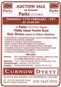
Document - IAN DYETT COLLECTION: AUCTION CATALOGUE - PARKS VICTORIA
... on account of Parks Victoria, on 27th February 1997 at San Remo... Catalogue - Parks Victoria Leigh Hart Ian Dyett Curnow Dyett J H ...White paper catalogue with brown printing for a sale on account of Parks Victoria, on 27th February 1997 at San Remo. For sale were marine & general service equipment, boat, crane, forklift, metal shop and woodworking machinery, pnu. & power tools, outboard motor, winches, trailers, hardwood & railway line, office furniture & equipment, nuts & bolts and hydraulic underwater tools. Announcement printed in the front of catalogue mentions that J. H. Curnow & Son Pty. Ltd. Are combining their name with the Dyett family and trading as Curnow Dyett, Real Estate Agents, Auctioneers and Qualified Valuers.business, auctioneers, curnow dyett, ian dyett collection - auction catalogue - parks victoria, leigh hart, ian dyett, curnow dyett, j h curnow & son pty ltd -
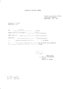 National Vietnam Veterans Museum (NVVM)
Document, Certificate of Discharge, AAF A16, 27/10/1972 12:00:00 AM
... by cover letter from Central Army Records Office, Albert Park... Central Army Records Office, Albert Park Barracks, Victoria ...Formal notification of discharge from permanent military forces of the Commonwealth of Australia, stuck into brown linen card cover bearing Coat of Arms of the Commonwealth of Australia. Register number P123910, the document was assigned to Private Neil Ernest Swainston , Rifleman, on 27/10/72 after 1 year and 183 days of effective service. Document is accompanied by cover letter from Central Army Records Office, Albert Park Barracks, Victoria.discharge certificate, national service - australia, swainston collection -
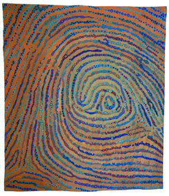 National Wool Museum
Quilt, Ms Suzanne Reid, Klimt Print #2, 2017
... 2017, held at the Queen Victoria Art Gallery (Royal Park... Australia 2017, held at the Queen Victoria Art Gallery (Royal Park ...Called "Klimt Print #2". Winning quilt in the 2017 Expressions Wool Quilt Prize Statement: "Every finger print is unique just as the art of Gustav Klimt is unique leaving an imprint for us which only he could leave." Art Quilt Australia 2017, held at the Queen Victoria Art Gallery (Royal Park location) Launceston, Tasmania, includes the 2017 winners of the prestigious Expressions Wool Quilt Prize (sponsored by the National Wool Museum) and the OZQN Award of ExcellenceWhole cloth painted quilt, hand wool embroidery, wool thread and metallic thread quilting.Klimt Print #2 Sue Reid -
 Parks Victoria - Mount Buffalo Chalet
Cabinet, cutlery
... - Significance Assessment, Prepared for Parks Victoria, 2011)...Parks Victoria - Mount Buffalo Chalet Mount Buffalo Road ..."The Chalet has 8 cutlery cabinets, all in the same undecorated Edwardian style, with tapered legs and slightly flared feet. They were identified in the 1992 inventory and listed on the Third schedule ... The cutlery cabinets and serving table probably date from the earliest years of the 1925-26 Dining Room ... Although the items lack a recorded provenance, their stylistic unity implies that they are part of a specific set of Chalet furnishings. Such items derive their meaning from their relationship with other furnishings and objects in the setting where they were originally used, with each complimenting the other." (Pg 77. Historica, Cultural heritage projects - Mt Buffalo Chalet Collection - Significance Assessment, Prepared for Parks Victoria, 2011)Listed in Draft Inventory of Significant Collection Items. (Pg 162. Historica)8 x small cabinets with 2 cutlery drawers each and wire to hang towels or curtains on underneath the drawers. Lower open shelf under drawers to store crockery. Some cabinets have laminex on top. (later addition) -
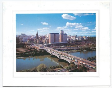 Melbourne Legacy
Card - Document, Christmas Cards (for fundraising)
... Road (Christmas 1972) A bush track at Wonga Park Victoria... (Christmas 1972) A bush track at Wonga Park Victoria by Dudley Drew ...Legacy raised funds from the sale of Christmas cards for many years. The years these were used is unknown but they illustrate the subjects chosen by Legacy. They were: Princes Bridge and Melbourne City 1970 Flinders Street form the Melbourne railway station (Christmas 1968) Melbourne from the South, near St Kilda Road (Christmas 1972) A bush track at Wonga Park Victoria by Dudley Drew (Christmas 1974) Unknown years: Three wise men, dog with holly, three children around baby Jesus. These came from a selection of cards and order forms from 1960-1974 were part of a scrapbook of Legacy material, mostly promotional material, from the 1960s to 1970s.An example of fundraising material issued by Legacy in the 1960s and 1970s.A sample of Legacy Christmas Cards from a variety of years.fundraising, christmas cards -
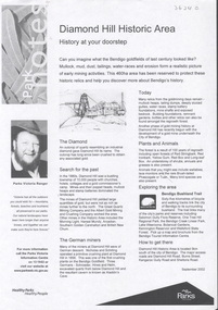 Bendigo Historical Society Inc.
Document - DIAMOND HILL HISTORIC AREA PARKS VICTORIA
... Document, two pages, prepared by Parks Victoria in relation... by Parks Victoria in relation to the Diamond Hill Historic Area ...Document, two pages, prepared by Parks Victoria in relation to the Diamond Hill Historic Area. Contains information regarding the history of the area; German Miners; Plants and animals. On second page is a map of the area showing historic features: Deborah Consolidated Gold workings Red, White and Blue Extended gold workings Goldfields Extended gold workings Dead Dog Gully, alluvial gold workings Glasgow & Golconda Gold workings and tramway Surface gold mining site Hansel Mundy gold workings Bendigo Goldfields Pty gold workings Stafford gold workings Langdon gold workings Great Opossum Gully alluvial gold workingsbendigo, mining, diamond hill -
City of Kingston
Photograph - Black and white, 5 January 1984
... of this image includes Cheltenham Park and Victoria Golf Club.... of this image includes Cheltenham Park and Victoria Golf Club ...Moorabbin, Cheltenham and Highett are suburbs in the City of Kingston with a diverse mix of development and zoning. The market gardens, farms and paddocks have gradually been sub-divided into housing and industrial estates and associated infrastructure such as schools and shopping facilities. The area includes many parks, reserves and golf courses.This aerial image covers a diverse section of the City of Kingston, taking in the suburbs of Cheltenham, Moorabbin, Beaumaris and Highett. By 1984, the market gardens of the district have been replaced by housing and factories. The Gas and Fuel state-of-the-art Scientific Services Department is visible on Nepean Highway Highett. The CSIRO Highett site can also be seen. Both sites have now been demolished and have undergone remediation. The Southland site is visible and yet to be redeveloped by Westfield. This image portrays the diversity of development in the City of Kingston with a mixture of green spaces, housing and commercial and industrial features.Aerial photograph of Cheltenham, Beaumaris, Moorabbin and Highett within the City of Kingston. The area depicted in the 1984 aerial view includes Eden Street and Edward Street, Cheltenham (top left), Weatherall Road and Reserve Road, Cheltenham/Beaumaris (top right), Turner Road and Chesterville Road, Moorabbin (bottom left), Nepean Highway (left section), Graham Road and Middleton Street, Highett (bottom right). A large section of this image includes Cheltenham Park and Victoria Golf Club.White text: 3831-219 Lens information [indecipherable] RINGWOOD M/S 7922-3 RUN 15 Clockface image 5,300' ASL VIC DLS© 5-1-84cheltenham, highett, industrialisation, urbanisation, moorabbin, beaumaris -
 Ballarat Heritage Services
Photograph - Colour, Tower Hill, 2016, 31/12/2016
... became Victoria’s first National Park. In 1961, Tower Hill became.... In 1892 Tower Hill became Victoria’s first National Park. In 1961 ...Tower Hill is a volcanic formation believed to have erupted about 32,000 years ago. Its formation is known as a "nested maar" and it is the largest example of its type in Victoria. During formation, molten lava pushed its way up through the Earth’s crust and encountered a layer of water-bearing rock. Violent explosions followed creating a shallow crater which later filled with water to form the lake. Further eruptions occurred in the centre of this crater, creating the islands and cone shaped hills. In 1892 Tower Hill became Victoria’s first National Park. In 1961, Tower Hill became a State Game Reserve under the then Fisheries and Wildlife Department and a major re-vegetation program began. (https://www.towerhill.org.au/index.php/about-reserve/history, accessed 23 December 2019)A number of photographs taken at Tower Hill, including the lakes, volcanic ash layer, and koala.tower hill, ash layer, volcano -
 Ballarat Heritage Services
Photograph - Image, Tower Hill, Victoria, c1918, c1918
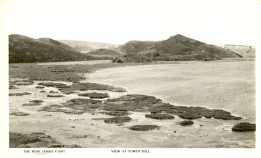
... became Victoria’s first National Park. In 1961, Tower Hill became.... In 1892 Tower Hill became Victoria’s first National Park. In 1961 ...Tower Hill is a volcanic formation believed to have erupted about 32,000 years ago. Its formation is known as a "nested maar" and it is the largest example of its type in Victoria. During formation, molten lava pushed its way up through the Earth’s crust and encountered a layer of water-bearing rock. Violent explosions followed creating a shallow crater which later filled with water to form the lake. Further eruptions occurred in the centre of this crater, creating the islands and cone shaped hills. In 1892 Tower Hill became Victoria’s first National Park. In 1961, Tower Hill became a State Game Reserve under the then Fisheries and Wildlife Department and a major re-vegetation program began. (https://www.towerhill.org.au/index.php/about-reserve/history, accessed 23 December 2019)Black and white image of Tower Hill, near Koroit, Victoria.tower hill, volcano, crater -
 Ballarat Heritage Services
Photograph - Colour photograph, Tower Hill, 2016, 23/12/2015
... became Victoria’s first National Park. In 1961, Tower Hill became.... In 1892 Tower Hill became Victoria’s first National Park. In 1961 ...Tower Hill is a volcanic formation believed to have erupted about 32,000 years ago. Its formation is known as a "nested maar" and it is the largest example of its type in Victoria. During formation, molten lava pushed its way up through the Earth’s crust and encountered a layer of water-bearing rock. Violent explosions followed creating a shallow crater which later filled with water to form the lake. Further eruptions occurred in the centre of this crater, creating the islands and cone shaped hills. In 1892 Tower Hill became Victoria’s first National Park. In 1961, Tower Hill became a State Game Reserve under the then Fisheries and Wildlife Department and a major re-vegetation program began. (https://www.towerhill.org.au/index.php/about-reserve/history, accessed 23 December 2019)Panaramic view of Tower Hill, Victoria.tower hill, volcano, crater -
 Ballarat Heritage Services
Photograph - Photograph - Black and White, Tower Hill, Victoria
... became Victoria’s first National Park. In 1961, Tower Hill became.... In 1892 Tower Hill became Victoria’s first National Park. In 1961 ...Tower Hill is a volcanic formation believed to have erupted about 32,000 years ago. Its formation is known as a "nested maar" and it is the largest example of its type in Victoria. During formation, molten lava pushed its way up through the Earth’s crust and encountered a layer of water-bearing rock. Violent explosions followed creating a shallow crater which later filled with water to form the lake. Further eruptions occurred in the centre of this crater, creating the islands and cone shaped hills. In 1892 Tower Hill became Victoria’s first National Park. In 1961, Tower Hill became a State Game Reserve under the then Fisheries and Wildlife Department and a major re-vegetation program began. (https://www.towerhill.org.au/index.php/about-reserve/history, accessed 23 December 2019)Black and white photograph of Tower Hill devoid of trees.tower hill, crossley, volcano -
 Ballarat Heritage Services
Photograph - Colour, Volcanic Crater at Tower Hill, 2017, 2017
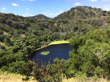
... became Victoria’s first National Park. In 1961, Tower Hill became.... In 1892 Tower Hill became Victoria’s first National Park. In 1961 ...Tower Hill is a volcanic formation believed to have erupted about 32,000 years ago. Its formation is known as a "nested maar" and it is the largest example of its type in Victoria. During formation, molten lava pushed its way up through the Earth’s crust and encountered a layer of water-bearing rock. Violent explosions followed creating a shallow crater which later filled with water to form the lake. Further eruptions occurred in the centre of this crater, creating the islands and cone shaped hills. In 1892 Tower Hill became Victoria’s first National Park. In 1961, Tower Hill became a State Game Reserve under the then Fisheries and Wildlife Department and a major re-vegetation program began. (https://www.towerhill.org.au/index.php/about-reserve/history, accessed 23 December 2019)Colour photographs of a lake in a volcanic crater at Tower Hill, Victoria. volcano, crater, lake, tower hill -
 Parks Victoria - Mount Buffalo Chalet
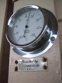
Gauge, temperature
... for Parks Victoria, 2011)...Parks Victoria - Mount Buffalo Chalet Mount Buffalo Road ...Appears to be original to Mt Buffalo Chalet. "A number of specific items, which have been useful in the day to day operations of the Chalet, remain in the building with each complementing the other to provide context, meaning and character to their setting. Items such as the hall porter bell, the many signs providing information to the guests, the wall clock, barometer and dinner bell point to the Chalet being a well-run social institution with a pleasant environment for rest, recreation and congenial company." (Pg 81 Historica, MBCC) This temperature gauge has a plaques inscribed "Presented by C.P Sanderson 7/08/1973. It is not known who this person was. Listed in Draft Inventory of significant Collection items. A.3 Fixtures and fittings. (Pg165 Historica Cultural Heritage Projects. Mount Buffalo Chalet collection. Prepared for Parks Victoria, 2011)Listed in Draft Inventory of Significant Collection ItemsSmall circular silver coloured temperature gauge mounted to wall. Plaque attached below temperature gauge. Face is white and has a glass cover.Plaque below barometer: "Presented by C P Sanderson / 7 - 8- 1973" -
 Parks Victoria - Gabo Island Lightstation
Bottle
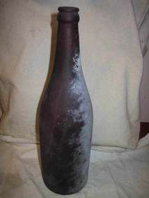
... for Melbourne Bitter. The Parks Victoria inventory indicates...Parks Victoria - Gabo Island Lightstation Gabo Island ...This dark brown bottle with lip, collar, neck and gently sloping shoulder, was made by the Bottle Co. of Victoria P/L for Melbourne Bitter. The Parks Victoria inventory indicates that the bottle dates to 1925. Still brewed today, Melbourne Bitter has been made since 1904, when the Melbourne Cooperative Brewery in Abbotsford was formed by well known pub owners that included Henry Young of Young & Jacksons, and future Lord Mayor Sir Stephen Morrell. They made four beers – Abbotsford Stout (which became Abbotsford Invalid Stout in 1909), Abbots Lager, Melbourne Bitter and Abbotsford Sparkling Ale. Of those, Melbourne Bitter and the Invalid Stout remain largely unchanged and both are now brewed by the South African owned CUB. The bottle was found in the sea or on the island.Whatever their provenance, they have an association with an event or activity on Gabo Island and for this reason have second level contributory significance for their potential to yield information relating to the cultural history of the lightstation.Dark brown glass bottle, tall with gradual tapering to a narrow opening. Slightly misshapen. White coating on one side.Within a club motif, "M.B.C.V" "The property of the manufacturers. / Bottle co of Victoria Pty Ltd" "6 1925" -
 Ballarat Heritage Services
Photograph - Colour photograph, Tower Hill, 2022, 24/12/2022
... became Victoria’s first National Park. In 1961, Tower Hill became... became Victoria’s first National Park. In 1961, Tower Hill became ...Tower Hill is a volcanic formation believed to have erupted about 32,000 years ago. Its formation is known as a "nested maar" and it is the largest example of its type in Victoria. During formation, molten lava pushed its way up through the Earth’s crust and encountered a layer of water-bearing rock. Violent explosions followed creating a shallow crater which later filled with water to form the lake. Further eruptions occurred in the centre of this crater, creating the islands and cone shaped hills. In 1892 Tower Hill became Victoria’s first National Park. In 1961, Tower Hill became a State Game Reserve under the then Fisheries and Wildlife Department and a major re-vegetation program began. (https://www.towerhill.org.au/index.php/about-reserve/history, accessed 23 December 2019)Panaramic view of Tower Hill, Victoria.tower hill, volcano, crater -
 Otway Districts Historical Society
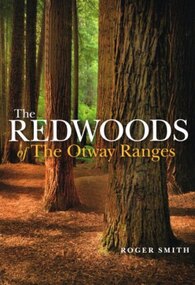
Book, Lothian Custom Publishing, The redwoods of the Otway Ranges. Roger Smith, January 2015
... Park in Victoria's south-west. It was originally planted...264 Danks Street, Middle Park, Melbourne, Victoria... Otway National Park in Victoria's south-west. It was originally ...This book is the remarkable story of the world's tallest tree species, the Redwood, growing in the Great Otway National Park in Victoria's south-west. It was originally planted by Victorian foresters for experimental purposes on land abandoned by the early settlers. The Coast Redwood, native of California, is now thrives in the Otways alongside the famous eucalypt, the towering Mountain Ash. The majestic Otway Redwoods, still in their youthful growth phase, have withstood adversity caused by fire, landslide, lighting and chainsaws, while the ongoing political debate about the conservation of the valuable forest resources continues.The redwoods of the Otway Ranges. Roger B. Smith. Lothian Custom Publishing; Middle Park (Vic); 2015. ii, 202 p.; illus., maps, appendices, notes. IBSN 978 1 921737 13 8. Soft cover.With best wishes from Roger Smith. -
 Flagstaff Hill Maritime Museum and Village
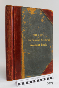
Financial record - Medical Accounts, c. 1929
... Victoria Park Recreation Reserve, on High Street, Koroit. John died... National School Number 618, on land that is now Victoria Park ...The accounts records in the Medical Accounts book start in February 1929 and refer to many of Warrnambool’s local names and addresses. The ledger book belonged to Dr John Hunter Henderson who conducted his medical practice from his home and surgery at Birchwood, 214 Koroit Street, Warrnambool, from 1904-1939. This particular accounts book spans from February 1929 to May 1931. Dr Henderson retired in 1939 and moved to Melbourne. His home, medical practice and many of his surgery’s items, including the Medical Accounts Book, were transferred to Dr William Roy Angus in that same year. The patients’ addresses on page 1 of the ledger include John Lee of St Marys Road, Wangoom. John Lee’s name has two entries on this page. He Grandfather, also John Lee, was a notable pioneer of the district. JOHN LEE John Lee was born in 1884 and died in 1948. His father (1845-1892) and grandfather (1814-1887) were also named John Lee. John Lee’s Grandfather, Grandmother, Father and Uncle arrived in Australia from Ireland in 1852. The colonial family settled in St Marys Road, Wangoom, Victoria and have a long association with the district. John Lee, born in 1814, is proudly listed amongst the names on the commemorative Warrnambool Pioneers Board, having arrived in Australia In 1852. In 1855 John’s Grandfather John Lee, aged 41, was head teacher of the Tower Hill School on the south bank of Tower Hill. Two years later, in 1857, the north bank of Tower Hill was surveyed and named the township of Koroit. In November of that year John Lee continued on as head master, now at the newly built Tower Hill Lake National School Number 618, on land that is now Victoria Park Recreation Reserve, on High Street, Koroit. John died in Warrnambool in 1887 but even 50 years later an ex-student wrote a letter to The Age newspaper, recalling memories of John Lee, his head master of the 1860s at the Tower Hill Lake Common School in Koroit. DR WILLIAM ROY ANGUS Doctor Angus had previously practiced in Nhill. The accounts book and many more items of Dr Angus were donated to Flagstaff Hill Maritime Village by the family of Dr Angus, Surgeon and Oculist. The Medical Accounts Book is part of the “W.R. Angus Collection” that includes historical medical equipment, surgical instruments and material once belonging to Dr Edward Ryan and Dr Thomas Francis Ryan, (both of Nhill, Victoria) as well as Dr Angus’ own belongings. The Collection’s history spans the medical practices of the two Doctors Ryan, from 1885-1926 plus that of Dr John Henderson from 1904+1939 and Dr Angus until he retired, from 1923 - 1969. The Medical Accounts Book is significant as a record of the names, addresses and health of the people in Warrnambool and District in the early 20th century. The Book is significant for its early 20th century association with two local doctors, Dr John Henderson and Doctor William Roy Angus, whose practices span from 1904-1969. The Book is also significant historically for its association with the ancestors of patient John Lee, whose Grandfather is recognised on the Warrnambool pioneer Board as one of the early pioneers in Victoria, arriving in 1852. Ledger, Medical Accounts Book. Title is Bruck’s Condensed Medical Account Book. Book has hardback, green cover, bound and reinforced with red leather and printed title in gold lettering. The pages of index tabs in the beginning of the book have no entries. The first page of the accounts section of the book have the hand written heading “February 1929”. The book continues until the end of May 1931. Inside both front and back cover are hand written notes in different scrips. Both black and blue ink has been used. The book belonged to Dr John Hunter Henderson. It is part of the W.R. Angus Collection."Bruck’s Condensed Medical Account Book"flagstaff hill, warrnambool, shipwrecked coast, flagstaff hill maritime museum, maritime museum, shipwreck coast, flagstaff hill maritime village, great ocean road, medical treatment, medical history, medical accounts, medical administration, medical record 1929, ledger, bruck’s condensed medical account book, john hunter henderson, william roy angus, edward ryan, thomas francis ryan, john lee, tower hill school, tower hill lake national school, koroit primary school, victoria school 628, st marys wangoom, warrnambool pioneer, birchwood, 214 koroit street warrnambool -
 Old Colonists' Association of Ballarat Inc.
Photograph - Image, The History of Charles Anderson and Charles Anderson Grove, Ballarat
... of Victoria Park (corner of Sturt and Gillies Street... was the North West portion of Victoria Park (corner of Sturt and Gillies ...Information relating to Charles Anderson and Charles Anderson Grove, Lake Gardens, Ballarat. The Old Colonists' Association Ballarat Inc. is a not for profit charitable organisation providing accommodation for elderly people. It manages a 27 Home retirement village at Charles Anderson Grove, Ballarat. Accommodation is offered at significantly below market rates. It has been providing low cost accommodation to the elderly since the 1920s. The Association Council overseas the running of this facility on a voluntary basis. HISTORY OF THE BALLARAT OLD COLONISTS' ASSOCIATION HOMES AT CHARLES ANDERSON GROVE, LAKE GARDENS One of the original objectives of the Association was “to provide the shelter of a house for those Pioneers of the Goldfields whom the reverses of fortune have deprived of the means of procuring the comforts of life in their declining years.” While the first home at Charles Anderson Grove was built in 1925 the Association had previously provided relief for needy pioneers from the time it was formed in 1883. Relief included monthly monetary payments, loads of firewood, medical assistance and distribution of Christmas boxes of groceries to deserving pensioners and in some cases payment of burial costs. Records indicate that in September 1922 three of the pensioners being assisted by the Association were accepted as residents in the newly erected Hassell Homes in Gillies Street (now demolished-opposite the High School). The first site for an Asylum for Indigent Members of the Old Colonists' Association was temporarily reserved from sale in October 1891. The site was approximately 28 acres in area in Mt Clear nearly opposite Midvale Shopping Centre in Main Road. The site was heavily timbered and when cleared over 260 tons of wood was sold to the Woah Hawp Gold Mining Company. A set of gates were erected but no homes built, although a plan for this reserve was drawn which showed twenty buildings ranging from one to four unit per building. The reserve was revoked in November 1909. The second site temporarily reserved in November 1909 as an Asylum was in Alfredton and consisted of some 7 acres and was adjacent to land reserved for an Abattoirs for the Ballarat Council. The reserve was revoked in February 1912 as it was deemed more appropriate to be added to the Abattoir site. Council suggested four (4) other sites in exchange for this land and they were inspected by the President, Vice President and Secretary on 22 December 1912. The first site inspected was land on the west side of Creswick Road opposite the brick kilns (now occupied by the showgrounds and oval). The land was described as being good quality, well fenced, no trees, good drainage and ample acreage but some distance from trams. The second site was Perry Park which was described as being good land, well fenced, having frontage to Gillies Street, good drainage and about 26 acres (but subsequently reduced to 10 acres). It was closely planted with Pinus Insignias and Wattle and had easy access from the Botanic Gardens tram. The third site was the North West portion of Victoria Park (corner of Sturt and Gillies Street) and was described as good land, well fenced and drained and well located. The fourth site was the South West corner of Victoria Park and known as Pound Paddock (corner of Winter Street and Gillies Street). It was considered to be low lying and too close to the Abattoir, and was also a considerable distance from trams. While the third site was recommended as the most suitable for the erection of homes it was considered unwise from the point of view as citizens to reduce the acreage of the park and therefore it was recommended that the Perry Park site be asked for as the most acceptable to the Association for the building of homes. The site was eventually temporarily reserved for an Asylum for Indigent Members of the Association in April 1914 with the gates from Mt Clear having been removed to the site a year earlier and eventually erected in 1917 for £12.10.0. In the same year the first 290 pine trees were advertised for removal in July and sold for £16. A sign indicating that the site was reserved for the erection of cottages was erected in September 1917. Stripping of the wattle bark (for tanning) and the cutting of the wood occurred in November 1918 with the land then being leased until it was required for the construction of the first homes in 1924. While the site was the third to be reserved it was the only one which was used for its intended purpose. It was named as Charles Anderson Grove in honour of Charles Anderson who joined the Association in 1918 and was President of the Association from 1942 to 1944. CHARLES HENRY GRATTAN ANDERSON C.H.G. Anderson (Electoral Returning Officer) was elected to membership of the Old Colonists' Association, Ballarat, in October 1918. He was elected to the Association Committee in 1926, and appointed Treasurer of the Association on the resignation of F. Ellis until the end of the financial year in 1933. In 1936 Charles Anderson indicated he would not be available for the President's Chair and that he would retire from the Committee owing to pressure of work. C.H.G. Anderson was welcomed as a new member of the Association in 1938, and served as President of the Old Colonists' Association from 1942-1944. Midway through 1949 Charles Anderson was appointed Members Secretary and Manager of the Ballarat Old Colonists' Club at £5.0.0 per week and 10/- for entertainment, to commence work prior to 01 August 1949. He was to do 30 hours per week and be present on Friday and generally on Saturday nights. In 1957 a minute of sympathy was extended to Club Manager Charles Anderson on the loss of his son. In 1958 a bonus of £20.0.0 was paid to Charles Anderson in recognition of his service in assisting the Secretary/Manager taking over under difficult conditions. In March 1964 the Shire of Ballarat would not permit a private road to be named Anderson Grove as Anderson Street already existed in Ballarat but Charles Anderson Grove was deemed acceptable. A recommendation of the Committee was put to the AGM in 1967 that Charles Anderson be made a Life Member. In 1969 an Association meeting observed a minutes silence in memory of Chas Anderson. Charles Anderson was also a Committee member of Ballarat Mechanics' Institute from February 1940 to February 1970. He was President in 1948. Black and white photographic portrait of Charles Anderson.charles anderson, charles anderson grove, ballarat old colonists' club, old colonists' association, ballarat, ballarat mechanics' institute, hassell homes, woah hawp gold mining company, firewood, retirement village -
 Eltham District Historical Society Inc
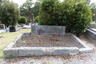
Photograph, Peter Pidgeon, Grave of Beulah Alice Rutter and children, June and Samuel, Eltham Cemetery, Victoria, 5 April 2021
... train at Victoria Park station. Sons David and Donald both... train at Victoria Park station. Sons David and Donald both ...Hubert and Beulah Alice (Simpson) Rutter had five children: Hubert Jnr. (Joe) in 1913, David in 1915, June in 1917, Donald in 1922 and Samuel in 1926. Samuel died as an infant aged 17 days. Hubert was a notable figure in Eltham and beyond, with a career as a mining manager in Australia and Malaya. He served in the AIF in the First World War. While the children were growing up at ‘Yarra Braes’, Eltham, their father was an Eltham Shire Councillor in the 1920s, shire president in 1928 and a leading figure in establishing the Shire of Eltham War Memorial League, which was responsible for building the Shire of Eltham War Memorial tower at Kangaroo Ground, near where the Shire Offices were located until the 1930s. The Rutter name was commemorated after the war at Eltham High School with one of the schoolhouses named ‘Rutter House’ and at Geelong Grammar School until the 1960s where a ‘Rutter Badge’ was awarded to junior boys for leadership. The family home, ‘Yarra Braes’ was destroyed in the devasting Black Friday bushfire, 13 January 1939 and Beulah relocated to Toorak, Hubert working in Western Australia. Tragedy struck the family again December 19, 1940 when daughter June was killed after falling from the Heidelberg train on to an adjacent track into the path of a Reservoir train at Victoria Park station. Sons David and Donald both served in the R.A.A.F. during the Second World War and were killed in action, David in Libya in 1941 and Donald in Germany in 1945. The wreck of his plane and his body were not recovered at the time and Hubert never ceased to chase down leads as to his whereabouts. Beulah never gave up hope that Donald was still alive. Hubert had received several reports shortly after the war that his son was still alive but these were ultimately accepted as misidentification. Such was the anguish of the grieving parents, their son’s plane not found to confirm the fact for certain. Hubert wrote to the Air Force in frustration, failing to understand how the plane could disappear when it crashed in a relatively populated area. Unfortunately the answers came too late for Beulah who died in 1946 and was buried in Eltham Cemetery along with her daughter June and baby Samuel. Donald’s plane was eventually located and his body recovered in 1949. He is buried in the Hanover War Cemetery, Germany. David is commemorated on Column 245, Alamein Memorial, Egypt. Both David and Donald are commemorated on Eltham’s Roll of Honour Board, commissioned by the Eltham War Memorial Trust to be hung in the Baby Health Centre, part of the Eltham War Memorial building precinct. Hubert Senior and Hubert Junior both continued to work in the mining industry in Western Australia. Hubert senior died 1957 at Plantagenet Western Australia and Hubert junior in 1979 at Gascoyne, Western Australia. Sacred to the memory of Beulah AliceBeloved wife of Hubert Rutter Died August 21st 1946 also June Beloved daughter of Beulah and Hubert Rutter Died 19th December 1940 aged 23 years Also her baby brother Samuel Died 7th October 1926, aged 17 daysBorn Digitaleltham cemetery, gravestones, beulah alice rutter, hubert rutter, june rutter, samuel rutter -
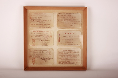 Wangaratta RSL Sub Branch
Postcard - Framed POW Postcards, Private S Chandler, c1940
... at Royal Park in Victoria. Chandler served with the 2/2nd Pioneer.../1941 at Royal Park in Victoria. Chandler served with the 2/2nd ...Six POW postcards sent by Private Stanley Pascoe CHANDLER VX57554 to his mother Christina Chandler in Wahgunyah Victoria. Chandler was born in Wahgunyah and enlisted on the 11/6/1941 at Royal Park in Victoria. Chandler served with the 2/2nd Pioneer Battalion and was reported missing in Java in April 1942 during WW2. He was discharged on the 15/1/1946 The post cards were printed by the Imperial Japanese Army for POW's to send home that describes the good climate, food, medicine and clothes. They also allow room for a brief message. Chandler wrote that he was interred with his friend Frank Allen, received 10 cents per day and has not had any illness. POWs were supposed to be able to communicate with their family at home through the International Red Cross under certain conditions. For example, they were limited to 100 letters. However, in reality it was impossible for them to communicate with family more than once or twice during the duration of imprisonment, and there were camps where the POWs were not allowed to communicate with the world outside the camp at all. The average number of cards which the Japanese allowed to be sent out was from four to five for the whole period of captivity, and only some of these reached their destinations.Timber frame containing six POW postcards mounted on cardboard. Postcards printed by Imperial Japanese Army for POW's to send to families, describing their health and living conditions.Postcards have messages home, "Dear Mother, prisoner of war, unwounded and well. Hope all well at home. Love and kisses Stan".pow, world war 2, burma, wahgunyah victoria, prisoner of war, stanley pascoe chandler -
 Parks Victoria - Gabo Island Lightstation
Locker, flag
... utilitarian furnishings in the six lightstations Parks Victoria...Parks Victoria - Gabo Island Lightstation Gabo Island ...Probably used in the past to house the Signal Flag set at the lightstation. Appears to have been stored in the old stables for a number of years.The rectangular wooden cabinet has the distinctive features of a flag locker, comprising numerous open compartments of the same size each for storing a signal flag of a unique design. It has three internal shelves and a bench top, and is painted grey, a colour that is used for many of the wooden utilitarian furnishings in the six lightstations Parks Victoria manages. The cabinet, without its flag contents, was found in storage in the old stone stable building and is highly likely to be original to the lightstation. A wooden flag locker is held at Wilsons Promontory Lightstation. A wooden locker comprising two sections of 16 pigeon holes and four cupboard doors is held at Cape Otway The two flag lockers at Cape Nelson Lightstation are included in Victorian Heritage Register for contributing to the significance of the lightstation. The Nelson, Otway and Promontory lockers have associated sets of flags which are original to the lightstations. The Gabo Island cabinet has second level contributory significance for its provenance to the lightstation.Timber cabinet painted grey, partitioned with numerous open compartments of the same size . -
 Eltham District Historical Society Inc
Photograph, Fay Bridge, Ancient Eel trap on the Yarra River at Laughing Waters, Eltham - pre-dating European settlement, 6 September 2023
... managed by Parks Victoria. The Narrap team in partnership... managed by Parks Victoria. The Narrap team in partnership ...Laughing Waters is the name for a stretch of the Yarra Valley Parklands consisting of river flats and hilly riparian bushland. With Birrarung (Yarra River) flowing through, Laughing Waters has been an important gathering place for thousands of years. For the Wurundjeri, ‘Garambi Baan’ (the name for Laughing Waters in Woi wurrung) is an important site for growing and harvesting food. Significantly, Wurundjeri iuk (eel) traps remain at Garambi Baan to this day. The Wurundjeri Woi Wurrung People take their name from the Woi wurrung language word ‘wurun’ meaning the Manna Gum (Eucalyptus viminalis) which is common along ‘Birrarung’ (Yarra River), and ‘djeri’, the grub which is found in or near the tree. Wurundjeri are the ‘Manna Gum People’ and their Ancestors have lived on this land for millennia. The site on the Yarra River near the former Morrison property Killeavey was given a language name in 2015 at the instigation of Wurundjeri Elder, Dave Wandin. Garambi Baan means “laughing waters” in the traditional language, Woi wurrung. The site at Warrandyte was rediscovered by Campbell Beardsell OAM in 2007 and is one of only a few known remaining iuk (eel) traps on Country once found the length of the Birrarung (Yarra) and the Maribyrnong. Original Indigenous aquacultural infrastructure was dismantled, taken away from sites and used to build houses, fords and roads by Europeans. The difficult and restricted access to this site is thought to be one of the reasons for its survival. The iuk trap is located within lands managed by Parks Victoria. The Narrap team in partnership with Parks Victoria and Acacia Land Management have been improving the native vegetation with a program of woody weed removal, exclusion fencing and revegetation. Importantly, the team have restored the trap’s infrastructure and have demonstrated its effectiveness.” References: Wurundjeri Woi Wurrung Cultural Heritage Aboriginal Corporation - Laughing Waters. (2023, September 3). Retrieved from https://inplace.org.au/laughing-waters/ GARAMBI BAAN LAUGHING WATERS RESIDENCY CENTRE 2020 2024 Strategic Plan, Nillumbik Shire Council (2023, September 3). Retrieved from https://www.nillumbik.vic.gov.au/files/assets/public/minutes-and-agendas/2020/09-sep/15-sep-cm/ocm.177-20-attachment-1-laughing-waters-arts-program_1.pdffay bridge collection, eel trap, laughing waters, yarra river, wurundjeri woi wurrung, garambi baan, 2023-09-06 -
 Eltham District Historical Society Inc
Photograph, Fay Bridge, Ancient Eel trap on the Yarra River at Laughing Waters, Eltham - pre-dating European settlement, 16 May 2015
... managed by Parks Victoria. The Narrap team in partnership... managed by Parks Victoria. The Narrap team in partnership ...Laughing Waters is the name for a stretch of the Yarra Valley Parklands consisting of river flats and hilly riparian bushland. With Birrarung (Yarra River) flowing through, Laughing Waters has been an important gathering place for thousands of years. For the Wurundjeri, ‘Garambi Baan’ (the name for Laughing Waters in Woi wurrung) is an important site for growing and harvesting food. Significantly, Wurundjeri iuk (eel) traps remain at Garambi Baan to this day. The Wurundjeri Woi Wurrung People take their name from the Woi wurrung language word ‘wurun’ meaning the Manna Gum (Eucalyptus viminalis) which is common along ‘Birrarung’ (Yarra River), and ‘djeri’, the grub which is found in or near the tree. Wurundjeri are the ‘Manna Gum People’ and their Ancestors have lived on this land for millennia. The site on the Yarra River near the former Morrison property Killeavey was given a language name in 2015 at the instigation of Wurundjeri Elder, Dave Wandin. Garambi Baan means “laughing waters” in the traditional language, Woi wurrung. The site at Warrandyte was rediscovered by Campbell Beardsell OAM in 2007 and is one of only a few known remaining iuk (eel) traps on Country once found the length of the Birrarung (Yarra) and the Maribyrnong. Original Indigenous aquacultural infrastructure was dismantled, taken away from sites and used to build houses, fords and roads by Europeans. The difficult and restricted access to this site is thought to be one of the reasons for its survival. The iuk trap is located within lands managed by Parks Victoria. The Narrap team in partnership with Parks Victoria and Acacia Land Management have been improving the native vegetation with a program of woody weed removal, exclusion fencing and revegetation. Importantly, the team have restored the trap’s infrastructure and have demonstrated its effectiveness.” References: Wurundjeri Woi Wurrung Cultural Heritage Aboriginal Corporation - Laughing Waters. (2023, September 3). Retrieved from https://inplace.org.au/laughing-waters/ GARAMBI BAAN LAUGHING WATERS RESIDENCY CENTRE 2020 2024 Strategic Plan, Nillumbik Shire Council (2023, September 3). Retrieved from https://www.nillumbik.vic.gov.au/files/assets/public/minutes-and-agendas/2020/09-sep/15-sep-cm/ocm.177-20-attachment-1-laughing-waters-arts-program_1.pdffay bridge collection, 2015-05-16, eel trap, laughing waters, yarra river, wurundjeri woi wurrung, garambi baan