Showing 4280 items matching " prior"
-
 Kiewa Valley Historical Society
11 Black and White photographs of the Rocky Valley area, c1948
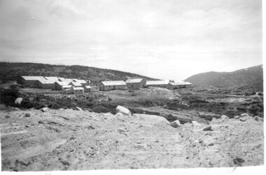
In October 1947 construction was commenced on the erection of the workmen's camp at Rocky Valley. Also in 1947 construction of a stream diversion was commenced to allow excavation to commence for the dam wall. In the summer of 1948/49, stripping of the foundation area on both sides of the river was carried out. Weather conditions were not always favourable during the construction, particularly 1955/56 summer, and work would have to cease each year for the winter season due to the severe conditions. The dam is a earth and rock fill structure with a height of about 30.5 metres and crest length 518.16 metres and was completed in March, 1959.These photographs show the type of terrain in the area prior to the construction and filling of Rocky Valley Dam. Also of interest is the type of accommodation provided for those working on the construction and the early cranes available in the 1940/50's. Of historical importance to understand the conditions in the early construction of the Kiewa Hydro Electric SchemeEleven small black and white photographsPhoto No. 1 - on the back, printed in ink"Rocky Valley - New Mess & offices Dec. 1948". In pencil '14 on the back Photo No. 2 - on the back, printed in ink "Rocky Valley Camp. October 1948". Also stamped on the back "998L" Photo No. 3 -on the back, printed in ink "Rocky Valley Hostel October 1948". Also stamped on the back '998L' Photo No. 4 - on the back, printed in ink "Spion Kopje from bedroom window. October 1948". Stamped on the back '998L'. Photo No. 5 - on the back, printed in ink "Rocky Valley Basin Dec. 1948." In pencil on back, 14. Photo No. 6 - on the back, printed in ink "Site of Wall for Rocky Valley Dam Dec. 1948". In pencil on back, 14. Photo No. 7 - On the back, printed in ink "Commencing of Diversion Tunnel Rocky Valley December 1948". In pencil on back, 14. Photo No. 8 - on the back, printed in ink "One of the two electric cranes at Rocky Valley December 1948". In pencil on back, 14. Photo No. 9 - on the back, printed in ink "'Rapier' (H.Y.) electric crane Rocky Valley December 1948". In pencil on back, 14 . Photo No. 10 - on the back, printed in ink " Pretty Valley Pump line construction Mt. Cope in Background Nov 1948. Circular stamp with the words 'print by Wilson White Albury' in the circle. Photo No. 11 - on the back, printed in ink "Stringing cable on Ruined Castle October 1948. Same stamp as No. 10. In pencil '31'. rocky valley; pretty valley; ruined castle; bogong high plains; kiewa hydro electric scheme -
 Kiewa Valley Historical Society
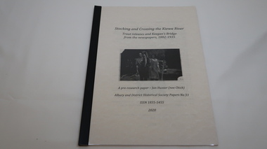
Book - Kiewa River, Stocking and Crossing the Kiewa River by Jan Hunter (nee Chick), 2020
The Chick brothers, Alf, Les and Allan, plus friends, began trout fishing and camping in the Kiewa Valley before the early 1930s. Les continued his connection with the Kiewa River until his death in 1972. Fingerlings were placed in the Kiewa River from the early 1880s. Keegan's Bridge is a crossing near Upper Gundowring and about 4 km south east of Dederang. References to the crossing were made in the early 1900s and a petition presented to Council in 1904 calling for a bridge.The bridge was built and opened in 1907. The photos are of the release of fingerling trout in the Kiewa River, thought to be at Keegan's Bridge. The fingerlings were transported in drums on the back of trucks. The photos are c1940s.The Kiewa Valley has been a popular spot for fishermen, tourists and campers from the 1880s. One of the many attractions has been the excellent fishing along the Kiewa River due to the regular release of fish especially brown trout. This continues to the present day (2020) when a few fish were marked with $$ signs for the lucky fisherman who caught them. This attracts visitors, their families and boosts the economy and dates back to visits at the Tawonga Pub prior to the Kiewa Hydro Electric Scheme.19 page book with black plastic spine and clear plastic cover over the beige paper cover with title , author and black & white photo. Note: In KVHS photo collection there are 4 good quality reproduction photos on photographic paper. These have been produced professionally. These photos of Jan Hunter's are featured on the second page of her book. These also have a letter attached. The book is a pre-research paper & is No 33 of the Albury and District Historical Society Papers. The sub-title is "Trout releases and Keegan's Bridge / from the newpapers, 1882-1935"None on the book but a letter is attached from Jan Hunter, the author as a follow up to the photos she donated. On the photos - On the back: Fujifilm / Fujicolor Crystal Archive / Paper / Production - run codekiewa river; trout; fish; keegan's crossing; keegan's bridge; fingerlings; chick family; camping; tourism -
 Kiewa Valley Historical Society
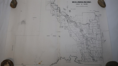
Map - Mullindolingong
Land owners of land in the Kiewa Valley in 1928The Kiewa Valley was farming country with families settling in the area prior to 1928 Two sheets the same: (one old with paper joined together and the other is a copy without any joins. 21 6 1928 dated Map of Mullindolingong / County of Bogong showing land owners along the Kiewa River and beyond.Produced by the Department of Lands and Survey, Melbournemullindolingong, kiewa valley, land owners, families of the kiewa valley -
 Kiewa Valley Historical Society
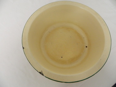
Basin - Enamel
Enamel basins were used usually for washing hands and face at home and in hospitals. Water was heated and added to the cold water in the basin. Water was heated on the stove and then mixed with cold water for washing people prior to hot and cold water being available by taps. This basin may have been used at home or at the Tawonga District Hospital in the Kiewa Valley.Large round pale yellow enamel basin with green rounded edge. It has straight slightly sloping sides with a rim.enamel basin. washing. hospitals. hygiene. -
 Kiewa Valley Historical Society
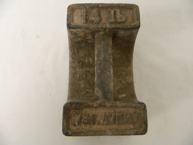
Weights
Weight was used on platform type scale to weigh farm produceImperial weights were used prior to 1966 when decimal currency was introduced. Weights were used in stores selling farm produce prior to packaging.Cast iron weight with a solid base the upper side curved to form two ends which are joined by a cylindrical handle. The ends are embossed on the top.W & T Avery 14 lbweights. scale. farms produce. w & t avery. -
 Kiewa Valley Historical Society
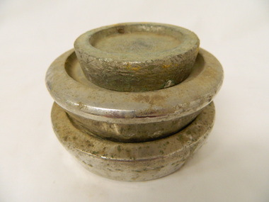
Weights - 3 in Set
Used to weigh goods in a shop or farming produce store.Imperial weights were used prior to decimalisation. Weights were used to weigh goods prior to packaging.Cast iron solid circular weights with rim around circumference and slightly narrower at the base.Largest - 4 lb Middle - 4 lb (None on smallest)weights. shop. store. scale. -
 Kiewa Valley Historical Society
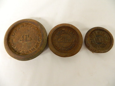
Weights - 3 in Set
These weights were used to measure goods in a shop or farm produce store.Historical: These weights were used prior to decimalisation and prior to packaging of goods.Solid cast iron brown weights with rim around the circumference. Embossed inside the rim at the top with the maker and weight. Slightly narrower at the base.4 lb / Crane F Co. / Wolverhampton 2 lbs / Imperial / Standard 1 lb / Imperial / Standardweights. store. shop. scales. -
 Kiewa Valley Historical Society
Switchboard - S.E.C.V
The switchboard was located in the office of the switchyard. This switchboard was used by the State Electricity Commission of Victoria on the Kiewa Hydro Electric Scheme in Mt Beauty. Employees living in the towns and in the Kiewa Valley who had telephones were connected to the switchboard and were able to speak after dialling a number and then being connected by an operator working at the switchboard. This connection pre dated automatic connections. This switchboard was used by the S.E.C.V. for their employees on the Kiewa Hydro Electric Scheme and is an example of communications used in the 1940s and 1950s using telephones and operators prior to automatic 'stations'. To prevent operators from listening to conversations, a tone was introduced so that those on the phone became aware of someone listening in to their conversation.switchboard. mt beauty. state electricity commission of victoria. kiewa hydro electric scheme. telephones. communication. -
 Warrnambool and District Historical Society Inc.
Document, Map: Lady Bay 1853, 1853
This is one of the earliest surveys and maps of Warrnambool harbor, Lady Bay. Being done in 1853, it shows the depths of the bay area marked in fathoms, currents and directions and areas of rocks around mouth of the Merri and the Western side of the bay as well as a large sand spit to the middle right of the beach region.. It also marks the large areas of seaweed and fuci in the outer bay area. It has the area of Pertobe Lagoon marked and shows the early tracks to the town. The engraving work was done by Tulloch and Brown, with Tulloch being one of the earliest engravers and lithographers in the state of Victoria. He arrived in Melbourne in 1849 and set up business with James Davie Brown in 1853 with Brown being a map engraver. They were awarded bronze and silver medals for their work at the Victorian Industrial Exhibition. He also worked in the vignettes on the Proeschel Map of Victoria.This map is of high historical and comparitive significance as it shows the Lady Bay area prior to the changes that have occurred in the last 160 years with the building of the breakwater. The issue regarding access to Lady Bay remains a current one. The engraver D Tulloch engraved some of the earliest scenes of the goldfields in Ballarat and as such has left a record of a very early and important era in Australian history. Rectangular cream paper with black text. Map area is outlined by fine black lined border. Key in top right hand corner and scale at bottom middle of map.Map is labelled Town of Warrnambool printed at top of map. Small logo at top right corner which has “Hydrographic Department” in circle around an anchor. Lady Bay Warrnambool Surveyed by John Barrow assistant surveyor Engraved by Tulloch & Brown in bottom right corner. Melbourne engraved by order of the legislative Council of Victoria in middle bottom.map, warrnambool, town of warrnambool map 1853, tulloch & brown map 1853, lady bay warrnambool,, warrnambool harbour, warrnambool breakwater, warrnambool beach -
 Warrnambool and District Historical Society Inc.
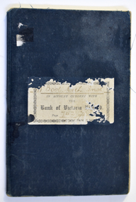
Financial record (Item) - Warrnambool Mechanics Institute & Free Library Bank of Victoria Bank Book, The Bank of Victoria Limited Warrnambool, 1904-1911
The Bank of Victoria was located at 7a Liebig Street, Warrnambool. The building still exists in 2023 as a part of the Quest apartments. The Warrnambool Mechanics' Institute was formed in 1859 and the first reading room opened in 1884. Responsibility for all activities of the Warrnambool Mechanics' Institute activities were formally handed over to the Warrnambool city Council on 27th July 1911. This Bank of Victoria Limited passbook documents credits and debits of the Warrnambool Mechanics' Institute & Free Library from December 1904 until 30th June 1911 just prior to the transfer to the Warrnambool City Council. This passbook is an example of how banking records were kept in the early 20th century. W'Bool. Mech. Inst. in Account with the Bank of Victoria Limited. Page 742 783warrnambool mechanics’ institute library, bank of victoria, warrnambool -
 Warrnambool and District Historical Society Inc.
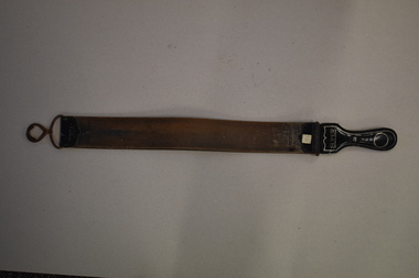
Shaving strop
This shaving strop is typical of those used in barbers shops. It was used to sharpen the edge of a straight blade razor.This item is of social and historical interest and belonged mainly to the era prior to the invention of safety blades and electric razors.Light brown double leather strop with black leather handle at one end and metal hook at the other end. There is text on both ends of the strap and the handle.On handle Super 99."Sharpen" on strap section with carborundum at the other end. On the reverse: genuine horse hide Finish . shaving strop, barber's strop, warrnambool -
 Warrnambool and District Historical Society Inc.
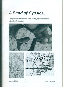
Booklet, A band of gypsies: employees of Niel Black & Co in the pre-goldrush era: a work in progress
Niel Black was an early settler in the Western District of Victoria who held large tracts of land including Glenormiston and The Sisters estates. Black was responsible for bringing many employees to the area. The employees' names, birthplace, arrival date, marriage partner/s, other employers are tabulated. An overview of Black's properties and conditions of the time is also included.This booklet documents those who came to the Western District to work for Niel Black prior to the goldfishes of the 1850s.In-house booklet with plastic sleeve outer cover, with black & white images of sheep shears, wool and a map of the Black property. All text is in black.emigration, employment, family history, early victorian squatters -
 Eltham District Historical Society Inc
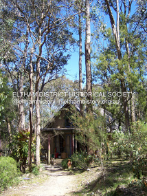
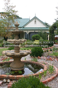
Photograph - Digital Photograph, Marguerite Marshall, Neil Douglas house, Bend Of Islands, 3 October 2006
Mud brick house first owned by naturalist and artist Neil Douglas and Helen (Abbie) Heathcote at the Bend of Islands. They were original residents in the 1970s. This house is on the Victorian Heritage Database and is considered locally significant. Covered under Heritage Overlay, Nillumbik Planning Scheme Published: Nillumbik Now and Then / Marguerite Marshall 2008; photographs Alan King with Marguerite Marshall.; CoverThis collection of almost 130 photos about places and people within the Shire of Nillumbik, an urban and rural municipality in Melbourne's north, contributes to an understanding of the history of the Shire. Published in 2008 immediately prior to the Black Saturday bushfires of February 7, 2009, it documents sites that were impacted, and in some cases destroyed by the fires. It includes photographs taken especially for the publication, creating a unique time capsule representing the Shire in the early 21st century. It remains the most recent comprehenesive publication devoted to the Shire's history connecting local residents to the past. nillumbik now and then (marshall-king) collection, bend of islands, neil douglas house, neil douglas -
 Eltham District Historical Society Inc
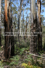
Photograph - Digital Photograph, Alan King, Manna Gums at the Gawa Wurundjeri Aboriginal Resource Trail, 28 December 2007
Manna Gum is a species of a small to a very tall tree that is endemic to south-eastern Australia. These particular trees are part of the Gawa Wurundjeri Resource Trail at Watsons Creek. Signs share information about how the Wurundjeri people lived near the creek and used the land to obtain bush foods, medicines, tools, shelter and clothes. The trail introduces visitors to the indigenous flora and fauna, including manna gums, Lomandra (used to weave baskets) and wombat burrows. Published: Nillumbik Now and Then / Marguerite Marshall 2008; photographs Alan King with Marguerite Marshall.; p3This collection of almost 130 photos about places and people within the Shire of Nillumbik, an urban and rural municipality in Melbourne's north, contributes to an understanding of the history of the Shire. Published in 2008 immediately prior to the Black Saturday bushfires of February 7, 2009, it documents sites that were impacted, and in some cases destroyed by the fires. It includes photographs taken especially for the publication, creating a unique time capsule representing the Shire in the early 21st century. It remains the most recent comprehenesive publication devoted to the Shire's history connecting local residents to the past. nillumbik now and then (marshall-king) collection, gawa wurundjeri aboriginal resource trail, manna gums, watsons creek -
 Eltham District Historical Society Inc
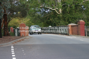
Photograph - Digital Photograph, Alan King, The Diamond Creek Bridge, 30 March 2008
Old Bridge on Main Hurstbridge road in Diamond Creek township crossing the Diamond Creek. The bridge opened in April 1898. Evelyn Observer, and South and East Bourke Record (Vic. : 1882 - 1902), Friday 22 April 1898, page 2 "Diamond Creek Bridge. The official opening of this bridge took place yesterday (Thursday) in the presence of a large gathering of people. The bridge-a substantial iron structure, costing .~r 2oo-was profusely decorated with "flags of all nations" for the occasion. In the absence of the Minister' of Public Works-who was unavoidably prevented from attending-the opening ceremony was neatly performed by President Lugton, of the Heidelberg Shire, in a few wellchosen words, after which an adjournment was made to the Literary Institute, where some sixty gentlemen were entertained at luncheon, followed by speeches, songs, and recitations. It was a red letter day for the Creek, and everything passed off with becoming eclat." Published: Nillumbik Now and Then / Marguerite Marshall 2008; photographs Alan King with Marguerite Marshall.; p7This collection of almost 130 photos about places and people within the Shire of Nillumbik, an urban and rural municipality in Melbourne's north, contributes to an understanding of the history of the Shire. Published in 2008 immediately prior to the Black Saturday bushfires of February 7, 2009, it documents sites that were impacted, and in some cases destroyed by the fires. It includes photographs taken especially for the publication, creating a unique time capsule representing the Shire in the early 21st century. It remains the most recent comprehenesive publication devoted to the Shire's history connecting local residents to the past. nillumbik now and then (marshall-king) collection, diamond creek, diamond creek bridge, main hurstbridge road -
 Eltham District Historical Society Inc
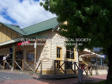
Photograph - Digital Photograph, Marguerite Marshall, Post Office, Hurstbridge, 27 September 2007
The Post Office building was built in 1918 by printer, Robert Charles Harris, owner of The Evelyn Observer newspaper. In 2007 a Post Office, cafe and giftshop operated from here. Covered under Heritage Overlay, Nillumbik Planning Scheme. Published: Nillumbik Now and Then / Marguerite Marshall 2008; photographs Alan King with Marguerite Marshall.; p13This collection of almost 130 photos about places and people within the Shire of Nillumbik, an urban and rural municipality in Melbourne's north, contributes to an understanding of the history of the Shire. Published in 2008 immediately prior to the Black Saturday bushfires of February 7, 2009, it documents sites that were impacted, and in some cases destroyed by the fires. It includes photographs taken especially for the publication, creating a unique time capsule representing the Shire in the early 21st century. It remains the most recent comprehenesive publication devoted to the Shire's history connecting local residents to the past. nillumbik now and then (marshall-king) collection, hurstbridge, post office, post office cafe -
 Eltham District Historical Society Inc
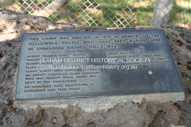
Photograph - Digital Photograph, Alan King, Plaque by the Hurst family cemetery, 1 February 2008
Plaque placed at a cairn erected in 1975 at the Hurst family cemetery at Hurstbridge in memory of people who were buried locally in unmarked graves. Transcription of plaque: This cairn was ereced in 1975 in memory of the following people who have been buried here in unmarked graves since 1866. Robert Thomas Hurst (father) Frances Facey Gurst (mother) Robert Hurst Ellen Hurst (Mrs Spencer) Fanny Hurst (Mrs Hawkins) Mr. Abbot-Christian name unknown Who was present when Henry was shot by the bushranger. An unnamed babe belonging to Catherine and Fred Hurst Ashes scatterd: Catherine Hurst (Fred's wife) Frances Ellen Hurst (Mrs Gray) William George Gray Published: Nillumbik Now and Then / Marguerite Marshall 2008; photographs Alan King with Marguerite Marshall.; p15This collection of almost 130 photos about places and people within the Shire of Nillumbik, an urban and rural municipality in Melbourne's north, contributes to an understanding of the history of the Shire. Published in 2008 immediately prior to the Black Saturday bushfires of February 7, 2009, it documents sites that were impacted, and in some cases destroyed by the fires. It includes photographs taken especially for the publication, creating a unique time capsule representing the Shire in the early 21st century. It remains the most recent comprehenesive publication devoted to the Shire's history connecting local residents to the past. nillumbik now and then (marshall-king) collection, hurst family cemetery, hurstbridge, memorial -
 Eltham District Historical Society Inc
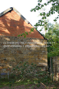
Photograph - Digital Photograph, Alan King, The barn at Culla Hill, Sweeneys Lane, Eltham, 30 January 2008
The barn of former convict Thomas Sweeney at Culla Hill remains almost in its original condition. Published: Nillumbik Now and Then / Marguerite Marshall 2008; photographs Alan King with Marguerite Marshall.; p19This collection of almost 130 photos about places and people within the Shire of Nillumbik, an urban and rural municipality in Melbourne's north, contributes to an understanding of the history of the Shire. Published in 2008 immediately prior to the Black Saturday bushfires of February 7, 2009, it documents sites that were impacted, and in some cases destroyed by the fires. It includes photographs taken especially for the publication, creating a unique time capsule representing the Shire in the early 21st century. It remains the most recent comprehenesive publication devoted to the Shire's history connecting local residents to the past. nillumbik now and then (marshall-king) collection, culla hill, eltham, sweeney's cottage, sweeneys lane -
 Eltham District Historical Society Inc
Photograph - Digital Photograph, Alan King, Pigeon Bank, one of the Nillumbik shire's oldest farm dwellings, 6 February 2008
In 1848, Francis Rogerson form Dumfriesshire, Scotland purchased 80 acres of land at Kangaroo Ground on which he built a two-roomed bark hut. He named the property afterr the many Bronzewings and Wonga Pigeons in the area. Ewen Hugh Cameron moved to Pigeon Bank the same year he was elected to Parliament as the Member for Evelyn. At the time he moved in, Pigeon Bank had six rooms and the present water well. He made further extensive additions and lived there until his death in 1915. Covered under Heritage Overlay, Nillumbik Planning Scheme. Published: Nillumbik Now and Then / Marguerite Marshall 2008; photographs Alan King with Marguerite Marshall.; p27This collection of almost 130 photos about places and people within the Shire of Nillumbik, an urban and rural municipality in Melbourne's north, contributes to an understanding of the history of the Shire. Published in 2008 immediately prior to the Black Saturday bushfires of February 7, 2009, it documents sites that were impacted, and in some cases destroyed by the fires. It includes photographs taken especially for the publication, creating a unique time capsule representing the Shire in the early 21st century. It remains the most recent comprehenesive publication devoted to the Shire's history connecting local residents to the past. nillumbik now and then (marshall-king) collection, ewen hugh cameron, francis rogerson, kangaroo ground, kangaroo ground-warrandyte road, pigeon bank -
 Eltham District Historical Society Inc
Photograph - Digital Photograph, Alan King, Original Kangaroo Ground Primary School No. 2105 building, Eltham-Yarra Glen Road, Kangaroo Ground, 28 December 2007
Kangaroo Ground's first school began in 1851 with 22 pupils from the district's ten families. It was a single room school located further south on the site, which also served as a Presbyterian church. The first teacher was Andrew Ross. The school building was used as a Post Office between 1854 and 1858 and during 1857 also served as a Court of Petty Sessions. With a growing farming community, a new building was warranted and the original Sate School No. 352 was closed and a new building, State School No. 2105 was oipened October 1, 1878. A residence for Head Teacher Henry Wallace School was erected in 1879 attached to the left of the school building. That residence is now home to the Andrew Ross Museum, which opened in 1993. Covered under Heritage Overlay, Nillumbik Planning Scheme. Published: Nillumbik Now and Then / Marguerite Marshall 2008; photographs Alan King with Marguerite Marshall.; p35This collection of almost 130 photos about places and people within the Shire of Nillumbik, an urban and rural municipality in Melbourne's north, contributes to an understanding of the history of the Shire. Published in 2008 immediately prior to the Black Saturday bushfires of February 7, 2009, it documents sites that were impacted, and in some cases destroyed by the fires. It includes photographs taken especially for the publication, creating a unique time capsule representing the Shire in the early 21st century. It remains the most recent comprehenesive publication devoted to the Shire's history connecting local residents to the past. nillumbik now and then (marshall-king) collection, kangaroo ground, eltham-yarra glen road, kangaroo ground primary school no. 2105, kangaroo ground state school, state school no. 2105 -
 Eltham District Historical Society Inc
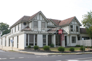
Photograph - Digital Photograph, Alan King, Eltham Hotel, cnr Main Road and Pitt Street, 28 December 2007
The Eltham Hotel is the oldest continually operating hotel in the Eltham district. Initially referred to as the Little Eltham Hotel, it has been known as the Eltham Hotel since the mid-1850s through to the present except for a brief period as the Eltham Tavern in the late 1980s. The original hotel opened in 1854 by Richard Warren was built by Benjamin Oliver Wallis. The Fountain of Friendship Hotel on the opposite side of Maria Street (Main Road) opened shortly after. The hotel was a well-known resting place for gold diggers during the gold rush at Woods’ Point and Warren would buy the gold from the diggers. Warren ran into financial difficulties and determined to return to England. Wallis bought the hotel in 1861 and ran it till 1886 when he sold it to Christopher Watson Snr. When Christopher Watson Snr died a year after purchase, his son Christopher took over until his death in 1909 when it passed to wife Emily and then their youngest son, Herbert James (Jim) Watson in 1915. In July 1925, Jim Watson demolished the original building and, in its place, erected a modern hotel which remains the foundation of the present-day Eltham Hotel. Covered under Heritage Overlay, Nillumbik Planning Scheme. Published: Nillumbik Now and Then / Marguerite Marshall 2008; photographs Alan King with Marguerite Marshall.; p41This collection of almost 130 photos about places and people within the Shire of Nillumbik, an urban and rural municipality in Melbourne's north, contributes to an understanding of the history of the Shire. Published in 2008 immediately prior to the Black Saturday bushfires of February 7, 2009, it documents sites that were impacted, and in some cases destroyed by the fires. It includes photographs taken especially for the publication, creating a unique time capsule representing the Shire in the early 21st century. It remains the most recent comprehenesive publication devoted to the Shire's history connecting local residents to the past. nillumbik now and then (marshall-king) collection, eltham, eltham hotel, main road, pitt street -
 Eltham District Historical Society Inc
Photograph - Digital Photograph, Alan King, Jarrold Cottage, 701 Main Road, Eltham, 29 January 2008
Jarrold Cottage or White Cloud is known by many to be associated with the Skipper family, and has been since 1944 when Lena Skipper, wife of Mervyn Skipper purchased the cottage. She purchased it from the Estate of Thekla Jarrold who had died in March of the previous year. By the time Thekla died, she had lived in the Jarrold Cottage for 50 years. Thekla Alvenia Sissilia Ellian married John William Jarrold in 1888 at Clifton Hill. They started their family there but when John’s father William (who was married to Hannah Coleman) died in 1893 the family moved to Eltham. William had married Hannah Coleman in 1856 at his home in Eltham. William had arrived in the colony in 1848 so it is believed the Jarrold Cottage goes back at least to 1856 and possibly early 1850s. For a short period of time the cottage was rented to the Police as a temporary Police Station whilst a new and more permanent station was built further up the hill in 1859. The cottage was originally located closer to the Diamond Creek but was subject to flooding so was relocated to its present position on top a mound of rubble placed there from the nearby quarry next to the Dalton Street school (on Main Road). By 1916, John Henry Clark, a photographer who took many early photos of Eltham relocated from Fitzroy to Eltham and boarded with recently widowed Thekla Jarrold and her family. He changed professions from photographer to boot and harness maker around 1931 and Thekla had a small bootmakers shop built ifor him in the corner of her property next to the family home. J.H. Clark remained living at the property until his death in December 1956. At some stage after Clark's death, Lena Skipper is recorded living at the property having relocated from Montsalvat following the death of her husband Mervyn. The property continues to remain within the Skipper family as of 2023. Covered under Heritage Overlay, Nillumbik Planning Scheme. Published: Nillumbik Now and Then / Marguerite Marshall 2008; photographs Alan King with Marguerite Marshall.; p47This collection of almost 130 photos about places and people within the Shire of Nillumbik, an urban and rural municipality in Melbourne's north, contributes to an understanding of the history of the Shire. Published in 2008 immediately prior to the Black Saturday bushfires of February 7, 2009, it documents sites that were impacted, and in some cases destroyed by the fires. It includes photographs taken especially for the publication, creating a unique time capsule representing the Shire in the early 21st century. It remains the most recent comprehenesive publication devoted to the Shire's history connecting local residents to the past. nillumbik now and then (marshall-king) collection, bootmaker's shop, hannah coleman, jarrold cottage, john henry clark, john william jarrold, lena skipper, police station, thekla alvenia sissilia jarrold (nee ellian), white cloud cottage, william jarrold -
 Eltham District Historical Society Inc
Photograph - Digital Photograph, Alan King, Former bootmaker's shop, Main Road Eltham, 29 January 2008
The former bootmaker's shop is one of only three remaining original shops from the early 20th century in what was once Little Eltham, the others being the present day Cafe Zen-Den at 736 Main Road and the former Burgoyne General Store and Post Office, present-day San Antonio Barbershop at 820 Main Road. Jarrold Cottage or White Cloud is known by many to be associated with the Skipper family, and has been since 1944 when Lena Skipper, wife of Mervyn Skipper purchased the cottage. She purchased it from the Estate of Thekla Jarrold who had died in March of the previous year. By the time Thekla died, she had lived in the Jarrold Cottage for 50 years. Thekla Alvenia Sissilia Ellian married John William Jarrold in 1888 at Clifton Hill. They started their family there but when John’s father William (who was married to Hannah Coleman) died in 1893 the family moved to Eltham. William had married Hannah Coleman in 1856 at his home in Eltham. William had arrived in the colony in 1848 so it is believed the Jarrold Cottage goes back at least to 1856 and possibly early 1850s. For a short period of time the cottage was rented to the Police as a temporary Police Station whilst a new and more permanent station was built further up the hill in 1859. The cottage was originally located closer to the Diamond Creek but was subject to flooding so was relocated to its present position on top a mound of rubble placed there from the nearby quarry next to the Dalton Street school (on Main Road). By 1916, John Henry Clark, a photographer who took many early photos of Eltham relocated from Fitzroy to Eltham and boarded with recently widowed Thekla Jarrold and her family. He changed professions from photographer to boot and harness maker around 1931 and Thekla had a small bootmakers shop built ifor him in the corner of her property next to the family home. J.H. Clark remained living at the property until his death in December 1956. At some stage after Clark's death, Lena Skipper is recorded living at the property having relocated from Montsalvat following the death of her husband Mervyn. The property continues to remain within the Skipper family as of 2023. Covered under Heritage Overlay, Nillumbik Planning Scheme. Published: Nillumbik Now and Then / Marguerite Marshall 2008; photographs Alan King with Marguerite Marshall.; p47This collection of almost 130 photos about places and people within the Shire of Nillumbik, an urban and rural municipality in Melbourne's north, contributes to an understanding of the history of the Shire. Published in 2008 immediately prior to the Black Saturday bushfires of February 7, 2009, it documents sites that were impacted, and in some cases destroyed by the fires. It includes photographs taken especially for the publication, creating a unique time capsule representing the Shire in the early 21st century. It remains the most recent comprehenesive publication devoted to the Shire's history connecting local residents to the past. nillumbik now and then (marshall-king) collection, bootmaker's shop, jarrold cottage, john henry clark, lena skipper, thekla alvenia sissilia jarrold (nee ellian), white cloud cottage, shops -
 Eltham District Historical Society Inc
Photograph - Digital Photograph, Marguerite Marshall, Souter House, 23 Falkiner Street, Eltham, 20 June 2008
Originally built in the 1850s by Charles Souter from earth excavated from his property. It was a forerunner for a building style that was later to be synonymous with Eltham. The house is historically significant as the oldest mud brick building in the Shire of Nillumbik, as one of less than half a dozen buildings from the 1850s that survive in the Shire. It underwent several additions and alterations between c.1950s-1980s. It is also significant for its associations with Mervyn Skipper from the well-known Eltham family who was one of the founders of the artist's colony at Montsalvat. The house is architecturally significant because its north section was designed by the noted 'Eltham-style' architect, Alistair Knox, and the two long Oregon beams supporting the main floor were added by the noted 'Eltham-style' builder, Horrie Judd who built the southern room. A onetime tenant in the house, Judd built many Eltham houses and was a major builder of Montsalvat. The 1934 flood destroyed the south wall and the house remained unoccupied for some time. Sonia Skipper, one of Montsalvat’s builders who also worked for Alistair Knox oversaw rebuilding it. She employed landscape designer Gordon Ford, artist Peter Glass and Tim Burstall. The house originally had a cellar for making and storing wine, reputedly the first made in the district according to Alistair Knox in his book ‘We are what we stand on’ (p33). Water would seep into the cellar so Sonia’s father and then owner of the house, Mervyn Skipper bulldozed a channel outside to divert it. The Brocksopp family purchased the house in 1950 and added an outside door to the cellar and converted it into a gallery. Covered under Heritage Overlay, Nillumbik Planning Scheme. Published: Nillumbik Now and Then / Marguerite Marshall 2008; photographs Alan King with Marguerite Marshall.; p51This collection of almost 130 photos about places and people within the Shire of Nillumbik, an urban and rural municipality in Melbourne's north, contributes to an understanding of the history of the Shire. Published in 2008 immediately prior to the Black Saturday bushfires of February 7, 2009, it documents sites that were impacted, and in some cases destroyed by the fires. It includes photographs taken especially for the publication, creating a unique time capsule representing the Shire in the early 21st century. It remains the most recent comprehenesive publication devoted to the Shire's history connecting local residents to the past. nillumbik now and then (marshall-king) collection, eltham, falkiner street, mud brick building, mudbrick houses, souter house -
 Eltham District Historical Society Inc
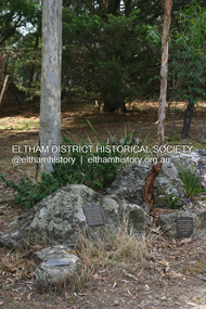
Photograph - Digital Photograph, Alan King, Grave of Gordon Ford, Eltham Cemetery, Victoria, 27 January 2008
Gordon Ford was a conservationist and a pioneer of natural-style landscaping. He came to Eltham in 1948 and bought a block of land in John Street extending through to Pitt Street. Artist Peter Glass lived opposite in John Street. Early on, Gordon worked for Alistair Knox on construction of the mudbrick Busst house amongst others. At the same time, with the help of friends including artist Clifton Pugh, he progressively built his own house ‘Fülling’, which "grew like Topsy" utilising a variety of second-hand materials. His main focus, which became his life-long occupation, was garden landscaping. Inspired by Edna Walling and Ellis Stones, he sought to reflect the bush settings of rural Victoria where he had grown up. Commissions included Monash University and countless industrial sites but designing for the archetypal quarter-acre block gave him the most satisfaction. He had a huge impact on the look of gardens in Australia from the 1950s, creating seemingly natural bush environments by carefully integrating indigenous and exotic plantings. Gordon died in 1999 and is buried in Eltham Cemetery; the gravesite in a natural landscape setting is marked by a plaque. Another plaque (away from his grave) notes his landscaping design work within the cemetery grounds and at Alistair Knox Park. Gordon Craig Ford 30-8-1918 - 16-6-1999 Landscape designer Loved and respected Husband of Gwen, father Of Angela, Emma, Ben, Cassie, Dailan, Caitlin. A good life lived well Published: Nillumbik Now and Then / Marguerite Marshall 2008; photographs Alan King with Marguerite Marshall.; p55This collection of almost 130 photos about places and people within the Shire of Nillumbik, an urban and rural municipality in Melbourne's north, contributes to an understanding of the history of the Shire. Published in 2008 immediately prior to the Black Saturday bushfires of February 7, 2009, it documents sites that were impacted, and in some cases destroyed by the fires. It includes photographs taken especially for the publication, creating a unique time capsule representing the Shire in the early 21st century. It remains the most recent comprehenesive publication devoted to the Shire's history connecting local residents to the past. nillumbik now and then (marshall-king) collection, graves, eltham cemetery, gordon craig ford, gravestones, gwen ford, memorials -
 Eltham District Historical Society Inc
Photograph - Digital Photograph, Alan King, St Margaret's Anglican Church, Pitt Street, Eltham, 30 January 2008
St Margaret’s Church of England was officially opened on December 12, 1861. It is the oldest intact church building in Eltham. At the time it was known as Christ Church until its consecration in 1871, when it was completely free of debt (£1,700 for the church and parsonage) despite the district’s poverty. This was largely due to the free labour and materials, including locally made bricks donated by local artisans and others. The church is historically significant because it is the oldest church in the former Shire of Eltham and has associations with the philanthropist and founder of Brighton, Henry Dendy (who donated the land on which the church is built), the architect Nathaniel Billing and the prominent local builder, George Stebbing. The church is architecturally and aesthetically significant because it is constructed in the Gothic Revival style with several stained-glass windows of various dates and is also a very early use of polychromatic brickwork in Victoria. Billing was one of the first Melbourne architects to employ polychromatic brickwork and an important early architect. The rear wall was intended to be temporary. A major feature of the design is the large buttresses with long, steeply graded upper faces. The overall design is well proportioned with the surface brick patterns relieving an otherwise austere design. The church is spiritually and socially significant because it has been an important place of worship for the people of Eltham for almost 150 years. The land on which the buildings stand was donated by Henry Dendy. Dendy arrived in Melbourne in 1841 after purchasing in England eight square miles at Brighton under the system of "special surveys". After this land passed out of his hands, Dendy moved about Victoria, visited England, then returned to settle in Eltham where he purchased a flour mill. Dendy chaired the meeting held in 1860 “for the purpose of devising such means as may be expedient for the establishment of a Church of England in the township of Eltham”. He became chairman and treasurer of the church committee. Unlike the establishment of many early churches in Victoria where a vicar was appointed to a parish and later a permanent church was constructed, the population at Eltham initiated action to build a church. The nearest church at that time was at Heidelberg and the Eltham settlement was part of the parish of St Johns Heidelberg. Isolation and the tedious, time consuming journey between Heidelberg and Eltham resulted in the Eltham community taking its own action. The original vicarage (Dendy House) at the rear of the church is also an important part of the cultural significance of this place because it is connected to the church and the development of the Eltham area. Together, the church and the vicarage are aesthetically significant because they form a significant streetscape feature. The mud-brick community hall designed by Robert Marshall was added in 1978. In 2014 the original temporary rear wall was removed as part of a modern extension designed by Architects Atelier Wagner and constructed by Conrad Construction and Management. Covered under Heritage Overlay, Nillumbik Planning Scheme. National Trust of Australia (Victoria) State significance Victorian Heritage Published: Nillumbik Now and Then / Marguerite Marshall 2008; photographs Alan King with Marguerite Marshall.; p67This collection of almost 130 photos about places and people within the Shire of Nillumbik, an urban and rural municipality in Melbourne's north, contributes to an understanding of the history of the Shire. Published in 2008 immediately prior to the Black Saturday bushfires of February 7, 2009, it documents sites that were impacted, and in some cases destroyed by the fires. It includes photographs taken especially for the publication, creating a unique time capsule representing the Shire in the early 21st century. It remains the most recent comprehenesive publication devoted to the Shire's history connecting local residents to the past. nillumbik now and then (marshall-king) collection, eltham, st margaret's anglican church, st margaret's church, christ church -
 Eltham District Historical Society Inc
Photograph - Digital Photograph, Alan King, Former St Andrews State School No. 128 building, 23 January 2008
In 1858 the Caledonia Common School No.128 opened at Queenstown, about 1.6km upstream on Diamond Creek from the present site of the old St Andrews school. The school was renamed Queenstown Common School No. 128 in 1867. In 1882, due to declining numbers of pupils at Smiths Gully and increasing numbers in Queenstown the school was moved from a leased building, owned by Head Teacher Robert Harris, into a new larger building on the corner of School and Heidelberg-Kinglake roads which incorporated the original single room school building, which had been moved from Smiths Gully, and included a teacher’s three-roomed residence. In 1887 the school was replaced by the Queenstown State School No. 128. The school and town were renamed St Andrews in 1952. In 1983 a new school was built, 500 metres south of the old school and the old school became the St Andrews Community Centre. Of significance is the c1887 school building (including part of the c1876 Smith's Gully school moved to the site and incorporated into the c1887 school building), the c1911 new room, the c1929 cloakroom, the c1930 renovations, the c1956 new infant room; the c1961 office and storeroom, as well as the c1950 Himalayan Cedar tree and the entire site to the title boundaries. The school building is historically significant for its links with the early settlement of the area and because its use of materials from the former Smith's Gully State school illustrates the common 19th and early 20th century practice of relocating State school buildings based on need. The school building is historically and socially significant because it served the local community, as a school, from 1887 to the late 1970s/early 1980s and because since then it has been used for other community purposes. Covered under Heritage Overlay, Nillumbik Planning Scheme. Published: Nillumbik Now and Then / Marguerite Marshall 2008; photographs Alan King with Marguerite Marshall.; p69This collection of almost 130 photos about places and people within the Shire of Nillumbik, an urban and rural municipality in Melbourne's north, contributes to an understanding of the history of the Shire. Published in 2008 immediately prior to the Black Saturday bushfires of February 7, 2009, it documents sites that were impacted, and in some cases destroyed by the fires. It includes photographs taken especially for the publication, creating a unique time capsule representing the Shire in the early 21st century. It remains the most recent comprehenesive publication devoted to the Shire's history connecting local residents to the past. nillumbik now and then (marshall-king) collection, st andrews, queenstown state school no. 128, smiths gully state school -
 Eltham District Historical Society Inc
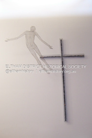
Photograph - Digital Photograph, Marguerite Marshall, Resurrection of Christ. Altarpiece, Charles Rocco (2002); Our Lady Help of Christian's Church, Henry Street, Eltham, 11 October 2006
This alterpiece by Charles Rocco was created with wire mesh, river stones and copper. 500 x 200 x 150cm. It was commissioned by the Catholic parish in Eltham (Our Lady Help of Christian's) in 2002 Published: Nillumbik Now and Then / Marguerite Marshall 2008; photographs Alan King with Marguerite Marshall.; p81This collection of almost 130 photos about places and people within the Shire of Nillumbik, an urban and rural municipality in Melbourne's north, contributes to an understanding of the history of the Shire. Published in 2008 immediately prior to the Black Saturday bushfires of February 7, 2009, it documents sites that were impacted, and in some cases destroyed by the fires. It includes photographs taken especially for the publication, creating a unique time capsule representing the Shire in the early 21st century. It remains the most recent comprehenesive publication devoted to the Shire's history connecting local residents to the past. nillumbik now and then (marshall-king) collection, art, our lady help of christian’s church, charles rocco, eltham, resurrection of christ, sculpture -
 Eltham District Historical Society Inc
Photograph - Digital Photograph, Marguerite Marshall, Parish Hall, St John's Anglican Church, Diamond Creek, 7 September 2008
The building was designed by Charles Maplestone of Heidelberg, son-in-law to Anthony Beale of St Helena. Maplestone was a prominent architect who came out to Australia with his family in 1852. The foundation stone was laid by Mrs Isabella Maplestone on 11th November 1867. The bricklayers for the church were George Stebbing, H Limmer, H Spicer and a Mr Timm while Thomas Day was the stonemason. Another three years were to pass before sufficient money could be raised for its completion. It was opened by Bishop Perry on 1st November, 1870. The church bell which hung under a tree for 50 years until it was incorporated in the parish hall was brought out from England and presented by Charles Orme. In 1916, the estate of George Martin Pizzey left sufficient money to build the red brick hall, which still stands today (2023) though in January 1969 the hall and bell tower were badly damaged by bushfire. Coincidentally the former home of benefactor, George Pizzey was destroyed in the same fire. Of particular significance are the interior and exterior of the church, the Sunday school and hall with emphasis on pre-World War I fabric (excluding the 1990s additions) and the three coloured glass windows currently suspended in the 1990s entry foyer. In 2011 further alterations were made to the front of the Church. The church is historically significant because it was the oldest public building in the former Diamond Valley Shire, is amongst the oldest buildings in the Shire of Nillumbik and is associated with the early settlement of the Diamond Creek district. The church is historically, socially and spiritually significant because it has been a place of worship for over 150 years and continues to be, an important meeting place in the Shire. The church is aesthetically significant for the three stained glass windows executed by the noted stained glass manufacturers, Ferguson & Urie, as well as the supporting coloured glass windows in the church. The Sunday school & parish hall is architecturally significant because the hall is a well executed and preserved example of the work of noted church architects, North & Williams. It is historically significant because it is connected with local parishioner and Melbourne industrialist, George Pizzey, who bequeathed funds for its construction. Covered under Heritage Overlay, Nillumbik Planning Scheme. National Estate Ntionl Trust of Australia (Victoria) Local significance Published: Nillumbik Now and Then / Marguerite Marshall 2008; photographs Alan King with Marguerite Marshall.; p85 References: St Johns Anglican Church complex, Sunday School and Parish Hall 61 Main Street DIAMOND CREEK, NILLUMBIK SHIRE. (2023, June 7). Retrieved from https://vhd.heritagecouncil.vic.gov.au/places/64023 Diamond Creek, VIC. – St John’s Anglican (2023, June 7). Retrieved from https://www.churchhistories.net.au/church-catalog/diamond-creek-vic-st-johns-anglican This collection of almost 130 photos about places and people within the Shire of Nillumbik, an urban and rural municipality in Melbourne's north, contributes to an understanding of the history of the Shire. Published in 2008 immediately prior to the Black Saturday bushfires of February 7, 2009, it documents sites that were impacted, and in some cases destroyed by the fires. It includes photographs taken especially for the publication, creating a unique time capsule representing the Shire in the early 21st century. It remains the most recent comprehenesive publication devoted to the Shire's history connecting local residents to the past. nillumbik now and then (marshall-king) collection, st john's anglican church, diamond creek, parish hall -
 Eltham District Historical Society Inc
Photograph - Digital Photograph, Alan King, Wellers Restaurant, 150 Eltham-Yarra Glen Road, Kangaroo Ground, 23 January 2008
Originally Wellers Hotel, it was constructed by Edward Weller in 1872. Following his death in 1883 it was taken over by his widow, Mary Weller. The hotel was delicensed in 1909 and converted to a private residence. Around 1920 William Pitman bought the property, succeeded by his son Vernon who coined the term Pittman's Corner. Vernon and Isabel Pitman owned the house form 1945-1973. Following Vernon's death, Isabel remained there till her death in 1983. The property was converted to a restaurant in 1984 by owners Robert and Kath Hendry who undertook extensive renovations in 1988. Shawn and Stephanie Wolfe purchased the property from the Hendrys in 2003 and introduced live entertainment with many famous bands and entertainers from the 1960s, 1970s and 1980s performing there, including James Reyne, Daryl Barithwaite, Brian Cadd and Billy Thorpe. In 2014 the Wolfe's sold the property and the entire contents were sold at auction. New (local ) owners Gregory Anderson, Craig Jones and Steve Gist refurbished the property and relaunched it as Fondata 1872 in 2017. Covered under Heritage Overlay, Nillumbik Planning Scheme. Published: Nillumbik Now and Then / Marguerite Marshall 2008; photographs Alan King with Marguerite Marshall.; p87This collection of almost 130 photos about places and people within the Shire of Nillumbik, an urban and rural municipality in Melbourne's north, contributes to an understanding of the history of the Shire. Published in 2008 immediately prior to the Black Saturday bushfires of February 7, 2009, it documents sites that were impacted, and in some cases destroyed by the fires. It includes photographs taken especially for the publication, creating a unique time capsule representing the Shire in the early 21st century. It remains the most recent comprehenesive publication devoted to the Shire's history connecting local residents to the past. nillumbik now and then (marshall-king) collection, eltham-yarra glen road, fondata 1872, kangaroo ground, wellers restaurant, billy thorpe, brian cadd, craig jones, daryl barithwaite, edward weller, gregory anderson, hotels, james reyne, kath hendry, mary weller, restaurants, robert hendry, shawn wolfe, stephanie wolfe, steve gist