Showing 10536 items
matching lander
-
 Eltham District Historical Society Inc
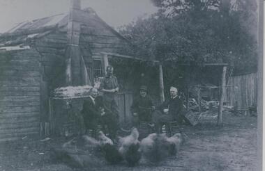
Photograph, Hans Gregory, Original 1860s William West house, Fabbro's Farm, Falkiner Street, Eltham, c.1990
Photos taken by Hans Gregory who along with partner Pauline Steele, rented the original old 1860s William West Cottage situated behind the Fabbro family home. Hans was employed as a Youth officer with the Shire of Eltham at the time and was the last tennant on the property. The property was sold and in 1995 was developed for residential housing as the Riverview Park estate. Guido Quarto Fabbro was born 21 August 1891 at Treppo Grande in the far northeast of Italy, the son of Giacomo Fabbro and Anna Geruzzi. Regina Moretti was born 6 March 1893 at Treppo Grande, Italy, the daughter of Giovanni Battista Moretti and Maria Teresa Coletti. Guido and Regina married about 1917 and they had two sons, Giacomo (John c.1918) and Maurie (c.1920). In 1925 Guido Fabbro departed his homeland from Genoa, arriving in Fremantle, Western Australia in June, travelling 3rd class aboard the ship, Caprera. Regina and their two boys followed a year later along with other family members arriving in Fremantle from Genoa 4 July 1926 aboard the Moncalieri. The Fabbros arrived in Eltham in 1933 and purchased a block of land from William West on the western side of Falkiner Street, extending to Ely and Porter Streets which had formerly been part of the West family orchard and dairy farm. As there was no fencing dividing the two properties, West served notice on Guido in December 1934 to bear half of the cost of £6. When payment was not forthcoming, West sued Guido in the Eltham Court in January 1935. Guido failed to appear and was not represented, and costs were ordered in West’s favour. Guido and Regina built a large Italianesque house on their property. The original 1860s cottage was relocated to the back of the block and was rented out (once to Alistair and Margot Knox). Guido also purchased land extending to the Diamond Creek on the eastern side of Falkiner Street and on the eastern side of Bell Street (opposite Eltham High School). The riparian soil was suitable for market gardening: Guido grew mainly tomatoes, but also pumpkins, cauliflowers, cabbages, peas, beans, lettuce, beetroot and zucchinis. Even the land surrounding the house was used. The produce was carted to Melbourne overnight for sale at the market. Guido died in 1970 and is buried in Eltham cemetery. Regina died 1986. She and their son John Patrick (Giacomo) Fabbro who died in 1984 are also buried at Eltham Cemetery. Guido’s son Maurie continued in his father’s footsteps until 2007, principally growing artichokes in later years. He died in 2009. The land on the eastern side of Falkiner Street now forms part of a Council reserve called “Barak Bushland”, the land on the western side having been sold off for residential subdivision. The Bell Street land is now public open space managed by Nillumbik Shire Council and called “Fabbro Fields”. There have been recent proposals to develop the site for sporting purposes or as a dog park or community garden. Provides an insight into early settler's farmhouses and farming property of the Eltham district.guido quarto fabbro, regina fabbro (nee moretti), william west, maurie fabbro, fabbro's farm, hans gregory, west family orchard, west dairy farm -
 The Beechworth Burke Museum Research Collection
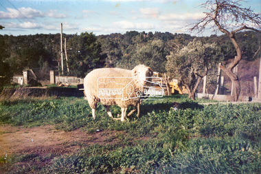
Card (Series) - Index Card, George Tibbits, Ford Street, Beechworth, 1976
George Tibbits, University of Melbourne. Faculty of Architecture, Building and Town & Regional PlanningIndex system that support the research for Beechworth : historical reconstruction / [by] George Tibbits ... [et al]Arranged by street names of BeechworthEach index card includes: street name and number of property, image of property, allotment and section number, property owners and dates of ownership, description of the property according to rate records, property floor plan with dimensions.beechworth, george tibbitsbeechworth, george tibbits -
 Warrnambool and District Historical Society Inc.
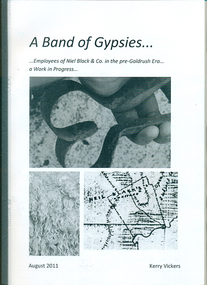
Booklet, A band of gypsies: employees of Niel Black & Co in the pre-goldrush era: a work in progress, August 2011
Niel Black was an early settler in the Western District of Victoria who held large tracts of land including Glenormiston and The Sisters estates. Black was responsible for bringing many employees to the area. The employees' names, birthplace, arrival date, marriage partner/s, other employers are tabulated. An overview of Black's properties and conditions of the time is also included.This booklet documents those who came to the Western District to work for Niel Black prior to the goldfishes of the 1850s.In-house booklet with plastic sleeve outer cover, with black & white images of sheep shears, wool and a map of the Black property. All text is in black.emigration, employment, family history, early victorian squatters -
 Glen Eira Historical Society
Document - Glen Orme Avenue, 2, McKinnon
A one page typed research note by Rosalind Landells of the Brighton Historical Society regarding 2 Glen Orme Avenue / Pinegrove, McKinnon, dated 10/07/1991. The note lists the previous owners of the property and gives a brief history of the land. The file also includes one page of handwritten, undated and unattributed working notes.landells rosalind, bick david, railway park, glen orme avenue, glenorme avenue, mckinnon, pine grove, pinegrove, elster creek, murray road, baker samuel, baker f j, morris j r, dewhurst edward y, jamrich b, dendy henry, were j b, bullock hilary -
 Eltham District Historical Society Inc
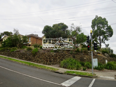
Photograph, Jim Connor, Main Road, Eltham, 14 Jan 2017
Eltham Gateway, Unit complex at 72-74 Bridge Street, Eltham at corner of Main Road. Before reconstruction of Main Road, this intersection had deep cutting embankments on all four corners. Roadworks and private development have levelled the land on the low side of the road. The Eltham War Memorial was originally located on the north western corner.Tomorrow's history documented todayeltham, jim connor collection, main road, eltham gateway, bridge street -
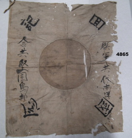 Bendigo Military Museum
Flag - FLAG, JAPANESE, C.1930 - 1945
As per wording supplied by the donor. Flag found on the body of a Japanese soldier by a Coast Watcher found by villagers. He was from a Japanese submarine of New Guinea possibly near Popondetta. It was found hanging in a Long House Papua New Guinea and swapped for a Slouch hat in 1972. Some of the writing is possibly, “On land or sea brothers we are”.Japanese flag with central circle now brownish colour was possibly red as new, around outside are Japanese wording.“Japanese symbols”flags, japanese -
 Federation University Historical Collection
Document, Declaration of Ernest by owners of land in Yendon being held as a site for Public Hall and Free Library; 1891, 1891
Document outlining the agreement between five males, all residents of Yendon. Land that had been purchased - being part of Crown Allotment Five Section six, Township of Buninyong East, Parish of Buninyong, County of Grant, has been purchased "as a site for a public hall and free library for the use and benefit of the inhabitants of the Township of Yendon."Thick paper, hand written. Red dots indicate places for signatures Document stamped in green - 0122083 Signatures of; John Winterburn Kemp, Philip Ballantyne, Samuel Henry Mayo, Thomas Dooley, Thomas Watsondeclaration of ernest, land title, free library, public hall, yendon, buninyong, paris of buninyong, county of grant, john winterburn kemp, philip ballantyne, samuel henry mayo, thomas dooley, thomas watson -
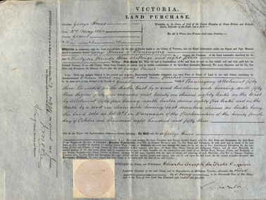 Federation University Historical Collection
Document, Grant, by Purchase, to George Innes, 3 May 1854, 1854
George Innes purchased land in the County of Grant, Parish of Buninyong, for the sum of Thirty-six pounds, three shillings and eight pence. The price paid was for eleven acres one rood and nine perches. The document is witnessed by Charles Joseph La Trobe Esquire on 3 May 1854 in Melbourne. La Trobe was Lieutenant Governor of the Colony of VictoriaThick paper written on by hand. Top edge and right-hand corner damaged Dated 3 May 1854 Signature of Charles Joseph La Trobe and J Moorela trobe, lieutenant governor, george innes, county of grant, parish of buninyong, land purchase -
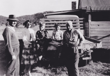
![Photograph - Digital image, Familie Bosch Australien [Bosch/Bush], 1910c](/media/collectors/4f729f5697f83e03086015b8/items/5441ba832162f10c081eab62/item-media/5441bae12162f10c081eae58/item-fit-380x285.jpg) Greensborough Historical Society
Greensborough Historical SocietyPhotograph - Digital image, Familie Bosch Australien [Bosch/Bush], 1910c
Johannes Bosch and family migrated from Southern Germany to Greensborough district. They farmed along the Plenty River having purchased land from Flintoff. Johannes Bosch came to Australia in 1884 aged 17. He married Henrietta Duck, had 3 children and divorced in 1903. Around 1902 he anglicized the family name to Bush.Digital copy of black and white photograph.johannes bosch, bosch family, bush family -
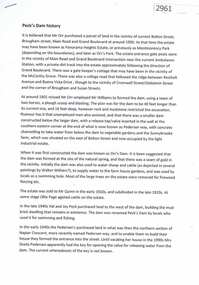 Greensborough Historical Society
Document, Judith Dodd?, Peck's Dam history, 1900o
History of a parcel of land bounded by Bolton Street, Brougham Street, Main Road and Grand Boulevard purchased by Mr Orr around 1900. It may have been called Panorama Heights Estate, Montmorency Park and later, Orr's Park. Orr had a dam made, which was called Peck's dam by locals in the 1940s-1950s.2p. typescriptorrs park, montmorency, pecks dam -
 Halls Gap & Grampians Historical Society
Photograph - B/W
Fred Paasch was born in Denmark in 1862. It is unknown when he arrived in Australia or when he settled in Halls Gap. He owned land generally in the area now occupied by the Halls Gap Supermarket where he established an orchard. See " Bridging the Gap " p.58-60 "Victoria's Wonderland" p.98-99.Shingle and slab house, chimney has loose brick base and tin flue. Four men in foreground. Freddy Paasch, owner of the house is seated in the centre. A number of hens feed in the near foreground. A climbing rose coyers the fence and part of the house roof.buildings, houses, people, paasch -
 Orbost & District Historical Society
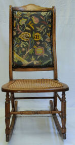
rocking chair, mid 19th century
Brought from Skye, Scotland, in 1850's by Malcolm McLeod, an early Orbost pioneer, and donated by his granddaughter, Margaret McLeod. The tapestry was worked by Miss Grace Cameron. This was possibly a repair job done when acquired by the donor. Grace Cameron was the daughter of John Cameron who selected the first land on the Snowy River flats. The McLeods and Camerons were early Orbost pioneers. This chair has aesthetic significance and reflects the needlework skill of Grace Cameron.Wooden rocking chair with chair cane It has a tapestry back with a floral design. Wire has been placed around the legs for support.chair rocking-chair mcleod-malcolm cameron-grace tapestry -
 Lake Bolac & District Historical Society
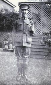
Black and white photograph, Gunner Stanley Herbert Moreton, Field Artillery Brigade, WW1
Gunner Stanley Herbert Moreton, enlisted 04/12/1916 in a Field Artillery Unit. He embarked for France on 11/05/1917. Upon his return from the war, he purchased 'Parupa Park'. After WW2 Stanley was involved in helping with the subdivision of land for soldier settlement. He died in 1978 at the age of 85.moreton, field artillery unit, 'parupa park', soldier settlement, -
 Tatura Irrigation & Wartime Camps Museum
Photograph, Mary Jean Park, 2001
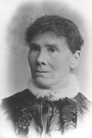
Mary Jean, born 1841, Letterkenny, Co. of Donegal, Ireland. Died 3 Bank Street, Ascot Vale 22.06.1935. Mother of the two Doctors Park. Selected land "Barwood", Nagambie.|Alexander Park, born Conray Co. Donegal 06.05.1832, died 23.04.1911.|Both pictures taken at a Sunday School Picnic, 1898, Nagambie.park, mary jean, alexander, photograph, people -
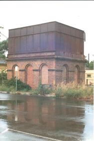 Hume City Civic Collection
Photograph, 1990-1999
The photograph is one of a series of 6 which feature the Sunbury Railway Station complex. The complex includes photographs of the railway station with the wooden pedestrian bridge which has been demolished and two photographs of the water towers. The photographs were taken before the railway land on the west side of the line was developed to make way for a supermarket complex in 2000.A view of the brick and iron water tower which is sited on the Bendigo side of the Sunbury Railway Station. The brick structure at the base has 3 arched recesses across the front and two at the side. Two of the railway buildings are visible on either side of the tower.sunbury railway station, water towers, footbridges, bridges, railways, george evans collection -
 Hume City Civic Collection
Photograph, c1930s
St Mary's Anglican Church was originally built on land in Oaklands Road. It was licensed in 1859 by Bishop Perry, the first Anglican bishop of Melbourne. In the late 1960s the church was dismantled and rebuilt on its present site at Bulla, adjacent to the former Council Chambers. it was shifted to the township of Bulla because the building was under the direct path of a proposed future flightpath.vintage cars, churches, st. mary's anglican church - bulla, george evans collection -
Clunes Museum
Document - RECEIPT
RECEIPT FOR RATE NOTICE FROM BOROUGH OF CLUNES RECEIVED FROM MR WILLIAM BROWN, THE WESLEYAN CHURCH CLUNES FOR GENERAL RATE OF 1/4d IN THE POUND ON THE LAND AND TENEMENT, SEC.4 ALLOT.12 IN SERVICE STREET ORDERED TO BE LEVIED BY THE BOROUGH COUNCIL OF CLUNES, ON 28TH JANUARY 1885 L2.13.4. J.STEPHENS PRO. RATE COLLECTOR.BOROUGH OF CLUNES, GENERAL RATE 1885 - RECEIPT NO.14 ON RATE 33. RECEIVED FROM MR WILLIAM BROWN L2.13.4.RECEIPT SIGNED J.STEPHENS RATE COLLECTORlocal history, commerce, book keeping, churches - wesley -
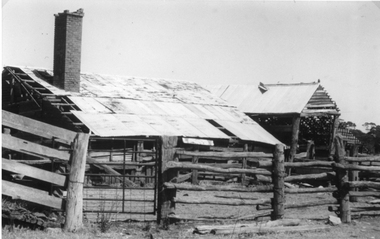 Stawell Historical Society Inc
Photograph, Chaponnel Butchers Slaughter Yard cnr Clifton Avenue and Ormston Road -- 2 Photos & print of painting by Reg Cepon
Butchers Slaughter Yard cnr. Clifton Avenue and Ormston Road which belonged to Chaponnel family. These yards are now demolished. The land being sold for housing. 0099.2 is a photograph copy of an original oil painting titled "The Old Timer" by Reg Capon Nov. 1979. Painting owned by Mr. Phillip Nicholson Clifton Ave. Stawell.Two black and white photographs of a scene depicting a neglected timber building, with corrugated iron roof and brick chimney. Timber fence and race surround the stock yards. The painting (0099.2) is by Reg Capon called "The old Timer" Nov 1979.stawell business -
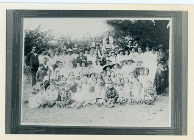 Mt Dandenong & District Historical Society Inc.
Photograph, Picnic in Hand's Paddock
Mountain Grange was the property owned by Thomas Hand. It stood where the Kalorama Oval now is. The land around Mountain Grange was used for community gatherings for cricket and picnics etc.The adults and children in this photograph are not named but would have been local residents. Thomas Hand died in 1888. The picnic was held in 1919 to celebrate Peace after WW1. Black and white photograph of a framed photograph. Shows large group of people dressed in good clothes and hats posed together for the photograph. Handwritten description on reverse by John Lundy-Clarke.Picnic celebrating Peace in 1919 In Hand’s Paddock (Mountain Grange)mountain grange, thomas hand, peace, kalorama oval -
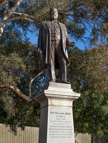 Bayside Gallery - Bayside City Council Art & Heritage Collection
Sculpture, Margaret Baskerville, Sir Thomas Bent, 1913
Arguably Margaret Baskerville’s most famous work, the bronze statue of politician and land speculator Sir Thomas Bent was Baskerville’s first public commission and a significant turning point in her career. Originally located in the centre of the Nepean Highway, in Brighton, it became somewhat of signpost for many Melbournians until it was relocated to the corner of Bay Street in 1980.The statue of Sir Thomas Bent is of historic and social significance to the State of Victoria. The statue is historically significant for commemorating Bent's long, active and infamous political career in Victoria. He was responsible for many important speculative ventures both within his electorate and in the wider context of Victoria. Although not without thought for personal gain, Bent was a committed advocate of public utilities, railways, roads, tramways and gasworks. The statue is historically significant as the first large public commission given to a woman sculptor in Victoria. This work helped the sculptor, Margaret Baskerville, preserve her name as Victoria's first professional woman sculptor. The statue is socially significant as testimony to the late nineteenth century land boom and the financial and political corruption and scandals that accompanied it. https://vhd.heritagecouncil.vic.gov.au/places/12614bronze and granite thomas bent, politician, mayor, premier, bust, sculpture, margaret baskerville, speaker, member of parliament, member of lower house, local government, councillor, brighton, public art, bayside -
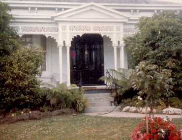 Surrey Hills Historical Society Collection
Photograph, 101 Guildford Road, Surrey Hills
The house was built in 1883, possibly to encourage development of housing on the first urban land subdivision in Surrey Hills, the Windsor Park Estate (in the Windsor Crescent area). This coincided with the opening of the Surrey Hills Railway station. The first occupant was John Brown Nicholson, police magistrate. In 1884 the foundation meeting of the Wyclif Congregational Church was held in the house.Colour photo of the front door and verandah of 101 Guildford Road taken from the street. The house is Victorian in style with ornate lacework along the verandah. It is painted white and has a slate roof. There is a well-maintained garden with flower beds and shrubs, which partially obscure the house.victorian style, wyclif church, houses, guildford road, john brown nicholson -
 Vision Australia
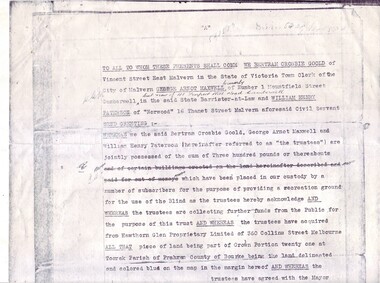
Administrative record - Text, Copy of original Trust Deed for the Kooyong Clubhouse for the Blind, 1926, July 19, 1926
This is an authorised photocopy (date stamped 8th July 1969) of the original Trust Deed for the property holding the Kooyong Clubhouse for the Blind, original dated 19th July, 1926. The wording of the Deed is the same as the Deed of Agreement, but also contains the discussed graphics representing the location and measurements of the land being discussed. The signatures contained are the same as the Deed of Agreement. 3 typed pages of legal agreementassociation for the advancement of the blind, william paterson, george maxwell, kooyong club house -
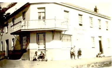 Port Fairy Historical Society Museum and Archives
Photograph
The Stag was built 1848-1854. John Sanders purchased the land from Atkinson in 1848 and built the building as a licensed premises. Over the years it was also used as a Hotel, boarding house, coffee Palace and boarding school. It is still used today as Accommodation and a restaurant. This photo looks like it may have been taken when it was a boarding house.Black and white Photograph of Corner of 2 story building with balcony, 2 males sitting on step and children leaning on wallhotel, seacombe, stag, inn, sackville street, cox street, john sanders, coffee palace, boarding house, boarding school -
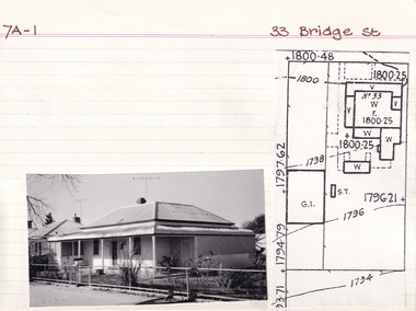 The Beechworth Burke Museum Research Collection
Card (Series) - Index Card, George Tibbits, 33 Bridge Street, Beechworth, 1976
George Tibbits, University of Melbourne. Faculty of Architecture, Building and Town & Regional PlanningIndex system that support the research for Beechworth : historical reconstruction / [by] George Tibbits ... [et al]Arranged by street names of BeechworthEach index card includes: street name and number of property, image of property, allotment and section number, property owners and dates of ownership, description of the property according to rate records, property floor plan with dimensions.beechworth, george tibbitsbeechworth, george tibbits -
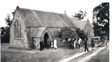
 Sunbury Family History and Heritage Society Inc.
Photograph, Bulla Presbyterian Church
St.Andrew's Presbyterian Church at Bulla was built on Crown land that the congregation received on 6th September 1858. It overlooks Oaklands Road and the surrounding farms as well as the Tullamarine Airport. The building at the rear is the former manse. It functioned as a place of worship for over 150 years and celebrated its 150th anniversary in 2009. The entire property is now privately owned.It was one of the first permanent church buildings to be built in the district.A non-digital black and white photograph, with a cream border, of a blue-stone church with a high-pitched slate roof and a tall belfry its the main entrance. A smaller residence is visible in the background. The buildings have been erected in an open grassed area.presbyterian church, bulla, oaklands, churches -
 Sunbury Family History and Heritage Society Inc.
Postcard, John Sands Pty. Ltd, Emu Bottom
The homestead featured on the postcard is 'Emu Bottom', which is claimed to be Victoria's oldest homestead, although over the years sections of the homestead have had to be rebuilt as result of fires so little of the original materials remain in the building. The homestead was built by George Evans in the 1830s when he squatted on a tract of land in the Jacksons Creek valley in Sunbury. A non-digital coloured photograph in post card format of a single storey homestead with a timber shingle roof. A timber post and rail fence is across the front of the property. The post card has a crinkled edge.'emu bottom', george evans, homesteads, jacksons creek, sunbury -
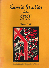 Victorian Aboriginal Corporation for Languages
Book, Catholic Education Commission of Victoria, Koorie studies in SOSE : years 7-10, 2001
Section 1. Notes on the use of this resource Section 2. Policy support statements. Aboriginal Studies Policy Statement of Victorian Aboriginal Education Association Incorporated (VAEAI) National Principles and Guidelines for Aboriginal Studies and Torres Strait Islander Studies, K-12 Principles for the Introduction of Aboriginal Perspectives in the Curriculum of the Catholic School (Catholic Education Commission of Victoria Policy 1.3, 1987) Section 3. Language, culture and viewpoint: issues of terminology Section 4. Units of work Unit 1. Koorie people of south-east Australia: a contemporary view Unit 2. On sacred ground Unit 3. Koorie life in the pre-contact era Unit 4. Mulla Meea-Baa Gnuenjall: a long time ago, and today Unit 5. The land we share: human stories in the environment Unit 6. Frontier wars Unit 7. Aboriginal mission stations and reserves in Victoria Unit 8. Land, law and indigenous Australians Section 5. Directory of indigenous organisations and affiliated groups/?agencies. National organisations Victorian organisations Catholic Education Commission of Victoria Indigenous Education personnel Organisations within regions of the Archdiocese of Melbourne Organisations within regions of the Ballarat Diocese Organisations within regions of the Sale Diocese Organisations within regions of the Sandhurst Diocese Cultural centres/?camps across Victoria.maps, b&w photographsvaeai, history, curriculum development, koorie studies, catholic education commission of victoria, secondary school education, -
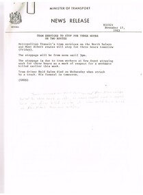 Melbourne Tram Museum
Document - Press Release, Minister of Transport, "Press Statement", Nov. 1987
Set of 11 New Releases or Press Releases with Minister of Transport letterhead. Photocopied onto A4 paper. 1. Tram services to stop for three hours on North Balwyn and Mont Albert - 18/11/1983 as a mark of respect to Naid Salem when struck by a truck at the Mont Albert terminus on 16/11. (hand written not on the sheet). 2."The Met" fare system starts today - Steve Crabb - 13/11/1983. 3. "New tram a design to meet the needs of the year 2000" - Minister visits Comeng Plant - A class trams 4. "Bonus travelcard on sale" - 10/11/1983 5. "A tram for the year 2000" - follow up - issued 11/11/1983 - A class trams. 6. "New Rail land sale on tomorrow - sale of surplus land in Doncaster - Templestowe Area" - following a decision to consider light rail rather than heavy rail. 7 "Homes now getter Transport Information Booklet" - explaining the Neighbourhood system. 8. "One Million booklets to be home delivered to explain The Met transport system" - 6/11/1983. 9. "Public Transport more cost efficient than the car" - 7/11/1983 - looks at The Met tickets pricing. 10. "Boards name for the New Transport Authorities" - 28/6/1983 - lists the names for the various authorities.Item 4 has a handwritten note in ink "NB now half a "Grand Union" at Sydney Road & Moreland Rd"trams, tramways, news broadcasts, minister for transport, mont albert, tickets, a class, doncaster, neighbourhood tickets -
 The Beechworth Burke Museum
Audio - Oral History, Jennifer Williams, Hubert Warner, 2 April 2000
Hubert Warner’s story shows insight to the families that emigrated from Europe for the gold rush. It illustrates the nuances of life in the district. This history speaks of land cultivation and the innovation of industry in the region, in particular sheep and cattle farming and slaughter. Warner speaks of the highs and lows of the practice of breeding cattle, the awards he won, but also the hardships that come with working on the land such as having to face natural disaster. This oral history recording was part of a project conducted by Jennifer Williams in the year 2000 to capture the everyday life and struggles in Beechworth during the twentieth century. This project involved recording seventy oral histories on cassette tapes of local Beechworth residents which were then published in a book titles: Listen to what they say: voices of twentieth century Beechworth. These cassette tapes were digitised in July 2021 with funds made available by the Friends of the Burke.Hubert Warner's account of life in Beechworth is uniquely illustrative as it captures many aspects of the community. It explains the motivation for European migrants for choosing to settle in the area and how they were able to both become a part of and create a presence in their local community. This oral history also exemplifies the process of developing industry through the twentieth century, how it was done, the struggles it faces, and the triumphs that came with this. Warner's history is specific to the cattle industry and shows great nuance in the day-to-day operation of such a business over time. This is a digital copy of a recording that was originally captured on a cassette tape. The cassette tape is black with a horizontal white strip and is currently stored in a clear flat plastic rectangular container. It holds up 40 minutes of recordings on each side. Herbert Warnerlisten to what they say, listen to what they say: voices of twentieth century beechworth, 1800s beechworth, 20th century beechworth, beechworth, farming and agriculture, cattle, gold, gold rush, farm, farming -
The Beechworth Burke Museum
Audio - Oral History, Jennifer Williams, Robert Mason, 3 August 2000
Mason Robert was born in (unintelligible) in 19(unintelligible). Mason's grandparents were from Stanley, where Mason completed his schooling. Mason started working for the Forestry Commission in 1939 looking after Crown land but eventually went into the army in 1942. At the Forestry Commission, he was responsible for maintaining and looking after the land. Mason later went to work for the Lands Department after working at the Commission for seven years. This oral history recording was part of a project conducted by Jennifer Williams in the year 2000 to capture the everyday life and struggles in Beechworth during the twentieth century. This project involved recording seventy oral histories on cassette tapes of local Beechworth residents which were then published in a book titled: Listen to what they say: voices of twentieth century Beechworth. These cassette tapes were digitised in July 2021 with funds made available by the Friends of the Burke.Mason Robert's account of his life in Beechworth and the local area during the 20th century is historically and socially significant to the cultural heritage of the region. He recalls some of the changes that Beechworth underwent such as the introduction of electricity in the 1950s and an increase in tourism. His account is important to the region's history in terms of important historical events such as WWII and other events impacting the region. This oral history account is socially and historically significant as it is a part of a broader collection of interviews conducted by Jennifer Williams which were published in the book 'Listen to what they say: voices of twentieth-century Beechworth.' While the township of Beechworth is known for its history as a gold rush town, these accounts provide a unique insight into the day-to-day life of the town's residents during the 20th century, many of which will have now been lost if they had not been preserved.This is a digital copy of a recording that was originally captured on a cassette tape. The cassette tape is black with a horizontal white strip and is currently stored in a clear flat plastic rectangular container. It holds up 40 minutes of recordings on each side.Mr. Robert Mason/beechworth, mason robert, forestry commission, lands department, crown land, wwii, listen to what they say, burke museum, jennifer williams, oral history