Showing 10536 items
matching lander
-
 Orbost & District Historical Society
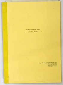
document, BALDWIN SPENCER TRAIL Project Brief 1988, February 1988
This document was produced by the Department of Conservation, Forests & Land Management, Orbost, to commemorate the visit by Baldwin-Spencer in 1989 as part of the Bicentennial Walking Tracks Project. The Baldwin Spencer Trail closely follows the route of scientist and explorer William Baldwin Spencer. Sir Walter Baldwin Spencer KCMG (23 June 1860 – 14 July 1929) was an English-Australian biologist and anthropologist. this booklet is a useful reference tool.A document of 10 pp with a cream cover, titled, Baldwin Spencer Trail Project Brief Feb 1988. It contains mapsbaldwin-spencer -
 Orbost & District Historical Society
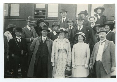
black and white photograph, 1916
About 1912 work began at Newmerella on clearing the track for the railway line from Bairnsdale to Orbost. A canvas town sprang up on the higher land adjacent to the river flats. Local farmers supplied meat, milk and fresh produce to the camp, as well as gaining employment carting and labouring. The line opened in 1916, the Orbost railway station being built on the Newmerella side of the river. This item is associated with the history of the Orbost-Bairnsdale railway line and therefore reflects the role that the rail line played in the social and economic history of Orbost. On April 10 1916, the first scheduled train service left Orbost for Bairnsdale. The Bairnsdale-Orbost railway was opened to serve the agricultural and timber industry. Because of the decline in traffic and heavy operating costs, the line was finally closed in August, 1987.A black / white photograph of a group of people standing next to a train carriage.orbost-railway east-gippsland-railway celebration-opening-of railway -
 Orbost & District Historical Society
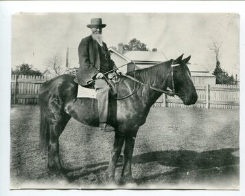
black and white photograph, early 20th century
Edward James Pardew died in 26/9/1927 aged 92. He came to Orbost from New Zealand in 1886 and selected 720 acres of hill land in the Brodribb area. He was a member of the first Orbost Shire Council. His daughter had a fruit & meat shop in McLeod Street. He was an inaugural vestryman of St James Church of England. Edward Pardew was a prominent Orbost citizen in the late 19th / early 20th century.A black / white photograph of a bearded man wearing a hat sitting on a horse. He is holding a horse whip. a riding crop. Behind him is a fenced house.pardew-edward -
 Orbost & District Historical Society
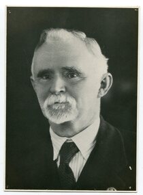
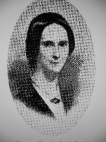
black and white photograph, C1877
This is a photograph of Mr Harry Felix . Richardson who selected land at Bete Bolong in 1887. He married Elizabeth Wardle in 1893 and had no children. Harry Richardson was a keen angler, rifle shooter and cricketer and was very much involved with the local community. With his brother, Alan, he had pioneered the move to the Snowy in 1878. He died in Bairnsdale , aged 83, in 1941.Harry Richardson was a prominent and active member of the Orbost community in the late 19th and early 20th centuries.A black / white portrait photograph of a man with wavy hair, a small white beard and moustache. -
 Warrnambool and District Historical Society Inc.
Document - Invitation to the opening of the Parliament of the Commonwealth of Australia, 2014
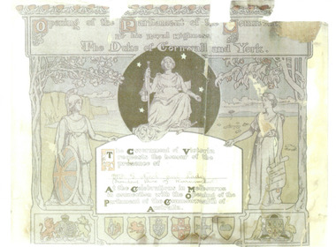
Gideon Nicol (1836-1908) was a seaman who came to Warrnambool in 1858. In 1865 he selected land at Mount Warrnambool. He was one of the founders of the Farnham Cheese and Butter Factory and the Garvoc Cheese and Butter Factory and was a Warrnambool Shire Councillor from 1879 to 1906. He received to invitation to attend the opening of Australia’s first Parliament as the President of the Warrnambool Shire at the time. This scan will be useful to include in the Gideon Nicol file.This is a scan of an invitation to Gideon Nicol and Lady as President of the Shire of Warrnambool for the opening of the first Parliament of the Commonwealth of Australia in 1901. It is on an A4 sheet. Multi-coloured sketches of Britannia etc with invitation detailsfederation, gideon nicol, warrnambool, opening of parliament -
 Warrnambool and District Historical Society Inc.
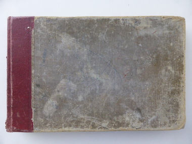
Book, City Poundkeeper's Book, C 1950
This book records the impounding of animals which have been found wandering on local roads or trespassing on land. Many are farm animals and give the various breeds of animals from red Ayrshire cows to bay ponies, and nanny goats. Impounded animals were either claimed by their owners after payment of a fee or if unclaimed , they were sold. The Warrnambool pound was situated on Merrivale Drive.This book is a record of a practice which was necessary to remove stock which were wandering on local roads or trespassing on neighbours. It contains many local names and is of social interest. Rectangular book with hard cover Fawn cloth with red leather spine. Pages are lined in blue and red and pages are headed in black . It dates from 1957 to 1998 with one entry for 2004.Entries are hand written in blue and black. The entries give particulars of the animal impounded and where found with name of council officer and owner, if known, of the animal.various pieces of paper pasted inside front cover.There are many names included in this journal. Among the earlier entries are James P O'KeefeH C Bidmade, Keith Nixon, C Eccles, I Carmody,warrnambool, warrnambool pound -
 Warrnambool and District Historical Society Inc.
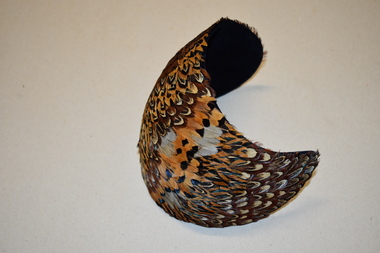
Feathered Hat, Custom Hats, c. 1940
This item comes from the great aunts of the donor, women of the Kinnear family of Allandale, Allansford. In the early 1840s William and John Allan took up large tracts of land to the east of the Hopkins River. In the late 19840s the run was divided, with William taking the Allandale section and John taking the Tooram section. In 1906 a portion of the Allandale section, including the homestead, was acquired by the Kinnear family. This hat is retained as an example of a woman’s hat from 80 years ago – stylish and eye-catching. It is also of interest as coming from the Kinnear family of Allansford.This is a woman’s hat – a spherical-shaped piece of dark blue felt or velvet curved to fit a head. The headpiece is covered with layers of small feathers in brown, yellow, black and white tonings. The label of the maker is on the inside of the hat. Urbi et Orbi Custom Hats Yokohamavintage hats, kinnear family, allansford, history of warrnambool -
 Warrnambool and District Historical Society Inc.
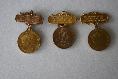
Medallion, Stokes Melbourne, Commemorative Queen Elizabeth 11 1954 Visit, C 1954
This was the first visit of Queen Elizabeth to Australia following her coronation in 1953. Queen Elizabeth is the only British monarch to have visited Australia. She visited Hamilton on 26th February. School children from Warrnambool were transported to Hamilton showgrounds to stand in lines to view the Queen and the Duke standing in a land rover. All school children received a commemorative medal.These medals are retained as a memento of the Queen's visit in 1954.Three identical gold coloured metal medals. Each medal is attached by a ring to a bar with decorative surrounds. The bar has text. The obverse of the medal features profiles of Queen Elizabeth 11 and the Duke of Edinburgh. The reverse has a crown and text. There is a pin clip on the reverse of the bar. Bar Obverse PRESENTED TO THE CHILDREN BY THE GOVERNMENT OF VICTORIA Bar Reverse STOKES MELB Medal Obverse QUEEN ELIZABETH 11 : DUKE OF EDINBURGH Medal Reverse E11R ROYAL VISIT 1954 VICTORIA queen elizabeth 11. duke of edinburgh, royal visit -
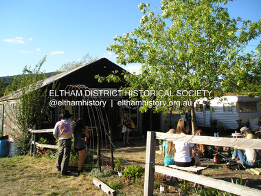 Eltham District Historical Society Inc
Photograph, Fay Bridge, Bobby Bununngurr appearing at the Black Barn Gallery, Christmas Hills, January 2016
The Black Barn gallery at Christmas Hills was designed and built by Justus Jorgensen, founder of Montsalvat. The space has been a part of community and the arts for three generations. Bobby Bununngurr is a songman and multi art form creative from Ramingining (his outstation is Ngalayindi) in Central Arnhem Land. Fund raising event at Christmas Hills for the Black Barn gallery - being filmed for a video fay bridge collection, 2016-01, black barn gallery, bobby bununngurr, christmas hills, maurice hurry, rhiannon jorgensen, sebastian jorgensen -
 Glen Eira Historical Society
Letter - Hoddle Street, 23, Elsternwick
A copy of a two page valuation of 23 Hoddle Street, Elsternwick, dated 03/09/1976, from valuator W V Scott. The valuation provides a description of the land and house improvements. The file also includes one page of unattributed, undated, handwritten working notes for the purposes of the valuation. The file also includes a rate notice for the property from the City of Caulfield.negus vera m, elsternwick, hoddle street, baxter street, brick houses, flats, romeo f a, caulfield council, rents and renting, receipts, architectural features, scott w v, rates -
Glen Eira Historical Society
Document - Nettalie
Two photocopies of the October 1994 Caulfield Conservation Study by Andrew Ward of the house at 73 Balaclava Rd Caulfield named Nettalie by 1899. In the documents(s) Ward details the history of ownership and land values the architectural features and historical significance. A bibliography is included as well as a photograph of the front facade of Nettalie which like the study includes two copies but of varying sizes.ward andrew, forsyth william, forsyte william, noall william, grimwade frederick shepherd, desailly alfred, bryant bessie, bryant herbert, ware martha, cameron william, nettalie, balaclava road, orrong road, caulfield north, fosbery ave, netley, harleston, caulfield north, historic building register, national estate register, national trust register, melbourne grammar school, cast iron work, verandahs, victorian style, stained glass, architectural features, architectural styles, brick houses, stables, mansions, pharmacists, lawyers, doctors, flats, schools, bay windows, land values -
Glen Eira Historical Society
Letter - Centre Road, 229, Bentleigh
A two page typed copy of a letter dated 21/10/1966 to Mrs Thompson from valuer W V Scott containing a valuation of her property at 299 Centre Road, Bentleigh. It includes a detailed description of the land, room layouts and out buildings. Also includes two pages of undated, unattributed handwritten working notes relating to the valuation of the property.thompson mrs, centre road, bentleigh, whitmuir road, architectural features, garages -
 Wycheproof & District Historical Society Inc.
Bunguluke Map, Bunguluke District In 1923, 27.2.1923
By 1881 Bunguluke was a small settlement as recorded, December 5, in the Charlton "Mercury". It reports that in that year Draper's Store, Hotel and Post Office and residence at Bunguluke North was totally destroyed by fire. For years now there has been little sign of community life with houses few and far between and acreages have gone into larger holdings. The map references land blocks and owners for that era.This important map shows the local land ownership and local features that existed in 1923. This is a photocopied black and white map of Bunguluke in the County of Kara Kara, Number L5149. Marked - Photo Lithographed by W.J. Butson 27.2.1923. The details include numbers of allotments, property owners, roads, rivers. The boundaries marked are the Parish of Jeruk, Parish of Wycheproof, Parish of Cooroopajerrup. Wycheproof township location is shown with the Scale of Chains. Bunguluke maps for other years are also in the collection.map, bunguluke, jeruk, wycheproof, cooroopajerrup -
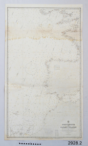 Flagstaff Hill Maritime Museum and Village
Document - Navigation Chart, Portsmouth to Canary Islands, CA. 1928
Navigation charts are drawn by professional hydrographers and describe the geography of land and water, enabling a water based navigator on board vessels such as ships to safely negotiate between ports locally and around the world. They are drawn to a particular standard with common symbols noting landmarks. The charts are used in conjunction with other navigational instruments and tools to calculate the vessel’s exact location and a safe route to its destination.The set of charts and their chart are of significance as examples of equipment and documents used to navigate the oceans of the world, particularly to Australia. Migration to Australia is an important part of this country's history.British Admiralty Navigation Chart - Portsmouth to Canary Islands - printed on rectangular white paper. Published in London by the British Admiralty in 1928.warrnambool, shipwreck coast, flagstaff hill, flagstaff hill maritime museum, flagstaff hill maritime village, chart, map, navigate, navigation, location, vessel, 1928, british admiralty, hydrographer, geography, admiralty chart, portsmouth, canary islands -
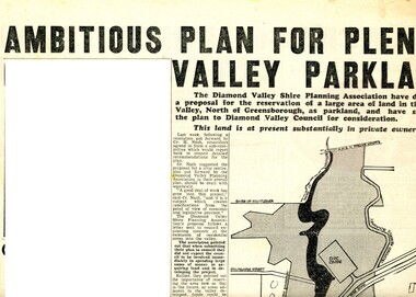 Greensborough Historical Society
Newspaper Clipping - Digital Image, Ambitious plan for Plenty Valley Parklands 1965, 05/11/1965
In 1965, the Diamond Valley Shire planning association recommended to Council that a large area of land north of Greensborough be acquired for Parkland. The idea of a Civic Centre was included with a map of the area from Grimshaw Street in the south to the MMBW pipeline reserve in the north. Includes a suggested new site for the local school, near Yando Street. This area is now part of the Plenty River Trail.An example of developments in the Greensborough area during the period of Shire of Diamond ValleyNews clipping, black and white text and map. Scanned in 3 parts.shire of diamond valley, civic drive greensborough, yando street greensborough, partingtons flat, plenty river trail -
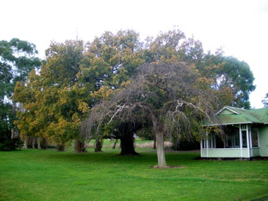 Mortlake and District Historical Society
Queen Victoria's Oak Tree
This magnificent English oak tree is located at Tea Tree Lake park in Mortlake. This park was formerly the Botanic Gardens which were developed on what had been swamp land. An artificial lake was created there in 1988 as a Bi-Centenary project.The tree is located adjacent to the historic Montgomery Pavillion and was planted on the occasion of Her Majesty Queen Victoria's birthday on 24th May 1883. An outstanding tree, planted to commemorate a much-revered Queen in an historically-significant Botanic Gardens (now much altered). A very old oak tree planted 1883. queen victoria, mortlake, mortlake botanic gardens, tea tree lake, montgomery pavillion -
 Greensborough Historical Society
Photograph - Digital image, Mrs Edward Green, 1850c
Portrait of Mrs Edward Green. In the 1840s, Edward B. Green ran the mail service between Melbourne and Sydney and owned a parcel of land on the Plenty River. He engaged a surveyor to draw up plans and lay out a township on the slopes overlooking the river, and to mark out small farm holdings on the flats. This small township named after him is now Greensborough.Digital copy of portraitedward bernard green -
 Cockatoo History & Heritage Group
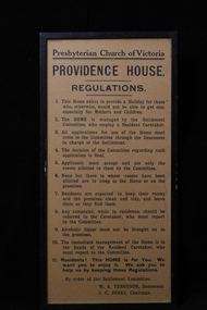
Regulations, Providence House Regulations, Cockatoo Victoria
The Presbyterian Church owned three lots of land bounded by Pakenham Road and the northern side of Dorchester Road, between 1927 and 1964. Providence House opened in 1927 as a peaceful country rest home for “tired mothers” from the inner suburbs, and their children. It was also used, at different times, for kindergarten groups and in 1955 for a girls Bible Class for Easter “studies, fun and fellowship.”Cockatoo had several guest houses which took paying guests. Providence House did not charge fees, but is the best-documented of the large houses which provided accommodation.Framed regulations for the Presbyterian Church of Victoria's Providence House in Cockatoo.providence house, cockatoo victoria, presbyterian church, regulations, -
 Cockatoo History & Heritage Group
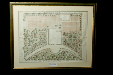
Landscape Plan, Providence House Cockatoo, 1930's
The Presbyterian Church owned three lots of land bounded by Pakenham Road and the northern side of Dorchester Road, between 1927 and 1964. Providence House opened in 1927 as a peaceful country rest home for “tired mothers” from the inner suburbs, and their children. It was also used, at different times, for kindergarten groups and in 1955 for a girls Bible Class for Easter “studies, fun and fellowship.”Cockatoo had several guest houses which took paying guests. Providence House did not charge fees, but is the best-documented of the large houses which provided accommodation.Framed landscape design plan under glass, with detailed plant listings. Original watercolourDonated by Victoria & Digby Newcombe 2003presbyterian church, rest home, landscape plan, garden design, cockatoo victoria, providence house, black n.c, -
 Puffing Billy Railway
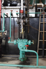
Steam Driven Weir Pump, 1900s
Weir Pumps - these types of vertical pumps were used extensively with both land and marine steam pumps. The pumps were also used for various duties from pumping oil fuel and feed water for boilers, to draining bilges on steam ship[s They are a single cylinder, double acting vertical pumps used by G. & J. Weir Ltd. , of Cathcart, Glasgow Historic - Weir Vertical PumpSteam Driven Weir Pump Green and Black with metal parts.No. B49717puffing billy, weir, steam pump -
 Hume City Civic Collection
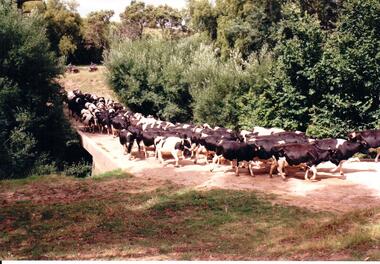
Photograph, c late 1980s
The series of photographs show a number of sites included in the Rupertswood Estate. By 1851 William Clarke had acquired 31,375 acres of land in the Sunbury district. The foundation stone for Rupertswood Mansion was laid on 29th August 1874 by Mrs. W. J. Clarke, daughter-in-law of 'Big Bull'. The Salesian Fathers bought the Rupertswood property in June 1927 and established Salesian College.A coloured photograph of a herd of Fresian cows crossing a small bridge on the Rupertswood Estate. The cows were from the agricultural studies faculty at Salesian College.rupertswood estate, clarke, william j. t. 'big bull', salesian brothers, george evans collection -
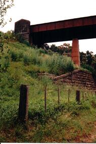 Hume City Civic Collection
Photograph, c late 1980s
The series of photographs show a number of sites included in the Rupertswood Estate. By 1851 William Clarke had acquired 31,375 acres of land in the Sunbury district. The foundation stone for Rupertswood Mansion was laid on 29th August 1874 by Mrs. W. J. Clarke, daughter-in-law of 'Big Bull'. The Salesian Fathers bought the Rupertswood property in June 1927 and established Salesian College.A coloured photograph of the bluestone and iron rail bridge over the Jacksons Creek on the Rupertswood Estate. One stone pylon at the top of the embankment and an iron pylon are visible along with the stone wall at the base of the embankment and part of the iron span. A post and wire fence is in the foreground.rupertswood estate, clarke, william j. t. 'big bull', salesian brothers, george evans collection -
 Whitehorse Historical Society Inc.
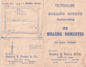
Document, Hollins Estate, 1955
Private sale of 22 hillside home-sites on Junction Road, Blackburn, called Hollins Estate by Stanley R. Penny & Co., 524 Whitehorse Road, Mitcham.hollins estate, stanley r. penny & co., real estate agents, blackburn, junction road, suto, joyce -
 Whitehorse Historical Society Inc.
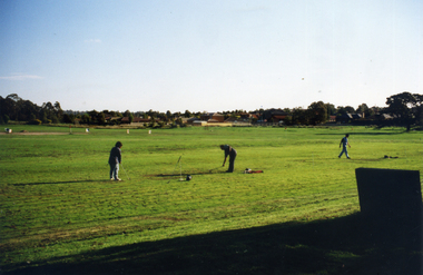
Photograph, Morack Golf Course, C1970
In 1970, the area now known as the Morack Golf Course was rezoned from 'Rural' to 'Public Open Space'. This allowed planning to go ahead and by 1973 sufficient land had been acquired by the Melbourne and Metropolitan Board of Works. The course was first open on 8 May 1976 as a nine-hole course. This was extended to 15 holes by January 1980, and to eighteen holes by 1981.Two coloured photographs a-b of the early days in the development of the Morack Golf Course. Overview of a hole plus white patches indicating where trees have been planted. Some people practicing.morack golf course -
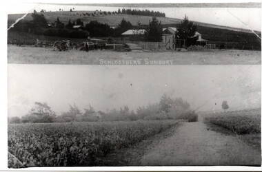 Hume City Civic Collection
Photograph, Schlossberg Vineyard, 1909
Schlossberg Vineyard was situated along Vineyard Road in Sunbury, between Winilba and the Calder Highway. It was established by Felix Frederick Bubeck, who arrived in Australia from Rotenberg (near Stuggart) in the 1860. In 1866 he acquired 60 acres of land on Bald Hill and established the vineyard. In 1880, claret produced on the property received an honourable mention when it was exhibited in Bordeaux, France,From the mid 1850s a number of vineyards were established on the hillsides overlooking Vineyard Road. The east facing outlook that captured the morning sun was ideal for growing grapevines. Other vineyards were also established in the area at the same time.A black and white copy of a postcard of two photographs mounted on the one card with the original handwritten message photocopied on the back. To my dear brother & sister with love and good wishes for a Merry Xmas & a prosperous 1909. Thanks for the paper Your loving sister Marie. You will think it a good photo You will see the trees have grown almost hiding the house. Mr. A Senling, Cheetham St. Kalgoorlie Sth. WAfelix frederick bubeck, schlossberg vineyard, bald hill, vineyards -
 Kew Historical Society Inc
Photograph - Flooding of the Yarra River in North Kew, 1934
North Kew, now divided between Kew and Kew East, bordered the Yarra River. As such, it was a region subject to flooding in the Yarra Valley. Development beyond this point (ie Kellett Grove) was limited by the City of Kew's planning regulations. Prior to urban development, the area since European settlement and the first land sales in the district in the 1840s, had been used for dairy farming. Small sepia snapshot taken from the river ramp of a house at 8 Kellett Grove, in what was then known as North Kew. The point of view is from a backyard looking towards Fairfield. Beyond the fence line are two almost submerged houses. A number of people are in a motor driven boat midstream. Fairfield at this period, (ie 1934) was noted for its limited river side development. Verso: 2/12/34 / TAKEN FROM OUR RAMPyarra river -- north kew, floods -- yarra valley, floods -- north kew, floods -- 1929, floods -- 1934, natural disasters -- kew -
 Kew Historical Society Inc
Photograph - 8 Kellett Grove, North Kew, 1929
North Kew, now divided between Kew and Kew East, bordered the Yarra River. As such, it was a region subject to flooding in the Yarra Valley. Development beyond this point (ie Kellett Grove) was limited by the City of Kew's planning regulations. Prior to urban development, the area since European settlement and the first land sales in the district in the 1840s, had been used for dairy farming. Small sepia snapshot taken of the front of 8 Kellett Grove, in what was then known as North Kew. Verso: 8 KELLETT GROVE / NORTH KEW / 1929 / 418 kellett gove -- north kew, californian bungalows, houses -- kellett grove -- kew (vic.) -
 Kew Historical Society Inc
Photograph - Flooding of the Yarra River in North Kew, 1934
North Kew, now divided between Kew and Kew East, bordered the Yarra River. As such, it was a region subject to flooding in the Yarra Valley. Development beyond this point (ie Kellett Grove) was limited by the City of Kew's planning regulations. Prior to urban development, the area since European settlement and the first land sales in the district in the 1840s, had been used for dairy farming. Small sepia snapshot taken from the back yard of a house at 8 Kellett Grove, in what was then known as North Kew. The point of view is from a backyard looking towards Fairfield. Floodwaters have submerged the fence and a clothes line. Verso: BACKYARD NTH. KEWyarra river -- north kew, floods -- yarra valley, floods -- north kew, floods -- 1934, natural disasters -- kew -
 Kew Historical Society Inc
Photograph - Flooding of the Yarra River in North Kew, 1934
North Kew, now divided between Kew and Kew East, bordered the Yarra River. As such, it was a region subject to flooding in the Yarra Valley. Development beyond this point (ie Kellett Grove) was limited by the City of Kew's planning regulations. Prior to urban development, the area since European settlement and the first land sales in the district in the 1840s, had been used for dairy farming. Small sepia snapshot taken from the back yard of a house at 8 Kellett Grove, in what was then known as North Kew. The point of view is from a backyard looking towards Fairfield. Verso: 8 KELLETT GROVEyarra river -- north kew, floods -- yarra valley, floods -- north kew, floods -- 1934, natural disasters -- kew -
 Kew Historical Society Inc
Photograph - Flooding of the Yarra River in North Kew, 1934
North Kew, now divided between Kew and Kew East, bordered the Yarra River. As such, it was a region subject to flooding in the Yarra Valley. Development beyond this point (ie Kellett Grove) was limited by the City of Kew's planning regulations. Prior to urban development, the area since European settlement and the first land sales in the district in the 1840s, had been used for dairy farming. Small sepia snapshot taken from the back yard of a house at 8 Kellett Grove, in what was then known as North Kew. The point of view is from a backyard looking towards Fairfield. Verso: OUR BACKYARD 8 KELLETT GROVEyarra river -- north kew, floods -- yarra valley, floods -- north kew, floods -- 1934, natural disasters -- kew