Showing 15583 items
matching stillwell-valley
-
 Eltham District Historical Society Inc
Document - Folder, Reeves, Michael
Eltham resident Police Sergeant Michael Reeves won the 1996 Ethnic Communities Police Annual Award for his work with Somalian refugees. Contents Newspaper article: "Award for work among refugees", Diamond Valley News, 23 October 1996. Outline of Michael Reeves' work with Somalian refugees in West Heidelberg.Newspaper clippings, A4 photocopies, etcmichael reeves, somalian refugees, west heidelberg, north west migrant resourve centre -
 Greensborough Historical Society
Map, Melbourne and Metropolitan Board of Works. Survey Division, MMBW, Yarra 2500 / 13.23. Plenty, Happy Hollow, 1979_03
Melbourne and Metropolitan Board of Works. Yarra 2500 [base map] 13-23. Plenty / Happy Hollow. Parishes of Morang 3183, Nillumbik 3310 and Keelbundora 2856. Municipalities of Diamond Valley 257 and Whittlesea 239. Prominent streets include: McLaughlans Lane and Happy Hollow Drive. Includes Janefield Colony Reserve.MMBW Map in 1:2500 [scale] series. Cream parchment with green tape reinforcing on edges and punched holes on left edge.mmbw, melbourne and metropolitan board of works, shire of diamond valley, plenty - maps, happy hollow -
 Greensborough Historical Society
Map, Heidelberg: Historic River Landscape Assessment. Historical maps. Map D 1864 -1901 "Sleepy Hollow" and "Sleeping beauty", 1985c
Geographical area of c. 35 sq. kilometres marked with physical features such as major roads, rivers, vegetation and properties, with locations and notes on the increasing number of farms, orchards and vineyards that had been developed in addition to pastoral runs. Bounded by Shire of Diamond Valley to the North, Darebin Creek to the West, and Plenty River to the East.Black and white sketch on white paper. Second copy 600 x 430 cm printed in black on semi-opaque paperheidelberg, heidelberg - maps -
 Greensborough Historical Society
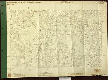
Map, Melbourne and Metropolitan Board of Works. Survey Division, MMBW, Yarra 2500 / 15.20. Eltham, 1977_08
Melbourne and Metropolitan Board of Works. Yarra 2500 [base map] 15.20. Eltham. Municipalities of Diamond Valley 257 and Eltham 238. Prominent streets include: Main Road, Henry Street and Livingstone. Features include the Eltham Station, Catholic Ladies' College, Judge Book Memorial Village and Eltham Central Park.MMBW Map in 1:2500 [scale] series. Cream parchment with green tape reinforcing on edges and punched holes on left edge.mmbw, melbourne and metropolitan board of works, shire of diamond valley, nillumbik, eltham - maps -
 Greensborough Historical Society
Map, Melbourne and Metropolitan Board of Works. Survey Division, MMBW, Yarra 2500 / 13.23. Plenty, Middle Gorge, 1978_04
Melbourne and Metropolitan Board of Works. Yarra 2500 [base map] 13-23. Plenty / Middle Gorge. Parish of Morang 3183. Municipalities of Diamond Valley 257 and Whittlesea 239. Prominent streets include: Gorge Road, Kurrak Road and Browns Lane. Features include the Plenty River and Plenty Gorge Park.MMBW Map in 1:2500 [scale] series. Cream parchment with green tape reinforcing on edges and punched holes on left edge.mmbw, melbourne and metropolitan board of works, shire of diamond valley, plenty - maps, plenty gorge park -
 Halls Gap & Grampians Historical Society
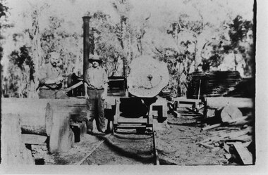
Photograph - B/W, C 1910
The photo shows a timber mill in the Grampians. Neither the location nor the people are known. Note: The photo may have been taken by Guy E. Neate of "Rosebank" on Neates Road in the Victoria Valley, however Guy Neate did not buy that property until June 1926 (see the book "Water Between the Hills".The photo shows two men standing beside a trolley with a large log on it. There are other logs to the left and some sawn wood is visible stacked towards the back.timber industries, logging, sawmilling -
 Uniting Church Archives - Synod of Victoria
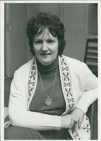
Photograph, c. 1977
Linda Blundell was employed by the Presbytery of Maribyrnong Valley, arranged by the Presbytery Minister of the time, the Rev. Brace Bateman. She was employed to work with Broadmeadows families, in particular with those who had got into financial difficulties through excessive borrowing and the somewhat unscrupulous advertising tactics of some businesses. The problem was seen as acute at the time.This was the first person to be employed by the Maribyrnong Valley Presbytery in a purely social worker-type capacity.B & W waist length photograph of Mrs Linda Blundell, seated, wearing a white cardigan. linda blundell; brace bateman; presbytery of maribyrnong valley; broadmeadows -
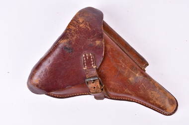 Chiltern Athenaeum Trust
Accessory - Revolver (Luger) Case, 1917
Owned by Martin Balsarini, a resident of Chiltern Valley, for use in WW1. Service Number 1682. Martin Balsarini enlisted on the 21/7/1915 and served with the 4th Australian Lighthorse, AIF. He participated in what is known as the last great cavalry charge, the charge of the 4th Australian Lighthorse at Beersheba on the 31/10/1917. WW1 owned by Chiltern Valley Resident Soldier Martin Balsarini who was in the Charge of the Lighthorse at Beersheba with the 4th Australian Lighthorse on the 31/10/1917. Brown Leather Luger Revolver Case for attachment to belts webbing WW1. 1. Etched into the inside leather cover : J. A. Stanien... 1917 Berlin. 2. Stamped into the inside leather case black ink in Black Markings : B.A.X1 ww1, revolver case, balsarini, chiltern., martin balsarini -
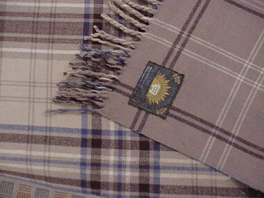 National Wool Museum
Rug
Mr Mears father Horace Mear bought the rug c1933. He was ex British Navy and had migrated to Australia in 1920. Horace worked as a loom tuner at Valley Woollen Mill Geelong in the early 1920's then worked at Federal Woollen Mills as the Manager of the Weaving Room until his death in 1952.RETSOL RUG D E MEARwoollen mills - history, returned soldiers and sailors mill valley worsted mill federal woollen mills ltd, retsol rugs, weaving -
National Wool Museum
Letter
Letter from H. Krantz Sohne, Manufacturers of Finishing Machinery, Aachen, Germany to Arthur Heaton & Co. Ltd, Valley Works, Liversedge, Yorkshire, England, dated 2 Nov. 1931. This letter contains a quotation for obtaining a Kettle Decatizing apparatus and a Cloth Winding Machine. It was sent with two photographs of the machinery in question.textile machinery textile finishing, h. krantz s?? arthur heaton and co. ltd, decatizing, winding machinery, textile machinery, textile finishing -
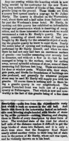 Ballarat Heritage Services
Newspaper - Newspaper article, Newsclipping Relating to Stonemason Julien Hardy
Julien Hardy was the first discoverer of gold at Happy Valley. A stonemason, he was born at Vire, Normandy, France. He established a stone quarry on the Melbourne Road, near Warrenheip (on the site now occupied by Shady Acres Caravan Park). From here, he quarried blocks that were used in the Ballarat Town Hall.Newsclippingjulien hardy, stonemason, gold, happy valley, shady acres, warrenheip, ballarat town hall -
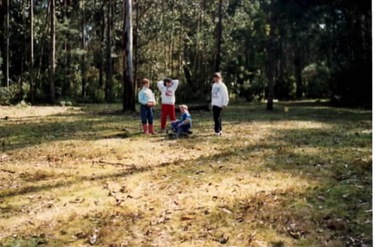 Sunbury Family History and Heritage Society Inc.
Photograph, Gundiwindi School camp, 14th - 18th August 1989
The photograph was taken in 1989 when students in Grades 4 and 5 from Bulla Primary School attended a school camp at Gundiwindi Camp. The camp is in the Yarra Valley area on the border of North Wandin and Silvan. At the camp the children were learning bush survival skills, which were practised by the local indigenous people.The emphasis on the camp at Gundiwindi was bush survival and skills used by indigenous people.A non-digital coloured photograph of four children in a bushland setting attempting to build a camp fire in the cleared area. the forested area is behind the group.school camps, gundiwindi, bulla primary school, indigenous culture -
 Kiewa Valley Historical Society
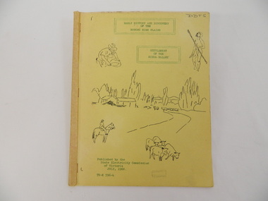
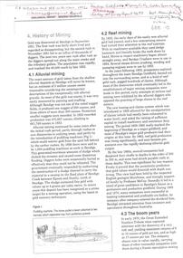
Book - Bogong High Plains x2, Early History and Discovery of the Bogong High Plains, 1968
The State Electricity Commission of Victoria constructed the Kiewa Hydro Electric Scheme in the north east of Victoria. Mr R.M. Duncan prepared the notes. He was a member of the S.E.C. Kiewa Branch from 1949 - 1966. This book was commissioned by the State Electricity Commission of Victoria. It consists of the early history of the Bogong High Plains and the origin of names of places and creeks in the area.This book was researched in 1968 by Mr R.M. Duncan who worked for the S.E.C. on the Kiewa Hydro Electric Scheme from 1949 to 1966. His sources were the Melbourne Public Library, the Victorian Historical Society, the North Eastern Victorian Historical Society and the Dept. of Crown Lands & Survey, Melbourne. The book is an accurate history of the Bogong High Plains given the available records at the time. Yellow cardboard covered book with black sketches and green print. 9 one-sided pages held together by 3 staples and taped over the staples. One - has sheets enclosed "The Three Floras of Bogong" and "General Geology of the Kiewa Area". 6 copies including 1 that is a photocopyDDTS hand written on front cover "Early History and Discovery / of the / Bogong High Plains" on cover top centre. "Settlement / of the / Kiewa-Valley" on cover towards the top slightly to the right. "Published by the / State Electricity Commission / of Victoria / July, 1968" on cover bottom left. "TR-K 596-4" on cover bottom left.bogong high plains. state electricity commission of victoria. kiewa. aborigines. kiewa valley. mullindollingong pastoral run. flora. geology -
 Bendigo Historical Society Inc.
Document - CAROL HOLSWORTH COLLECTION: GEOLOGICAL REPORT BENDIGO GOLDFIELD
Four page document, an extract from the Geological Report on the Bendigo Goldfield. On front page, a line drawing of a puddling machine. Contents include: alluvial mining, reef mining, the boom years, deep sinking, decline of mining, modern exploration, physiography, the hills, the valleys and the soils. A table demonstrates the development of graptolite structures, including the Lancefieldian, Bendigonian, Chewtonian and Castlemainian graptolite species. Two diagrams demonstrate saddle and bedded reefs and fault reefs. Written on top of the document: C.E. William and H.E. Wilkinson, 1992. Geological Survey Report No. 93.bendigo, mining, geological bulletin 93 -
 Bendigo Historical Society Inc.
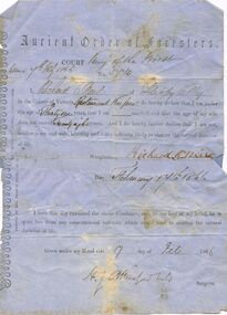
Document - ANCIENT ORDER OF FORESTERS NO. 3770 COLLECTION: CORRESPONDENCE
Printed declaration from Richard O Neil of Happy Valley, Restaurant Keeper, declaring that he is under the age of 31 years and that his wife does not exceed 28 years and that they do not have any infirmity likely to shorten the natural duration of life. Also signed by H. L. Atkinson that he has examined the Candidate and to the best of his belief, he is quite free of any infirmity which would tend to shorten the natural duration of life. Dated February 17th 1866. Printed by Bro Graham Berry,, at The 'Observer' Office, Collingwood.societies, aof, correspondence, ancient order of foresters no. 3770 collection - correspondence, court king of the forest, richard o neil, h l atkinson -
Southern Sherbrooke Historical Society Inc.
Information folder - Lysterfield
Information folder containing items pertaining to the history of Lysterfield. Contents: -Articles copied from Knox HS newsletter, inc. Lysterfield, Lysterfield Road, -typescript, "Early settlement of the district later known as Lysterfield", 5 pages -typesccript, "William Lyster and the Lysterfield Valley", 2 pages -map, part of parish map of Scoresby, showing holdings in Lysterfield -illustrations, "A Victorian Model Farm: Nareewarran Grange" -illustration, The Homestead (Nareewarran Grange), 2 copies -copy, 'The Golden Age Of Australian Opera', Chapter 7, an account of William Lyster at Lysterfieldwilliam lyster, lysterfield, nareewarran grange -
 Bendigo Historical Society Inc.
Map - LONG GULLY HISTORY GROUP COLLECTION: MAP OF LONG GULLY/CALIFORNIA GULLY AREA
BHS CollectionTwo copies of a map, printed on yellow paper, of the Long Gully/California Gully Area. It shows Eaglehawk Road from Craig Street then Mr Korong Road,to the Murray Valley Highway to just past Avenue Street. Sandhurst Road and Holmes Road are to the right. To the left is California Gully Road. Water Supply Purposes Reserve, Mental Hygiene Authority, Comet Hill State School Reserve, Agricultural Showgrounds and Recreation Reserve, Rubbish Reserve and two un-named State Schools are shown. Some contours are also shown.bendigo, history, long gully history group, the long gully history group - map of long gully/california gully area -
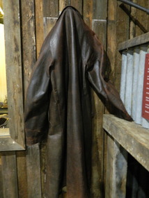 Kiewa Valley Historical Society
Coat - Cattleman's
Cattlemen wore coats when working with their cattle especially during the winter in the Kiewa Valley and when travelling on horses with cattle to, on and from the High Plains where they stayed for days during summer attending and mustering their cattle. The coats protected the cattlemen from harsh weather conditions including snow which sometimes fell in summer. This coat was owned and worn by Richard Marum who owned a farm in Tawonga south. He was the descendant of Kyran Marum, the stockman, who worked for Georgina Huggins. Brown leather full length coat with collar, lapel, long sleeves and buttoning up the front. Instead of pockets the coat has an opening about 12 cm on each side that look like pockets.cattlemen, leather coat, bogong high plains, marum family, tawonga south -
Eltham District Historical Society Inc
Document - Folder, McKellar, Jamie
Jamie McKellar was awarded a Medal of the Order of Australia (OAM) for service to the community through the development of a construction-waste recycling industry and his commitment to environmentally sustainable industrial practices. He was managing director of the Alex Fraser Group. Contents Newspaper article: "Talent in waste turnover" Diamond Valley Leader, 21 June 2006.Newspaper clippings, A4 photocopies, etcjamie mckellar, james mckellar -
 Greensborough Historical Society
Map, Heidelberg. Historic River Landscape Assessment. Historical maps: Map C 1851-1863. "The Garden of the colony", 1985c
Geographical area of around 35 sq. kilometres marked with physical features such as major roads, vegetation and properties, with locations and notes of the increasing number of farms, gardens orchards and vineyards which had become established in addition to pastoral runs. Bounded by Shire of Diamond Valley to the North, Darebin Creek to the West and Plenty River to the East.Black and white sketch map on white paperheidelberg, heidelberg - maps -
 Greensborough Historical Society
Map, Melbourne and Metropolitan Board of Works. Survey Division, MMBW, Yarra 2500 / 14.27. Yarrambat, Yan Yean Road, 1978_04
Melbourne and Metropolitan Board of Works. Yarra 2500 [base map] 14.26. Yarrambat, Yan Yean Road. Parishes of Morang 3183 and Greensborough 2724. Municipality of Diamond Valley 257. Prominent streets include: Yan Yean Road, North Oatlands Road and Pioneer Road. Features include Yarrambat War Memorial Reserve.MMBW Map in 1:2500 [scale] series. Cream parchment with green tape reinforcing on edges and punched holes on left edge.mmbw, melbourne and metropolitan board of works, shire of diamond valley, whttlesea, yarrambat - maps -
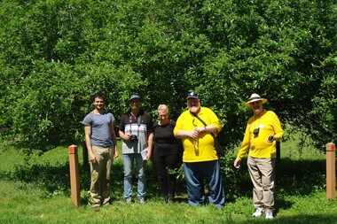 Greensborough Historical Society
Photograph - Digital image, Marilyn Smith, Heritage Day, October 2015, 24/10/2015
Groups of Greensborough Historical Society members at the Heritage Day celebrations 2015. The first photo shows participants in the Heritage Walk in front of the Batman Apple Tree; the second photo shows a group at Diamond Valley Learning Centre with exhibits from the GHS collection. More photos of this event can be found at the GHS Resource Centre.Digital copy of colour photographs.greensborough historical society, heritage day 2015 -
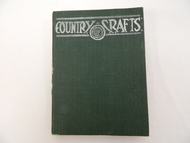 Kiewa Valley Historical Society
Book - Country Women's Association of Victoria, Country Crafts - CWA, 1950
This book is a periodical that the Tawonga C.W.A. group received each year with news, hints, ideas etc. of all CWA groups in Victoria. The Tawonga branch of the C.W.A. commenced on the 7th Feb. 1946 and often combined activities with the other branches in the Kiewa Valley. The C.W.A. aimed to improve health, welfare and education for women and children in the country.Women living in Tawonga were mostly on farms and, in 1946, when the branch commenced would have been feeling more remote with WW11 having had an effect on available workers and the well being of the women and children.Hard covered bound green book with 345 slightly yellowing pages. 1949 periodical book Vol. XIX No.1 (- 12) 1st January 1949 - (December) reporting on activities of C.W.A. clubs in Victoria. It is set out month by month but isn't indexed. Subscription: 4/- per annum; 5/- per year, posted; 4d. per Copy, 5 and a half pence postedCover: "Country Crafts with CWA logo."country women's association of victoria. country crafts. tawonga. c.w.a. -
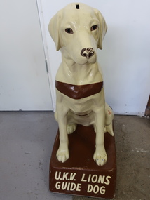 Kiewa Valley Historical Society
Collection Guide Dog (A) and Award Pennant (B)
The Upper Kiewa Valley Lions Club sponsored a Collection Guide Dog. Money was collected regularly by Guide Dog volunteers. The funds are used for Guide dog training programs. They are trained to guide a person who has low vision, disability or illness. It began in the 1950s and by 1957 there was a guide dog organisation in each Australian state .UKV Lions club was active in the Kiewa Valley raising money for charities eg. Blind Institute. Collection dogs were used as a novel way to collect money and easily supported by businesses etc. In 2024, our society is becoming cashless creating a problem for collection dogs etc. with donations more often made by internet banking.A) Light coloured 'plastic'/'ceramic' labrador dog with a brown strap, a money slot is on the top of his head, and he is sitting on a brown stand. B) Cloth Pennant is triangular and long mostly white (dirty) with blue print and logo and a blue border. The end for attaching is of purple bias binding with two hooks for attaching to a stand. B) Pennant: 'Royal Guide Dogs Association / Mobility/ '78 / For the Blind / Community/ Service Award'guide dogs, upper kiewa valley lions club, fund raising, blind people -
 Ballarat Tramway Museum
Document, 'State Electricty Commission of Victoria Rail Transport: Yallourn Open Cut"
Provides details of the history of SECV rail operations in the Yallourn and other power station open cuts and the transport of coal and the locomotives used in the Latrobe Valley operations of the SEC. Possibly prepared in the early 1980s. Rail operations on the interconnecting railway ceased in 2000. Shows outline diagrams of the steam, electric and diesel locomotives and the coal wagons.Provides information about the SEC Coal railways and their rolling stock used for power generation in Victoria.Report or document - 16 A4 pages titled Report - 'State Electricty Commission of Victoria Rail Transport: Yallourn Open Cut"sec tramways, power supply, secv, open cut mining, locomotives, interconnecting railway -
 8th/13th Victorian Mounted Rifles Regimental Collection
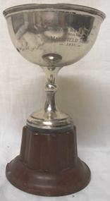
Decorative object - trophy, 1938 circa
The 20th Light Horse (Victorian Mounted Rifles) was raised in 1920 as part of the 3rd Cavalry Brigade, 2nd Cavalry Division, Citizen Military Forces, with Headquarters at Seymour and depots along the Goulburn Valley from Mansfield to Tocumwal in southern NSW. The regiment was still horse mounted in 1937 when this trophy was awarded to the Mansfield Troop. Fine example of a trophy awarded to a Citizen Military Forces sub-unit drawn from a country town in northeast Victoria prior to WWII. Silver cup with no handles and bakelite base being a trophy for snap shooting in 20th Light Horse Regiment.20th Light Horse Regiment Shoot / Snap Shooting / won by / Mansfield Troop / 1937mansfield, shooting, light horse, 20th -
 Eltham District Historical Society Inc
Document - Property Binder, 672 Main Road, Eltham
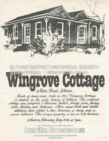
Flyer, Neville Emerson Pty Ltd, for sale Wingrove Cottage. Shire of Eltham Heritage Study, nd but post 1989: Wingrove Cottage. Note: June 1997 re Judy David, descendant of Mr Wingrove. Note: 2 September 2003: Greg Johnson description of building. Statement 2 September 2003 from Francis Percival (Jock) Read of memories of Wingrove Cottage. Copy letter 21 October 2002 from Value Creating Environments (recent purchasers of Wingrove site) to John Karageorge Planning and Building Services Nillumbik Shire re planned work; also attachment re possible site development. Newspaper article: Diamond Valley Leader, 23 October 2002, Angry crowd stops demolition, photograph of part demolition. Letter 30 December 2002 from Stephen Coleriro Acting Manager Planning and Building Services Nillumbik Shire re consultation on illegal demolition works at Wingrove Cottage. Letter 24 February 2003 from Allom Lovell & Associates to John Karageorge Shire of Nillumbik commenting on Wingrove Cottage work. Newspaper article: Diamond Valley Leader, 17 September 2003, Court orders restoration at cottage. Newspaper article: Diamond Valley Leader, 25 February 2004, Health vision for Eltham's 1800s home, Wingrove Cottage will be restored as health and wellness centre if plans approved. Newspaper article: Diamond Valley Leader, 7 July 2004, 1850s bricks in debris, Jim Cummane owner ordered to prepare conservation plan, photograph of site and Harry Gilham president Eltham District Historical Society. Newspaper article: Diamond Valley Leader, 1 December 2004, Cottage heritage plan crucial to sale success, site to be sold, photograph of Wingrove Cottage. Letter 14 April 2005 from Gaye Van Donkelaar Planning and Building Services Nillumbik Shire to Russell Yeoman Eltham District Historical Society re meeting of key stakeholders 27 April 2005. Newspaper article: Diamond Valley Leader, 28 March 2007, Cottage work on hold, recent purchasers Cameron Construction restored Cottage, open as photographic studio, applied for permit to build office and 7 homes on site. Letter 13 August 2007 from Senior Registrar VCAt to Eltham District Historical Society enclosing VCAT order re application for 672 Main Road. Letter 24 August 2007 from Colin Bowden Planning and Development Consultants to VCAT enclosing response prepared by O'Brien Traffic for VCAT. Letter 14 February 2007 from Jeremy Livingstone Planning and Building Services Nillumbik Shire, invitation to review re planning application.main road, eltham, property, houses, wingrove cottage -
 Lilydale RSL Sub Branch
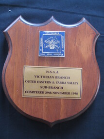
Plaque, National Servicemen's Association Australia NSAA
Unit badge mounted on wooden plaqueBadge - Square on blue background surrounded by the words (left) National 51, (top) Servicemen's, (right) Association 72, (bottom) Navy Army Airforce. (Central) Over map of Australia are the crown, crossed swords, eagle, anchor. Plate below badge reads - Eastern and Yarra Valley/ Sub-Branch/ Chartered 29 November 1998 -
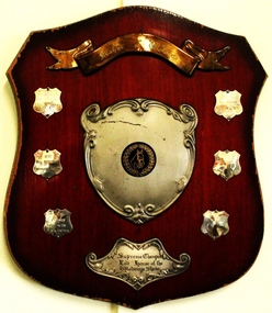 Wodonga & District Historical Society Inc
Award - Mann's of Wodonga Supreme Champion Led Horse Shield
In a "LED HORSE" category, the horse is presented bridled and unsaddled. The handler leads the horse in clockwise direction on the circle. The horse is required to walk and trot and stand to be judged. The judge looks for correct conformation of the horse as well as ahorse that is neatly presented and in good condition. Straight movement, correctness and quality of paces and obedience of the horse are also taken into consideration. This trophy was sponsored by Manns of Wodonga. The Mann family operated a major business in Wodonga for 85 years, beginning with a produce store in February 1921. It expanded to become one of Australia’s largest regional shopping centres, with a Supermarket, Hardware Store, Steel Store, Plumbing and Industrial supplies store, at one stage employing well over 100 people. The Mann Family sold the business in 2006.This item has local significance as it records winners in equestrian events at the Wodonga Show. The award was also presented by a prominent citizen of Wodonga.A wooden shield with metal plaques engraved with names and year of competition winners for the Supreme Champion Led horse at the Wodonga Show.On gold toned banner at top: "Manns of Wodonga" On bottom plate: Supreme Champion/ Led Horse of / the Wodonga Show" On smaller shields: "1976/MISS M McINTYRE/ GREEN VALLEY/CALYPSO", "1977 /MISS M McINTYRE/BIRRAHLEE LONICERA" , "1978/J. VINGE/ HILLINVIEW/BLACK PANTHER" , "1979/MRS A. WILKINSON/SWEET SUE"equestrian events wodonga show, wodonga show, supreme champion led horse, mann wodonga -
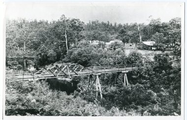 Orbost & District Historical Society
black and white photograph, c1920-1954
This is a copy of "THE BRIDGE AT BOGGY CREEK, NOWA NOWA, LAKE TYERS." which is a Rose Stereograph Co postcard. Boggy Creek Bridge was built in 1916 as part of the Bairnsdale to Orbost extension to the main Gippsland Railway, and is situated in the middle of the township of Nowa Nowa, crossing a steep-sided and well-timbered creek-valley. This section of the line closed in 1987. This bridge plays a major part in the identity and history of the town of Nowa Nowa, This item is associated with the East Gippsland Railway.A large black / white photograph of a large wooden bridge across a creek. There is a house and outbuildings in the background on the right. It is in a bush setting. on back - "Boggy Creek bridge - Nowa Nowa 1887 LaTrobe Collection"boggy-creek-bridge east-gippsland-railway