Showing 560 items
matching land sales.
-
 Warrnambool and District Historical Society Inc.
Memorabilia - Two articles of civic events in Warrnambool, Kaye & Son, Warrnambool Printers, mid 20th century
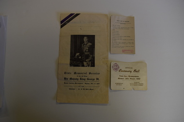
... the farming interests in the area, with the first land sales held... the farming interests in the area, with the first land sales held ...The card relates to the Official Centenary Ball held in the Warrnambool Town Hall in March 1947 to celebrate the city's Centenary in 1947. Warrnambool was founded as a port settlement to service the farming interests in the area, with the first land sales held in Melbourne in July 1847. The leaflet is a programme of the Civic Memorial Service held in the Botanic Gardens in Warrnambool in February1952 on the occasion of the death of King George VI of England. Both items came from memorabilia held by the Bamford family of 8 Monash Avenue Warrnambool and it is presumed that one or more members of that family attended the events.These items are of social significance as mementos of events in Warrnambool in the mid 20th century..1 A white card with black printing and a logo .2 A sheet of white paper folded to make four pages with black printing and a photograph of King George VI of Englandwarrnambool memorabilia, warrnambool centenary, warrnambool centenary 1947, official centenary ball. -
 Echuca Historical Society
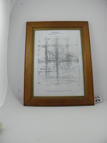
Map, Map of Township - Echuca
... of ECHUCA dated March 1855, One month before the first land sales... of ECHUCA dated March 1855, One month before the first land sales ...Map on white paper that has yellowed. Black print Handwriting is black but faded. In wooden frame behind glass. Printed Survyor's plan for Echuca Township, date 5th March 1855, from the Surveyor General Office. Melbourne March 5th 1855 Plan drawn by P Chauncey. Hand written- This plan is now a Port for the South Australian Steamer Trade - when Hopwood settled here/ it was only a wild bush - he is now throwing a bridge/ at his own cost across this river 200yards wide. signed by Henry Hopwood. Typed on backing paper: Plan of the township of ECHUCA dated March 1855, One month before the first land sales / Autographed by Henry Hopwood in Oct 1955. -
 Warrnambool and District Historical Society Inc.
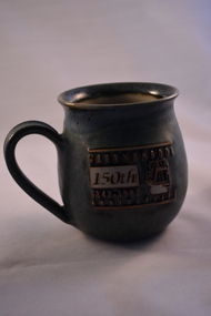
Household, Souvenir Cup (Warrnambool’s 150th ), 1997
... of Melbourne and the first land sales were held in Melbourne in July... and the first land sales were held in Melbourne in July 1847 ...This cup was produced by Ken Sadler as a souvenir of the 150th anniversary of the settlement of Warrnambool. Ken Sadler was a potter in Liebig Street, Warrnambool for many years (end of 20th century and beginning of 21st century). Warrnambool was founded as a planned town in 1847 to provide port facilities for the produce of squatters who had settled in the area. The town centre was surveyed by William Pickering at the request of Superintendent La Trobe of Melbourne and the first land sales were held in Melbourne in July 1847. The celebrations to mark the 150th anniversary of Warrnambool included concerts, race meetings, church services and the erection of an anniversary tablet on Cannon Hill. Ken Sadler, a well-known Warrnambool potter, made 500 of these cups which are now collectible souvenirs of the city’s 150th anniversary celebrations. This one retained by the Warrnambool and District Historical Society is numbered 189. The 150th anniversary of the founding of Warrnambool was an important event in the city’s history.This is a ceramic cup with a round base and larger rounded body with a round overhanging rim at the top opening. The cup is mottled green with an impressed image of a ship and lettering in white, gold and brown. There is some lettering on the bottom of the cup.‘Warrnambool 150th Anniversary 1847-1997’ ‘Sadler 97 189/500 Warrnambool’ warrnambool’s 150th anniversary, history of warrnambool, ken sadler, warrnambool potter -
 Bacchus Marsh & District Historical Society
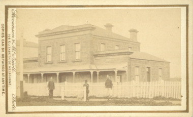
Photograph, Court House Main Street Bacchus Marsh 1883
... and a Crown Land sales office. Other uses included an office... and a Crown Land sales office. Other uses included an office ...The Court House in Main Street Bacchus Marsh was built in 1858 using local sandstone. It opened in 1859. It has been used for jury trials, a Court of Petty Sessions, a County Court and a Crown Land sales office. Other uses included an office for the Registrar of Births and Deaths, a Dairy Inspectors office from 1863-1865, and as meeting rooms for the Bacchus Marsh Roads Board, a forerunner of the Shire Council. It was also used by the Bacchus Marsh Shire Council for its offices until at least 1884. In more recent years it has functioned as a Magistrates Court with weekly court sessions. Small sepia unframed photograph on card with gold border framing photograph. Housed in the album, 'Photographs of Bacchus Marsh and District in 1883 by Stevenson and McNicoll'. The view of the Court House building is seen from the northern side of Main Street looking south or south-east. Three men are standing in the street in front of the building. The men on the left and the right wearing police helmets appear to be police officers. The man in the middle is in civilian clothes and might be an officer or employee of the Court House. He has his dog with him. A white picket fence runs along the front of the building. The front courtyard of the building has been renovated since, but this building still operates as a court house.On the front: Stevenson & McNicoll. Photo. 108 Elizabeth St. Melbourne. COPIES CAN BE OBTAINED AT ANY TIME. On the back: LIGHT & TRUTH inscribed on a banner surmounted by a representation of the rising sun. Copies of this Portrait can be had at any time by sending the Name and Post Office Money Order or Stamps for the amount of order to STEVENSON & McNICOLL LATE BENSON & STEVENSON, Photographers. 108 Elizabeth Street, MELBOURNE. stevenson and mcnicoll 1883 photographs of bacchus marsh and district, courthouses, bacchus marsh court house -
 Stawell Historical Society Inc
Archive - Finance, Papers
... Rural Finance Land Titles Sales Smith St Sth Standard... grampians Rural Finance Land Titles Sales Smith St Sth Standard ...Rural Finance Land Titles Sales Smith St Sth Standard association of Australia Licence Morias Pty Ltd Agreement Agreement between R.Maxwell & North Western Woollen Mills Melbourne Wool Brokers Authority to buy.norwellen, industry -
 Kew Historical Society Inc
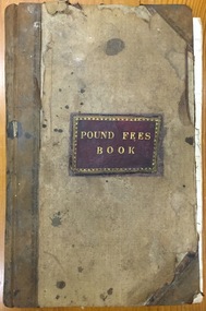
Administrative record (item), Borough of Kew, Pound Fees Book, 1874-1896
... While the first successful land sales in Boroondara... While the first successful land sales in Boroondara occurred ...While the first successful land sales in Boroondara occurred in Hawthorn in 1843, and Kew in 1845, these areas were to be without local pounds until April 1858, when the Governor of Victoria, in accordance with Act 18 Victoria No 30, was pleased to direct the establishment of a Pound at Glass’s Creek on that part of land bounded by the Kilby Road, Burke Road and High Street. While the Governor was required to proclaim the establishment of a pound, the appointment of a poundkeeper was the responsibility of the Justices of the Peace in the local Court of Petty Sessions. The Pound took its name from the most distinctive natural feature of the area, Glass’s Creek, named after the early pastoralist Thomas Glass.The register is of historic significance as an indicator of suburban life in the second half of the 19th Century. It shows how farming and city life on the urban fringe were intimately connected. It is also significant to the early history of Hawthorn and Kew, who both claimed the Pound following their separation from the Boroondara Roads Board in 1861."Kew Pound Book"glass creek pound (kew), animal pound, dog pound, kew pound, j. smith, john oakes, samuel b. cash, edward s. delaney, emma oswin, samuel cash -
 Kew Historical Society Inc
Photograph - Willsmere [Kew] Billabong, 1993
... at the Crown Land Sales of 1846 (Section 56). From the 1840s... Land Sales of 1846 (Section 56). From the 1840s to the 1940s ...Willsmere Park is bounded by the the Yarra River, Green Acres Golf Club, Willow Grove and the Eastern Freeway. The land on which the park is now situated was bought by Thomas Wills at the Crown Land Sales of 1846 (Section 56). From the 1840s to the 1940s it was intensively farmed. The park is dominated by very large playing fields, while planting to the southern boundary was undertaken when the Eastern Freeway was built. It is only along the banks of the Yarra that there is any remnant native vegetation. Willsmere Park is of significance as an area of open land that remains from the flood plain that once dominated northern Kew. (Source: Kew Conservation Study, 1988)Original colour small format polaroid photograph of the 'Kew Billabong' in the Willsmere Park, taken on 16 September 1993."Willsmere Billabong 16.9.93"kew billabong, willsmere park, yarra river -- billabongs -
 Kew Historical Society Inc
Photograph - Yarra River in flood at the Willsmere Park, 1993
... at the Crown Land Sales of 1846 (Section 56). From the 1840s... Land Sales of 1846 (Section 56). From the 1840s to the 1940s ...Willsmere Park is bounded by the the Yarra River, Green Acres Golf Club, Willow Grove and the Eastern Freeway. The land on which the park is now situated was bought by Thomas Wills at the Crown Land Sales of 1846 (Section 56). From the 1840s to the 1940s it was intensively farmed. The park is dominated by very large playing fields, while planting to the southern boundary was undertaken when the Eastern Freeway was built. It is only along the banks of the Yarra that there is any remnant native vegetation. Willsmere Park is of significance as an area of open land that remains from the flood plain that once dominated northern Kew. (Source: Kew Conservation Study, 1988)Original colour small format polaroid photograph of the Yarra River in flood at the Willsmere Park, taken on 16 September 1993."Yarra River at Willsmere Park Flooding 16.9.93"willsmere park, yarra river -- floods -- kew (vic.) -
 Kew Historical Society Inc
Photograph - Flooding in the Willsmere Park, 1993
... at the Crown Land Sales of 1846 (Section 56). From the 1840s... Land Sales of 1846 (Section 56). From the 1840s to the 1940s ...Willsmere Park is bounded by the the Yarra River, Green Acres Golf Club, Willow Grove and the Eastern Freeway. The land on which the park is now situated was bought by Thomas Wills at the Crown Land Sales of 1846 (Section 56). From the 1840s to the 1940s it was intensively farmed. The park is dominated by very large playing fields, while planting to the southern boundary was undertaken when the Eastern Freeway was built. It is only along the banks of the Yarra that there is any remnant native vegetation. Willsmere Park is of significance as an area of open land that remains from the flood plain that once dominated northern Kew. (Source: Kew Conservation Study, 1988)Original colour small format polaroid photograph of flooding in the Willsmere Park, taken on 16 September 1993."Flooding of shared path from Willsmere Billabong 16.9.93"willsmere park, yarra river -- floods -- kew (vic.), kew billabong -
 Kew Historical Society Inc
Photograph - Flooding in the Willsmere Park, 1993
... at the Crown Land Sales of 1846 (Section 56). From the 1840s... Land Sales of 1846 (Section 56). From the 1840s to the 1940s ...Willsmere Park is bounded by the the Yarra River, Green Acres Golf Club, Willow Grove and the Eastern Freeway. The land on which the park is now situated was bought by Thomas Wills at the Crown Land Sales of 1846 (Section 56). From the 1840s to the 1940s it was intensively farmed. The park is dominated by very large playing fields, while planting to the southern boundary was undertaken when the Eastern Freeway was built. It is only along the banks of the Yarra that there is any remnant native vegetation. Willsmere Park is of significance as an area of open land that remains from the flood plain that once dominated northern Kew. (Source: Kew Conservation Study, 1988)Original colour small format polaroid photograph of flooding in the Willsmere Park, taken on 16 September 1993."Flooding of Willsmere Park from Yarra 16.9.93"willsmere park, yarra river -- floods -- kew (vic.) -
 Kew Historical Society Inc
Photograph - Flooding of Willsmere Park from Yarra, 1993
... at the Crown Land Sales of 1846 (Section 56). From the 1840s... Land Sales of 1846 (Section 56). From the 1840s to the 1940s ...Willsmere Park is bounded by the the Yarra River, Green Acres Golf Club, Willow Grove and the Eastern Freeway. The land on which the park is now situated was bought by Thomas Wills at the Crown Land Sales of 1846 (Section 56). From the 1840s to the 1940s it was intensively farmed. The park is dominated by very large playing fields, while planting to the southern boundary was undertaken when the Eastern Freeway was built. It is only along the banks of the Yarra that there is any remnant native vegetation. Willsmere Park is of significance as an area of open land that remains from the flood plain that once dominated northern Kew. (Source: Kew Conservation Study, 1988)Original colour small format polaroid photograph of flooding in Willsmere Park resulting from heavy rain on 15 September 1993."Flooding of Willsmere Park from Yarra 16.9.93"yarra river -- floods -- kew (vic.), willsmere park -
 Kew Historical Society Inc
Photograph - Willsmere [Kew] Billabong, 1993
... at the Crown Land Sales of 1846 (Section 56). From the 1840s... Land Sales of 1846 (Section 56). From the 1840s to the 1940s ...Willsmere Park is bounded by the the Yarra River, Green Acres Golf Club, Willow Grove and the Eastern Freeway. The land on which the park is now situated was bought by Thomas Wills at the Crown Land Sales of 1846 (Section 56). From the 1840s to the 1940s it was intensively farmed. The park is dominated by very large playing fields, while planting to the southern boundary was undertaken when the Eastern Freeway was built. It is only along the banks of the Yarra that there is any remnant native vegetation. Willsmere Park is of significance as an area of open land that remains from the flood plain that once dominated northern Kew. (Source: Kew Conservation Study, 1988)Original colour small format polaroid photograph of Willsmere [Kew] Billabong on September 1993."Willsmere Billabong 16.9.93"yarra river -- floods -- kew (vic.), willsmere park -
Glen Eira Historical Society
Letter - HUNT, WILLIAM HOGARTH
... owners, land sales and identities, Murray Ross, Mr Burr of Burr’s... of residents, shop owners, land sales and identities, Murray Ross, Mr ...Two sets of this man's handwritten memories: 1/Five pages of handwritten personal memories, written by William Hogarth Hunt 13/07/1977. He outlines his family, their travels and settlement in 1908 at Glenhuntly: a detailed account of residents, shop owners, land sales and identities, Murray Ross, Mr Burr of Burr’s Gun Oil and Mr Zarman. Also details Glenhuntly Methodist Church, football, athletics, Glenhuntly Aerodrome and an extensive list of local residents and their stories. 2/Two pages of handwritten personal memories, written by William Hogarth Hunt 02/09/1977. A detailed account of residents, shop owners, identities, athletes, local policemen and their stories in the Glen Huntly area.personal memories, hunt william hogarth, glenhuntly, grange road, trams, plumber, stone mary ann, neerim road, wanalta road, schurme mrs, private hospital, hospitals, watson grove, hunt jessie, hunt alfred, hunt charles, smith mr, fisher mr, smith mrs, jockeys, dore george, ‘willis’, builders, house names, mernda, roseberry grove, el nido, neerim road, glenhuntly post office, mrs fielder’s sweetshop, mrs beer’s sweet shop, paddocks, confectionery, fielder fred, maroona road, murrumbeena, grocers, callister dave, carnegie state school, hay and corn store, james street, woodyard, hillards chemist, hughes body works, chemists, davidson’s, glenhuntly printing, hay and corn stores, railway gates, anz bank, fox mr, martin jack, fox mrs, clothing stores, steam rollers, radio and tv shop, beasley j, delicatessen/ham and beef shop, butchers, schurme’s private hospital, gellatley george, tailors, commonwealth banks, watson grove, banks, preston peter, e.j. & h. amos, hardware stores, estate agents, glenhuntly picture theatre, whittle mr, theatres, newsagency, cooper and cooke, station street, f.j. long and co, jennings a.v, timber yards, builders, ‘the estate’, hillcrest estate, grange road, marara road, rosedale avenue, hobart jack, mackie road, confectionery stores, ross murray, glenhuntly athletic club, godfrey evelyn, athletics clubs, railways, glenhuntly junior football club, elsternwick, princess park, carnegie oval, booran road, koornang park, ormond oval – ee. gunn reserve, glenhuntly oval, oakleigh road, victorian amateur turf club, koornang road, glenhuntly aerodrome, neville street, glenhuntly state school, rosslyn street, geary mr, lauriston tennis courts, bakers, carnegie r.s.l., east bentleigh, bowling clubs, tucker road, tennis clubs, centre road, murrumbeena road, larman mr, hollway street, nurseries, parker street, lyle marshall, burr mr, solicitors, builders, bones nursery, ‘burr’s gunoil’, glenhuntly methodist church, carnegie, smith alf, ezard family, clemens family, noy family, noy clarrie, dickie family, storey family, storey george, davis family, joss house, chinese community, wattle avenue, grange road, glenhuntly amateur football club, football clubs, glenhuntly athletic club, athletic clubs, glen huntly junior football club, carnegie oval, koornang park, glenhuntly oval, victorian amateur turf club, glenhuntly aerodome, glenhuntly state school, geary mr., bakers, east bentleigh, tucker road, centre road, larman mr, nurseries, lyle marshall, solicitors, bones nursery, carnegie, "the estate", royal avenue, mckay avenue, dumsday bertha miss, love family, gilmour family, waratah ave, sinclair mr, tuckpointers, bricks, donegan mr, plumbers, frazer mr, frazer and jenkinson printers, frazer arthur, ezard manufacturing, jewellers, private hospital, maroona road, o'carroll mr, beattie mr, horse trainer, morton tom, lord harry, estate agents, ormond, councillors, taylor mr, builders, gibson family, westley alf, o'carroll j (jack) d, glenhuntly athletics club, athletes, jack page's bakery and cake shop, nay clarrie, hunt william h., hunt alf, page jack, armstrong jack, manchester grove, morgan advertising, cusdin sid, farrier, glenhuntly cricket club, caulfield racecourse, neerim road, hoffman's plumbing, emma street, st. agnes school, st. agnes church hall, jenkin 'boss' mr, teachers, hawthorn miss, quinn miss, chitty charlie, chitty's timber, crystal palace picture theatre, theatres, marsh bill, hardware shops, watson arthur w, j.s. kidd and company, marshes hardware, kidd's hardware, bruce ivy, 'belgrave', house names, belgrave road, dandenong road, hunter 'pud', police officers, hunt jess, kangaroo road, murrumbeena, glen huntly -
 Kew Historical Society Inc
Photograph - Studley Park, 1937
... Street were subdivided and sold at the Crown Land Sales in 1851... Street were subdivided and sold at the Crown Land Sales in 1851 ...Those sections of Studley Park closest to the River Yarra were set aside as parkland in the 1850s. After initial discussions about whether it was a suitable site for a Government House, much of the land was instead gazetted in the 1860s as the location for a new lunatic asylum, to expand overcrowded mental health facilities at the Yarra Bend Asylum on the other side of the river at Fairfield. Those sections of Studley Park bounded by the Yarra River, Studley Park Road, Princess Street and Fellows Street were subdivided and sold at the Crown Land Sales in 1851. Much of this urban area remained open farmland until the twentieth century, apart from mansions, largely located along the main roads.Original, black and white positive print of what is said to represent Studley Park in 1937. If the attribution and date is literally to be understood, then it would appear that the photograph may have been taken from the Kew side of the river looking across to open farmland in the Yarra Bend Park. If the designation of Studley Park is to be understood more loosely, then it might be a view of what is now East Kew, taken from a section of Kilby Road. Inscribed verso: "Studley Park 1937" studley park -- kew (vic.) -
![Glimpses of Life in Victoria / [by] a 'Resident'](/media/collectors/550653872162f11fb04854aa/items/5ed05546dcf9cd08346c11f9/item-media/5ed055fedcf9cd08346c1974/item-fit-380x285.jpg) Kew Historical Society Inc
Kew Historical Society IncBook, Melbourne University Press, Glimpses of Life in Victoria, 1996
... , bushrangers, gold-digging, land sales and swindles, the Aborigines...-digging, land sales and swindles, the Aborigines, and colonial ...An account of pioneering, bushrangers, gold-digging, land sales and swindles, the aborigines, and colonial society.xxxii, 322 p. : illus. (some col.)An account of pioneering, bushrangers, gold-digging, land sales and swindles, the aborigines, and colonial society.melbourne (vic.) -- description and travel., victoria -- social life and customs -- 1834-1900. -
 Kew Historical Society Inc
Plan - Subdivision Plan, J Hurrey, Section 115 in the Parish of Boroondara Near Richmond Bridge, 1853
... and location of subsequent land sales in the original section... and location of subsequent land sales in the original section ...Despite the plans claims that it is a subdivision near the Richmond Bridge, Section 115 was located at what is now Camberwell Junction. While the plan only lists government roads rather than named streets, the section was located on the east side of Burke Road, stretching up the hill from the current Junction. Research on Trove, conducted by Kerry Fairbank, discovered an advertisement for unsold lots in Section 115 which clarifies the extent and location of subsequent land sales in the original section. The original article can be viewed through the link in the catalogue record. The interesting link to Kew is the reference to James Beavan as the purchaser of lots 14 and 15. The historian Gwen McWilliam has notes that a Mr Beavan changed his name from Bevan. The Bevans were descendants of the Derricks family of Kew. This subdivision plan is the earliest original map or plan in the collection which shows parts of what is now the City of Boroondara, dating from circa 1853. It provides important information for researchers on subsequent subdivisions following the original land sales in [Camberwell] Boroondara. The site, on the east side of Burke Road is a highly-significant and historic site. This is believed to be the only extant copy of the subdivision in public collections.A small plan on parchment listing 28 lots, between one and two acres each, for sale in Section 115 in the Parish of Boroondara, dating from 1853 when the portion was subdivided.Obverse: Lot 16 "Joseph Duval", Lots 14 & 15 "James Beavan". Other annotations (measurements) are unreadable. Reverse: "KH-981 / Section 115 in the Parish of Boroondara / Near Richmond Bridge / 1640T. / J Duval / 14-15 J. Beavanparish of boroondara, subdivision plans - camberwell, section 115 - boroondara, subdivision plans -- camberwell (vic), riverscape road, burke road, camberwell junction -
 Flagstaff Hill Maritime Museum and Village
Map - Survey Map, F.F. McGovern, Yangery - County of Villiers, 1884
... . This survey map was used for planning future land sales, recreation.... This survey map was used for planning future land sales, recreation ...A surveyor was employed to measure the land designated as Yangery, County of Villiers, in the Borough of Warrnambool. The area on the map is similar to the earlier Farnham Survey undertaken by William Rutledge in the 1850's. Warrnambool was a Borough between 1863-1883. Coutours, waterways, sea and other significant points are shown. The distances are accurately measured. This survey map was used for planning future land sales, recreation areas and roads. WILLIAM RUTLEDGE (1806-1876) William Rutledge surveyed the land known as Farnham in southwest Victoria in 1843. His tenants made him a profitable business from working the land there. In 1863 Rutledge moved from nearby Port Fairy to Farnham and became very successful in breeding sheep, which he imported from J.R. Kirkham of Lincolnshire, England. He also bred horses on his land. The survey map of Yangery is important for its connection with renowned surveyor William Rutledge. The map shows the growth of landholders in the district when compared to the original Rutledge survey of the 1850's.Survey map of Yangery, titled "Yangery - County of Villiers". Printed on white paper, mounted on brown paper. c. 1863-1876. Comments printed on the Map include; Special Survey by William Rutledge, Photo-lithographed at the Department of Lands and Survey, Melbourne by W.J. Burson, Price 1/- [one shilling]. Scale is in Chains. Map has boundaries of Koroit Borough, Meerai, Purnim, Wangoom, Borough of Warrnambool, Mentions the Proposal of Tower HIll for Public Recreation. The map names the owners of the land at that time. Hand written pencil marks and figures and "Sauls fence" drawn on map. Hand written pencil markes and figures and "Sauls fence" drawn onto map. "For Department Use only". "Scale: 8 chains to 1 inch" flagstaff hill, warrnambool, shipwrecked-coast, flagstaff-hill, flagstaff-hill-maritime-museum, maritime-museum, shipwreck-coast, flagstaff-hill-maritime-village, county of villiers map, yangery district, w.j. burson, borough of warrnambool, koroit, purnim, meerai, wangoom, proposal of tower hill for public recreation, special survey by william rutledge, william rutledge, farnham, lincolnshire sheep, clydesdale -
 Warrnambool and District Historical Society Inc.
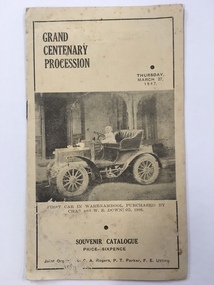
Booklet, Grand Centenary process, 1947
... was the year of the first land sales for Warrnambool and the arrival... was the year of the first land sales for Warrnambool and the arrival ...This is a program of the Centenary Procession that took place in Warrnambool in 1947 to celebrate the 100th anniversary of the city’s founding in 1847. It was originally intended to celebrate the 100th anniversary in 1940 but these celebrations were postponed because of World War Two. In 1947 centenary celebrations were held but on a less lavish style. 1947 was a more appropriate year as 1847 was the year of the first land sales for Warrnambool and the arrival of the first European settlers in the town. The 1947 celebrations included a Grand Procession which was estimated to have been watched by 20,000 people. A similar number saw the bonfire and fireworks display in Albert Park the same evening. The celebrations lasted a week and included a choral thanksgiving festival in the Botanic Gardens, a massed band display and a ‘Warrnambool Can Make It’ exhibition of local manufactures. The well-known historian and Town Clerk at the time, Henri Worland took a prominent role in the organizing of the celebrations. This little booklet is of considerable importance because it contains a short description of the floats and the names of those connected with the various floats of the Warrnambool Centenary Procession of 1947. It not only gives us a better idea of what and who were in the procession but it now enables us to better label the many photographs we have of this procession and to identify the people in the photographs. The program is a valuable source of information for historians. It also is a good example of the type of celebratory procession that was popular 70 years ago. This is a paper program of the Warrnambool 1947 Centenary procession. It has four pages and a buff-coloured cover. The front cover has a sepia-toned photograph of the first car purchased in Warrnambool (1906) and on the back cover there is an advertisement for Lane’s Bus Services. The inside front cover has an advertisement for Guyett and Sons Furniture Store and there are other advertisements throughout the pages. The printed text on buff-coloured paper gives details of the 29 floats in the ‘Mechanized’ Section and of the 27 floats in the ‘Back to the Horse Pageant’ Section. The pages were stapled but the staples have been removed. There has been some silverfish damage. Front Cover: ‘Grand Centenary Procession, Thursday, March 27, 1947, Souvenir Catalogue, Price Sixpence, Joint Organisers, C.A.Rogers, P.T.Parker, F.E.Utting’. warrnambool centenary, 1947 henri worland -
 City of Moorabbin Historical Society (Operating the Box Cottage Museum)
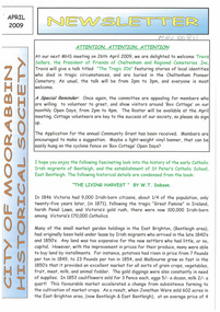
Newsletter, City of Moorabbin Historical Society Apr 2009, April 2009
... Survey or Brighton Estate showing the Land Sales of Lot 2, & 3... Survey or Brighton Estate showing the Land Sales of Lot 2, & 3 ...The City of Moorabbin Historical Society was formed c 1960 by a group of Moorabbin residents who were concerned that the history of the area should be preserved. A good response to a call for items related to the historical area of Moorabbin Shire brought donations of a wide variety of artefacts which are now preserved by the current members of CMHS at Box Cottage Museum . Helen Stanley, Secretary of CMHS, began producing a Newsletter for members in April 2007 to provide current information and well researched items of historical interest.Helen Stanley has produced a bi-monthly Newsletter, 2007 - 2013, for the members of the City of Moorabbin Historical Society that contains well researched interesting historical items, notification of upcoming events, current advice from Royal Australian Historical Society , Museums Australia Victoria and activities of Local Historical Societies. The Newsletter is an important record of the activities of the CMHS.2 x A4 paper printed on 4 sides Issue 11 of the bi-monthly, City of Moorabbin Historical Society Newsletter produced by Society member and Secretary, Mrs Helen Stanley in April 2009. Notice that Mr Travis Sellars, Friends of Cheltenham and Regional Cemeteries, will talk about ‘The Tragic 20’s’ at the meeting April 26th . Volunteers are needed to show visitors around on Open Days each month and a Roster will be made on April 26th . Suggestions are requested for the Community Grant Application to be submitted by CMHS. Historical details are condensed from ‘ The Living Harvest’ by W.T Dobson, describing the establishment of St. Peter’s Catholic School East Bentleigh 1865 on land donated by Fred Quinn , in Centre Road, East Brighton ( East Bentleigh). A photo copy of Parts of Country Portion 39 of Dendy’s Special Survey or Brighton Estate showing the Land Sales of Lot 2, & 3 North Road and Jasper Road 1841 – 1869. Interesting note on the origin of ‘Jasper Road’. 3 photocopied photographs of St Peter’s School building 1903, School Children at East Brighton Railway Station, 1903, A Lorry in the parade 1903. CITY of MOORABBIN HISTORICAL SOCIETY / APRIL 2009 NEWSLETTERcity of moorabbin historical society, stanley helen, dobson w.t., melbourne, moorabbin, brighton, friends of cheltenham and reional cemeteries, cheltenham, ormond, bentleigh, market gardeners, irish immigrants c1850pioneers, early settlers, moorabbin shire, box cottage museum, port phillip bay, brighton estate, jasper road ormond, east boundary road brighton, dendy’s special survey 1851, point nepean road, south road brighton, thomas street brighton, north road brighton, county of bourke, box h., box william, parish of moorabbin, parish of prahran, markets, shingle roof, weather-board, mr., mckinnon, were jonathan, niall rev. fr. patrick, quinn fred, elsternwick, catholic church directory 1878, hibernian society melbourne, brady peter., kennedy mr., boland mr., leary mr., gahan mr., archbishop carr, rev. fr. gough., presentation convent gardenvale, sister mary vincent, charlston john, bavarian dress band, hales jasper -
 Kew Historical Society Inc
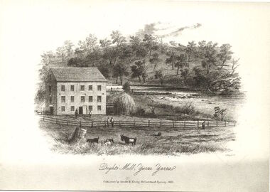
Print, Dight's Mill, Yarra Yarra
... at the Port Phillip land sales held in Sydney. Dight was already... land sales held in Sydney. Dight was already in the business ..."In 1839 John Dight purchased Melbourne block 88, which included 26 acres of land along the Yarra River for £481 at the Port Phillip land sales held in Sydney. Dight was already in the business of flour milling and had a mill near Campbell Town in New South Wales called ‘Ceres’. In April 1840, he notified his customers through The Sydney Herald that he was leaving to go to Port Phillip. The first steam powered flour mill was constructed in Melbourne in 1841. Dight built his water powered mill, soon after, from bricks bought over from Tasmania. Dight used the river to power his mill: Water flowed along an inlet channel to turn an undershot water wheel. In order to regulate flow or to ensure flow for times when river levels were low, Dight constructed a rough stone weir. " (https://www.melbournewater.com.au/whatwedo/projectsaroundmelbourne/Documents/A_Short_History_of_Dights_Falls_Fact_Sheet.pdf) This work forms part of the collection assembled by the historian Dorothy Rogers, that was donated to the Kew Historical Society by her son John Rogers in 2015. The manuscripts, photographs, maps, and documents were sourced by her from both family and local collections or produced as references for her print publications. Many were directly used by Rogers in writing ‘Lovely Old Homes of Kew’ (1961) and 'A History of Kew' (1973), or the numerous articles on local history that she produced for suburban newspapers. Most of the photographs in the collection include detailed annotations in her hand. The Rogers Collection provides a comprehensive insight into the working habits of a historian in the 1960s and 1970s. Together it forms the largest privately-donated collection within the archives of the Kew Historical Society.An engraving of Dight's Mill on the Yarra. The image was originally published in Sands & Kenny, Melbourne & Sydney. Dorothy Rogers reproduced the print in 'A History of Kew' (1973). It faces page 8.Published by Sands & Kenny, Melbourne & Sydney, 1856dight's mill, dorothy rogers, dight's falls, yarra river, kew, john dight -
 Kew Historical Society Inc
Print, Sands & Kenny, Dights Mill, 1856
... at the Port Phillip land sales held in Sydney. Dight was already... land sales held in Sydney. Dight was already in the business ..."In 1839 John Dight purchased Melbourne block 88, which included 26 acres of land along the Yarra River for £481 at the Port Phillip land sales held in Sydney. Dight was already in the business of flour milling and had a mill near Campbell Town in New South Wales called ‘Ceres’. In April 1840, he notified his customers through The Sydney Herald that he was leaving to go to Port Phillip. The first steam powered flour mill was constructed in Melbourne in 1841. Dight built his water powered mill, soon after, from bricks bought over from Tasmania. Dight used the river to power his mill: Water flowed along an inlet channel to turn an undershot water wheel. In order to regulate flow or to ensure flow for times when river levels were low, Dight constructed a rough stone weir." (Melbourne Water)Dights Mill. Reproduction of a book plate from an original wood engraving, showing Dights Mill and Falls on the River Yarra. The image was originally published in Sands & Kenny, Melbourne & Sydney.Annotation on reverse: "Dights Flour".dights mill, yarra river -
 Bendigo Historical Society Inc.
Document - INDEXES
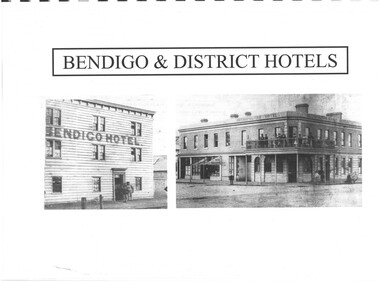
... and District Compiled by Len Bennetts Sandhurst Land Sales 1854 – 1856... and District Compiled by Len Bennetts Sandhurst Land Sales 1854 – 1856 ...Indexes Includes Names from the 1856 Petition Bendigo and District Hotels Final Marunari List Terry Davidson 1871 - 2018 Index to RHSV Bendigo Branch Newsletters Nov. 1971 - July 2002 Helen Mainka 1954 Bendigo Business District Directory McConnell’s Street and general Directory Date unknown Victorian Directory 1904 Bendigo and District Directory 1904 – 1905 Bendigo district general Directory 1859 City of Bendigo Historical Information Bendigo Hotels compiled by Len Bennetts Hotels of Bendigo and District Compiled by Len Bennetts Sandhurst Land Sales 1854 – 1856 Ralph Birrell Chronicles of Bendigo from the Bendigo Advertiser Christmas Supplement December 22 1904 Some Photographers 1850 – 1900. Including some Bendigo Photographers 1854 – 1958 St. Patrick’s Annual Sports advertisers. Date Unknown Fatalities listed in bendigo Advertiser 1888-1935. Two copies One by year. One alphabetical. District statistics - Mayors and Shire Presidents, Bendigo Football League Premiers 1880- 1987, Sportstar of the year 1965-1987 Plans of townships and Parishes held at Ducley House. From the Bendigo Lands Office 1976. -
 Melbourne Tram Museum
Ephemera - Timetable, Hawthorn Tramways Trust (HTT), "Directory and Tramway Guide issued by the Hawthorn Tramways Trust", 1918
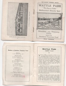
... for land sales at Riversdale Heights estate. Advertisements... on the trams, and a map for land sales at Riversdale Heights estate ...Booklet - 38 pages, printed on off white page, centre stapled, titled "Directory and Tramway Guide issued by the Hawthorn Tramways Trust", specifically advertising Wattle Park and showing Princes Bridge and the Yarra on the front cover and a photo of Hawthorn depot on the rear cover. Gives details of Wattle Park, its opening, many photos, members of the Trust, Engineer and Manager and Acting Secretary, Stopping points for the round and fares to Wattle Park, section fares, maps of the tram routes and connections with other tramways and railway stations. Has timetables for Burnley and other major points, special and emergency services, the coloured lights used on the trams, and a map for land sales at Riversdale Heights estate. Advertisements for Mutual stores, Melbourne Electric Supply Co., Moule, Hamilton and Kindle for the sale of land at Riversdale Heights and a map showing the estate location. Both copies have alterations or corrections to the route signage letters - marked in red - from the Minutes of the HTT Board meetings, the Trust were not happy with the finished product and was reluctant to pay for them - see Minutes of Meeting No. 99 of 5-7-1918. Two copies held - one with red marks on the front cover.trams, tramways, htt, wattle park, princes bridge, hawthorn depot, timetables, mesco, real estate -
 Eltham District Historical Society Inc
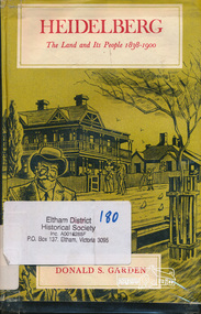
Book, Melbourne University Press, Heidelberg: The Land and its People 1838-1900 by Donald S. Garden, 1972
... the suburb to be born " - flyleaf. Contents: First land sales... the suburb to be born " - flyleaf. Contents: First land sales ...Although Heidelberg was one of the first parts of the Port Phillip District to be settled, and became important and prestigious in the early years of the colony, its history has been largely neglected. The beauty and fertility of the land and its proximity to Melbourne quickly resulted in the establishment in the 1830s and 40s of large estates by wealthy gentlemen. A romantic spot, Heidelberg became popular with picnickers and later attracted an artists' colony. The character of the area then gradually changed as a distinct village community emerged, and market gardens began to flourish. Unlike some of the suburbs closer to Melbourne, Heidelberg eventually wilted under economic pressures from which it did not fully recover until the turn of the century. This book allows us within the larger contect of the colony's fortunes and misfortunes, the struggle of Heidelberg the suburb to be born " - flyleaf. Contents: First land sales and subdivisions, gentlemen of Heidelberg and their estates and activities, infant rural community. golden fifties, decline and backwater, railway and land boom, a maturing community , the depression of the nineties. This book was the first to focus on the area of Heidelberg and its context within the Port Phillip District and remains significant as a key secondary source for describing the history of the area. It is relevant to the contextual history of its neighbour the former Shire of Eltham and Shire of Nillumbik.Hardback. Includes illustrations and index, 219 p.ISBN 0522840191port phillip district, ivanhoe, heidelberg, charles wingrove -
 City of Moorabbin Historical Society (Operating the Box Cottage Museum)
Document, laminated photocopy of 'Plan of Moorabbin 1850', 1853
... the land at 1pound per acre. Land Sales proceeded from 1844... at 1pound per acre. Land Sales proceeded from 1844 as more ...Weston Bate, 'A history of Brighton' 1962 informs us that in 1840 Henry Dendy, who was a farmer in Sussex England, paid 5,120 pounds sterling @ 1pound per acre for a 'Special Survey of Land in Port Phillip , Australia. Henry arrived in Australia in 1841 on the frigate 'York' with his wife, son, and three servants. He also took advantage of the Government Assistance of Free Immigrants for Survey Purchasers, to help on his estate and persuaded some Sussex men with their families to follow him. However when Dendy arrived in Port Phillip he found that LaTrobe and Gipps were trying to raise the price of land close to Town to 15pounds per acre. Dendy asked merchant J.B.Were to manage his affairs and they went ahead with plans to subdivide the surveyed land called 'The Brighton Estate' This area of land extended easterly from the Port Phillip Bay to East Boundary Road and from North Road to South Road in the Parish of Bourke Victoria. The Privy Council, England , decide that Henry Dendy could purchase the land at 1pound per acre. Land Sales proceeded from 1844 as more immigrants established market gardens, farms and varied businesses in 'Moorabbin'This is a photocopy of a Map of the Moorabbin , County of Bourke c1850 showing the 'Henry Dendy Special Survey 1841'A photocopy of a Map of the Moorabbin , County of Bourke c1850. A3 size laminatedLeft corner : MOORABBIN / COUNTY OF / BOURKEdendy henry, dendy special survey 1841, brighton, moorabbin, ormond, bentleigh, market gardeners, pioneers early settlers, box william, box elizabeth -
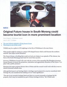 Greensborough Historical Society
Newspaper Clipping - Digital Image, The Whittlesea Post, Futuro House Greensborough, 2017, 02/07/2017
... in Greensborough as a temporary booth for sales of land at a new housing..., but previously used in Greensborough as a temporary booth for sales ...Written in 2017, this article reports on the history of the Futuro House, now in South Morang, but previously used in Greensborough as a temporary booth for sales of land at a new housing estate called Apollo Parkways.Digital copy of newspaper clipping, black text and colour image.futuro house, apollo parkways -
 Narre Warren and District Family History Group
Booklet, Narre Warren & District Family History Group Inc, Casey Cardinia Collection - Nar Nar Goon Information File, 2005
... in 1844, followed by land sales in the 1850s and 1860s. Many... in 1844, followed by land sales in the 1850s and 1860s. Many ...Nar Nar Goon, a town in Gippsland, Victoria, has a rich history dating back to the mid-19th century. Originally part of the Kulin nation, the area was home to the Boon Wurrung people. The name "Nar Nar Goon" is believed to come from a Boonwurrung word referring to either the koala or the rakali. European settlement began with the establishment of the Mount Ararat pastoral run in 1844, followed by land sales in the 1850s and 1860s. Many settlers came from Ireland, particularly from the Monteagle estate in Limerick. The arrival of the railway in 1881 was a turning point, facilitating timber and agricultural industries. Several sawmills operated in the area, transporting timber via wooden tramways to the railway station. By the early 20th century, Nar Nar Goon had developed into a thriving township with a general store, hotel, butcher, baker, and garage. The town had strong Catholic roots, with a church opening in 1905. Over time, timber milling declined, and dairy farming became the dominant industry. In 2021, part of Nar Nar Goon was annexed to form the new suburb of Pakenham East. Today, Nar Nar Goon is known for its murals, historical buildings, and community spirit. It remains a small but significant town in Victoria’s history. [AI generated text]Display book containing a table of contents and various newspaper clippings and other information pertaining to the Nar Nar Goon area.non-fictionnar nar goon (vic.), nar nar goon (vic.) -- history, bernie byrne, jack egan, mark & sylvia jones, daisy lia, bill doherty, michael o'brien, joan & frank lindsay, paddy henwood, bob rose, harry james, ray coombs, jack payroll, deb bramley, nar nar goon-maryknoll cricket club, john byrne, bernie dingle, jan van steensel, len & mary bramley, kylie shanks, bill bickerton, james dore, red gem potatoes, brydie cunningham -
Glen Eira Historical Society
Article - VICTORIAN RAILWAYS
... , Railway, Land Sales and Sugar Beet ventures in Caulfield’ by D. F... to Rosstown, Railway, Land Sales and Sugar Beet ventures in Caulfield ...File contains 3 items: 1/Original handwritten notes by Leo J Harrington (VR Melbourne) and T O’Callaghan titled ‘Victorian Railways to ‘62’. Notes include dates of electrification of lines, station openings, valuations, railway station names and their origins. Reference to council minutes regarding request to change the name of Elsternwick station to Caulfield in June 1871. 2/Original newspaper article from ‘The Age’ dated 10/06/1978 by Graeme Davidson titled ‘A case study of Railway politics’. Article refers to a publication called ‘Return to Rosstown, Railway, Land Sales and Sugar Beet ventures in Caulfield’ by D. F. ‘Return to Rosstown’ recounts the story of the Rosstown Junction railway and its creator, William Murray Ross. Tells of Ross’ life since coming to Australia from Liverpool and how he prospered as a land speculator owning large tracts of land in Caulfield, the sugar mill and his plans to operate a railway. 3/Original newspaper article (and image) from ‘Moorabbin Standard’ dated 25/11/1981, titled ‘Centenary train to carry mayors’. Article reports that a special train will run from Spencer Street Station to Mordialloc railway Station on Saturday 19/12/1981 to celebrate the centenary of the railway line to Mordialloc. Story mentions that in 1881, the Caulfield to Mordialloc line was a single track and that passengers can also board the special train at Caulfield Station. Image is of steam train with red ‘tait’ carriages (undated).victorian railways, caulfield, glenhuntly, glen huntly, elsternwick, carnegie, murrumbeena, ormond, steam train, glenhuntly road, glen huntly road, ripponlea, north road, rosstown, rosstown junction railway, ross william murray, railways, trains, south caulfield, grange road, railway stations, mirrambeena, caulfield city council, sugar mill, electrification. -
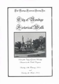 Bendigo Historical Society Inc.
Book - CITY OF BENDIGO HISTORICAL WALK BOOK, 2001
... Land Sales and streets are surveyed and named for the first... issue printed, 1854 First Land Sales and streets are surveyed ...Photocopy mock up of original booklet of The Bendigo Historical Society Inc. 'City of Bendigo Historical Walk' containing photographs of historic buildings to be seen on the walk. Front cover Queen Victorian Gardens, Town hall, Mechanics Institute/School Of Mines and Industry, H. M. Prison Bendigo, Camp Hill Police Barracks, Sandhurst Corporate High School, Central State School No. 1976, The Cascades, District Lands Office (Dudley House), Masonic Temple and Hall, Sandhurst Volunteer Rifle Brigade Orderly Room, Bank of Victoria, Henry Jackson's Store View Point,Alexandra Fountain, Beehive Store/Mining Exchange, Colonial Bank. Hustlers Royal Reserve NO. 2/R.S.L. Memorial Hall, Post Office 3rd 4th and final, Bendigo Law Courts, Shamrock Hotel 2nd and another view. Important Bendigo Dates; 1851, April gold discovered at Golden Square by Margaret Kennedy,1851 Approx. 200,000Troy oz. of gold found in Bendigo, 1852 475,857 Troy oz. Gold for the year, 1853 November 31st Bendigo Hospital admits first patient,1853 December 9th Bendigo Advertiser first issue printed, 1854 First Land Sales and streets are surveyed and named for the first time, 1854 Census of Bendigo showed 15,480 residents plus 4,000 Chinese, 1855 Sandhurst Municipal District formed, 1861 Sandhurst Proclaimed a Town. 1862 Railway to Melbourne opened, 1867 Visit by His Royal Highness the Duke of Edinburgh, 1871 July 21st Sandhurst proclaimed a City, 1881 Population of Sandhurst 14,577 residents, 1882 First telephone communications introduced, 1890 Electric trams (battery) commenced running, 1891 May 18th City of Sandhurst changes its name to City of Bendigo.book, bendigo, buildings, historic -
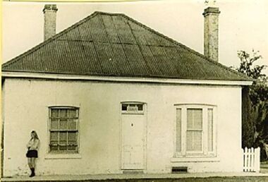 Wodonga & District Historical Society Inc
Photograph - Stonleigh, Wodonga
... on land granted to Daniel Rhodes in 1854, in one of the first land... granted to Daniel Rhodes in 1854, in one of the first land sales ...Stonleigh is one of Wodonga’s earliest buildings and stands on land granted to Daniel Rhodes in 1854, in one of the first land sales conducted in Wodonga. The building commenced soon after with the stone walls being 18 inches (46cm) thick. It was a four-room granite rubble stone building with central door and a window on either side, with a separate kitchen, as was typical of the worker's cottage of the day. The original roof would have been shingles but it was replaced with corrugated iron. It passed through several owners including Paul Huon in 1858. Peter Tenner, a farmer and vigneron took over in 1866 when it was described as “built of stone and having a cellar and a detached kitchen plus outside toilet, and a shed or two.” In the late 1880’s it was owned by William Smith who had come to Wodonga as a missionary for the Presbyterian Church and who, together with John Whan, storekeeper, was instrumental in building the Presbyterian Church nearby. Between 1890 and 1910 further buildings were added, consisting of double brick walls, two bedrooms, kitchen, laundry with brick and copper, bathroom and side verandah. William Smith established Wodonga Cordage Works in the Stonleigh buildings. The front room of the house was the display room for the business which manufactured and sold fishing lines, various types of cordage and water bags, the latter being of hand-sewn canvas. After 1954 Stonleigh became a bottle depot and bottle museum under ownership of Ramon Porta. At one stage he had over 50,000 bottles on display. In 1991 it was purchased by Mark Fraser, a cabinet maker, who made extensive renovations at the rear of the premises and internally, but left the façade untouched. Over recent times, Stonleigh was the home of several business including a florist, a patchwork maker and a café. Stonleigh was sold in 2021 and is now a private residence.These images capture one of Wodonga's oldest buildings.A series of photos, both colour and black and white, showing the building "Stonleigh' at different periodsstonleigh wodonga, old buildings wodonga, wodonga businesses, wodonga pioneers