Showing 2943 items
matching early victorians
-
 Warrnambool and District Historical Society Inc.
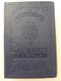
Book, Royal reader No6, 1891L
... as an early school reader for Victorian children. Used in the 1890s ...This is a school reader used in the 1890s by Maggie Glasgow at Wangoom State School. This school opened in 1865 on the Warrnambool/ Wangoom Road as a Common School but it is now closed. Maggie Glasgow is probably Margaret Glasgow (1880-1954), the daughter of John and Esther Glasgow who were dairy farmers and cheese makers at Blackwood Hill, Wangoom. Jean Glasgow was the daughter of William and Isabella Glasgow who lived in the same area. The Warrnambool and District Historical Society has in its collection examples of the Glasgow butter moulds. This book is of interest as an early school reader for Victorian children. Used in the 1890s this book has some Australian content. The Glasgow children that used this book are members of the Glasgow families important at the turn of the 19th century as cheese makers in the Warrnambool district. This is a hard cover book of 400 pages. Several pages are missing. The cover is dark blue with ornamental patterning on the front and embossed lettering. The text contains many black and white illustrations, some of which have been coloured in by hand. The inscriptions and other written material have been handwritten in black ink and pencil. The pages are partly detached from the binding. ‘Maggie Glasgow, State School No. 645 Wangoom, 31/5/95’ (written twice) ‘Jean Glasgow’ ‘Dear old Mag’ ‘Isie wants a half holiday because L.W. got 20 for English’ maggie glasgow, jean glasgow, history of warrnambool -
 Warrnambool and District Historical Society Inc.
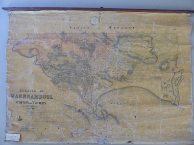
Mao, Borough of Warrnambool, County of Villiers, 1873
This is an early map of the Borough of Warrnambool (1872/3) showing the central town area of Warrnambool and the surrounding district. Reserves, public buildings and some businesses are marked. The map was photolithographed by John Noone, a Melbourne artist and photographer who claimed in 1858 to have the oldest-existing photographic studio in Melbourne. Photolithography was a process first developed in Melbourne. For several years Noone was the official photographer for the Victorian Crown Lands Office and for the Victorian Public Library and Museum. The map has the stamp of the seller of the map – Charles Hider, the well-known stationer and bookseller in Timor Street, Warrnambool. The owner of the map, Henry George Marfell, (1883-1962) was the son of John and Mary Ann Marfell. The Marfells were well-known in Warrnambool as grain merchants and managers of the Warrnambool Co-Operative Milling Company. It is surmised from the writing on the Marfell label that this map was at some stage given by Henry Marfell to the old Warrnambool MuseumThis map of early Warrnambool is of considerable significance, firstly because its original state and early date (1873) make it of antiquarian and historical interest. Also the connection with the names, Charles Hider and Henry Marfell and the old Museum gives it added provenance and interest.This is a wax paper map mounted on cloth. At the top it is attached by nails to a piece of wood and at the top it has a cloth ring for hanging the map. The map is in black shadings on a yellow background. The map is badly creased and coming away from the cloth at the edges and at other various points. There is some red or pink marking or staining on the township area of the map (originally the sold lands on this map were coloured in brown and the reserves, buildings, etc in pink). On the left hand corner there is a piece of paper glued on with some handwriting in ink (Marfell). There is also the stamp of the seller of the map – Charles Hider, stationer and bookseller, of Timor Street Warrnambool‘Early Map of W’bool, H.G. Marfell’ history of warrnambool, charles hider, henry marfell -
 Warrnambool and District Historical Society Inc.
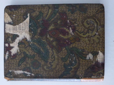
Book, The Victorian Reading book - first edition, 1928 (first edition)
This is a first edition copy of the Victorian School Readers (Eighth Book) issued by the Education Department of Victoria. These readers were first published in 1928 and became standard texts for all school children up to Year Eight. They complemented the School Paper which had been published monthly for different year levels since the end of the 19th century. Both the Readers and the School Papers were in widespread use until the late 1940s and the early 1950s. William McCullagh and his wife Margaret had the property Oak Grove at Yangery at the end of the 19th century and in the early decades of the 20th century. Yangery is an agricultural area situated between Woodford and Koroit. There is a record of Silvie Jean McCullagh (parents – William and Margaret) born in 1914 and this is probably the person who owned and used this reader. This book is of interest not only because it is a first edition copy of one of the well-known Victorian School Readers but also because it was connected to the McCullagh family of Oak Grove, Yangery. This is a hard cover book of 260 pages. The cover was originally a burnished brown colour but the book has been covered with a mottled patterned cloth material (red, green and brown). The cover is partly torn off at the bottom of the spine. The book has poetry and prose extracts and includes many black and white sketches, maps, photographs and illustrations. The inscription and some other annotations throughout the book are handwritten in pencil. ‘Sylvia McCullagh, Oak Grove, Yangery, Dennington P. Office’ history of warrnambool, oak grove, yangery, mccullagh family, school readers -
 Warrnambool and District Historical Society Inc.
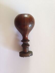
Functional object - Seal: Woodford Mechanics Institute, 19th century
Mechanics Institutes were first established in the 19th century in Scotland and England to improve the education of working class men and to instruct them in their various trades. In Australia Mechanics’ Institutes were set up in the late 1920s with the first one in Melbourne dating from 1839. The Institutes in Victoria were (and some still are) a feature of Victorian country towns, usually consisting of a hall containing a Library and in bigger centres art class rooms and other recreation areas. The Woodford Mechanics’ Institute was established in 1861, enlarged in 1868 and burnt down in 1917.This seal is of major interest as it is the only seal we have of Mechanics’ Institutes in our district. These Mechanics’ Institutes were very important in the educational and social development of Victorian country towns. This is a seal or stamp made of brass and attached to a wooden handle. The wood on the handle is of a dark colour and is urn-shapedStamp - Woodford Mechanics Institutemechanics’ institutes, woodford, early mechanic institute seal -
 Warrnambool and District Historical Society Inc.
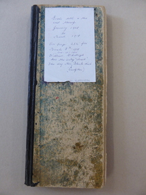
Ledger, Alex Black Painter & Decorator 1908-1918, Circa 1908
Alexander Black was a painter and decorator who operated a business in Timor St below Swinton’s. This ledger shows the items typically sold by the painting and decorating trade as well as names of local people and businesses such as T Redford, PJ McGennan, Smith Bakery, Sheldrick Brewery, and Co, Mr. Plowright and Victorian Railways and Gas works.This ledger provides a snapshot of daily life in the early 1900’s and documents the type of work completed by tradesman and their associated costs. It lists a number of people and organizations which are of historical interest to Warrnambool and district.Long thin rectangular ledger book. Worn dark aqua cardboard cover with black binding. Handwritten entries occupy three quarters of the ledger with line drawn through each entry. The entries relate to goods sold. Year written at top of page and dated in left hand column. warrnambool, warrnambool painters and decorators, black painters warrnambool, -
 Warrnambool and District Historical Society Inc.
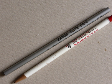
Pencil, Souvenir Pencil x 2, 1960s
These two pencils have been marked with names to serve as advertising items and souvenirs. One is from Zanos’ Elite Café of 80 Liebig Street. This café operated in the 1950s and 60s. The other is from the Jaycee 20th Victorian Zone Conference of 1965 held in Warrnambool. The Warrnambool Junior Chamber of Commerce (Jaycees) was established in the early 1950s to advance business and encourage civic leadership in its members. The Briquette Company was a sponsor of the 1965 Conference.These pencils are of minor interest as examples of advertising techniques used in the second half of the 20th century. Today the souvenir item is more likely to be in the form of a biro or a computer accessoryThese are two circular lead pencils, one advertising Zanos’ Elite Café, which is unsharpened and silver in colour and one advertising the Jaycee 20th Victorian Zone Conference of 1965 and Briquettes which is of white and red colouring.1. ‘Zanos’ Elite Café, 80 Liebig Street, Warrnambool, Phone 2236’ 2. ‘ Jaycee 20th Victorian Zone Conference, Warrnambool, 1965, Bernie Briquette says- Enjoy the Friendly Warmth of Briquettes’ zanos’ elite café, warrnambool jaycees, warrnambool -
 Warrnambool and District Historical Society Inc.
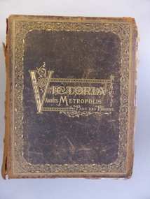
Book, Victoria & Its Metropolis Vol 1 & 2, 1888
These two volumes are seminal historical writings published in 1888. The author of Volume One is Alexander Sutherland (1852-1902), described as ‘a forgotten Australian intellectual’. Born in Scotland, Sutherland was a teacher, poet, biographer, novelist, scientist, philosopher and journalist. In 1902 he was the Registrar of Melbourne University and he was the Secretary of the Royal Society of Victoria. With his brother, George, he wrote a history of Australia and New Zealand which sold 100,000 copies, the first best-selling Australian history. His book, ‘The Origin and Growth of the Moral Instinct’ influenced Russian philosophical thought. This is a most significant book as it contains short biographical notes on a great number of early (19th century) residents of the Warrnambool district. As well as listing information on Warrnambool identities it includes information on residents of Purnim, Wangoom, Dennington, Panmure, Garvoc, Framlingham, Winslow, Yangery, Woodford, Mailors Flat, Grasmere, Bushfield and Allansford. It is a great resource for researchers today. The two volumes also contain illustrations pertaining to the areas around Warrnambool and are of great historical as well as artistic interest. These are two volumes of ‘Victoria and Its Metropolis’. They are leather bound with a black cover, heavily ornamented in gold around the edges of the cover and with the printed material also in gold lettering in an ornamental pattern. The spine of the covers are brown with gold ornamental patterns and printing. Volume One has 594 pages with 258 illustrations , all black and white and this volume contains writings on the early days of the colony up to 1888 and chapters on the arts, churches, education, industries, science etc. in Victoria. Volume Two has 822 pages with many black and white illustrations and chapters on the regions in Victoria and biographical notes on the pioneer settlers of these districts. Both volumes are in a very tattered condition with many loose pages and the leather binding much torn and with some parts missing. Volume One cover: ‘Victoria and its Metropolis, Past and Present’ Volume One spine: ‘Victoria and its Metropolis, Vol. 1’ Volume Two Cover: ‘Victoria and its Metropolis, Past and Present’’ Volume Two Spine: ‘Victoria and its Metropolis, Vol. 2’ 19th century victorian history, victorian pioneer settlers, alexander sutherland -
 Warrnambool and District Historical Society Inc.
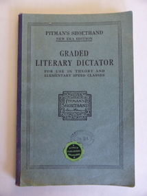
Book, Graded Literary Dictator, Early 20th century
This book contains passages from literature for use in the teaching of Pitman’s shorthand. Isaac Pitman (1813-1897) was an English educator who invented in 1837 the shorthand system named after him. Pitman’s shorthand was the most widely used shorthand system in the 19th century and early to mid 20th century. Pupils studying commercial subjects learned Pitman’s shorthand until it was replaced in the second half of the 20th century in Victorian State schools by Dacomb’s shorthand system. No information has been found on D. Vickers.This book is of interest as an example of the type of shorthand tcxt books used early in the 20th century. It is useful for display.This is a soft cover book of 63 pages. It has a green cover with blue binding and black printing on the front cover with a printed signature of Isaac Pitman enclosed by an ornamental border. The back page has printed information about other Isaac Pitman books. The front cover has a circular black and green label pasted on. The pages are slightly detached from the binding. The inscription is handwritten in black ink and pencil.‘D.McK. Vickers’ pitman’s shorthand, history of education -
 Warrnambool and District Historical Society Inc.
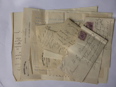
Documents, Parrington, 1896-1897
These documents concern the 19th century proposed sale of the legal practice of Henry Parrington of Warrnambool to Samuel Backhouse of Collins Street, Melbourne. Samuel Backhouse came to Warrnambool to inspect the Parrington practice and offered £750 for the practice. The offer was accepted and the contract for the sale was drawn up. Henry Parrington then withdrew from the sale and was sued by Backhouse for breach of contract. Backhouse was wanting £150 compensation. The outcome of this case is not known. Henry Roberts Parrington qualified as a lawyer in England in 1873 and worked as a barrister and solicitor in New Zealand from 1876 to 1886. He then came to Australia and worked for the legal firm of Messrs Higgins in Geelong and for Bayly and Higgins in Warrnambool. The business in Kepler Street, Warrnambool later became known as Higgins and Parrington and, in 1900, as Parrington and Tait (partner John Sym Tait). When John Tait retired in 1901 Henry Parrington was the sole proprietor of the practice. He died in Melbourne in 1926. These documents are of considerable interest as they outline an episode in the life of Henry Parrington, a well-known lawyer in Warrnambool in the late 19th century and the early 20th century. These are eleven documents pertaining to the Warrnambool lawyer, Henry Parrington. There are four single-sheet letters – two have blue typing and two have handwritten material in black ink. There is one telegram with both printed and handwritten material and a Post Office stamp. There are two envelopes which have been sent by mail and which have mauve Victorian twopenny stamps. These envelopes are torn at the top. These envelopes contain letters which have printed material at the top of the sheets and handwritten material in black ink. samuel backhouse, henry parrington, history of warrnambool -
 Kiewa Valley Historical Society
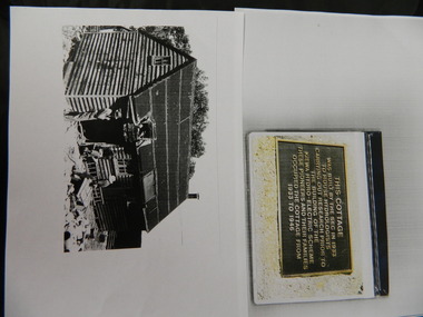
Wilkinson Lodge - copies of 6 photos, 1 plaque, 1 article
Wilkinson's Hut was built for the State Electricity Commission of Victoria in 1932 as a permanent residence for the snow research program manager, who was the resident engineer of the Kiewa Hydro Electric Scheme. The hut was sold in 1948 to the Ski Club of Victoria / Victorian Alpine Club and renamed Wilkinson Lodge. In 1958 it was sold to the Melbourne Bushwalkers Club. It was burnt down on 17th January 2004.Wilkinson Lodge was located at Wallace Gap on the Bogong High Plains and was the first S.E.C.V. permanent residence for the workers of the Kiewa Hydro Electric Scheme. It is also an early built lodge owned briefly 1946 - 1958 by the Ski Club of Victoria / Victorian Alpine Club and used by skiers before other lodges were built at Falls Creek. It was used by bushwalkers until it was burnt down thus in itself depicting part of the history of the area.5 pages of copies of photos of Wilkinson Lodge, 1 page of a copy of the destruction of Wilkinson Lodge (6 small photos), 1 page of a copy of a plaque titled 'This cottage' and 1 page of an article from the Border Mail (newspaper) dated 19th Jan. 2004.wilkinson hut; secv; ski club of victoria; melbourne bushwalkers club; fire -
 Kiewa Valley Historical Society
Photograph - Mt Beauty Community Centre original colour plan and photos of upgrade in 2000, 1. Dated March 22nd, 1962 2. Photographs taken during renovations in 2000
The Community Centre was built in the early 1950’s as an all-purpose hall for the social and recreational use of the workers and families employed on the Victorian state government Kiewa Hydro-electric scheme. The hall was originally called Mt Beauty Recreation Centre and later changed to Mt Beauty Community Centre. It has been the heart of the community for over 65 years and had a heritage listing put on it around the year 2000. The Alpine Shire secured a heritage grant and the hall was restored to its former glory in 2000. In heritage circles it is claimed that the hall is the best example of a 1950’s construction town community hall, which is still functioning anywhere in AustraliaThe Community Centre was and is a very important part of life in the small remote community of Mount Beauty and a range of activities have taken place in the Community Centre over the past 65 years- Picture theatre; Dances and balls; A physical education and boxing club run by Alex McCollough for 30 years; School and social club concerts; Girls gymnastics; Drama group productions, revues and pantomimes; Callisthetics and ballet; Badminton; Wedding receptions and birthday parties; Music festival events; Staging area in times of natural disaster; The library for many years; Shire and community meetings; Secondary College gymnasium for many years and shelter for the Community Market in inclement weather 1 – 1972 specifications for colour scheme of original Mt Beauty Recreation centre, Typed on buff foolscap paper with small colour swatches and letter of explanation to Mr A.J. McCullough. 2 – Set of 10 colour photographs of the upgrade and extension to Mt Beauty Community Centre undertaken in 2000. Photos mounted 2 to a page on blue copy paper. 3. Second copy of No.1 above. Also - typed A4 sheet re history of "The Mount Beauty Community Centre"1 – Header on pages-Mate’s Colour Bar Personal Colour Scheme for Recreation Centre Mt Beauty Vic. 21/3/62. Accompanying letter to A.J McCullough signed by Colour Consultant Ena Chatuein 2. First page of photos, written in black felt marker – Mt Beauty Community Centre 30/11/00 mt beauty, community centre -
 Kiewa Valley Historical Society
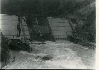
Photograph - Kiewa River in flood at Clover Dam
As part of the push to cut electricity costs and diversify supply, the Victorian Government (circa 1930) implemented the conversion strategy from mainly brown coal supply to hydro - electricity. The Kiewa Hydroelectric Scheme became the largest scheme of its kind in the State Of Victoria and the second largest scheme in Australia. Clover Dam and Power Station were built by the State Electricity Commission of Victoria as part of the Kiewa Hydro Electric Scheme from the late 1930's to the early 1940's. This dam was constructed to supply water to feed four turbines (62 mega watts) at the West Kiewa Power Station. This was at the forefront of sustainable "Green" energy. Costs associated with power supplies is still a major incentive of governments, however environmentally friendly alternatives such as wind and nuclear have also made inroads. The Kiewa valley and its surrounding alpine catchment were looked at(Victorian State Government), from the beginning of the twentieth century as a source of alternate power for an ever-increasing demand for electricity by growing population and heavy industrial areas within Melbourne City and State regions. Construction of dams, such as Clover Dam provided the large quantity holding areas of water required to turn the turbines at the various power stations to provide the electricity needed. The impact of these controls by moderating water run-off from the alpine regions is beneficial in reducing flooding from thawing of snow on the alps. This by-product allows agriculture and grazing to be less vulnerable to seasonal flooding thereby resulting in a more stable annual production level.Black and white photograph of Clover Dam with Kiewa River in flood. .5mm white boarder on 3 sides of photo.Handwritten on back of photograph in black pen - Kiewa in flood. Clover Dam.clover dam, secv -
 Kiewa Valley Historical Society
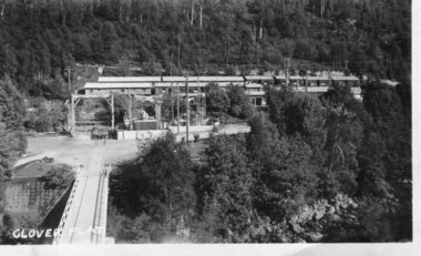
Photograph - Clover Dam
As part of the push to cut electricity costs and diversify supply, the Victorian Government (circa 1930) implemented the conversion strategy from mainly brown coal supply to hydro - electricity. The Kiewa Hydroelectric Scheme became the largest scheme of its kind in the State Of Victoria and the second largest scheme in Australia. Clover Dam and Power Station were built by the State Electricity Commission of Victoria as part of the Kiewa Hydro Electric Scheme from the late 1930's to the early 1940's. This dam was constructed to supply water to feed four turbines (62 mega watts) at the West Kiewa Power Station. This was at the forefront of sustainable "Green" energy. Costs associated with power supplies is still a major incentive of governments, however environmentally friendly alternatives such as wind and nuclear have also made inroads. The Kiewa valley and its surrounding alpine catchment were looked at(Victorian State Government), from the beginning of the twentieth century as a source of alternate power for an ever-increasing demand for electricity by growing population and heavy industrial areas within Melbourne City and State regions. Construction of dams, such as Clover Dam provided the large quantity holding areas of water required to turn the turbines at the various power stations to provide the electricity needed. The impact of these controls by moderating water run-off from the alpine regions is beneficial in reducing flooding from thawing of snow on the alps. This by-product allows agriculture and grazing to be less vulnerable to seasonal flooding thereby resulting in a more stable annual production level.Black and white photograph of Clover Dam buildings and Kiewa River. Has a .4cm white border around photograph Printed on bottom left corner of photograph in white - Clover Flatclover dam, secv -
 Kiewa Valley Historical Society
Photographs x 2 - Clover Dam, Circa 1940's
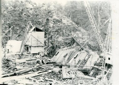
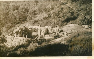
As part of the push to cut electricity costs and diversify supply, the Victorian Government (circa 1930) implemented the conversion strategy from mainly brown coal supply to hydro - electricity. The Kiewa Hydroelectric Scheme became the largest scheme of its kind in the State Of Victoria and the second largest scheme in Australia. Clover Dam and Power Station were built by the State Electricity Commission of Victoria as part of the Kiewa Hydro Electric Scheme from the late 1930's to the early 1940's. This dam was constructed to supply water to feed four turbines (62 mega watts) at the West Kiewa Power Station. This was at the forefront of sustainable "Green" energy. Costs associated with power supplies is still a major incentive of governments, however environmentally friendly alternatives such as wind and nuclear have also made inroads. The Kiewa valley and its surrounding alpine catchment were looked at(Victorian State Government), from the beginning of the twentieth century as a source of alternate power for an ever-increasing demand for electricity by growing population and heavy industrial areas within Melbourne City and State regions. Construction of dams, such as Clover Dam provided the large quantity holding areas of water required to turn the turbines at the various power stations to provide the electricity needed. The impact of these controls by moderating water run-off from the alpine regions is beneficial in reducing flooding from thawing of snow on the alps. This by-product allows agriculture and grazing to be less vulnerable to seasonal flooding thereby resulting in a more stable annual production level. Photographs also document early engineering and building techniques used in the construction of dams and power stations during the 1940’s and 1950’s. Note the lack of safety equipment and suitable work attire worn by construction workers on the sites 1. Black and white photograph of Clover Dam under construction. Has a .5cm white border around photo 2. Black and white photograph of Clover Dam under construction showing workmen at work. Has a .5cm white border around photo Written in pencil on back of both photographs - Clover Damclover dam, secv -
 Kiewa Valley Historical Society
Photograph - Building of Myrtleford Ski Club
Myrtleford Ski Club is a non-commercial, family friendly club. It was one of the earliest lodges to be built at Falls Creek and was one of the earliest ski clubs formed and celebrated its 75th anniversary in 2013. In 1949, Myrtleford Ski Club obtained permission for occupancy and began planning the MSC Lodge. There were only three other huts on the mountain, Bogong Ski Club in an old Army hut, Skyline as the Ski Club of Victoria lodge and the Albury Ski Club lodge. The lodge was built mostly from donated materials. The basement was dug out and lined with stone from the Ruined Castle area, timber was cut (using cross-saws) from the Walpole properties and was milled then carted up to Falls Creek on either the Walpole or Calvert trucks. The iron on the roof was originally a tobacco kiln on Billy McNamara's property. The lodge has undergone many improvements over the years including a second storey added in the 1950’s, updating of accommodation, shower and toilet facilities to meet the changing needs of members. The lodge now caters for 38 people in a variety of shared rooms from two to eight beds per room. Toilet and shower facilities are also shared. The club has a Lodge Managers for the winter season. Myrtleford Ski Lodge was one of the earliest ski lodges built in the Falls Creek area in 1938. It is an excellent example of early sporting and community activities in the Upper Kiewa Valley area. Photograph shows family members, including women, involved in the construction.Sepia photograph of the building of the Myrtleford Ski Club about 1948Handwritten on the back of photograph in black pen - Building Myrtleford Ski Club (about 1948) Stamped on back of photograph - 6 2511myrtleford ski club, skiing, snow sports, victorian alps, falls creek -
 Kiewa Valley Historical Society
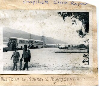
Photograph- Bus tour to Murray 2 Power Station
The Murray Region Hydroelectric Power Stations are two of seven hydro power stations, located near Khancoban in NSW. The two power stations are part of the Snowy Mountains Hydro-electricity Scheme, which is an extensive hydroelectricity and irrigation complex constructed in south-east Australia between 1949 and 1974 and now run by Snowy Hydro. Although both power stations are located in NSW, since 1 July 2008 all power generated has been allocated to the Victorian region of the National Electricity Market. Murray 2 Power Station was the first in the Snowy Scheme to use Japanese supplied large electrical and mechanical components Photographs demonstrate local Kiewa Valley residents enjoying an educational visit to Murray 2 Power Station which holds significance to the early history of the Hydro-electric Scheme in the area. Also demonstrates a pictorial history of social activities undertaken during this periodBlack and white photograph mounted on buff card Bus tour to Murray 2 Power Station showing 2 buses and group of Kiewa Valley residentsHandwritten in blue ink above photo "Snapshots Clare Roper' Handwritten in black ink below photo "Bus tour to Murray 2 Power Station'kiewa valley residents, clare roper -
 Kiewa Valley Historical Society
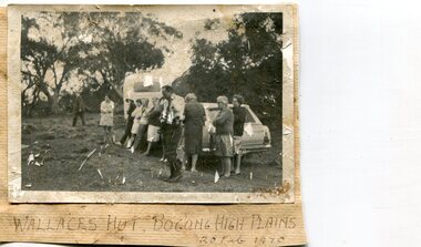
Photographs x 2- Bus tour of Wallaces Hut, 20/02/1970
Wallace's hut was built in 1889 and is probably the oldest surviving hut on the high plains of north-east Victoria. It was built in six weeks by Irish immigrant brothers Arthur, William and Stewart Wallace among old snow gums on a grassy plain above the snowline. The brothers held grazing leases on the High Plains and the hut was built to provide shelter for the cattlemen working there. It is probably the oldest hut on the Victorian high plains. It is part of the early history of hydroelectricity in the state and has links with early SEC meteorological data recording in the area Apart from its historical significance, Wallace’s Hut is a popular stop for tourists and photographers and is the starting point for the Wallace’s Heritage trail, which is a popular and well used hiking track, by locals and visitors alike.2 black and white photographs mounted on buff card. Photos taken during a bus trip to Wallace's Hut on Feb. 20, 1970 1. Group of local Kiewa Valley residents on a bus tour to Wallace's hut 2. Group of adults and children pictured outside Wallace's hut1. Handwritten in black ink on bottom of photo 'Wallace's Hut, Bogong High Plains, 20 Feb, 1970 2. No markingswallace's hut, bogong high plains, bush walking, cattlemen -
 Kiewa Valley Historical Society
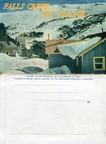
Souvenir Postcard Folder – Falls Creek Ski Village
After World War II, the Kiewa Hydroelectric Scheme was started in the Kiewa River valley by the State Electricity Commission of Victoria. On land previously used only for summer cattle grazing in the natural alpine grasslands, the first ski lodge was built in 1948 by workers from the scheme. The first lift, a rope tow, was built in 1951 and the first chairlift in Australia was constructed there in 1957. Falls Creek Post Office opened on 9 June 1958 (with telegraph and telephone facilities only until 1964) .Despite strong opposition from the head of the Kiewa scheme, who didn't want tourists clogging up his roads and destroying his "dry" construction camps by bringing in booze, Falls Creek boomed as much as Hotham, partly owing to its relatively good access road. Early lodges included Bogong (c.1946), Skyline (1947), Albury (1949), Myrtleford (1949) and Dawn (c.1950).The souvenir postcard photographed and produced by an enterprising local businessman Mr S K Pearce, was produced as a memento for skiers and other visitors to the Falls Creek and Mt Beauty area to send to family and friends as a reminder of their visit to the region, or to keep as a personal souvenir. It presented an excellent promotional opportunity for enterprising local businessmen to promote the area to skiers and tourists near and far. It also presents an excellent pictorial history of the falls creek area around the late 1950’s to early 1960’sColour postcard folder (unused) containing 13 photographs of the Falls Creek ski area and surrounds. Inside cover has a brief description of the area and the services available to visitors Printed on front cover- FALLS CREEK SKI VILLAGE. Your Souvenir Folder Photo of skiing slopes of the village Inside front flap - a brief description of the Falls Creek area and the services available to visitors 1. Diana Lodge parking area and Spion Kopje 2. Winterhaven Lodge 3. Ski Hirage Centre and skiing slopes 4. Ski Lodges from main road 5. Nelse and Arundel Lodges 6. Day visitors’ shelter and parking area 7. Summit T-Bar lift 8. Spur T-bar looking towards Village and Spion Kopje 9. T-bar lower station and Snow Crystal Inn 10. ‘Akja’ rescue sled in use 11. Falls Creek road and Grand Coeur Lodge annex 12. Rope tows and beginner slopes 13. Back cover- Published by Nucolorvue Pty Ltd Mentone Vic. Printed in Australia For S.K.Pearce Pty Ltd Tawonga and Mt Beauty falls creek, snow, bogong high plains, victorian alps -
 Kiewa Valley Historical Society
Photograph - 30 black and white photographs (assorted sizes) plus page from a newspaper and copied article on A4 paper, c1880's c1910 - 1920 (photographs) Newspaper 1961
K2,3 and4 are of the Kiewa River and two of the bridges spanning the river along the valley. K3 and K4 would have been taken in the 1880's and show the type of trees and plant growth along the river prior to land clearing for farming. K5 is of the Running Creek Cricket Team and therefore there was sufficient population in the area to form and maintain a team as well as have other teams in the relatively near vicinity to provide competition. Note the horse drawn cart which provided transport. Date taken is unknown but possibly c 1910. The Mt. Buffalo Chalet was built in 1910 by the Victorian Government. It was Australia's first ski resort and has served generations of skiiers, hikers and families over the years. It was built for 3195 pounds and has had stories and wings added since and is the largest timber building in Australia. B4 is the earliest photo in this group as the garden is in early stages of development - the other photos show the growth of the shrubs and would be taken about c 1920. Note the cars and motor bikes. It closed in 2006. The other photos are of general interest only but interesting to see that there were donkey's grazing. There is no information as to their purpose on Mt. Buffalo. Four different Kiewa Valley families are represented in the photographs. Their descendants still live in the Valley and carry on the traditions of beef and dairy farming. Of particular interest is the photo of Miss Marjorie Clemence, the first School Teacher of Upper Gundowring School. Gundowring pastoral run was taken up in 1838 and occupied by framers in the 1860's. The area was known as Gundowring and Upper Gundowring. The Gundowring School was opened in 1871 and most likely the Upper Gundowring school would be built at the same time. It was School No. 2733 and situated in Boyd Road. It closed in 1953 when the Kiewa Consolidated School opened. The newspaper page describes the activities in which the local community of Kergunyah were in engaged in that period - Red Cross, Fire Brigade, cattle round up and some of the identities involved. The article photocopied from the Yackandandah times states that he (Norman Coad) "was sent to the Ovens District Hospital, Beechworth for treatment" which would mean that this was the closest hospital to the Kiewa Valley for emergencies in 1912.The Kiewa Valley photographs are of social significance showing two of the early bridges allowing the community easy access to both sides of the river and also the tree and plant growth before land clearing for farming. The photos of Mt. Buffalo Chalet have social, architectural and historical significance. the Chalet has been used by skiers, bush walkers and day trippers since its completion in 1910 and its closure in 2006. It is listed in the Victorian Heritage Register. The family photographs are of social and historical significance as they are of early farming families in the Kiewa Valley and also depict the dress, of both men and women) in the late 1880's. The write up in the Weekly Times has social significance as it depicts the social and farming activities and photos of the local residents from around that area. The article from the Yackandandah Times is of a personal nature with concern for the individual involved. Note: There is a photo of the gentleman mentioned in the article (Mr. Norman Coad) in the Families of the Kiewa Valley (F4) as above.30 black and white photographs - 5 of the Kiewa Valley, 8 of families of the Kiewa Vallley and 17 of Mt. Buffalo. Various sized photos. Page from the Weekly times and copied article from the Yackandandah Times on A4 sheet.(Note for easier identification they have been numbered and grouped - K1-5 (Kiewa Valley), F1-8 (Families) and B1-17 (Mt. Buffalo). K1: handwritten in ink, lower L hand corner "Bogong in the distance". K2: handwritten in ink lower L hand corner "Mongan's Bridge or Towonga". K3 handwritten in ink "Taken from Mongan Bridge looking up stream". K4 - no inscription. K5: handwritten in ink, back of photo "Running Creek Cricket Team". F1: handwritten in ink on back "Mrs. Heap" and lower down in pencil "1880's". F2 handwritten in pencil at top of back phot "Land at Tawonga TROVE The Y'dah Times 20/2/1913" and lower down in ink "Henry Ellis Larkin". F3: handwritten in ink bottom edge "Mrs Coad". Note that this photo is a postcard. F4: Written in ink lower edge "Norman Coad". Note this photo is also a postcard. F5: Lower left corner in Ink "Harry Larkin". F6: lower half back of photo, in ink "Bernie Maddison". F7: on back of photograph in ink "Miss Marjorie Clemence first School Teacher Upper Gundowring: and underneath, in pencil "C1880's". F8: Handwritten in ink on back of photo "Frank & Mrs. Keat & Lesley of Tawonga". Lower down in pencil "c1912-1914". B1: Back of photo in ink "The Chalet Mt. Buffalo". B2: no inscription. B3: "chalet at Bufflo" in ink lower left corner. B4: This is a post card. Written in ink is "Mt. Buffalo Chalet". B5 - B10 printed in ink, lower left corner "Buffalo". B11: no inscription. B12: "Mt. Buffalo" lower R corner. B13: "Buffalo?". B15: Printed in ink lower edge "Picnic at Buffalo". B16: "Donkeys on Mt. Buffalo" printed in ink lower edge. B17: handwritten in ink across back of photo "Donkeys & top of Mt. Buffalo with the Monileith in the distance". A4 sheet of paper describing an accident to Mr. Norman Coad. Under article is : Yackandandah Times (Vic: 1890 - 1931), Thursday 18 July 1912, page 3. A page torn from the Weekly Times, June 14, 1961 and entitled "Kergunyah has picturesque setting". kiewa valley, farming, families, kergunyah, gundowring upper, mt. buffalo chalet, briggs family, larki family, coad family, clemence family, laskowski collection -
 Kiewa Valley Historical Society
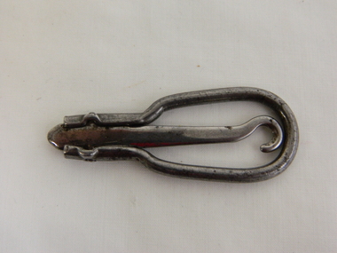
Button Hook - Folding - Clothing
Folding button hook would have been used for bringing buttons through button holes for clothing such as gloves in Victorian times. this item dates from early 1900s to 1930s.Used by resident of the Kiewa Valley.Silver metal oval surrounding a straight silver metal prong which has a hook at one end and, at the other end, is attached to the oval shape which comes in and extends as a short handle. The hook is hinged on to the oval shape enabling the hook to be pushed out creating a long tool for hooking buttons. May be used on clothing including gloves. button hook, shoes, gloves, boots, clothig, victorian, folding button hook -
 Warrnambool and District Historical Society Inc.
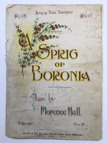
Leisure object - Sheet music, A sprig of boronia, 1916
This is an early 20th century musical composition by a leading Tasmanian composer, Florence Hull (Mrs Arthur Kenny). It is a sentimental song as the ‘sprig of boronia’ is a withered one, kept as a relic of some past event. This music was printed in the Victorian School Paper for Grades 7 and 8 in 1918 and the proceeds of copies of one of the editions of this work were donated to the Hawthorn Red Cross in Melbourne. Florence Hull’s musical works and memoirs are in the Tasmanian Archives. Paul Dufault, who sang this song, was a leading Canadian tenor who toured Australia and Europe. He died in 1930 aged 57. This sheet music has significance as it was composed by a Tasmanian woman in the early 20th century and it represents the type of music popular in concert halls at the time. It has been in the Warrnambool and District Historical Society collection for many years. This is a four page piece of sheet music (cover plus two pages of music). The paper is cream-coloured, discoloured in places, with brown print on the back of the cover and black notation on the music pages. The front cover is in brown, yellow and green tonings, with a chromolithographic illustration of a Boronia flower spray and some music bars. The back of the cover has information on eight of Florence Hull’s other compositions with comments by critics. The pages have been torn and mended with adhesive tape.Front Cover: ‘Sung by Paul Dufault’ ‘A Sprig of Boronia’ ‘Music by Florence Hull’ ‘Copyright, Price 2/- nett, Published by F. M. Kenny, Melbourne, Allan and Co. Pty. Ltd., 276-278 Collins Street, Melbourne, Adelaide, Bendigo, Geelong’ In pencil on front cover: ‘To Mac from ….., 25/8/24’ florence hull, paul dufault, warrnambool, a sprig of boronia sheet music, sheet music, warrnambool history -
 Warrnambool and District Historical Society Inc.
Document, Map: Lady Bay 1853, 1853
This is one of the earliest surveys and maps of Warrnambool harbor, Lady Bay. Being done in 1853, it shows the depths of the bay area marked in fathoms, currents and directions and areas of rocks around mouth of the Merri and the Western side of the bay as well as a large sand spit to the middle right of the beach region.. It also marks the large areas of seaweed and fuci in the outer bay area. It has the area of Pertobe Lagoon marked and shows the early tracks to the town. The engraving work was done by Tulloch and Brown, with Tulloch being one of the earliest engravers and lithographers in the state of Victoria. He arrived in Melbourne in 1849 and set up business with James Davie Brown in 1853 with Brown being a map engraver. They were awarded bronze and silver medals for their work at the Victorian Industrial Exhibition. He also worked in the vignettes on the Proeschel Map of Victoria.This map is of high historical and comparitive significance as it shows the Lady Bay area prior to the changes that have occurred in the last 160 years with the building of the breakwater. The issue regarding access to Lady Bay remains a current one. The engraver D Tulloch engraved some of the earliest scenes of the goldfields in Ballarat and as such has left a record of a very early and important era in Australian history. Rectangular cream paper with black text. Map area is outlined by fine black lined border. Key in top right hand corner and scale at bottom middle of map.Map is labelled Town of Warrnambool printed at top of map. Small logo at top right corner which has “Hydrographic Department” in circle around an anchor. Lady Bay Warrnambool Surveyed by John Barrow assistant surveyor Engraved by Tulloch & Brown in bottom right corner. Melbourne engraved by order of the legislative Council of Victoria in middle bottom.map, warrnambool, town of warrnambool map 1853, tulloch & brown map 1853, lady bay warrnambool,, warrnambool harbour, warrnambool breakwater, warrnambool beach -
 Warrnambool and District Historical Society Inc.
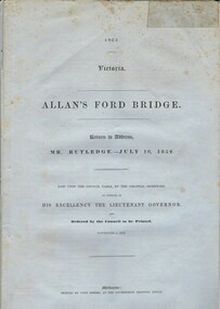
Document, Allan’s Ford Bridge 1852, 1852
This is an original Victorian Government document containing the printed version of 37 reports and letters regarding the building of the first Allansford bridge completed early in 1852. The correspondence dates from October 1850 to February 1852 and includes letters and reports from Melbourne Government employees such as Robert Hoddle, Chief Surveyor, David Lennox, Superintendent of Bridges and Lieutenant – Governor Charles La Trobe. The correspondence from local settlers included the names of William and John Allan, John Davidson and James Coulstock. The correspondence shows that some settlers in the Warrnambool/Port Fairy district wanted a portion of the Government allocated funds spent on the local roads and bridges in other locations. The 1852 Allansford bridge cost £480 and was replaced in 1870. This document has strong historical significance as it relates to one of the earliest State government works in the district and records the public imput into the decision.. It contains opinions and correspondence between a number of early settlers in the district at the time.Grey/blue paper document with black text. 21 pages plus 4 page index at back.allan's ford 1852, allansford bridge, allansford, history of allansford, warrnambool -
 Warrnambool and District Historical Society Inc.
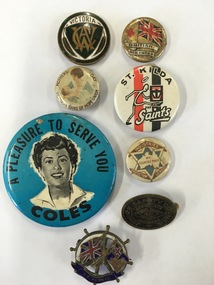
Badge - Badges x 8, Collection of various badges
These badges reflect various aspects of life in Australia and the many allegiance which people have to organisations from the Country Womans Association, to football clubs, with groups such as the Industries Protection league and Temperance groups such as the Band of Hope Union espousing interests and ideas in the early to mid 20th centurySocial significance001048.1 CWA badge Round metal badge with dark green rim surrounding monogrammed shield and gum leaf on either side. Victoria in bronze at top of shield. Stokes **** Melb on rear. 001048.2 British Red Cross. Round tin badge with Union Jack flag and red cross on left with text in banners below flag. 001048.3 Victorian Badge of Hope Union. Small button badge with cream background, brown text around edge with image of mother and child in blue tones in the centre 001048.4 St Kilda Football badge. Round tin plastic coated. White background with image of saint emblem on front on background of club colours. 001048.5 Coles Badge. Large button badge with bright blue background with image of lady in black and white in the centre. Text in black. 001048.6 Industries Protection League. Small cream plastic badge with outline of Australia inside a star. Brown boomerangs top and bottom. 001048.7 Junior safety Council. Oval metal badge. Black with brass text and artwork. 001048.8 S.S. Persis. Three dimensional with ship’s wheel at back in white and Australia and British flags in foreground with S.S. Persic on banner below flags. warrnambool history, industries protection league badge, band of hope union badge, s s persic badge -
 Warrnambool and District Historical Society Inc.
Booklet - Booklet: Settlement of the Western District, Collett, Bain and Gaspar, Printers, Settlement of the Western District From Prehistoric Times to the Present, 1985
This booklet documents a public lecture series held in Warrnambool 3rd November 1984.This is a soft-cover book of 133 pages on the settlement of the Western District from prehistoric times to the present. It has a blue paper front cover and a grey paper back cover. The front cover is covered with a clear plastic sheet and the binding is plastic. The cover has an image of a sketch of the Warrnambool beach showing the lighthouse complex on Middle Island and the lighthouse on the beach (established 1860). There are a Contents page, a Foreword, a List of Plates and seven articles on different aspects of the Western District history by different authors. There are black and white photographs and illustrations. One page (p.17) has been annotated by Les O’Callaghan.This booklet documents a public lecture series held in Warrnambool 3rd November 1984.western victorian history, edmund gill, peter ronald, john sherwood, jan critchett, tony dingle, miles lewis, kevin o’toole, warrnambool, history -
 Warrnambool and District Historical Society Inc.
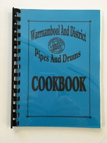
Booklet, Warrnambool & District Pipes & Drums Cookbook, Early 2000s
This cookbook was produced by the Warrnambool and District Pipes and Drums, partly as a fund-raiser and partly as a promotional exercise. A Pipe Band was formed in Warrnambool in 1906 with twelve foundation members. Simon Fraser was the original Pipe Major and the band has had some changes of name since its foundation. The band was not operating for some time during the years of World War One and again during World War Two but today under the name of Warrnambool and District Pipes and Drums it performs at concerts, dinners, band competitions, official functions, street parades etc and has won both Victorian and interstate Championship titles. This book is of interest as an example of a fund-raising exercise by a local organization early in the 21st century. This is a soft-cover book of 94 pages. It is a cookery book published by the Warrnambool and District Pipes and Drums. It has a blue cover overlaid with plastic and is bound with plastic rings. The front cover has the logo of the Warrnambool and District Pipes and Drums. It has an introduction, an acknowledgements page and two pages of information on the Warrnambool and District Pipes and Drums organization.Front Cover: ‘Warrnambool and District Pipes and Drums Cookbook’cookbook, warrnambool, warrnambool and district pipes and drums -
 Warrnambool and District Historical Society Inc.
Certificate - Motor Cycle Licence, Chief Commissioner of Police, Melbourne, 1916
This is a licence for a driver of a motor cycle in Victoria. The licence was issued in March 1916 to William Wines of Warrnambool. The licence was valid for one year. The form used was actually one for a motor car but the word 'cycle' was added in handwritten ink. This licence is of considerable interest as 1916 is an early date for the ownership of a motor cycle in WarrnamboolThis is a sheet of paper providing a motor cycle licence. The paper has the Victorian Coat of Arms, black printing and handwritten information in black ink. The paper is a little crumpled and stained. The paper has been torn and stuck together with adhesive tape on the back. early 20th century motor cycling, wines family warrnambool -
 Warrnambool and District Historical Society Inc.
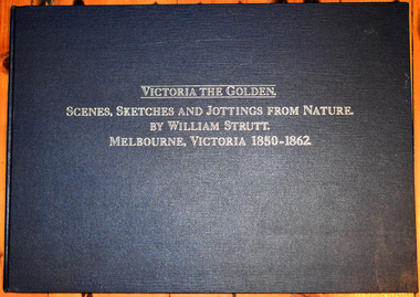
Book, William Strutt et al, Victoria The Golden - Scenes, Sketches and Jottings from Nature, 1980
... Victorian Colonial Art William Strutt Reproduction of an early ...Reproduction of an early Victorian artist's workThis is a book of 85 pages. It has a blue cover with gold lettering on the front cover and the spine. It contains printed text, reproductions of artistic works - sketches, lithographs and jottings. non-fictionReproduction of an early Victorian artist's workvictorian colonial art, william strutt -
 Warrnambool and District Historical Society Inc.
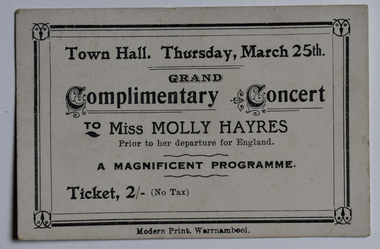
Card - Concert Ticket, Modern Print, Warrnambool, Complimentary Concert, 1926
This is a ticket for a complimentary concert to the Victorian soprano, Miss Mollie Hayres, in the Warrnambool Town Hall in 1926. Inez Mary (Mollie) Hayres (1897-1980) was born in Port Fairy and received her early musical training from the Good Samaritan Sisters in Port Fairy. She received local funding to enable her to study at the Melbourne Conservatorium of Music under Madame Weiderman and toured the Western District in 1926, supported by the pianist May Broderick and the violinist Cecil Parkes, in a series of complimentary concerts to give her funding to study in Europe. She became a well-known singer and singing teacher in Melbourne, featuring in radio programs and concerts. This ticket is of interest as a memento of Mollie Hayres, a noted singer in Victoria in the first half of the 20th century.This is a small white card with black edging and printing. Grand Complimentary Concert to Miss Mollie Hayresmollie hayres soprano, good samaritan sisters port fairy -
 Warrnambool and District Historical Society Inc.
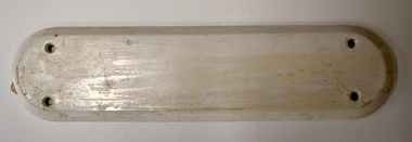
Archive - Door plate with Inscription, Leslie O'Callaghan, 1942
This door plate was found at 28 Spence Street, Warrnambool by the builder Ray Hollingsworth, when he was renovating the building for the Warrnambool Presbyterian Church in June 2019. He realized that the inscription had been placed there by Leslie O'Callaghan, probably when he left the premises in 1942 after boarding there for some years. Leslie O'Callaghan (1918-2014) was born in Balmoral and left there at the age of 13 with a scholarship to study at Warrnambool Technical School. He became an industrial chemist, working at the Kraft Walker Cheese Factory in Allansford (Warrnambool Cheese and Butter Factory). His experimental work in cheese cultures over a 45 year period was regarded as cutting edge work in the Victorian dairying industry. Known as 'Mr History', Leslie O'Callaghan was also an important Warrnambool historian, serving as president of the Warrnambool and District Historical Society for 35 years. In later life Les wrote about his time in 28 Spence Street, noting the lay-out of the early building and other boarders at the time. He never mentioned the interesting memento of his time there that he left on the back of a door plate. The Warrnambool and District Historical Society Archives Centre is called 'Les O'Callaghan History House'This door plate with its inscription was found 77 years after the inscription was written. It is of considerable interest because the writer of the inscription was well-known in Warrnambool as a bacteriologist and an historian. He left his own personal historical message and by sheer chance it was found years later. (All the old door plates at the time of the renovation were thrown out and it was fortunate that the builder happened to see the writing on one of them and to recognize who the writer was.)This is a cream-coloured ceramic door plate. It is rectangular-shaped with curved edges at the top and bottom. It has been painted white and has two holes at the top and bottom for the insertion of screws for a5taching the plate to the door. The inside of the plate has handwriting in black pencilLeslie Alexander O'Callaghan lived here for some years 1939-1942 AD. His occupation was as assistant bacteriologist for Kraft-Walker Cheese Coy. at Allansford. Born at Balmoral, 40 miles NORTH of Hamilton, Victorialeslie o'callaghan warrnambool, kraft walker cheese company allansford, 28 spence street warrnambool