Showing 1550 items matching "streetscapes"
-
 Bendigo Historical Society Inc.
Photograph - BRIDGE STREET: SANDHURST, 1861
Copy of black and white photo: Bridge Street streetscape near site of the present Chinese Museum. Showing Bendigo Hotel at left,. 'Crossingham & Goodman, Saddlers ' ' J. Holdsworth', 'Glass and Chines Warehouse'. 'Batchelder, Photographer, Pall Mall' handcart in foreground. 3 storey weatherboard building with 3 males at door, 2 males and photographers cart in front of fence. Row of single storey buildings with verandahs, some with business signs. 2 storey building at back. Deep gutters with foot bridges over. On back in grey lead '12' Note: Batchelder and his assistant are standing at the hardcart' ( James Lerk 22.9.2000 }Batchelder, Pall Mallplace, streetscape, bridge street -
 Ballarat Tramway Museum
Photograph - Black & White Photograph/s, The Courier Ballarat, 9/1971?
Yields information about the streetscape in Lydiard St wall where a feature, since demolished was a brick wall on the east side of the street, Three trams in the view, possibly of a charter.Black and White copy photograph of a newspaper photograph taken by The Courier - published 5/01/1976 No. 17 in Lydiard St North, near Macarthur St with two other bogie trams in the background. Date of photo unknown, but probably September 1971. Tram has the destination of Sebastopol and a Twin Lakes advertisement on the front panel. shows the brick wall cutting in Lydiard St North near Macarthur St and a general streetscape looking north. Collected by Alan Bradley from the Ballarat Courier early 1980's. See Excel file "Record of Ballarat Courier Photos SEC era" (Archive Documents) for source of details.On rear stamped "Copyright, The Ballarat Courier Proprietary Limited."tramways, trams, closure, lydiard st nth, tram 17 -
 Buninyong & District Historical Society
Photograph - Original B/W photograph, Mr Clive Brooks, Streetscape of Learmonth St., Buninyong, looking over roundabout to Town Hall and businesses, 18th September 1993
Part of a photographic record of Buninyong township. The buildings range from 1960s back to 1896, 1887, 1866, to a remnant of 1855, hidden within the shop of D. Brown electrician, consequently reflecting much alteration and change when compared to earlier photos.The streetscape is of historic significance, recording the detail of the streetscape in 1993. Many of the buildings have since undergone significant renovation/change.Streetscape of Learmonth St., Buninyong, looking over roundabout to Town Hall and businesses. Elm trees in the grounds of the Uniting (formerly Presbyterian) Church are seen in the background. Buildings are the fire station, council offices, Town Hall, Whykes Butchers, M. & D. Brown electrician, Buninyong Cake Shop and former bank, now a residence. Oak trees are in front of the council offices and shire hall. One tree planted in 1959 to mark the occasion of the connection of a water supply to Buninyong. A variety of elm is at the end of the row outside the Bank, now a residence. Junipers on each side of the former bank door was planted c1970.learmonth st, buninyong, bank, cake shop, m & d brown, electrician, whykes butchers, whykes, town hall, council offices, fire station -
 Bendigo Historical Society Inc.
Photograph - LONG GULLY HISTORY GROUP COLLECTION: STREETSCAPE
BHS CollectionBlack and white photo of a streetscape with various buildings, earth street and wood rail fencing. At the right edge is the Commercial Hotel. In the centre is a building with a veranda with P. Pentreath printed above the veranda. At the edge of the veranda is a sign with Post Office on it. Next is a Dr J W Sibley, Physician next to a bakery. On the left of the photo is a slab building with the windows propped open and a cart in the front of it. A two rail fence is in the front of the hut. There are other buildings in the background including what looks like a church behind the slab hut. The photocopy for this item is not available at this time, 23 Jan. 2020. The original photo for this item is at the bottom of box 621bendigo, history, long gully history group, the long gully history group - streetscape, p pentreath, commercial hotel, dr j w sibley? -
 Charlton Golden Grains Museum Inc
Photograph, Charlton Gentlemen's Club c. 1987, c.1987
The Charlton Gentleman's Club was established in 1900 by solicitor Ben Green. The original building had a narrow entrance off High St, between Egan & Spain's Grocery Shop and the Central Café. After fire damaged the buildings in the 1970s, the club was extended to its present size. The vacant block next door was formerly Clark's butcher's shop. Part of a series of streetscapes taken for the Charlton Shire in 1987. Charlton club was established in 1900 in a building with a narrow entrance off High Street between Egan and Spain's Grocery shop and the Central Cafe. After fire damaged the buildings in 1970's the Club was extended to its present size. The vacant block was formerly a butchers shop.Colour photograph of a single storey, glass fronted building with a white-framed front door. There is a large light pole and a white panel van and a white car are in front of the building. There is a blue awning over a yellow seat to the right of the building. Next to the seat is yellow metal fencing. On the far right of the photo is the side of an old brick building. charlton gentlemen's club, ben green, clark's butcher -
 Eltham District Historical Society Inc
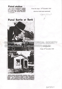
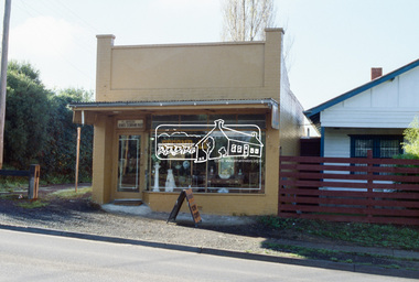
Document - Property Binder, 806 Main Road, Eltham
Photocopies newspaper articles re pistol stolen from National Bank, Greensborough by Kay Arthur Morgan: The Argus 10 December 1949, The Age 16 December 1949, The Age 17 December 1949, The Canberra Times 14 February 1950, The Argus 23 February 1950, The Argus 23 February 1950. Newspaper article: Community's colorful shop, Diamond Valley News, 8 December 1951, agency of Heidelberg branch of Commercial Bank of Australia, built by Mr Stebbins, line drawing from pre-1900 photograph of building and streetscape. Photocopy newspaper article: Long golden history, Diamond Valley Leader, 1 August 1997, built by George Stebbing, currently an opportunity shop.main road, eltham, businesses, pistol theft, commercial bank of australia, kay arthur morgan, george stebbing builder, senior constable n forbes, senior detective m mcennamin, h d pettie, detective sergeant k hubbard, inspector f hobley, senior detective r newton, detective p pedersen, senior detective l dent, senior detective j oakes, l a spear -
 Eltham District Historical Society Inc
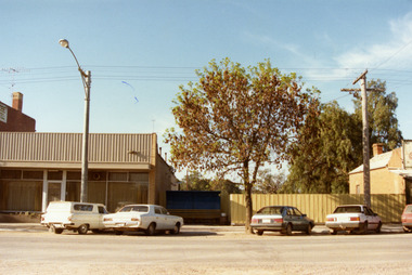
Slide - Photograph, Second Life, 736 Main Road, Eltham, c.May 1988
The c1920 brick shop and side dwelling is one of just three early 20th century shop buildings left in Eltham and one of just two that have intact facades. These shops are physical links with the country village of Eltham at that time and their siting in isolated locations along the street reflects that village era. Since the 1950s Eltham's main street has changed dramatically and the intact pre 1940 buildings such as this shop are key components of the section of Main Road south of Henry Street which still has a streetscape recognisable from that earlier time. The side dwelling illustrates the common practice of that time for shopkeepers to live at their premises. In the 1990s this was an antique Shop and in 2010 “Eltham Cycles”. It is now a popular eatery – Zen Den. 35mm colour positive transparency (1 of 23) Mount - Kodak EktachromeProcess Date MAY 88Meltham, main road, antiques and old wares, cafe zen den, restaurants, second hand dealer, second life decor pty ltd, shops -
 Eltham District Historical Society Inc
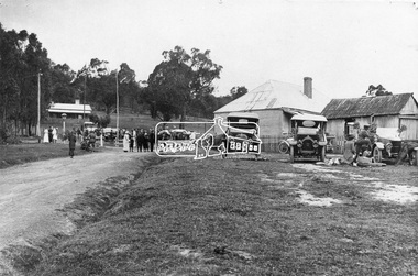
Photograph, Albert Jones, Returned soldiers picnic, Police Paddocks, Queenstown, c.1916
Queenstown (St Andrews) looking towards Panton Hill . A picnic is taking place. Streetscape with dirt road, buildings, Model T Fords and people. Police station far left, the gaol was behind (not visible). On the right is a boarding house according to Mr. Ninks, next to right the Mechanics Institute or library according to Miss Muller. On far right, Coach House (stables not shown) - end of coach run from Heidelberg. This is possibly a picnic for returned servicemen from Gallipoli. The house on the right still existed c.1970 and was alongside Hotel on Kinglake side. Reproduced page 35 Pioneers & Painters also on the back cover and on page 59 of "St Andrews: a village built on gold". Described in chapter headed "The Police Paddocks". This photo forms part of a collection of photographs gathered by the Shire of Eltham for their centenary project book,"Pioneers and Painters: 100 years of the Shire of Eltham" by Alan Marshall (1971). The collection of over 500 images is held in partnership between Eltham District Historical Society and Yarra Plenty Regional Library (Eltham Library) and is now formally known as the 'The Shire of Eltham Pioneers Photograph Collection.' It is significant in being the first community sourced collection representing the places and people of the Shire's first one hundred years.Digital image 4 x 5 inch B&W Neg Prints 20 x 25 and 9 x 12.5 cm sepp, shire of eltham pioneers photograph collection, queenstown, cars, police station, st andrews, model t ford, pioneers and painters, boarding house, gallipoli, picnic, police paddocks, retuned soldiers -
 Bendigo Historical Society Inc.
Photograph - PALL MALL, 1860 approx
Black and white photo. Streetscape, Pall Mall. Shop fronts from left to right include Macords Commercial Hotel, Thomas Rogers & Co., J. Barwick, H. Hoad & Co, Criterion Store, Batchelder Portrait Rooms, Parker & Macord, tobacconist shop, S. Alexander, Theatre Royal ( including Cobb & Co., booking office ) Original in State Library. On Front 'Batchelder/Sandhurst' Buggies and other vehicles at left and along road. Trees with guards planted along Pall Mall. Shows Pall Mall from corner of Bull St., ( Macords Commercial Hotel ) to Threatre Royal at Shamrock Hotel, near Williamson Street.Batchelderplace, streetscape, pall mall -
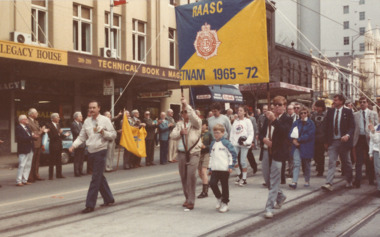
 Melbourne Legacy
Photograph, Vietnam Veterans March in 1988, 1988
It was at the first international reunion of Vietnam Veterans held in Melbourne, in October 1988. It included a march down Swanston St to the Shrine. There are more photos of Legatees outside Legacy House watching the veterans march past at 01579 and 01380. The 1988 parade of Vietnam Veterans in Melbourne was a significant event and Legacy provided rosemary sprigs for the event, a meal afterwards and Legatees attended. Other photos had a label which said 'The first international reunion of Vietnam Veterans was held in Melbourne in October 1988. Many of Melbourne Legacy's 'Legatees' stood to salute the marchers as they made their way to the Shrine of Remembrance.' Views of Swanston St streetscape in the background, including corner of Lonsdale and Swanston St looking south to the Shrine. Street banners said 'Remember' on a green and red background.The 1988 parade of Vietnam Veterans in Melbourne was a significant event and Legacy provided rosemary sprigs for the event, a meal afterwards and Legatees attended.Colour photo x 10 of a Vietnam Veterans march past Legacy House and a white paper label.White paper label handwritten in black 'Vietnam Veterans International Reunion. Melbourne Legatees salute Vietnam Vets.' Photos were taken by Susie Howard the publicity officer, and the date was 15.10.88.vietnam veterans, march, legatee event, streetscape -
 Glen Eira Historical Society
Photograph - Vermador
... Streetscapes ...Two black and white photocopies of a photograph of Vermador Private Hospital at 761 Glenhuntly Road, corner Watson Grove and Glenhuntly Road, taken c. 1920, Sr. Mary Stuart.glen huntly, vermador, hospitals, watson grove, stuart mary, streetscapes, glen huntly laundry, drapers, advertising signs, glenhuntly road, glenhuntly -
 Canterbury History Group
Photograph - 122 and 120 Maling Road, Canterbury in 1993, Jan Pigot, 1993
... Streetscapes ...Coloured photograph of Farren-Price and Antique Restoration shops on the south side of Maling Road. Both shops have been occupied since 1923 by varied businesses. No. 122 was the Commerical Bank from 1929-1942.canterbury, maling road, antique shops, gift shops, palm trees, hel> f and j, farren-price, canterbury mansions, banks, signs, streetscapes -
 Bendigo Historical Society Inc.
Photograph - KELLY MINE MODEL IN EASTER PROCESSION
Copies (2) of original photo: Print attached to back of photo : Mr. Fred Kelly ( in uniform ) with his complete working model of a mine which took part in the Easter Procession for many years. Mr. Kelly built the mine himself, and included a small steam engine to drive the stampers and make the cage go up and down. The mine was formerly on show upstairs in the Town Hall, and is now at the Deborah mine museum. Written on bottom of photo in black biro : Valda Pinder 54435593 Photo shows 6 seated men, one standing and one driving horse driven cart with mine model on cart. Two white horses drawing cart. Streetscape in background.bendigo, mining, kelly mine model -
 Melbourne Legacy
Photograph, Vietnam Veterans March in 1988, 1988
It was at the first international reunion of Vietnam Veterans held in Melbourne, in October 1988. It included a march down Swanston St to the Shrine. There are photos of Legatees outside Legacy House watching the veterans march past at 01578. The other photos include a meal provided at Legacy House after the parade at 01580. The 1988 parade of Vietnam Veterans in Melbourne was a significant event and Legacy provided rosemary sprigs for the event, a meal afterwards and Legatees attended. Other photos had a label which said 'The first international reunion of Vietnam Veterans was held in Melbourne in October 1988. Many of Melbourne Legacy's 'Legatees' stood to salute the marchers as they made their way to the Shrine of Remembrance.' Views of Swanston St streetscape in the background, including the old CUB brewery building at the top of Swanston St. Street banners said 'Remember' on a green and red background.The 1988 parade of Vietnam Veterans in Melbourne was a significant event and Legacy provided rosemary sprigs for the event, a meal afterwards and Legatees attended.Colour photo x 10 of a Vietnam Veterans march past Legacy House and a white paper label.White paper label handwritten in black 'Vietnam Veterans International Reunion. Melbourne Legatees salute Vietnam Vets.' Photos were taken by Susie Howard the publicity officer, and the date was 15.10.88.vietnam veterans, march, legatee event, streetscape -
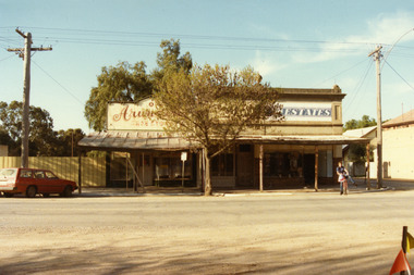 Charlton Golden Grains Museum Inc
Photograph, Arundell's Shoe Shop, High St Charlton c. 1987, c.1987
Arundell's Shoe Shop and Dalgety's Agency , centre of High St Charlton, north side c. 1987. Corner of High St and Williams Ave (now John Curtin Drive). Right hand building built by William Williams as a saddlery c. 1910. Arundell's Shoe Shop formerly ANA Boot and Shoe Shop established by John Arundell in 1901. The shop was sold by Vic Arundell in 1980 and closed. Next door was John Watson's Stock & Station Agents which later became Dalgety's. The end shop was the saddlery and then Bullock's grocery 1930's to 1970's. In 1957 became Charlton's first self service store. Became Australian Estates late 1970s. The shops were later demolished to make way for the Traveller's Rest. Part of a streetscape series taken in 1987 for the Charlton Shire.Colour photograph of three single-storey shops with corrugated tin verandahs. Signage on the buildings reads Arundell's SHOE STORE and ESTATES. Partially obscured by tree in front of the buildings. A red station wagon is parked on the LH side of the picture and a boy on a bicycle on the RH side. arundell, dalgety's, williams saddery, john watson stock & station agent, bullock's grocery, australian estates, arundell's shoe store, business, industry, charlton -
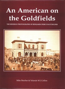 Bendigo Historical Society Inc.
Book - AN AMERICAN ON THE GOLDFIELDS, THE BENDIGO PHOTOGRAPHS OF BENJAMIN PIERCE BATCHELDER, 2001
... streetscapes ...AN AMERICAN ON THE GOLDFIELDS, THE BENDIGO PHOTOGRAPHS OF BENJAMIN PIERCE BATCHELDER. 134 pages with photos and illustrations.Mike Butcher and Yolande M.J. Collinsbendigo, history, benjamin batchelder, bendigo, mining, goldfields, benjamin batchelder, streetscapes, industry, architecture, heritage buildings, history -
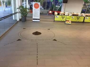 Greensborough Historical Society
Photograph - Digital Image, Art at WaterMarc, July 2017, 22/07/2017
Photographs of an art installation by Jessie Stanley at WaterMarc Greensborough on 22/07/2017. From Jessie Stanley's FaceBook page :Dust to Dust is complete... It's an ephemeral site-specific work about how the Melbourne suburb of Greensborough has transformed over time. This area's exceptionally fertile soil [used by] by white settlers for farms, market gardens and orchards reshaped the Wurundjeri's traditional lands - and today the private sale and division of these farms informs the streetscape and town plan. With soil sourced locally this work reveals some of the area’s history - the text running around the perimeter was written by former resident Val Wilson, a snippet of her recollections of growing up in the area in the 1950s. The arrows and text act like a compass to orientate this site with greater Melbourne. On display in the lobby of Banyule Council until chance, time (or a broom) sweeps it away, Many thanks to Banyule City Council, Greensborough Historical Society and Valerie Wilson. "An artistic representation of Greensborough's history.Digital photographs of art installation.jessie stanley, watermarc, greensborough historical society, banyule council -
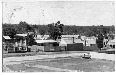 Tarnagulla History Archive
Photograph of Tarnagulla from Poverty Street, behind Bank, Tarnagulla from Poverty Street, behind Bank, Between 1886 and 1899
... streetscapes ...Murray Comrie Collection. Information collated by Murray Comrie: Photo after 1886 and before 1899. Shows bakers shop at corner of Commercial Rd and Poverty St, bakery stables and horse. Clouston's, Renshaw's Victoria House, Golden Age Hotel, Renshaw's Commerce House and Post Office. This is an original photographic postcard. Monochrome photographic postcard. View of part of Commercial Road and Poverty Streets, Tarnagulla, from a position on Poverty Street behind the Bank site. Premises on Commercial Road which are visible include the Golden Age Hotel and Renshaw's Drapers.Text near bottom edge: 'Johnsn & Co. Ararat' and 'Tarnagulla'.tarnagulla, commerce, shops, businesses, streetscapes, horses, stables, poverty street, commercial road, main street, golden age hotel, renshaw's, bakery, clouston's -
Canterbury History Group
Photograph - Maling Road shops and environs, Stuart Warmington, 1993
Photographs recording interiors and exteriors of Canterbury shops, shopkeepers and Federation details of architecture. Section A -Maling Road shops, south side - 87 coloured photographs taken by Jan Pigot in 1993.|Section B- Maling Road shops, north side - 88 coloured photographs taken by Jan Pigot in 1993.|Section C- Bryson Street shops - car park - 4 coloured photographs taken by Jan Pigot in 1993-4.|Section D- Canterbury shops and streetscapes - 76 coloured photographs taken by Stuart Warmington c.1995.|Section E- Maling Road shops, north side - 27 coloured photographs taken by Stuart Warmington c. 1995.|Section F- Maling Road shops, north and south side - 24 coloured photographs taken by Stuart Warmington 1995.|Section G- Plaques and Signs in Canterbury - 14 coloured photographs taken by Jan Pigot c. 1994.maling road, canterbury, shops, shopkeepers, hel> f, petroro> tony, bourke> francis, d'annibale> grace, buckley> june, buckley> ken, godfrey, greengrocers, newsagents, gift shops, furniture restorers, florists, nurseries (plants), cake shops, cafes, butchers -
 The Beechworth Burke Museum
Photograph, 1983
These five images, photographed in 1983, depict locations in Ireland that Ned Kelly's father, John "Red" Kelly may have frequented. John Kelly was born on the 20th of February 1820 and worked as a laborer in Ireland. His parents were named Thomas Kelly and Mary Cody. He had a fresh complexion, large head and reddish coloured hair. John Kelly was sentenced in Tipperary, Ireland for the theft of a pig and received 7 years in Van Diemen's Land (now known as Tasmania). He sailed on the ship "Prince Regent" and arrived in VDL on the 2nd of January 1842 with 11 other convicts. John Kelly completed his sentence and moved to Beveridge in Victoria where he met and married Ellen Quin. The couple had 7 children, one of these is Ned Kelly the Bushranger. He died at the young age 46 in 1866. County Tipperary is a county located in Ireland in the province of Munster. It was established in the early thirteenth century, shortly after the Norman invasion of Ireland. These photographs, taken by an unidentified photographer, show the streetscape of Tipperary, the remains of a coachyard and stables, a saddlery yard and a fashion shop. These images are part of the Burke Museum's Kelly album which are of great use to researchers in the reconstruction of the Kelly story. Images like these, which portray an area which John Kelly resided in his youth, have research potential in reconstructing the conditions and quality of life for the Kelly parent. However, these images are not only important for their connection to the Kelly story but also for what they can provide and reveal for Ireland in the 1980s.A collection of five colour rectangular photographs printed on matte photographic paper10269.1 Reverse: TOWNSEND ST. BANBRIDGE / CO. DOWN N. IRELAND 10269.1 Reverse: TOWNSEND ST. BANBRIDGE / CO. DOWN N. IRELAND 10269.3 Reverse: REMAINS OF COCHYARD AND STABLES / BANBRIDGE CO. DOWN / FREQUENTED BY NED KELLY'S / FATHER 10269.4 Reverse: STABLES AND SADDLERY YARD / THROUGH ENTRANCE FROM / SHOP. PHOTOGRAPH 3 / 10269.5 Reverse: ENTRANCE TO STABLES AND / SADDLERY. FASHION'S SHOP TO LEFT / OF ENTRANCE WAS THE ORIGINAL / SADDLERY SHOP. / BANBRIDGE CO. DOWN / 3kelly album, kelly family, ned kelly, northern ireland, irish heritage, tourism, john kelly, john 'red' kelly -
 Bendigo Historical Society Inc.
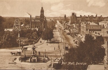
Photograph - PALL MALL, BENDIGO, c1903-1918
Two identical post cards: 'Pall Mall', Bendigo streetscape, fountain in foreground, horse-drawn cab, cable trams, Hustler's Royal Reserve Mine, Post Office, Henderson & Goodisson Beehive sign clearly visible. Physical description: loose photograph, sepia. Inscriptions markings: on back of photo - The 'Valentine & Sons' Publishing Co., Ltd., Melbourne. POST CARD. Printed in Great Britain. This space to be used for communication. The Address only to be written here. On front - Pall Mall, Bendigo. Also 300.336 then the letters JK in a circle. On back of the second postcard: Royal Historical Society of Victoria, Bendigo Branch. Hustlers Royal Reserve No.2 data. Hustlers Royal, Pall Mall, Bendigo. RSL Memorial Hall now occupies site. Depth of Shaft - 1,660 feet. Formed 1885; Closed 1917. Poppet Legs - Steel, 60 feet high. Winding engine: First motion, 24 in. Cylinders, 10ft. Drums. Gold yields - 10,262 oz. Dividends 3,200 pounds.The Valentine & Sons' Publishing Co., Ltd., Melbournebendigo, pall mall, rhsv, hustlers royal reserve -
 Bendigo Historical Society Inc.
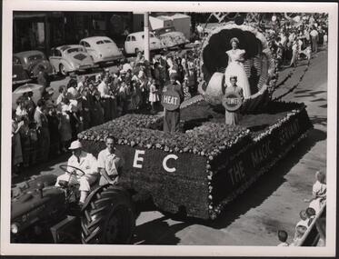
Photograph - HANRO COLLECTION: A COLLECTION OF STREET EASTER PARADE PHOTOGRAPHS
BHS CollectionA Collection of Street Parade Photographs: Three photos all black and white. The first is of the S.E.C. float with *The Magic Servant* being pulled by a tractor with two men aboard. The float is of grass and flowers. Three children are on the float holding signs of Heat, Power, ?. A girl stands in a decorative shell. The street scene is lined with many people and cars of the day are parked at the road edge. The second is of the White Christmas Golden Square Mothers Club. A truck is decorated with a large Christmas tree with children dressed for winter. At the right is a sign*Bendigo Olympic Pool Fun is now open* on the balcony with a crowd of people. The streets are lined with spectators with flags flying above the parade. The Third is a float carrying a train with VR in flowers on the side and a floral display on the float. A crown of flowers at the front and the train on rails is featured. The train is No: B60 and is named the *Harold W. Clapp* All photos are of Bendigo's streetscape. All three photo's have two holes 7.4cm apart for housing in a folder. Box 116Aphotograph, streetscape, bendigo, bendigo. parade. golden square mothers club. -
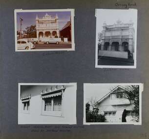 Glen Eira Historical Society
Album - Album page, Orrong Road, Circa 1972
... streetscapes ...This photograph is part of the Caulfield Historical Album 1972. This album was created in approximately 1972 as part of a project by the Caulfield Historical Society to assist in identifying buildings worthy of preservation. The album is related to a Survey the Caulfield Historical Society developed in collaboration with the National Trust of Australia (Victoria) and Caulfield City Council to identify historic buildings within the City of Caulfield that warranted the protection of a National Trust Classification. Principal photographer thought to be Trevor Hart, member of Caulfield Historical Society. Most photographs were taken between 1966-1972 with a small number of photographs being older and from unknown sources. All photographs are black and white except where stated, with 386 photographs over 198 pages.Victorian Heritage Database https://vhd.heritagecouncil.vic.gov.au/places/35576 No. 70 Orrong Road is important as an exceptionally ornate Boom style villa residence in the terraced form and in this respect is rare in Caulfield. Its architectural value is enhanced by its intact state and by the manner in which its bold architectural expression is carried through into the hallway and staircase. Victorian Heritage Database - National Trust local significance 284 Orrong Road Caulfield https://vhd.heritagecouncil.vic.gov.au/places/65700 A house designed by Harold Desbrowe Annear in 1917 and believed to have been the first "all electric" house in Melbourne. It has been extensively altered.Page 164 - four photographs of 2 different houses on Orrong Road. The top left photo is in colour while the others are in black and white.Handwritten: Orrong Road [top right] / Lisborn House [ (ed. correct name is LISBON HOUSE), under top left photo] / Lisborn House [under top right photo] / [under bottom right photo] / CORNER ORRONG ROAD AND PEARSON AVENUE / HOUSE BY DESBROWE ANNEAR [under bottom left photo] / 164 [bottom right]trevor hart, orrong road, lisbon house, lisborn house, elsternwick, pearson grove, st kilda east, caulfield north, terrace houses, cast iron work, verandahs, balconies, parapets, arches, cars, streetscapes, attic houses, desbrowe annear -
 Eltham District Historical Society Inc
Photograph, Doug Orford, Eltham Courthouse, 730 Main Road, Eltham, 1985, 1985
This building is a fine example of a very early small brick country court house which retains its furnishings and has important associations with the early history of the Eltham township. It was used for Eltham Road Board meetings in the 1860s and later to provide additional school accommodation. It is the oldest public building remaining in Eltham and forms an important group in historic and streetscape terms with the adjoining former police residence. The survival of the furnishings (of unknown origins) is of particular significance given the building's age. This building, and the former police residence beside it, were constructed as a result of a petition by five Eltham residents in 1857. The nearest police were at Heidelberg eight miles away or at the Caledonia Diggings 21 miles away. After the construction of the Court of Petty Sessions at Eltham in 1859-60 (which was designed by the Public Works Department and built by a Mr Duncan for a cost of 536 pounds), it was used for a variety of purposes. Eltham Road Board meetings were held there until 1868 when the board was transferred to Kangaroo Ground and as the Road Board Secretary's office, until this was transferred to Wingrove Cottage in 1867. It was used as an overflow for the Dalton Street School in 1875. According to National Trust records, the Eltham Court House is a relatively rare building type. There are only six other known examples of similar small brick country court houses in the state which have small projecting entry porches and a gabled form. Roll of 35mm colour negative film, 7 stripsFuji 100Neltham, eltham courthouse, main road -
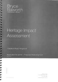 Ringwood and District Historical Society
Book, Bryce Raworth, Heritage Impact Assessment - 1 Bedford Road, Ringwood, Victoria. Application for permit - Proposed Redevelopment - July 2021, 2021
A4 size wire-bound book compiled by Bryce RaworthINTRODUCTION: This heritage impact assessment (HIS) was prepared at the request of the City of Maroondah, the owner of the subject property at 1 Bedford Street (sic), Ringwood. It relates to a proposal to demolish the existing shop on the site and construct a multi-storey car park incorporating a commercial tenancy at the lower levels. It reviews the significance of the existing building on the site and the contribution it makes to the surrounding streetscapes, then comments on the heritage impacts of the proposed demolition in the context of the significance of the place and broader considerations. This office has previously provided an Historical Overview of the subject site (June 2020) and this assessment draws upon that previous research and analysis. The report has been prepared by Guy Murphy and Bryce Raworth. CONCLUSION: The proposed demolition of the former Blood Brothers Store at 1 Bedford Street (sic), Ringwood and the construction of a multi-storey car park on the enlarged site will result in the loss of some significance to the Heritage Overlay. The degree of loss is moderated by the partial intactness of the store, its modest character and the loss of its original setting, as well the proposal to implement a heritage interpretation strategy for the site. When considered in the context of the broader range of urban planning considerations and broader net community benefit, the proposed development is supported with respect to heritage impacts. -
 The Beechworth Burke Museum
Photograph - Carte de Visite, William E Barnes
In July of 1880, Ann Jones' successful hotel in Glenrowan burnt to the ground during the Kelly siege. She had opened her business in the year prior having been unsuccessful in her attempt to run a tea-room business in Wangaratta. The first building on this particular site was the home Ann Jones had built for herself and her family. Two years later she converted the home and added the hotel to the rear of the structure. One year later it was burnt to the ground. This image depicts the streetscape of Glenrowan in 1883, three years after the siege. Importantly, it reveals the appearance of several buildings which can reveal information for how Glenrowan (as a small town) might have stood during the siege. These buildings are of typical Australian colonial "miner's cottage" style. On what would have been the site of Ann Jones' hotel, to the far left of the photograph, a police station stands. This police station was built before April 1883. This Carte-de-viste (CdV) taken by renowned Wangaratta based photographer William Edward Barnes previously belonged to the donor's grandfather, Daniel Mullins who was a Police Officer stationed at Glenrowan soon after the Kelly gang siege. Today, the siege has become an important part of Australian culture and Ned Kelly and the Kelly Gang (comprising of Ned Kelly, Dan Kelly, Steve Hart and Joe Byrne) has become ingrained in Australian history and mythology. A CdV is a sepia toned photograph mounted on card and is generally of a small size. This particular style was first patented by Andre Adolphe Eugene Disdéri (1819-1889) in 1854. In 1857, the CdV was introduced to England and after photographs of Queen Victoria, Prince Albert and their family were taken using CdV in 1860 the popularity of this method reached a peak.This photograph is part of the Burke Museum "Kelly album" which includes a significant collection of photographs and artefacts connected to Ned Kelly and the Kelly Gang. Ned Kelly and his gang have become ingrained in Australian popular culture and thus many museums, art galleries and private collections house material connected to the Kelly story which allows the events and people to be researched and interpreted. Artefacts and photographs pertaining to the Kelly gang are particularly valuable for Australian museums. This particular photograph is significant for its connection to Wangaratta based photographer William Edward Barnes and to the Glenrowan Siege and Ann Jones' Hotel which burnt down during the siege in June 1880. Taken in 1883, this photograph has the opportunity to provide information about the townscape of Glenrowan shortly after the siege. It also provides important insight into the architecture and layout of the town. To the far right of the image, the photograph depicts the police station which was built on the site of Ann Jones' Hotel which can provide important information for the Kelly story and how the town evolved following 1880. It is also interesting to emphasise that the police station was built on the site of Ned Kelly and the Kelly gang's last stand.This photograph is a sepia image mounted on yellow card which depicts the newly built police station (in 1882) which stands on the far right of the image on the site of the former Ann Jones Hotel. A fence appears through the lower front of the image and an open paddock is to the left. In the rear centre of the image, there is a mountain. In front of the mountain are many trees, most of them gum. The police station is a one storey structure with a veranda and there are three doorways visible in the image. The image depicts four windows on the front of the station.W.E.Barnes / photographer / Wangaratta / ...1882 / BMM8087kelly album, william barnes, wangaratta photographer, carte-de-viste, glenrowan, 1882, police station, ann jones inn, ann jones hotel, kelly siege, glenrowan siege, colonial australia -
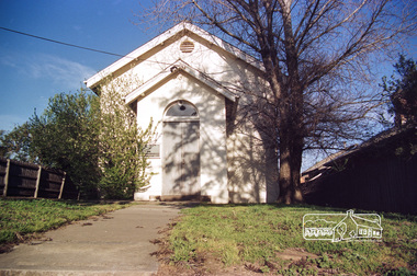
 Eltham District Historical Society Inc
Photograph - Digital Photograph, Alan King, St Matthew's Church and Hall, Panton Hill, 27 March 2008
St. Matthew's Church has historic significance as the town's church and physical and social focus for the community. The standard design buildings are good examples and important streetscape elements. The war memorial cross is the area's monument to the 20th century wars and its modest scale in comparison with the granite Eltham and towered Kangaroo Ground memorials illustrates the lack of affluence in the town and surrounding area. The grouping of church, school, store and post office is typical of country villages throughout Victoria. The Radiata Pine plantings are significant as an intact line of shelterbelt planting typical of the early 20th century. (Bick Study 1992) Covered under Heritage Overlay, Nillumbik Planning Scheme. Published: Nillumbik Now and Then / Marguerite Marshall 2008; photographs Alan King with Marguerite Marshall.; p63 Panton Hill’s first church services were held in a simple building made of paling timber, opposite the Hotel de France. The building was also used for Sunday School, a school and a hall.1 The St Matthew’s Church and hall at the corner of Church Road and Kangaroo Ground-St Andrews Road, were built in the early 20th century in the standard rectangular style of the times. The intact belt of Radiata Pines was common at that time. The war memorial concrete cross is the area’s monument for the 20th century wars. It is much more modest than those in Eltham, and particularly in Kangaroo Ground, demonstrating those townships’ comparative affluence.2 Early settler J Hughes, who donated the land to the Church of England, was the first to be married at St Matthews when he married Rachel Coutie. In later life he became a minister of religion.3 One much-liked preacher was George Hollow, who with his sister playing the harmonium, conducted church services at Panton Hill, St Andrews and Christmas Hills, for many years.This collection of almost 130 photos about places and people within the Shire of Nillumbik, an urban and rural municipality in Melbourne's north, contributes to an understanding of the history of the Shire. Published in 2008 immediately prior to the Black Saturday bushfires of February 7, 2009, it documents sites that were impacted, and in some cases destroyed by the fires. It includes photographs taken especially for the publication, creating a unique time capsule representing the Shire in the early 21st century. It remains the most recent comprehenesive publication devoted to the Shire's history connecting local residents to the past. nillumbik now and then (marshall-king) collection, panton hill, st matthew's church, panton hill war memorial -
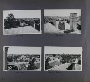 Glen Eira Historical Society
Album - Album page, Myoora, 405 Alma Road, Circa 1972
... streetscapes ...This photograph is part of the Caulfield Historical Album 1972. This album was created in approximately 1972 as part of a project by the Caulfield Historical Society to assist in identifying buildings worthy of preservation. The album is related to a Survey the Caulfield Historical Society developed in collaboration with the National Trust of Australia (Victoria) and Caulfield City Council to identify historic buildings within the City of Caulfield that warranted the protection of a National Trust Classification. Principal photographer thought to be Trevor Hart, member of Caulfield Historical Society. Most photographs were taken between 1966-1972 with a small number of photographs being older and from unknown sources. All photographs are black and white except where stated, with 386 photographs over 198 pages.Victorian Heritage Register (VHR) Number H0490 From the Victorian Heritage Register Database - Citation for Myoora https://vhd.heritagecouncil.vic.gov.au/places/275 (as at 6/10/2020) Myoora, 405 Alma Road, North Caulfield, was designed by Reed, Henderson & Smart and can be attributed to Anketell Henderson. It was built in 1886 and 1887 for Thomas Christian, who had founded the fabled gold mine, the Day Dawn at Charters Towers. He never occupied the house although his widow lived there for some time. The house was subdivided into three and later six flats. Myoora was one of many large mansions on broad acres with gardens in Caulfield. Perhaps the grandest was Labassa. The mansions date from the 1850s through to the late 1890s. The siting of Myoora on a ridge influenced its planning and composition. A central hall and corridor along the ridge is entered from the centre of the more formal north facade. The entrance is marked by an elaborately detailed tower. A stair turret provides a second accent. The western end of the building is completed by a massively detailed chimney as the service wing. The south facade enjoyed an outlook to port phillip from a two-storey cast iron verandah. Bay windows, chimneys, the tower and the turret and minor details are brought together in a sophisticated asymmetrical composition. This is reflected in the planning. The asymmetry of Myoora pivoting on the tower is the most notable feature of the building. The walls are built of cement rendered brick. The cement render has not been painted. The roof is slate. The balconies and verandah are cast iron. The footings and cellar are bluestone. The architectural firm Reed, Henderson & Smart was very prominent in Victoria in the nineteenth century. Anketell Henderson was an eminent and well respected member of the profession. He worked successfully in London and interstate as well as in Victoria. They were better known for commercial and public buildings. Myoora is an important private commission. The style of Myoora is a combination of details from the Continental and English Renaissance through the boom style and the Queen Anne style. There is also an early influence from the American Romanesque style especially in the stair turret. The latter style was important at the turn of the century and Myoora is a significant precursor. Other buildings of a similar scale survive in Caulfield and elsewhere. Labassa, the most fabulous, is quite different stylistically as are most of the other comparable mansions. Stonnington is perhaps closer but relies on different details from the Queen Anne style and lacks any American influence. For its historical associations through its owners and architects, for its style and composition and for its intactness, Myoora is significant at a State level. The craftmanship of Myoora is what could be expected of a building of the time and type. It is relatively intact and in fair condition. The main staircase has been removed, minor alterations to decorative features have occurred and additions have been made to the exterior.Page 17 of Photograph Album including four black and white photographs. All are arranged in landscape orientation with two on the top half of the page and the other two below.Handwritten: Neg 185 Dec 1972 [under top left photo] / Dec 1972 [under top right photo] / Dec 1972 [under bottom left photo] / Neg 153 Dec 1972 [under bottom right photo] / 17 [bottom left]caulfield north, trevor hart, alma road, mansion, myoora, tower, thomas christian, 1880's, queen anne, cement rendered brick, unpainted, balconies, verandahs, anketell henderson, continental and english renaissance, american romanesque, cast iron balconies, panoramic views, streetscapes, cast iron work, reed henderson & smart, gardens, asymmetrical style, slate roofs -
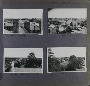
 Glen Eira Historical Society
Album - Album page, Myoora, 405 Alma Road, Circa 1972
... streetscapes ...This photograph is part of the Caulfield Historical Album 1972. This album was created in approximately 1972 as part of a project by the Caulfield Historical Society to assist in identifying buildings worthy of preservation. The album is related to a Survey the Caulfield Historical Society developed in collaboration with the National Trust of Australia (Victoria) and Caulfield City Council to identify historic buildings within the City of Caulfield that warranted the protection of a National Trust Classification. Principal photographer thought to be Trevor Hart, member of Caulfield Historical Society. Most photographs were taken between 1966-1972 with a small number of photographs being older and from unknown sources. All photographs are black and white except where stated, with 386 photographs over 198 pages.Victorian Heritage Register (VHR) Number H0490 From the Victorian Heritage Register Database - Citation for Myoora https://vhd.heritagecouncil.vic.gov.au/places/275 (as at 6/10/2020) Myoora, 405 Alma Road, North Caulfield, was designed by Reed, Henderson & Smart and can be attributed to Anketell Henderson. It was built in 1886 and 1887 for Thomas Christian, who had founded the fabled gold mine, the Day Dawn at Charters Towers. He never occupied the house although his widow lived there for some time. The house was subdivided into three and later six flats. Myoora was one of many large mansions on broad acres with gardens in Caulfield. Perhaps the grandest was Labassa. The mansions date from the 1850s through to the late 1890s. The siting of Myoora on a ridge influenced its planning and composition. A central hall and corridor along the ridge is entered from the centre of the more formal north facade. The entrance is marked by an elaborately detailed tower. A stair turret provides a second accent. The western end of the building is completed by a massively detailed chimney as the service wing. The south facade enjoyed an outlook to Port Phillip from a two-storey cast iron verandah. Bay windows, chimneys, the tower and the turret and minor details are brought together in a sophisticated asymmetrical composition. This is reflected in the planning. The asymmetry of Myoora pivoting on the tower is the most notable feature of the building. The walls are built of cement rendered brick. The cement render has not been painted. The roof is slate. The balconies and verandah are cast iron. The footings and cellar are bluestone. The architectural firm Reed, Henderson & Smart was very prominent in Victoria in the nineteenth century. Anketell Henderson was an eminent and well respected member of the profession. He worked successfully in London and interstate as well as in Victoria. They were better known for commercial and public buildings. Myoora is an important private commission. The style of Myoora is a combination of details from the Continental and English Renaissance through the boom style and the Queen Anne style. There is also an early influence from the American Romanesque style especially in the stair turret. The latter style was important at the turn of the century and Myoora is a significant precursor. Other buildings of a similar scale survive in Caulfield and elsewhere. Labassa, the most fabulous, is quite different stylistically as are most of the other comparable mansions. Stonnington is perhaps closer but relies on different details from the Queen Anne style and lacks any American influence. For its historical associations through its owners and architects, for its style and composition and for its intactness, Myoora is significant at a State level. The craftmanship of Myoora is what could be expected of a building of the time and type. It is relatively intact and in fair condition. The main staircase has been removed, minor alterations to decorative features have occurred and additions have been made to the exterior.Page 16 of Photograph Album including three black and white photographs. Two are arranged in landscape orientation on the right hand side of the page with the other photo in portrait mode on the left hand side. Handwritten: views from "Myoora" 405 Alma Road [top right] / Neg 181 Dec 1972 [under left side photo] / Neg 189 Dec 1972 [under bottom right photo] / 16 [bottom right]caulfield north, trevor hart, alma road, mansion, myoora, tower, thomas christian, 1880's, queen anne, cement rendered brick, unpainted, balconies, verandahs, anketell henderson, continental and english renaissance, american romanesque, cast iron balconies, panoramic views, streetscapes, cast iron work, reed henderson & smart, gardens, asymmetrical style, slate roofs, chimneys -
 Glen Eira Historical Society
Album - Album page, Myoora, 405 Alma Road, Circa 1972
... streetscapes ...This photograph is part of the Caulfield Historical Album 1972. This album was created in approximately 1972 as part of a project by the Caulfield Historical Society to assist in identifying buildings worthy of preservation. The album is related to a Survey the Caulfield Historical Society developed in collaboration with the National Trust of Australia (Victoria) and Caulfield City Council to identify historic buildings within the City of Caulfield that warranted the protection of a National Trust Classification. Principal photographer thought to be Trevor Hart, member of Caulfield Historical Society. Most photographs were taken between 1966-1972 with a small number of photographs being older and from unknown sources. All photographs are black and white except where stated, with 386 photographs over 198 pages.Victorian Heritage Register (VHR) Number H0490 From the Victorian Heritage Register Database - Citation for Myoora https://vhd.heritagecouncil.vic.gov.au/places/275 (as at 6/10/2020) Myoora, 405 Alma Road, North Caulfield, was designed by Reed, Henderson & Smart and can be attributed to Anketell Henderson. It was built in 1886 and 1887 for Thomas Christian, who had founded the fabled gold mine, the Day Dawn at Charters Towers. He never occupied the house although his widow lived there for some time. The house was subdivided into three and later six flats. Myoora was one of many large mansions on broad acres with gardens in Caulfield. Perhaps the grandest was Labassa. The mansions date from the 1850s through to the late 1890s. The siting of Myoora on a ridge influenced its planning and composition. A central hall and corridor along the ridge is entered from the centre of the more formal north facade. The entrance is marked by an elaborately detailed tower. A stair turret provides a second accent. The western end of the building is completed by a massively detailed chimney as the service wing. The south facade enjoyed an outlook to port phillip from a two-storey cast iron verandah. Bay windows, chimneys, the tower and the turret and minor details are brought together in a sophisticated asymmetrical composition. This is reflected in the planning. The asymmetry of Myoora pivoting on the tower is the most notable feature of the building. The walls are built of cement rendered brick. The cement render has not been painted. The roof is slate. The balconies and verandah are cast iron. The footings and cellar are bluestone. The architectural firm Reed, Henderson & Smart was very prominent in Victoria in the nineteenth century. Anketell Henderson was an eminent and well respected member of the profession. He worked successfully in London and interstate as well as in Victoria. They were better known for commercial and public buildings. Myoora is an important private commission. The style of Myoora is a combination of details from the Continental and English Renaissance through the boom style and the Queen Anne style. There is also an early influence from the American Romanesque style especially in the stair turret. The latter style was important at the turn of the century and Myoora is a significant precursor. Other buildings of a similar scale survive in Caulfield and elsewhere. Labassa, the most fabulous, is quite different stylistically as are most of the other comparable mansions. Stonnington is perhaps closer but relies on different details from the Queen Anne style and lacks any American influence. For its historical associations through its owners and architects, for its style and composition and for its intactness, Myoora is significant at a State level. The craftmanship of Myoora is what could be expected of a building of the time and type. It is relatively intact and in fair condition. The main staircase has been removed, minor alterations to decorative features have occurred and additions have been made to the exterior.Page 18 of Photograph Album including four black and white photographs. All are arranged in landscape orientation with two on the top half of the page and the other two below.Handwritten: views from "Myoora" 405 Alma Road / [top right hand] / Neg 188 Dec 1972 [under top left photo] / Dec 1972 [under top right photo] / Neg 184 Dec 1972 [under bottom left photo] / Neg 168 Dec 1972 [under bottom right photo] / 18 [bottom right]caulfield north, trevor hart, alma road, mansion, myoora, tower, thomas christian, 1880's, queen anne, turret, cement rendered brick, unpainted, balconies, verandahs, anketell henderson, continental and english renaissance, american romanesque, cast iron balconies, panoramic views, streetscapes, cast iron work, reed henderson & smart, asymmetrical style, gardens, slate roofs