Showing 7090 items matching "snowy-river"
-
 Greensborough Historical Society
Photograph - Digital image, Marilyn Smith et al, Janefield Precinct: gumtree, 27/11/2014
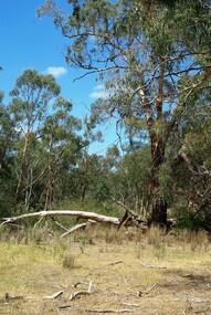
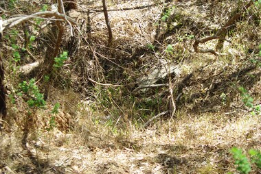
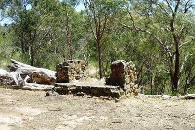
Janefield Precinct: gum tree. The remains of this site are between Greensborough and Janefield. A RAAF Hygiene Training Camp was located on the Plenty River, just south of the Janefield community. It was in use from 1944 to 1946. The Camp was constructed from salvaged materials. Instruction included building and maintenance of grease traps, latrines, elementary plumbing and carpentry.Early remains of a WW2 training campDigital colour photograph.janefield -
 Greensborough Historical Society
Photograph - Digital image, Marilyn Smith et al, Janefield Precinct: hawthorn trees, 27/11/2014
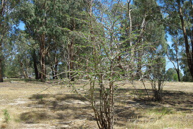
Janefield Precinct: hawthorn trees. The remains of this site are between Greensborough and Janefield. A RAAF Hygiene Training Camp was located on the Plenty River, just south of the Janefield community. It was in use from 1944 to 1946. The Camp was constructed from salvaged materials. Instruction included building and maintenance of grease traps, latrines, elementary plumbing and carpentry.Early remains of a WW2 training campDigital colour photograph.janefield, raaf hygiene training camp janefield -
 Greensborough Historical Society
Photograph - Digital image, Marilyn Smith et al, Janefield Precinct: more pondering - Janefield view, 27/11/2014
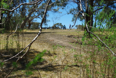
More pondering - Janefield view. The remains of this site are between Greensborough and Janefield. A RAAF Hygiene Training Camp was located on the Plenty River, just south of the Janefield community. It was in use from 1944 to 1946. The Camp was constructed from salvaged materials. Instruction included building and maintenance of grease traps, latrines, elementary plumbing and carpentry.Early remains of a WW2 training camp Digital colour photograph. -
 Greensborough Historical Society
Photograph - Digital image, Marilyn Smith et al, Janefield Precinct: Lone kangaroo, 27/11/2014
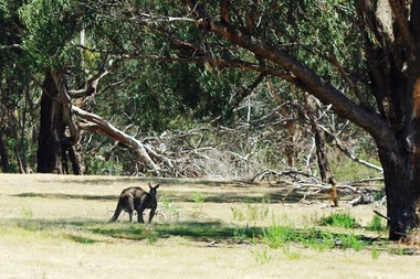
Janefield Precinct: Lone kangaroo. The remains of this site are between Greensborough and Janefield. A RAAF Hygiene Training Camp was located on the Plenty River, just south of the Janefield community. It was in use from 1944 to 1946. The Camp was constructed from salvaged materials. Instruction included building and maintenance of grease traps, latrines, elementary plumbing and carpentry.Early remains of a WW2 training camp Digital colour photograph.raaf hygiene training camp janefield -
 Greensborough Historical Society
Photograph - Digital image, Marilyn Smith et al, Janefield Precinct: Basalt remains, 27/11/2014
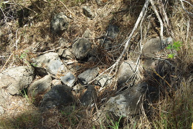
Janefield Precinct: Basalt remains. The remains of this site are between Greensborough and Janefield. A RAAF Hygiene Training Camp was located on the Plenty River, just south of the Janefield community. It was in use from 1944 to 1946. The Camp was constructed from salvaged materials. Instruction included building and maintenance of grease traps, latrines, elementary plumbing and carpentry.Early remains of a WW2 training camp Digital colour photograph. -
 Greensborough Historical Society
Photograph - Digital image, Marilyn Smith et al, Janefield Precinct: Basalt Rubble, 27/11/2014
Janefield Precinct: Basalt rubble. The remains of this site are between Greensborough and Janefield. A RAAF Hygiene Training Camp was located on the Plenty River, just south of the Janefield community. It was in use from 1944 to 1946. The Camp was constructed from salvaged materials. Instruction included building and maintenance of grease traps, latrines, elementary plumbing and carpentry.Early remains of a WW2 training camp Digital colour photograph. -
 Greensborough Historical Society
Photograph - Digital image, Marilyn Smith et al, Janefield Precinct: Grease traps, 27/11/2014
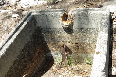
Janefield Precinct: Grease traps. The remains of this site are between Greensborough and Janefield. A RAAF Hygiene Training Camp was located on the Plenty River, just south of the Janefield community. It was in use from 1944 to 1946. The Camp was constructed from salvaged materials. Instruction included building and maintenance of grease traps, latrines, elementary plumbing and carpentry.Early remains of a WW2 training camp Five digital colour photographs. -
 Greensborough Historical Society
Photograph - Digital image, Marilyn Smith et al, Janefield Precinct: Ruined slabs, 27/11/2014
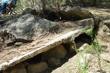
Janefield Precinct: Ruined slabs. The remains of this site are between Greensborough and Janefield. A RAAF Hygiene Training Camp was located on the Plenty River, just south of the Janefield community. It was in use from 1944 to 1946. The Camp was constructed from salvaged materials. Instruction included building and maintenance of grease traps, latrines, elementary plumbing and carpentry.Early remains of a WW2 training camp Digital colour photograph. -
 Greensborough Historical Society
Photograph - Digital image, Marilyn Smith et al, Janefield Precinct: Chimney remains, 27/11/2014
Janefield Precinct: Chimney remains. The remains of this site are between Greensborough and Janefield. A RAAF Hygiene Training Camp was located on the Plenty River, just south of the Janefield community. It was in use from 1944 to 1946. The Camp was constructed from salvaged materials. Instruction included building and maintenance of grease traps, latrines, elementary plumbing and carpentry.Early remains of a WW2 training camp Digital colour photograph.janefield -
 Eltham District Historical Society Inc
Photograph, Main Street, Greensborough, 1920s, 1920s
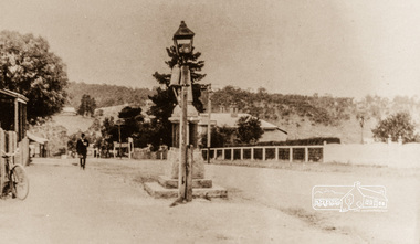
Looking towards the Plenty River from outside the current premises of the State Savings Bank. In the foreground is one of the old carbide street lamps. Behind the lamp is the drinking fountain erected as a memorial to Greensborough's Great War (First World War) Diggers. This memorial is now in the park in Henry Street, (Photo: Nillumbik Historical Society)Colour photograph copy originally located in a magnetic style album titled 'Greensborough Bypass 1990s 5' suffering significant degradation. No information contained in album or on reverse of photos except where noted. Relocated to archival photosafe storage.greensborough, main street -
 Flagstaff Hill Maritime Museum and Village
Equipment - Fishing Gaff, 20th century
A tool produced and used in the fishing industry to assist in retrieving large fish aboard a boat after being hooked on a fishing rod and brought to the vessel's side. Its origin is in 16th-century England river and estuary fishing. It saves the fishermen from leaving the boat and standing in the water to retrieve their large fish from the line.The fishing gaff is an example of equipment used in the fishing industry from around the 16th century that continues to be used today. River and bay fishing has been carried out in Warrnambool from the early to the mid-19th century. Gaff; wooden fishing gaff with a smooth pointed metal hook fixed to the end with black binding.warrnambool, shipwreck coast, flagstaff hill, flagstaff hill maritime museum, flagstaff hill maritime village, fishing gaff, fishing equiipment, fishing industry, rod fishing, river fishing, estuary fishing, fishing tool -
 Bendigo Historical Society Inc.
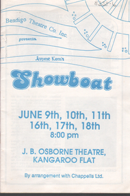
Programme - Bendigo Theatre Company: 'Showboat'
"Showboat" was based on a novel by the same name and follows the lives of the crew and performers on the "Cotton Blossom", a Mississippi River showboat from 1887-1927. The music was written by Jerome Kern and the lyrics by Oscar Hammerstein II. It was first produced by Ziegfield in 1927. It was considered the first of the new genre of Light Opera as opposed to operettas or musical comedies.Bendigo Theatre Co. Inc: Program & 2 X blue colored Tickets (seats L5 & L6 for 16/6/11988) for the production of 'Showboat' White paper program with blue ink writing on front cover. Information on front cover: J. B. Osborne Theatre, Kangaroo Flat for dates of June 9th, 10th, 11th, 16th, 17th & 18th at 8.00pm 10 double sided pages with black & white photos of cast & production team Program made of paper, folded & stapled in the middle.souvenir programme, bendigo operatic society -
 Puffing Billy Railway
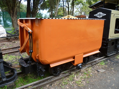
Side Tipping Wagon - W. G. Allen & Sons (Tipton) Ltd
Built by W. G. Allen & Sons (Tipton) Ltd., Tipton, Staffordshire, England. This vehicle was used on the construction of dams, etc., and the Jindivick tunnel at Tarago in Gippsland for the state Rivers & Water Supply Commission of Victoria. The small wheel located on the side ran up a suitably located ramp automatically tipping the hopper and emptying the contents. Historic - Industrial Narrow Gauge Railway - side tipping wagon used by the State Rivers & Water Supply Commission of Victoria - Jindivick tunnel at Tarago, Victoria, AustraliaSide Tipping Wagon made of Iron, steel and wrought ironpuffing billy railway, pbr, side tipping wagon - w. g. allen & sons (tipton) ltd, puffing billy, side tipping wagon, w. g. allen & sons (tipton) ltd, jindivick tunnel, state rivers & water supply commission of victoria -
 Ballarat Heritage Services
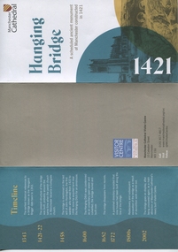
Pamphlet, Hanging Bridge, Manchester, England
Hanging Bridge is a medieval bridge spanning the Hanging Ditch which connected the rivers Irk and Irwell in Manchester. 'For many years the bridge was completely hidden, remembered only in the name of the area where it had stood, until its rediscovery and subsequent excavation as a result of demolition work carried out in the 1880s.' ... More information is on the pamphlet A pamphlet containing images and information about the Hanging Bridge at Manchester Cathedral.Manchester Cathedral Hanging Bridge: A scheduled ancient monument of Manchester constructed in 1421. ... More information and timeline on pamphlethanging bridge, manchester, medieval, manchester cathedral -
 Ballarat Heritage Services
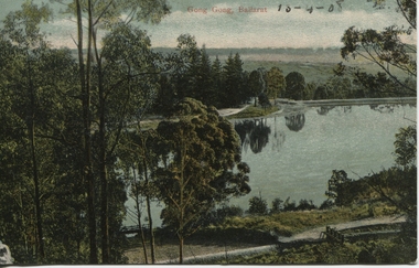
Photograph - Postcard, Gong Gong, Ballarat, 1908
Gong Gong was a locality in Ballarat East, near Fellmongers. A reservoir was built there. Situated only 10 minutes drive from the Ballarat CBD. In 2019 Gong Gong Reservoir Park is set in natural bush surrounds. There are scenics views, picnic and BBQ facilities with toilet facilities available on weekends. It is located along the Yarrowee River.photograph of Gong Gong reservoir 1908Gong Gong Ballarat - 13-4-1908 verso - note to Miss M I Wise, Gutheridge Parade, Salew. hewitt's yarrowee soap works, fellmongery, tannery, gong gong, mair street, daylesford road, o'deas, kinnane's, quin's, nestors -
 Eltham District Historical Society Inc
Photograph, Liz Pidgeon, Heritage Excursion; Eltham Lower Park Walk and Talk, 1 July 2017, 1 July 2017
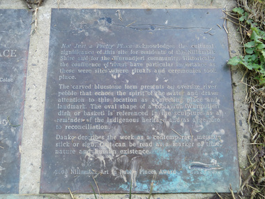
Transcription of plaque: Not Just a Pretty Place acknowledges the cultural significance of this site for residnets of the Nillumbik Shire and for the Wurundjeri community. Historically the confluence of rivers have particular importance as these were sites where rituals and ceremonies took place. The carved bluestone form presents an oversize river pebble that echoes the spirit of the water and draws attention to this location as a meeting place and landmark. The oval shape of a coolamun (Wurundjeri dish or basket) is referenced in the sculpture as a reminder of the indigenous heritage and as a gesture to reconciliation Danko describes the work as a contemporary message stick or sign, that can be read as a merker of time, nature and human existance. 2000 Nillumbik Art in Public Places Award. Heritage Excursion - Saturday 1st July - Eltham Lower Park - Walk and Talk Eltham Lower Park has played an important part in the history of our area since the early days of European settlement when it was used by local residents as an informal racecourse. Prior to that its location at the junction of the Diamond Creek and the Yarra River made it an important meeting place for the Wurundjeri people. The park combines formal elements and sporting facilities with remnant bushland that is of environmental significance. It is home to sporting and horse riding clubs, popular play spaces and the Diamond Valley Miniature Railway, which attracts large numbers of visitors. The park will be the venue for our July excursion which will comprise a walk of about 3.5 km around the park and adjacent areas. Along the way we will discuss the history and natural history of the area. The path along the creek and the river provides a pleasant and scenic walk. This walk on Saturday 1st July is about 3.5 km in length and will take 2 to 2.5 hours. It will start at 2pm at the Main Road car park at the front of the park. (Melway ref 21 H 10). From Newsletter No., 234, June 2017 Born Digitalelection day, heritage excursion, activities, eltham district historical society, eltham lower park, not just a pretty place, public art, plaque -
 Kew Historical Society Inc
Plan, Studley Park Estate, 1910
Prue Sanderson, in her groundbreaking ‘City of Kew Urban Conservation Study : Volume 2 - Development History’ (1988), summarised the periods of urban development and subdivisions of land in Kew. The periods that she identified included 1845-1880, 1880-1893, 1893-1921, 1921-1933, 1933-1943, and Post-War Development. These periods were selected as they represented periods of rapid growth or decline in urban development. An obvious starting point for Sanderson’s groupings involved population growth and the associated economic cycles. These cycles also highlighted urban expansion onto land that was predominantly rural, although in other cases it represented the decline and breakup of large estates. A number of the plans in the Kew Historical Society’s collection can also be found in other collections, such as those of the State Library of Victoria and the Boroondara Library Service. A number are however unique to the collection.The Kew Historical Society collection includes almost 100 subdivision plans pertaining to suburbs of the City of Melbourne. Most of these are of Kew, Kew East or Studley Park, although a smaller number are plans of Camberwell, Deepdene, Balwyn and Hawthorn. It is believed that the majority of the plans were gifted to the Society by persons connected with the real estate firm - J. R. Mathers and McMillan, 136 Cotham Road, Kew. The Plans in the collection are rarely in pristine form, being working plans on which the agent would write notes and record lots sold and the prices of these. The subdivision plans are historically significant examples of the growth of urban Melbourne from the beginning of the 20th Century up until the 1980s. A number of the plans are double-sided and often include a photograph on the reverse. A number of the latter are by noted photographers such as J.E. Barnes.Coloured lithograph of a subdivision plan of the Studley Park Estate, bordered by Yarra, Willsmere Road and the Outer Circle Railway line. The estate was listed in 1910 and was the subject of a planning dispute between the developer and the Town of Kew in relation to flood levels and the suitability of the land for housing. In many cases the names of streets were subsequently changed. The layout was also affected by the creation of the Eastern Freeway. A newspaper report of the day described the subdivision as a: "GOLDEN OPPORTUNITY. We are pleased to submit for PRIVATE SALE that magnificent ESTATE, situated only 4 1/2 miles from the Melbourne General Post Office, STUDLEY PARK ESTATE. KF/NV. Doubtless the CHEAPEST LAND EVER OFFERED having extensive frontages to the prettiest spot on the River Yarra and the National Park, commanding lovely river and landscape views, and acknowledged to be the finest land available so close to the city. The PRICES ARE EXTREMELY MODERATE; The TERMS ARE SIMPLY MARVELLOUS. NO DEPOSIT. NO DEPOSIT. NO DEPOSIT. Allotments and prices to suit everyone."subdivision plans - kew, studley park estate -
 Federation University Art Collection
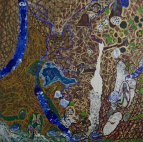
Painting - Artwork, Artwork by Daphne Wallace, 2006
Daphne WALLACE (1964- ) Gomaroi, Ullaroi, Wurralli, Muralli Country Wallace is a Gamilaroi/Ullaroi-Yuwaaliaay artist whose intensely coloured and textured abstract and pictorial paintings are interpretations of the Yuwaaliaay stories passed down to her by her grandmother. They are evocative of her spiritual and emotional attachment to her home in Lightening Ridge.Daphne WALLACE Gomaroi, Ullaroi, Wurraili, Muraili country Artist's statement: This painting tells of many different stories, most of them I knew growing up and some were told to me since working on the Bubbles of the Surface Project. ... Reading this landscape through Murri / Murdi eyes and our relation to country. In the top, Yurri Yurri women/people, Rainbow serpents the other side of Coocoran Lake, Bunyip waterhol near Angledool, Ants nest believed to be where Baiame laid his tow wives, where the ants ate off the slime and brought them back to life, mining fields around Lightning Ridge, Bush tucker such as bumbull, burrigan, nappan, greewee, snotty gubbuls. In the middle, Gurra the crocodile, Gurra the crocodile himself, when Baiame killed him to retrieve the two wives, a rainbow shone no him and his scales turned inot opals, left to the Narran Lake was where Baiame sat down and left his bottom imprinted in the rock. he got up and moved onto the blue mountains where his wives gave birth to the three sisters. At the botttom of the painting, Walgett council dug up two old Kings sitting up face to face with their legs crossed, with their Tin King plates around their necks; Their head bands of kangaroo teeth were still inbedded in their skulls. The water dog stories are at spots along river "don't go down thereon the bend (Namour Researve River) the water dog witll get you" Nan used to tell us. It is believed that the water dog makes whirlpools and will drown you. He makes a druming sound, which can be heard along the Namoir, Barwon, Darling, Gwydir, Mihi and the Narran River; and the Duck is part of the creation story, with the twin platypus. It tells how the water dog kidnapped her and kept her in a cave on the river bank, she escaped back to her people. They knew she was bingal therefore vanished her fro that region, she travelled to New England region giving birth to twin platypus.daphne wallace, aboriginal, gippsland campus, churchill, gomaroi, ullaroi, wurraili, muraili -
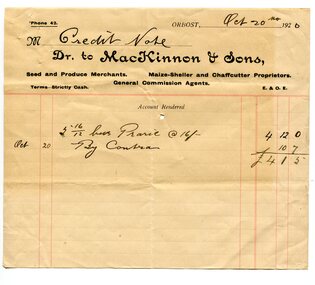 Orbost & District Historical Society
credit note, October 20 1920
MacKinnon and Sons were seed and produce merchants. Mackinnon was the Orbost agent for the Vacuum Oil Co., and his business extended to Cann River, 60 miles away. This item was probably used by Robert Pullar Cameron who was a Shire Councillor for many years. He married Penuel Hossack and had a family of James, Flora, Penuel and Alex. This item is an example of book-keeping for an Orbost business in the early 20th century. It is a useful research tool.A white paper credit note with black print and red lines made out for MacKinnon & Sons, merchants.mackinnon-&-son-seed-merchants credit-note -
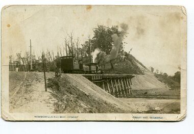 Orbost & District Historical Society
postcard, Vogt. W.S, first half 20th century
This photograph is of a train on the small rail bridge which crosses over the Burn Road Newmerella cutting. In 1912 work was underway to complete the Bairnsdale to Orbost section of the railway. This meant the end of river transport for the area. The railway was opened on April 10 1916 and closed in 1987. The letter written on the card is from Hilda Graham to her uncle.This item is associated with the history of the Orbost-Bairnsdale railway line and therefore reflects the role that the rail line played in the social and economic history of Orbost.A black / white postcard photograph showing a train engine crossing on a small rail bridge. On the back is a handwritten letter.Photo caption - "NEWMERELLA RAILWAY, ORBOST STANLEY VOGT"newmerella east-gippsland-railway -
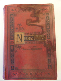 Warrnambool and District Historical Society Inc.
Book, No cross no crown
This book has been given by the Woodford Sunday School to Edith Cassady (note the misspelling of ‘Cassady’). Edith Cassady was the daughter of William and Elizabeth who lived at Boughton on the Merri River (near Cassady’s Bridge, Caramut Road today). This property was established about 1845. The donor of the book was William Wines, a member of a pioneering family in the Woodford district. This book is of some interest as it belonged to Edith Cassady, a member of a pioneering family who lived at Boughton on the Merri River. This is a hard cover book of 344 pages. The cover is red with black border decorations and black and gold lettering. There are several full page black and white illustrations scattered throughout the book which has 23 chapters of story. The cover and pages are much water-stained. The inscription is handwritten in black ink. ‘Woodford Sunday School Presented to Edith Cassidy (sic) by her well-wisher William Wines’ william wines, woodford, history of woodford, edith cassady, boughton property, cassady family -
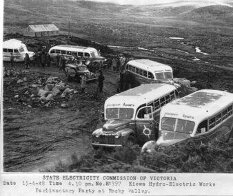 Kiewa Valley Historical Society
Photograph - Parlimentary Party visiting Rocky Valley Dam site, 15-4-1948
This photograph was taken during construction of the Rocky Valley Dam and wall. Work was commenced in early 1947 but had to be suspended during winter and then resumed in October. Work continued in 1948 with the establishment of work facilities and, at the dam site, the river was diverted through a temporary pipeline. Rocky Valley and associated spillway and outlet works were completed in 1959.A pictorial record of the construction of the rock and earth filled dam wall at Rocky Valley. Shows the extent of the project undertaken and the level of importance of the project as indicated by the large representation at the parliamentary party visit on 15/4/48.Photocopy of black and white photograph of parliamentary party visiting Rocky Valley Dam site 15/04/1948Typed on the bottom of photocopy - State Electricity Commission of Victoria. Date: 15-4-48 Time: 4.30pm No: K4397. Kiewa Hydro-Electric works. Parlimentary Party at Rocky Valleyrocky valley dam, parliamentary party, secv -
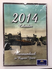 Warrnambool and District Historical Society Inc.
Calendar, Warrnambool in Bygone Years, 2013
This 2014 calendar was produced in Warrnambool and features reproductions of photographs of Warrnambool in past times. The photographs include the Botanic Gardens, the Breakwater, the War Memorial, Proudfoots Boatsheds, Liebig Street, the old Information Pavilion and the Hopkins River near the mouth. The photographs in the calendar come from the collection of the Warrnambool and District Historical Society and were reproduced with the permission of the Society. This calendar is of minor importance but it does demonstrate the popularity of locally-produced yearly calendars and the interest in photographs of times gone. This is a 2014 calendar featuring twelve photographs of Warrnambool in past times. The photographs have been coloured or tinted and the front cover has a copy of the photograph featured for the month of March. The front cover has a brown edging and the inside front cover and the black cover are white. The dates are printed in two colours and vary from month to month. The paper is glossy and the pages have been bound with plastic spiral binding with a tab at the top to append the calendar to a wall. ‘2014 Calendar’ ‘Warrnambool in Bygone Years’ warrnambool photographs of the past, calendar 2014, spectrum print solutions -
 Port of Echuca
Photograph, P.S. Rodney with barges Horace & Nelson, c.1890
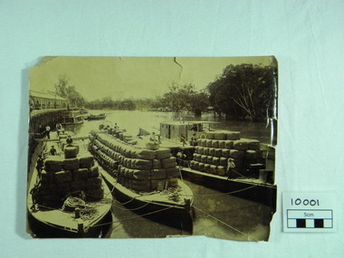
P.S Rodney with barges Horace & Nelson laden with wool bales bought into the Port to be unloaded onto rail trucks to go to markets in Melbourne. c.1890 Paddlesteamers travelled the river systems to bring wool from out- lying properties into the Port of Echuca to be transported by rail to Melbourne. This was prior to road & rail transport in the 1800'sOne of thousands of photos taken depicting the transportation of wool from out- lying properties to the rail head at Port of Echuca using paddlesteamers. P.S.Rodney alongside barges Horace & Nelson, tied to historic Echuca Wharf, with Pride of the Murray paddlesteamer & barge in back ground all vessels loaded with wool bales and crew resting on these. Riverbank lined with red gums. Handwritten in pen on lower left back corner "Rodney with barges Horace & Nelson c. 1890"farming, economy, p s rodney, port of echuca, wool bales, wharf, barges, horrace, nelson, paddlesteamer rodney, echuca -
 Port of Echuca
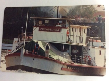
Photograph - Coloured photograph, March 1984
This photograph was taken in February 1984 on the occasion of Cossen's visit to Echuca. It is a close up of the wheelhouse of the P.S Pevensey with the name Philadelphia written across the wheelhouse. This is significant because the P.S Pevensey played the role of the P. S Philadelphia in the movie "All The Rivers Run" which was filmed in Echuca in late 1982 and a sequel was filmed in Echuca early in 1989.This photograph is significant because it shows the P.S. Pevensey showing the name P.S Philadelphia. The P.S Pevensey was used as the P.S Philadelphia in the TV Series "All The Rivers Run" based on the novel written by Nancy Cato. The TV series was a huge success and still draws tourists to the Port of Echuca. The fact that the P.S Pevensey was showing the Philadelphia name in 1984 is a bit of a mystery, but it has been known that she was dressed up again as the P.S Philadelphia sometimes for special occasions. The Cossen's visit to Echuca might have been such an occasion. It also shows the Echuca Wharf with a train parked there, and the Customs House can be seen in the background as well.A close-up image of the P.S. Pevensey travelling upstream away from the Echuca Wharf. There are five people in the wheelhouse; a dark haired young woman and a man in a suit and tie, two crew and there are two men standing with their backs to the photographer, on the lower deck. Three people can be seen near the fire box underneath the wheelhouse. The Echuca Wharf can be seen in the background. p.s pevensey, greenspot photography, murray river, echuca, la grue, bill, cossen's visit to echuca., all the rivers run, p. s philadelphia, cossen family, echuca wharf -
 Warrnambool and District Historical Society Inc.
Map - Fire Maps, Region 5 Fire Control Map, 1963
Two fire maps of south west Victoria.1 This is a rectangular piece of linen folded several times to form a packet with the front part covered with a brown card. The cover has a blue and white label. The map has a white base with red and green markings and red and black printing .2 As .1 abovenon-fictionTwo fire maps of south west Victoriafire maps, warrnambool history -
 Eltham District Historical Society Inc
Album - Photograph, J.A. McDonald, Eltham-Greensborough Road, 18 Oct. 1956
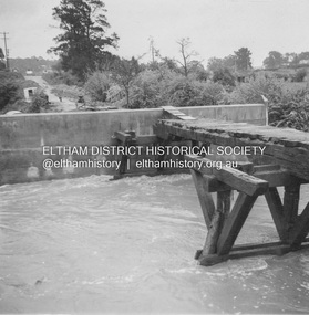
Bridge Street Bridge Flood level on Eltham pier 18th October 1956 Looking west across the Diamond Creek to Susan Street intersection Beware!.. our rivers are rising (1956, October 19). The Argus (Melbourne, Vic. : 1848 - 1957), p. 1. Retrieved August 24, 2022, from http://nla.gov.au/nla.news-article84392304Record of various Shire of Eltham infrastructure works undertaken during the period of 1952-1962 involving bridge and road reconstruction projects, sometimes with Eltham Shire Council Project Reference numbers quoted. It was during this period that a number of significant improvements were made to roads and new bridges constructed within the shire that remain in place as of present day (2022). In many situations, the photos provide a tangible visible record of infrastructure that existed throughout the early days of the Shire. The album was put together by or under the direction of the Shire Engineer, J.A. McDonald.infrastructure, road construction, shire of eltham, bridge construction, bridge street bridge, eltham, eltham-greensborough road, 1956-10-18, diamond creek (creek), floods, floodwater, silver street bridge -
 Greensborough Historical Society
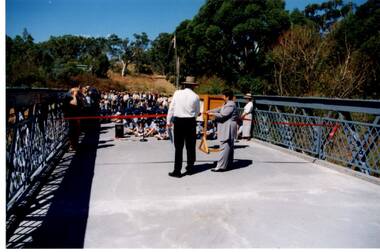
Photograph - Digital Image, Anne Paul, Opening of restored Old Lower Plenty Bridge 2001, 14/03/2001
The opening of the restored Old Lower Plenty Bridge, opened on 14/03/2001 by the Minister for Environment and Conservation Sherryl Garbutt MLA and Mayor of Banyule Cr Dale Peters. The project was jointly funded by Banyule Council and Parks Victoria. The restored bridge is the oldest remaining bridge in the former Shire of Eltham and forms part of the Plenty River Trail.Digital copy of colour photographlower plenty, lower plenty bridge, sherryl garbutt, dale peters, banyule council, parks victoria -
 Greensborough Historical Society
Newsletter, Plenty Gorge Metropolitan Park Newsheet No. 1 August 1989, 1989_08
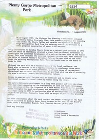
The Shire of Whittlesea obtained a grant from the federal government to investigate the potential development of a park to the west of the Plenty River in 1976. A regional tip site and the Shire of Diamond Valley's Yarrambat Park were handed over to the MMBW to form the existing Metropolitan Park in 1986. A long term project to develop the park further is to commence in 1990.2 p. text, map and col. illus."With compliments of Sherryl Garbutt M.P. Member for Greensborough" (rubber stamp)plenty gorge park -
![Photograph - Digital image, Familie Bosch Australien [Bosch/Bush], 1910c](/media/collectors/4f729f5697f83e03086015b8/items/5441ba832162f10c081eab62/item-media/5441bae12162f10c081eae58/item-fit-380x285.jpg) Greensborough Historical Society
Greensborough Historical SocietyPhotograph - Digital image, Familie Bosch Australien [Bosch/Bush], 1910c
Johannes Bosch and family migrated from Southern Germany to Greensborough district. They farmed along the Plenty River having purchased land from Flintoff. Johannes Bosch came to Australia in 1884 aged 17. He married Henrietta Duck, had 3 children and divorced in 1903. Around 1902 he anglicized the family name to Bush.Digital copy of black and white photograph.johannes bosch, bosch family, bush family