Showing 1076 items
matching bridges and buildings
-
 Melbourne Tram Museum
Photograph - Set of 5 Black & White - First AETA tour, 15-2-1947
Set of five photographs of the first Australian Electric Traction Association (AETA) tram tour of Melbourne on 15/2/1947. See page 8 of the March 1947 issue of "Tram Tracks" for details of the tour and the MMTB Crew. 1 - SW6 881 about to leave Glen Huntly Depot 2 - Crossing Balaclava Junction 3 - Crossing the Kooyong railway level crossing in Glenferrie Road - has the railway signal box and gates in view. 4 - Turning into Riversdale Road from Glenferrie Road with the Stotts Business College building in the background. 5 - Just to the east of Yarra River Bridge in Swan Street with the Burnley Gardens on the right.Yields information about the first AETA tram tour in 1947Set of 5 Black and white photograph on paper. Two copies of each held.Each one of the set has a photographers file stamp on the rear, but no details filled in.trams, tramways, aeta, tram tours, tram 881, sw6 class, glen huntly, kooyong level crossing, glenferrie road, riversdale road, burnley, hawthorn, balaclava junction, glen huntly depot, hawthorn road, swan st -
 Melbourne Tram Museum
Slide - Set of 4, Vic Solomons, Jun. 1970
Slide - set of 4 - 35mm - Kodachrome cardboard mounts. .1 - Tram 808 at the Spencer St stop at the corner of Bourke St with Spencer St Station in the background. Note the route and destination - at the time when North Balwyn and Burwood Routes were combined on Sundays am and evening - and passengers changed at Hawthorn Bridge. Route 74. Has a Fosters Lager advertisement. .2 - As above, tram approaching the stop with the Spencer St station car park in the background. .3 - tram 1005 leaving the Bourke St terminus, taken after .4 .4 - tram 1005 at the Bourke St terminus with tram 838 crossing in the background, has the Station building, Carlyon's Hotel and the Tramways Building. Note the Bundy clock, tram stop signage and safety zone. Route 96. The grey box by the Bundy Clock is thought to be a correspondence box for the satchels that were transported between the depots and head office. Photographed by Vic Solomons June 1970 (based on date stamped on slide)trams, tramways, bourke st, spencer st, railways, stations, route 74, north balwyn, burwood, route 96, letters, mails, tram 808, tram 1005, tram 838 -
 Kiewa Valley Historical Society
Photographs – Set of 4 black and white photographs. One of a wooden church and three of rural homes and farmland. Area not identified
Europeans arrived in the Kiewa and Ovens Valleys in the 1830's and 40's. Following the drought of 1838-44, seeking out the rich pastures in the fertile Valleys. It proved to be perfect conditions for dairy farming and the raising of cattle. Miners Cottages and other similar wooden structures were a common sight in the area as they were a modest form of accommodation for their period, were quick to erect and economical as they made use of locally available building materials such as local timbers.These photographs provide a snapshot into the early dwellings and architecture of the Kiewa and Ovens Valley regions, including buildings such as the church, which provided an important gathering place for social interaction, especially in these isolated areas.1-Wooden church building with no identification. Large tree in the foreground in front of church 2&3- Black and white photographs of farmland and assorted dwellings, mostly miners style cottages in a valley with mountains in the background. A bridge with wooden railings is visible over the river in the middle of the photograph, also a more modern dwelling is visible in the north east of the photograph close to the river. 4-Black and white photograph of residential homes and farmland with an unsealed road running through the middle. Foreground shows a field which has been semi cleared of trees (stumps remaining). In the background are larger farming properties with the road disappearing into the distant hills. This might be Old Tallangatta before the town was moved in 1956. 1-3 - No inscriptions 4- Signature written on back in lead pencil - Sandra Templebuildings; church; farmland -
 Mission to Seafarers Victoria
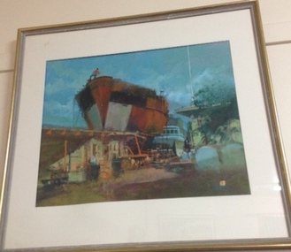
Painting, (Dry dock), Late 20th C or early 21st Century
Marine art, Maritime artLarge framed glazed landscape format painting depicting in foreground a rusty hull of a ship against a deep aqua blue sky. The hull appears to be in a dry dock with a stylized figure with a red top and blue pants looks down from the prow at the set of low buildings and yard in the foreground. Another ship appears to be moored behind the rusty hull but only the bridge of the ship is visible. At near right in foreground there appear to be two rounded graves or headstones.The frame is sharply beaded and with gilding. The painting has a window mount and is glazed with glass. Paint surface is thinly but intensley painted and seems to be gouache or watercolour on paper. Sealed at back with brown paper mostly intact and a corded hanging system.at lower right corner quadrant there seems to be a mainly rectangular ciphertankers, marine painting, artwork-paintings -
 Melbourne Tram Museum
Document - Radio Transcript, Melbourne & Metropolitan Tramways Board (MMTB), "Wireless Talk -- Mr. J. D. Barton Staff Officer MMTB - Melbourne Street Transport No. 2", late 1920's
Radio Transcript or script, 7 foolscap typed pages, double spaced titled "Wireless Talk -- Mr. J. D. Barton Staff Officer MMTB - Melbourne Street Transport No. 2". Report looks at the history of horse bus routes in Melbourne, building of the cable trams, the Parliamentary Bills for the cable trams, constructing the lines, Mr. G. Duncan, Mr. Clapp, construction difficulties, the Melbourne Tramway Trust, MTOC, drainage issues, bridges, alterations to the Act, Patent issues with a London company, opening dates and comments about wire rope. Could be a few pages missing given the way it ends, no thank you or formal ending. Item noted dated, presumed late 1920's.Has pencil notation in top left hand corner "6 copies"trams, tramways, public transport, radio stations, horse buses, mto co, melbourne, cable trams, mtt -
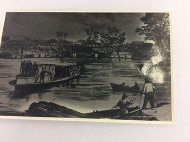 Port of Echuca
Black and white photograph of an engraving, Approximately 1970
This is a photograph of an engraving showing the first train arriving at the Echuca Wharf on 25/09/1865. The photograph appeared in the Illustrated Australian News on 25/09/1865. It also appeared in Susan Preiestly's book, 'Echuca; A centenary history' in 1965 on page 46.. The picture is of interest because it shows the size of the wharf in 1865. It also shows all the crowds to welcome the first train. It also shows the buildings along Murray Esplanade. In the far left the Steam Packet Hotel, Shackell's Bond Store and the St George's Hall, next the The Bridge Hotel. Five large steam ships are visible, all carrying crowds of people. In the foreground is the S.S Melbourne. Two rowing boats are in the left foreground.This engraving is significant because it shows the welcoming of the first train onto the wharf. The photograph shows the size of the wharf in 1865, as well as the street scape and the vessels on the water at the wharf. There is also some activity at Evan's sawmill. There are crowds on the wharf, and lining Murray Esplanade. It also shows that most of the crowd are males, which helped describe the role that women played in public life in the 1880's. A black and white photograph of an engraving of a busy Echuca wharf scene in 1865. The first train is arriving at the wharf. There are crowds of people, and in the foreground is the S.S. Melbourne. On the front of the photograph in the bottom right hand corner are the letters R.G. (Is this the Artist's initials?) On the back of the photo, written in pencil are the words "Day first train came through to the wharf. Of interest because of buildings far left. Steam Packet 1865. From Ilustrated Australian News. 25th September 1865."echuca wharf, susan preistley, railways, state library of south australia., illustrated australian news., s.s.melbourne, steam packet hotel, shackell's bond store, st george's hall, bridge hotel -
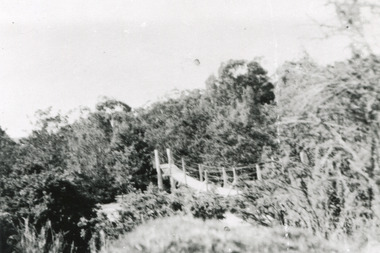 The Beechworth Burke Museum
Photograph
This rectangle black and white photograph shows a bush scene with part of a suspension rope and wooden plank bridge visible in the middle of the image. It is likely this suspension bridge was used by the Tannery workers to move between the town and the Ovens Tannery located South-West of Beechworth due to its secluded bush location, the bridge likely spanned the gorge across Spring creek. The tannery itself was located alongside Gimlet Creek, about three kilometres from town, down what is now known as Malakoff and Old Tannery Road but which at the time was remote and accessed through bushland. The Ovens tannery was stablished in 1858 by Matthew Dodd and Hallahan and later Matthew and his brother Thomas Dodd in 1866 who developed it over the years. According to Doyle, 'we have little information about its early operations except the tannery itself comprised four small buildings' by 1870 ‘a small village with gardens of vines and fruit trees surrounded the tannery’ (Woods, 121), and by 1887 the Tannery employed fifteen men. The Ovens tannery was among several new businesses establishing themselves such as a foundry that brought industrial manufacturing alongside the developing township and which strengthened the economic stability of Beechworth after the receding mining surge. According to Woods (p. 121) in the 1860’s the government spent considerable sums to establish several public buildings such as the Benevolent Asylum, the Hospital and Insane Asylum to support those in need of care in the area directly after the Indigo gold rush which had left Beechworth, a fairly remote regional and newly formed township (Gold was first discovered in Beechworth in 1852) with a number of infirm and destitute people in its wake and which due to the support and establishment of these facilities ‘made Beechworth a significant social welfare centre in Victoria’ (Woods, p. 121). The tannery provided employment and connected the regional centre with other parts of Victoria and the wider colonial outposts and would have been a welcome opportunity for those seeking work after gold was no longer a source of income.A good example of the ingenuity of regional settlers to achieve what would have been a difficult and remote construction of a bridge as a means of access. This bridge is evidence of planning and forethought and shows dedication to establishing a life in a remote landscape.Black and white rectangular photograph printed on paperreverse: / 2983 / / BMM2983 /black and white photograph, bush, suspension bridge, rope bridge, tannery, spring creek, ovens tannery, bushland, gimlet creek, matthew dodd, beechworth -
 Eltham District Historical Society Inc
Negative - Photograph, Rose Stereograph Company, The Bridge, Hurstbridge, Vic, c.1925
Copied from brochure "Wattle Valley Estate". The new bridge designed by Sir John Monash over the Diamond Creek near Hurst's original home "Mia Mia" seen in the distance. Reprinted from brochure advertising "Wattle Valley Estate" 7 minutes from bridge. The Wattle Valley Estate was first advertised in August 1925 as weekend building allotments by the Greater Melbourne Land and Development Company. Advertised from £28.10.0 or £60 per block. In August 1926, 30 picked allotments of 60x150 feet were put up for auction Saturday August 14, 1926 with frontages to Valley View Road and Fawkner Crescent advertised in the “Heart of the Glorious Wattle Country” and “Within 15 Minutes of the Newly Electrified Railway Station”. The Advertiser on August 13, 1926 in an article promoting the auction stated “the estate is regarded as one of the best in the district, and will be sold practically without reserve.” It is noted that an advertisement running in The Argus February 22, 1951 offered the remaining 16 blocks for sale at £12.10.0 or £200 the lot. By March 7, the remaining blocks were advertised at £17.10.0 The Wattle Valley Estate took over 20 years to sell and then people could not build on them This image was also used in a brochure advertising the "Wattle Valley Estate", which forms part of the Shire of Eltham Pioneers Photograph Collection (Cross Reference Photo No.(s): 1056, 1057). Also cross reference SEPP_1028 / 29 for other views of Mia Mia. Part of a slide show presentation "Bridges & Waterways of the Shire" by Russell Yeoman to the 13 September 1989 Society meeting. The presentation included slides of historic photos from the Shire of Eltham Pioneers collections as well as several recent views. This photo forms part of a collection of photographs gathered by the Shire of Eltham for their centenary project book,"Pioneers and Painters: 100 years of the Shire of Eltham" by Alan Marshall (1971). The collection of over 500 images is held in partnership between Eltham District Historical Society and Yarra Plenty Regional Library (Eltham Library) and is now formally known as the 'The Shire of Eltham Pioneers Photograph Collection.' It is significant in being the first community sourced collection representing the places and people of the Shire's first one hundred years.Digital image 4 x 5 inch B&W Negshire of eltham pioneers photograph collection, hurstbridge, mia mia, bridge, diamond creek (creek), monash bridge, wattle valley estate -
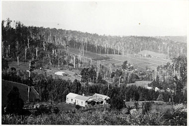 Mt Dandenong & District Historical Society Inc.
Photograph, The Settlement of Harmony Vale 1913, 1913
View of the settlement of Harmony Vale taken in 1913 with the guest house Kia Ora, built by George Barber in 1909, in the foreground. This photograph has a detailed inscription on the back handwritten by John Lundy-Clarke.The settlement of Harmony Vale 1913. The large home in foreground is the Guest House “Kia Ora” owned by George Barber on Lot 25 of the Village Settlement. The house above it to the left was Richardson’s house. The home of Jeanie who had left it when the picture was taken.The buildings furthest to the right of “Kia Ora” were the homestead of Isaac Jeeves of 1863 – 1871 the building furthest right with the black opening in it was the house with the tree fern floor. The flat ground above and left of Isaac’s pointed roof barn is where the creek changed its course in the 1934 flood and destroyed £4000 worth of the Rowse family’s tulip bulbs. Above the flat is Francis Matthew Child’s homestead, in the creek to the right of which can be seen the horizontal structure of the swing bridge to the sawmill of the Childs Bros which cannot be seen but in the forest to the right of the mill (bridge) can be seen a number of logs in the mill yard. The two cleared strips immediately behind Childs home were the Richardson’s original holdings and the house in the gully at the far side of the great clearing is that of the guest house “Glenrivers” belonging to W Lucas and his wife Catherine nee Child. The Richardson homestead “Harmony Vale” is behind the forest trees in the right centre. The picture gives a full view of how the settlement was cut into the centre of the great forest. george barber, kia ora, harmony vale, barber, jeanie richardson, richardson, child, matthew child, kia-ora guest house, guest house, glenrivers -
![Photograph - Digital image, House St Helena and Diamond Creek Roads [Greensborough], 02/05/2013](/media/collectors/4f729f5697f83e03086015b8/items/5729bbd22162f108e8de5be2/item-media/5729bc112162f108e8de617d/item-fit-380x285.jpg) Greensborough Historical Society
Greensborough Historical SocietyPhotograph - Digital image, House St Helena and Diamond Creek Roads [Greensborough], 02/05/2013
These photographs of the house on the corner of St Helena and Diamond Creek Roads was taken in 2013 to show changes over 40 years, based on Ron Reynold's sketches in the 1973 publication 'Greensborough and Greenhills' published by Cypress Books... which states "Built on a steep hill in a bush setting in the early 1920s, for a Dr Wood, the weatherboard house now overlooks an area of activity and change. The owners, Mr and Mrs E. 'Bluey' Blackburn, remember when their 3/4 acre building block dropped to the edge of a dirt road. Today the view from the high verandah encompasses the Main Street shopping centre, new and old bridges, new roads and houses, the Plenty River, natural bush, hills and sports grounds."Digital copy of colour photograph.greensborough and greenhills, st helena road greensborough, diamond creek road greensborough, wood family, ron reynolds -
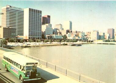
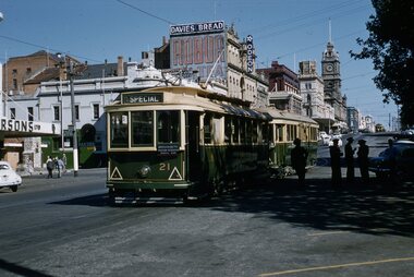
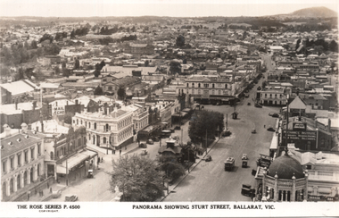 Ballarat Tramway Museum
Postcard, Rose Stereograph Co, "Panorama showing Sturt Street, Ballarat Vic.", 1940s
The photo is a Panorama showing Sturt Street, taken from the Town Hall, looking north east with Mount Warrenheip and Black Hill in the view. Shows the buildings east of Lydiard St, including Bridge St, Camp St and part of Victoria St. One tram is westbound, about to cross Lydiard St. Rose Series P4500. Has signs for the "Mail Echo", Plume petrol, ANA, the Mechanics Institute, and Longhurs Bread. On the rear Wal Jack has written extensive notes for Ken Magor noting the streets in the view and the Ballarat East loco depot and Goods shed. Wal has dated the photo 1940 to 1944, though the trams do not have white bumper bars that featured from 1941 to 1945.Yields information about Ballarat during the 1940sPostcard black and white, divided back, with a handwritten note on rear.See image 2 for details of the handwritten note by Wal Jack on the rear. tramways, trams, bridge st, sturt st, ballarat east, rose postcards -
 Bendigo Historical Society Inc.
Document - GOLD RUSHES AROUND BENDIGO
Typed and hand written notes on 'Gold Rushes around Bendigo', Eaglehawk Police Station, Bells In and Around Bendigo, Bendigo Historical Society Newsletter, Mr Henry Jones - Gold Buyer, and Sir John Quick. Gold Rushes Around Bendigo tells of some gold finds around Bendigo. Eaglehawk Police Station tells of the Building of the Log Lockups at Eaglehawk and White Hills and where the idea came from. Also the cost of building and source of logs. Bells In and Around Bendigo tell of a tram employee ringing a bell and shouting to all that the tram terminus at the Railway Station was discontinued. When this was sufficiently known the bell went to the Bridge Street Methodist Church. The BHS Newsletter mentions business men's names and connection with their trade. Mr Henry jones - Gold Buyer mentions where his office was and that you could buy gold and money could be exchanged as well. Sir John Quick page tells of the early life of Sir John Quick and his self-education, of the A. N. A. opening in Victoria.document, names of bendigo pioneers, bendigo goldfields, gold rushes around bendigo, caltex oil co, matt egan, thos fleck, knight's brick kiln, water commission, work shops, l king, r king, j mumberry, a kelly, 'auld dart', robert fallon, mrs jane stinton, joch, vol 1 gold nuggets literary society files (manuscript written 1852-1882.), john o'c hattam, eaglehawk police station, mr w perry, log lock-ups, john fry, charles fry, bendigo advertiser 30/3/1949, alex h stone, bendigo advertiser 20/41949, milburn's coffee palace, shell service station, bridge street methodist church, mr don hargreaves, bendigo historical society newsletter, mr buzza, mr ankle, mr foote, mr scales, mr bull, mr mutton, mr body, mr satori, mr tankard, mr punch, mr snowball, mr sweet, mr goody, mr pallett, mr frame, mr henry jones, bendigo advertiser centenary of bendigo supplement 1951, sir john quick, a w llewelyn, australian natives association, friendly society, virginia battery, commonwealth parliament, federation league, mr alfred deakin, mr d'esterre taylor, mr peacock, mr barret, mr george reid, corowa conference 1893, poet gay, bendigo cemetery, centenary history ana 1871-1971, john e menadue -
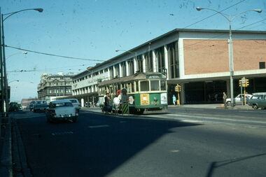
 Melbourne Tram Museum
Postcard, Murfett Publishers, MMTB Bus 583 AEC Mk111 no 583, early to mid 1970's
... Bridges ...Postcard - full colour, Divided back type of MMTB Bus 583 AEC Mk111 no 583 Reg : AT083 entered service 1953 body by Martin and King - two man crew, 41 seats. Notes from Rod Atkins 24/5/2019: Bound for : "Fisherman's Bend via Williamtown Road" on Spencer Street Bridge heading south. When: It's what is missing in the photo gives us a the clue. It after 1968 as the new Stock Exchange building at 357 Collins Street is completed. but before 1973 when the new MLC building was open at 303 Collins Street on corner of Elizabeth Street. But the "2" between the destination and route number boxes on bus tells us its after November 1970. Therefore I would date the post card photograph to around 1971-1972 and prior to the start of the third viaduct between Flinders St and Spencer St. Published by National View by Murfett Publishers Australia. Has the details on the rear with place for stamp, address etc and logo.trams, tramways, king st, bridges, railways, buses, fisherman's bend -
 Ballarat Tramway Museum
Slide - Set of 7, Warren Doubleday, Ballarat - last Saturday of full operations, 21/8/1971
Photos taken on the last Saturday of full operations by the SECV in Ballarat prior to the first closure of the Victoria St line on 22/8/1971. 1 - Trams 26 and 42 turning from Sturt into Lydiard St North - Has the Berry Anderson, Chinese cafe, George Oyster Bar, Gemmola's Pharmacy and the Town Hall in the background. 2 - Trams 39, 26, 42 and 14 in Lydiard St North for the ARHS/TMSV joint Ballarat tour - has the Provincial Hotel and SF Motors buildings in the photo. 3 - Tram 27 to Lydiard St North with Reid's Coffee Palace, Macleod & Co, J J Coller & Co buildings in the background. 4 - Tram 12 inbound crossing the railway tracks 5 - Tram 13 and milk cart - Wendouree Parade. 6 - Tram 11 turning from Wendouree Parade into Macarthur St View Point. 7 - Trams 17 and 11 - Stones Corner - Victoria St and Bridge St. with K & O Schonell sports store, Marios Fruit shop, Gear Chemist and Bank of NSW in the background. Yields information about the last full Saturday of SEC Tramway operations in Ballarat and has a strong association with the archivist. Set of 7 Kodachrome colour slides - cardboard mountsHave the photographer's slide numbers written on them.trams, tramways, closure, level crossing, lydiard st north, tram 26, tram 42, tram 14, tram 27, tram 12, tram 13, tram 11, tram 17, stones corner, bridge st, view point, wendouree parade -
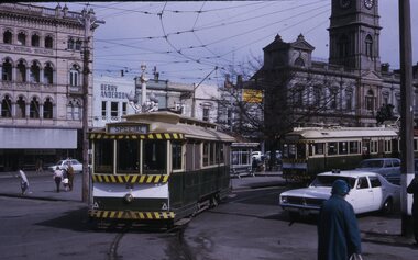
 Ballarat Tramway Museum
Photograph - Illustration/s, Ballarat Views, 1950's mid
Single sheet of printed paper, collected from a magazine (p59/60) with two black and white photos of Ballarat and one colour of Bendigo. Photo 1 - 260mm long x 122mm high, photo of north east Ballarat from Town Hall, looking out to Black Hill. Photo similar to Reg. No. 102, but buildings on corner of Grenville and Bridge St has a Plume sign instead of a Mobilgas Ad. This indicates early to mid 1950's. One tram in loop in one in Bridge St. Also has a "Neptune" sign in photograph. Photo 2 - 195mm long x 75mm high - from north east corner of Sturt and Lydiard Sts looking towards Town Hall and Craig's Hotel. Photo includes SEC bogie at tram stop and the front end of bus travelling east in Sturt St. Photo 3 - 230mm long x 156mm high - colour printed photo of Pall Mall, Bendigo from west side (by Post Office), looking towards the Shamrock Hotel. Photo includes signs for "COR Motor Spirit", "Tanox Paint" and the rear of a Bendigo to Huntly bus. See item Reg. No. 102trams, tramways, ballarat, bendigo, pall mall, oil companies -
 Warrnambool and District Historical Society Inc.
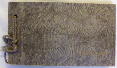
Album - Family photo album, Photograph album, Circa 1954
This album shows a collection of photographs some of which are labelled as Munster Services Club. Some show the Bookshop at the TOC H building. There are photos of soldiers in parade drills and in training exercises as well as social events. One is labelled D Craven & Rab, Munster 1954. Another is labelled London bus 2 RTR Munster. The 2 RTR was a tank regiment in the British Army and was stationed at the Swinton Barracks in Munster from 1952-1959. There are also a number of loose photos showing local scenes such as London Bridge and Needle Rock at Childers Cove. Others depict floats in a parade showing Peace Woollen Mill. Others are small postcards of MaryBorough and Brisbane Queensland. There is also a photograph of the Nestanglo basketball team, Victorian champions circa 1940’s. This collection of photographs has limited local relevance as there is limited provenance. However it depicts quite well the activities of the RTR and their activities in Munster in the post WW era.Brown and fawn snake skin patterned card cover with fawn cord binding. Photographs written in gold on front cover. Pages are brown card. Photographs are black and white.Munster Services Club.warrnambool, swinton barracks munster, munster services club 1952-1959, 2rtr munster -
![Photograph - Digital image, Kelly Garden Supplies [Greensborough], 02/05/2013](/media/collectors/4f729f5697f83e03086015b8/items/5729bced2162f108e8de6b52/item-media/5729bd212162f108e8de74aa/item-fit-380x285.jpg) Greensborough Historical Society
Greensborough Historical SocietyPhotograph - Digital image, Kelly Garden Supplies [Greensborough], 02/05/2013
This photograph of the former site of Kelly Garden Supplies was taken in 2013 to show changes over 40 years, based on Ron Reynold’s sketches in the 1973 publication “Greensborough and Greenhills” published by Cypress Books. The site is now part of the Civic roundabout at the top of the Greensborough By-pass. Civic Drive was associated with the building of Diamond Valley Council Offices opened by Governor Rohan Delacombe on 26/2/1972. Previously it was known as Kelly's Track which wound its way around to a house that overlooked the aqueduct bridge. Kelly's Sandpit (quarry) was the local go to place to obtain road, driveway fill and red sand for local construction. For 80 years previous Kelly's quarry supplied sand to the greater Melbourne area for the surfacing of school grounds, parks etc. Digital copy of colour photograph.greensborough and greenhills, civic drive greensborough, kelly garden supplies, ron reynolds -
 Melbourne Legacy
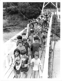
Photograph - Junior legatee outing, Somers Camp 1979, 01/1979
... bridges ...A photo of a large group of children crossing a bridge enroute to the beach. It came from an envelope with other camp photos. The Legacy envelope was marked "P6 Junior Legatee Camps and Hols" in red pen, and dated Jan 1977 in pencil. The contents will be items 00418 to 00425. Melbourne Legacy provides camps for junior legatees. The camps gave the children an opportunity of a summer beach holiday with other Legacy children. It started with outings to the property of Legacy founder, Legatee Stan Savige, who had a place in Balnarring. close to the beach. Permanent camp buildings were built in 1930. In 1930 Lord Somers (Governor of Victoria) also started a camp at a nearby property and the area was renamed Somers. Legacy Somers Camps continued intermittently at Stan's property until it was decided in 1951 to make other arrangements for holidays. A record of Junior Legatee camps.Black and white photo of children crossing a bridge at the beach.Handwritten on back "Jan 1979" in blue pen. Stamped "The property of Melbourne Legacy" in purple ink. Stamped "Copyright The Herald and Weekly Times" in blue ink. junior legatee outing, bridges, beach, somers camp -
 Otway Districts Historical Society
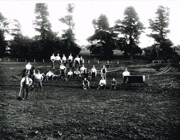
Photograph, Narrow gauge construction camp near Colac, c.1900
Construction of the Colac-Beech Forest railway line commenced in 1900 and the first activities were the work gangs and their camps. About 100 men were engaged in laying and ballasting the track while others formed the earthworks and the building of culverts and bridges. The first camp was established eight kilometres from Colac, the second 12 km south, and the remainder spaced at similar distances as the work progressed. The camps were served by butchers and bakers from Colac that visited them as many times each week to satisfy the mens' requirements. Many of the men had their families with them. They all lived in tents that consisted of a wooden floor around which the canvas cover was built. A calico partition divided the eating and sleeping quarters, and all cooking was done in camp ovens or at open fires.B/W. 158mm x 203mm. Near Colac, a narrow gauge construction camp comprising 21 workmen, a horse, and two tipping trays.construction camp; railways; colac; -
 Wodonga & District Historical Society Inc
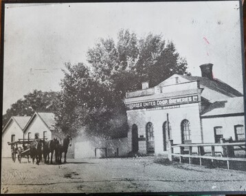
Photograph - Border United Co-op Breweries
The Border United Co-operative Breweries Limited was formed in 1911 by the amalgamation of The Albury Brewing and Malting Company Limited and The Anglo-Australian Brewery Company Proprietary Limited which operated breweries in Beechworth, Tallangatta and Yarrawonga. The Anglo-Australian Brewery was owned by the Billson family. By August the new plant was operating near the Union Bridge on the border of Victoria and NSW as shown in this photo. However the enterprise failed in August 1914 when not enough co-operative shares could be sold and also due to declining water quality. In December 1914 its spirit merchant’s license was transferred to the newly established Murray River Proprietary Company. In 1922, the brewery and 32 acres of land was sold to Mr E E Waite. Waite sold the buildings for removal.This image represents buildings related to early industries in the Albury-Wodonga region.Black and white image of brewery buildings. The image has been mounted on board.On building wall: "The BORDER INITED CO-OP BREWERIES LTD/LICENSED BREWERS"breweries northeast victoria, murray breweries, manufacturing history albury wodonga -
 Flagstaff Hill Maritime Museum and Village
Document - Map, Department of Lands & Survey, Victoria / Panmure, 1942
This Emergency Edition of the map of Panmure, Victoria, is part of the W.R. Angus Collection. It was printed in 1942 during World War II. It is one of two maps donated to Flagstaff Hill Maritime Village by the family of Doctor William Roy Angus, who served as Surgeon Captain in the Australian Defence Department. The map was compiled for the Dept. of Army by the Dept. of Lands and Survey in Melbourne, prepared by the Australian Section of the Imperial General Staff, which was a British Government body created in 1907 to co-ordinate the defence of Britain and its Empire. It was printed by A.H.Q. Cartographic Company, Survey Corps, which was formed in 1941. The Corp changed its name to L.H.Q. Cartographic Company of Bendigo. In 1947 the name reverted back to the A.H.Q. Cartographic Company until 1955 when it became the A.H.Q. Survey Regiment. The W.R. Angus Collection includes historical medical equipment, surgical instruments and material once belonging to Dr Edward Ryan and Dr Thomas Francis Ryan, (both of Nhill, Victoria) as well as Dr Angus’ own belongings. The Collection’s history spans the medical practices of the two Doctors Ryan, from 1885-1926 plus that of Dr Angus who began practice in 1924. Dr. Angus served with the Australian Department of Defence as a Surgeon Captain during the Second World Was from 1942 to 1945. He served in Ballarat, Victoria, and in Bonegilla, N.S.W. until he suffering from a heart attack just before the war ended. ABOUT THE “W.R.ANGUS COLLECTION” - Doctor William Roy Angus M.B., B.S., Adel., 1923, F.R.C.S. Edin.,1928, was generally known as Dr Roy Angus. His working life included a position as a doctor with the Flying Doctor Service in Australia’s rural and remote areas. After many varied experiences Dr Angus and his family moved to Warrnambool in 1939 where he purchased “Birchwood,” the 1852 home and medical practice of Dr John Hunter Henderson. He was appointed on a part-time basis as Port Medical Officer in Warrnambool and held this position until the 1940’s when the government no longer required the service of a Port Medical Officer. Dr Angus was a surgeon at the Warrnambool Base Hospital 1939-1942. After further studies he commenced practice as an ophthalmologist in Warrnambool, pioneering in artificial eye improvements. He was Honorary Consultant Ophthalmologist to Warrnambool Base Hospital for 31 years and made monthly visits to Portland to perform eye surgery. Dr Angus and his wife Gladys were very involved in Warrnambool’s community with a strong interest in civic affairs. They were both involved in the creation of Flagstaff Hill Maritime Village, including the layout of the gardens. After his death on 28th March 1970 his family requested his practitioner’s plate, medical instruments and some personal belongings be displayed in the Port Medical Office surgery at Flagstaff Hill Maritime Village, and be called the “W. R. Angus Collection”. This Emergency Edition of the Map of Panmure is significant as an example of the documents prepared for the defence of Australia in World War 2. The Map is also significant for its connection between the Australian Army and the involvement of Dr WR Angus as a Surgeon in the Medical Services during World War II. The W.R. Angus Collection is significant for still being located at the site it is connected with, Doctor Angus being the last Port Medical Officer in Warrnambool. The collection of medical instruments and other equipment is culturally significant, being an historical example of medicine, administration, household equipment and clothing from late 19th to mid-20th century. Dr Angus assisted Dr Tom Ryan, a pioneer in the use of X-rays and in ocular surgery. The collection includes Dr Angus’s Army objects and is significant as an example of items issued to Doctors and Surgeons in the Medical Services of the Australian Army in World War IIMilitary map of Panmure, Victoria, Australia; part of the W.R. Angus Collection. Rectangular coloured map on cream paper for the Australian Army. Details include sea, waterways and land, contour lines, grid lines, names of districts, towns and roads, bridges, swamps, rail lines, cuttings, tracks, buildings (including blacksmiths), pumps, lighthouses, telegraph, telephones and electric transmission lines, and fire stations. The map has margin notes that include distances in miles to nearby towns. The map was compiled for the Dept. of Army by the Dept. of Lands and Survey in Melbourne, prepared by the Australian Section, Imperial General Staff and printed by A.H.Q. Cartographic Company, Melbourne in 1942. Crown Copyright Reserved. Inscriptions in red print state that it is and Emergency Edition and an Official document. An oval purple stamp includes the price.Printed in black; 'Victoria / Panmure", "No. 930 / Zone 6" Printed in red; “EMERGENCY EDITION”, “THIS MAP IS AN OFFICIAL DOCUMENT. IF FOUND, IT MUST BE HANDED / IN TO THE NEAREST MILITARY HEADQUARTERS OR POLICE STATION” Stamped: within concentric ovals (“- - - FOR SALE / PRICE 2/- / - - - - - OF THE ARMY”)flagstaff hill, warrnambool, flagstaff hill maritime museum, maritime museum, shipwreck coast, flagstaff hill maritime village, great ocean road, dr w r angus, dr ryan, warrnambool base hospital, flying doctor, surgeon captain, australian department of defence, royal australian army, world war 2, map panmure 1942, roy angus, port medical officer, nhill base hospital, military map, emergency map, military service australian army, department of army, department of lands and survey, a.h.q. cartographic company melbourne, panmure 1942, australian section, imperial general staff -
 Flagstaff Hill Maritime Museum and Village
Document - Map, Department of Lands & Survey, Victoria / Port Campbell, 1942
This Emergency Edition of the map of Port Campbell, Victoria, is part of the W.R. Angus Collection. It was printed in 1942 during World War II. It is one of two maps donated to Flagstaff Hill Maritime Village by the family of Doctor William Roy Angus, who served as Surgeon Captain in the Australian Defence Department. The map was compiled for the Dept. of Army by the Dept. of Lands and Survey in Melbourne, prepared by the Australian Section of the Imperial General Staff, which was a British Government body created in 1907 to co-ordinate the defence of Britain and its Empire. It was printed by A.H.Q. Cartographic Company, Survey Corps, which was formed in 1941. The Corp changed its name to L.H.Q. Cartographic Company of Bendigo. In 1947 the name reverted back to the A.H.Q. Cartographic Company until 1955 when it became the A.H.Q. Survey Regiment. The W.R. Angus Collection includes historical medical equipment, surgical instruments and material once belonging to Dr Edward Ryan and Dr Thomas Francis Ryan, (both of Nhill, Victoria) as well as Dr Angus’ own belongings. The Collection’s history spans the medical practices of the two Doctors Ryan, from 1885-1926 plus that of Dr Angus who began practice in 1924. Dr Angus served with the Australian Department of Defence as a Surgeon Captain during the Second World Was from 1942 to 1945. He served in Ballarat, Victoria, and in Bonegilla, N.S.W. until he suffering from a heart attack just before the war ended. ABOUT THE “W.R.ANGUS COLLECTION” - Doctor William Roy Angus M.B., B.S., Adel., 1923, F.R.C.S. Edin.,1928, was generally known as Dr Roy Angus. His working life included a position as a doctor with the Flying Doctor Service in Australia’s rural and remote areas. After many varied experiences Dr Angus and his family moved to Warrnambool in 1939 where he purchased “Birchwood,” the 1852 home and medical practice of Dr John Hunter Henderson. He was appointed on a part-time basis as Port Medical Officer in Warrnambool and held this position until the 1940’s when the government no longer required the service of a Port Medical Officer. Dr Angus was a surgeon at the Warrnambool Base Hospital 1939-1942. After further studies he commenced practice as an ophthalmologist in Warrnambool, pioneering in artificial eye improvements. He was Honorary Consultant Ophthalmologist to Warrnambool Base Hospital for 31 years and made monthly visits to Portland to perform eye surgery. Dr Angus and his wife Gladys were very involved in Warrnambool’s community with a strong interest in civic affairs. They were both involved in the creation of Flagstaff Hill Maritime Village, including the layout of the gardens. After his death on 28th March 1970 his family requested his practitioner’s plate, medical instruments and some personal belongings be displayed in the Port Medical Office surgery at Flagstaff Hill Maritime Village, and be called the “W. R. Angus Collection”. This Emergency Edition of the Map of Port Campbell is significant as an example of the documents prepared for the defence of Australia in World War 2. The Map is also significant for its connection between the Australian Army and the involvement of Dr WR Angus as a Surgeon in the Medical Services during World War II. The W.R. Angus Collection is significant for still being located at the site it is connected with, Doctor Angus being the last Port Medical Officer in Warrnambool. The collection of medical instruments and other equipment is culturally significant, being an historical example of medicine, administration, household equipment and clothing from late 19th to mid-20th century. Dr Angus assisted Dr Tom Ryan, a pioneer in the use of X-rays and in ocular surgery. The collection includes Dr Angus’s Army objects and is significant as an example of items issued to Doctors and Surgeons in the Medical Services of the Australian Army in World War IIMilitary map of Port Campbell, Victoria, Australia; part of the W.R. Angus Collection. Rectangular coloured map on cream paper for the Australian Army. Details include sea, waterways and land, contour lines, grid lines, names of districts, towns and roads, bridges, swamps, rail lines, cuttings, tracks, buildings (including blacksmiths), pumps, lighthouses, telegraph, telephones and electric transmission lines, and fire stations. The map has margin notes that include distances in miles to nearby towns. The map was compiled for the Dept. of Army by the Dept. of Lands and Survey in Melbourne, prepared by the Australian Section, Imperial General Staff and printed by A.H.Q. Cartographic Company, Melbourne in 1942. Crown Copyright Reserved. Inscriptions in red print state that it is and Emergency Edition and an Official document. An oval purple stamp includes the price.Printed in black; 'Victoria / Port Campbell", "No. 932 / Zone 6" Printed in red; “EMERGENCY EDITION”, “THIS MAP IS AN OFFICIAL DOCUMENT. IF FOUND, IT MUST BE HANDED / IN TO THE NEAREST MILITARY HEADQUARTERS OR POLICE STATION” Stamped: within concentric ovals (“- - - FOR SALE / PRICE 2/- / - - - - - OF THE ARMY”)flagstaff hill, warrnambool, flagstaff hill maritime museum, maritime museum, shipwreck coast, flagstaff hill maritime village, great ocean road, dr w r angus, dr ryan, warrnambool base hospital, nhill base hospital, flying doctor, surgeon captain, map port campbell 1942, roy angus, port medical officer, military map, emergency map, australian department of defence, royal australian army, military service australian army, department of army, department of lands and survey, world war 2, a.h.q. cartographic company melbourne, australian section, imperial general staff, port campbell 1942 -
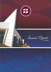 Federation University Historical Collection
Book, University of Ballarat Annual Report, 2009, 2009
Soft covered book with a building and details from an Aboriginal dot painting on the cover. Contents include: Univesity of Ballarat Charter, About the University, TravelSmart Program, Prospects Restaurant judged Best Training Restaurant in Victoria, IMB Services Centre opening, 'Learn to Succeed' branding, grant Street Foot Bridge,Manufacturing Technology Training Centre, riding for the Disabled, Equine Centre Images include: Grant Paulson, Robert H.T. Smith, David Battersby, Christine Nixon, Angela Carey, Andrew Allen, John Brumby, Jacinta Allan, Mathew Hall, Rowan Waina, Ronnie Smith, Alsion Nguyen, Grant Hackett, Frank Stagnitti, Sam Kameer, Rowena Coutts, Barbara Webb, Trevor Ferguson, Peter Gell, University of Ballarat Council .3) Financial Statementsuniversity of ballarat, battersby, webb, coutts, gell, annual report, david battersby, barabara webb, reconciliation action plan, grant paulson, robert h.t. smith, honorary doctorate - christine nixon, angela carey, andrew allen, geoff howard, dale boucher, frank stagnitti, rowena coutts, sovereign hill, jacinta allan -
 Southern Sherbrooke Historical Society Inc.
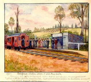
Photograph - 1906 railway accident, Belgrave
Watercolour painting by Charlie Hammond showing two train carriages at Belgrave Station. A group of people stand on the small platform beside the small station building which bears the sign 'Monbulk'. In the background are hilly paddocks. The most distant paddock has rows of what appear to be fruit trees. Below the painting Hammond has written '1901 Belgrave Station when it was Monbulk. Benson's Hill in the background. Later – Biffin's and later still – Harper's Guest House. Typical of all the stations along the line. Govt. had not recovered from the land boom and could not afford to build better ones.' This painting is based on a photo taken by Hammond in 1906, which is labelled by him, 'Sunday 28th Jany 1906. bringing the injured passengers to Belgrave Ry Station after the accident at the trestle bridge.' -
 Ballarat Tramway Museum
Slide - 27 mm sq slide/s - set of 7, Lilian Butler, Mt Pleasant line, Sep. 1971
Yields information about the streetscapes of Stones Corner to Mt Pleasant route and in particular buildings and people that crewed the trams.Set of seven Colour 27 x 27 mm slide in a Kodachrome cardboard mount. .1 - Tram turning onto the Mt Pleasant line at Stones Corner - Bridge St, Main Road .2 - Main Road looking south with Inland Body Works building on the left and Ampol Service Station .3 - Mt Pleasant terminus with the butcher shop on the left and the diary on the right - shows the terminating tram track .4 - Conductor changing pole. .5 - Putting pole on the overhead .6 - Conductor (D O'Leary - No. 38) standing in front of tram and Motorman or driver (N. Hall - No. 43) .7 - ditto with number visible. See Reg item 3425 for crew lists. Slide mount date September 1971. Photo from the collection of Lilian Butler.ballarat, tramways, trams, stones corner, main road, mt pleasant, crews, drivers, conductors, trolley poles, tram 41 -
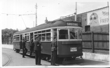
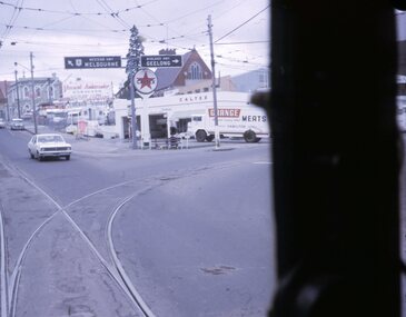
 Ballarat Tramway Museum
Slide - 35mm slide/s, Ben Parle, 5/04/1958 12:00:00 AM
Kodachrome Transparency - 35mm slide - cardboard mount, with one side with red border and words "Kodachrome Transparency / Processed by Kodak" top and bottom. Photo taken by Ben Parle 5/4/1958. Has slide No. "13" stamped in red in top corner. Photo of the No. 21 and 41in the Sturt St. City Loop, with a number of SEC crewmen standing in the shadows, while on the AETA tour. No. 21 has destination of Special. Both trams are carrying the AETA special car auxiliary signs. Trams have been reversed in the loop, and possibly to run "bang road" to Bridge St. Has the Odeon theatre in the background, advertisements for Robur Tea, Davies Bread. Note the Pie / Pasties sign on the building behind 21. For high resolution scan see btm2847h.tif"City Loop" "-5-4-58"tramways, trams, sturt st, city loop, tram 21, tram 41 -
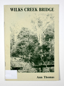 Marysville & District Historical Society
Book, Wilks Creek Bridge, 1993
A history of the Wilks Creek Bridge and its connection to the Yarra TrackPaperback. Front cover has an old photograph of the Wilks Creek Bridge.Dear Reader, The pen has only to select one of the many stages of building old Yarra Track,/ for a colorful story subject. The Track, first established in the early 1860's to/ serve goldseekers making their hazardous way to the rich Wood's Point goldfields,/ extended some 160km from Eltham - in Melbourne's northern region to Woods/ Point in the eastern ranges. I hope a glimmer of the excitement of those times comes through as I draw/ your attention to old Wilks Creek bridge and its picnic spot to be found 3.5km/ west of Marysville. Once part of Yarra Track and now superseded by a modern/ roadway alongside, the old bridge with its solid masonry walls either side of the/ cold, pure stream makes a pleasing scene for the visitor. With much pleasure/ I dedicate this narrative to Marysville and District Historical Society./ Ann Thomas Stamp of Marysville & District / Historical Society Inc / P.O. Box 22 / Marysville 3779wilks creek, marysville, yarra track, victoria, history, local history -
 Eltham District Historical Society Inc
Photograph, Roll of Honour Board, Eltham War Memorial, 2005
This 1954 Roll of Honour board was an action of the WW2 Eltham War memorial Trust, for hanging in their Child Welfare Centre building on their property in Main Road, Eltham. The Johnstons Furniture Production Company made up the board and had the names of the local Eltham enlistees applied in gold lettering at a total cost of £13.10.00. The names were copied by the Eltham RSL from the obelisk which was first erected by the WW1 Eltham Peace Celebrations in August 1919 at the northwest corner of Bridge Street and Main Road. During road widening plans by the Council, the obelisk was moved to the garden area of the refurbished RSL branch building in Main Road for safekeeping. The Honour Roll Board was sent to the Eltham RSL sub-branch around 1999. Following the merger of the Eltham and Montmorency sub-branches and sale of the Eltham property, the obelisk was relocated to a location in front of the Eltham War Memorial. The Honour Roll Board was retrieved by former Eltham District Historical Society President, Harry Gilham in September 2004 who arranged for it to be hung in the Eltham War Memorial Hall (former Children's Library). It is attached to the brick wall face of the west (rear) wall of the Hall.Colour photo print and 18 photocopied and hand written mixed media pages1953, briar hill timber, cr. e.j. andrew, eltham rsl sub-branch, eltham war memorial, eltham war memorial hall, eltham war memorial trust, ernie andrew, harry gilham collection, honour roll, johnstons furniture production company, johnstons furniture productions, meeting minutes, minute book, montmorency-eltham rsl sub-branch, nillumbik shire council, roll of honour, stanley s addison collection, stanley simpson addison -
 Federation University Art Collection
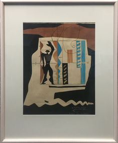
Work on paper - Printmaking - Lithograph (Limited Edition), Le Corbusier, 'Modulor' by Le Corbusier, 1956, 1956
Le Corbusier (or Charles-Édouard Jeanneret-Gris) (6 October 6, 1887 – August 27, 1965) Born Chaux-de-Fonds, Switzerland Studied at the local art school Began to study architecture in 1905 With Amedee Ozenfant founded the journal “L’Esprit Nouveau” in 1920 Became a French citizen in 1930 La Corbusier was a Swiss-French architect, designer, painter, urban planner, writer, and one of the pioneers of what is now called modern architecture. He was born in Switzerland and became a French citizen in 1930. His career spanned five decades, with his buildings constructed throughout Europe, India, and the Americas. (Wikipedia) The Modulor is an anthropometric scale of proportions devised by the Swiss-born French architect Le Corbusier (1887–1965). It was developed as a visual bridge between two incompatible scales, the imperial and the metric system. It is based on the height of a man with his arm raised. It was used as a system to set out a number of Le Corbusier's buildings and was later codified into two books. (wikipedia) This item is part of the Federation University Art Collection. The Art Collection features over 1000 works and was listed as a 'Ballarat Treasure' in 2007.Limited edition lithograph after an original collage by Le Corbusier, probably executed in Mourlot Workshop. art, artwork, le corbusier, modular, mourlot workshop, lithograph, colour lithograph, printmaking, aavailable -
 Eltham District Historical Society Inc
Negative - Photograph, The Bridge, Hurstbridge, Vic, c.1925
Copied from brochure "Wattle Valley Estate" 7 minutes from the bridge. The new bridge designed by Sir John Monash over the Diamond Creek near Hurst's home of 'Mia Mia' at Hurstbridge. The Wattle Valley Estate was first advertised in August 1925 as weekend building allotments by the Greater Melbourne Land and Development Company. Advertised from £28.10.0 or £60 per block. In August 1926, 30 picked allotments of 60x150 feet were put up for auction Saturday August 14, 1926 with frontages to Valley View Road and Fawkner Crescent advertised in the “Heart of the Glorious Wattle Country” and “Within 15 Minutes of the Newly Electrified Railway Station”. The Advertiser on August 13, 1926 in an article promoting the auction stated “the estate is regarded as one of the best in the district, and will be sold practically without reserve.” It is noted that an advertisement running in The Argus February 22, 1951 offered the remaining 16 blocks for sale at £12.10.0 or £200 the lot. By March 7, the remaining blocks were advertised at £17.10.0 The Wattle Valley Estate took over 20 years to sell and then people could not build on them This image was also used in a brochure advertising the "Wattle Valley Estate", which forms part of the Shire of Eltham Pioneers Photograph Collection (Cross Reference Photo No.(s): 1056, 1057)This photo forms part of a collection of photographs gathered by the Shire of Eltham for their centenary project book,"Pioneers and Painters: 100 years of the Shire of Eltham" by Alan Marshall (1971). The collection of over 500 images is held in partnership between Eltham District Historical Society and Yarra Plenty Regional Library (Eltham Library) and is now formally known as the 'The Shire of Eltham Pioneers Photograph Collection.' It is significant in being the first community sourced collection representing the places and people of the Shire's first one hundred years.Digital image 4 x 5 inch B&W Negshire of eltham pioneers photograph collection, hurstbridge, bridge, diamond creek (creek), monash bridge, wattle valley estate