Showing 700 items matching "four corners"
-
 Bendigo Historical Society Inc.
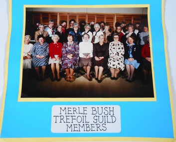
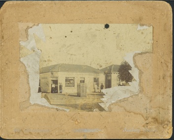
Photograph - Photographs of members
The Merle Bush Trefoil Guild was registered in Bendigo on 18/06/1981.The decision to disband the Merle Bush Trefoil Guild was made at a General Meeting on 17/02/2016. The group agreed to continue as the Merle Bush Friendship Group. The Australian Trefoil Guilds connect women who are either actively involved in Girl Guiding or have a history with Girl Guiding. The purpose of a Trefoil Guild is to keep alive the spirit of the Promise and Law, carry this spirit into the community and to give support Guiding.Three coloured photographs of members of the Merle Bush Trefoil Guild. Taken in May 1986. 6942.9a. Coloured photograph of a group of women in three rows with front row seated. Timber folding doors in the background. Many of the back row are obscured. The photograph is mounted on layers of blue and yellow card. List of names handwritten on the back. BACK - Mabel Cooper, Lola Johnson, Nell Cooper, Wynne Palmer (Baker), Treasurer Hoskin, Rita Allen, Kitty Rose, Joyce Corner, Jean Theodore, Sylvia Thompson, Anne Butler, Lola Dickson, Nell Love, Betty Nicholls, Vi Pemberthy, Audrey McKenzie, Beryl Turner. FRONT - Lil Nielson, Betty Runnalls, Gladys Penow, Marie Norris, Berry Wallace, Melva Mason, Norma Young, Bette McLaughlin, Margaret Baker. Label pasted under photograph "Merle Bush Trefoil Guild Members". 6942.9b Coloured photograph of a group of women in three rows with front row seated. Timber folding doors in the background. Many of the back row are obscured. The photograph is mounted on layers of blue and yellow card. List of names handwritten on the back. BACK - Lil Nielson, Nell Cooper, Wynne Baker, Mabel Cooper, Jean Theodore, Rita Allen, ? , Gladys Penow, ? ,Treasure Hoskin, ? , ? , ? , ? , Melva Mason, Audrey McKenzie, Sylvia Thompson, Anne Butler, Lola Dickson, Betty Nicholls, Joyce Corner, Beryl Turner ?, Nell Love, ? , Vi Pemberthy. FRONT - Betty Runnalls, Lola Johnson, Marie Norris, Bev Wild, Berry Wallace, Irene Kerry, Jean Goodrich, Norma Young, Label pasted under photograph "Merle Bush Trefoil Guild Members". 6942.9c Coloured photograph of four women. The photograph is mounted on layers of blue and yellow card. List of names handwritten on the back. Marie Norris, Berry Wallace, Wynne Baker, Melva Mason. Merle Bush Trefoil Guild 1986. Merle Bush Trefoil Guild Collection.girl guides, guiding, merle bush, trefoil guild -
 Bendigo Historical Society Inc.
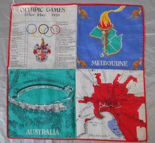
Textile - 1956 Olympics Ladies' handkerchief
The 1956 Summer Olympics, officially known as the Games of the XVI Olympiad, were an international multi-sport event held in Melbourne, Victoria, Australia, from 22 November to 8 December 1956, with the exception of the equestrian events, which were held in Stockholm, Sweden, in June 1956. These Games were the first to be staged in the Southern Hemisphere and Oceania, as well as the first to be held outside Europe and North America. Handkerchief produced as a souvenir for the 1956 Melbourne Olympics. Synthetic fabric. The handkerchief s bordered in red thread and divided into four squares of contrasting colours. 1. A table of main events and ceremonies, Olympic rings and symbol. 2. Map of Australia (green) with an Olympic torch and kangaroos in each corner. 3 An image of the main stadium. caption "AUSTRALIA" in white on a green background. 4. Map of Melbourne in red with connecting road and rail links to other parts of Victoria. 1956 olympics, handkerchief -
 Bendigo Historical Society Inc.
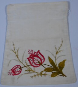
Domestic object - Lingerie Garment Bags
Donor believes items were completed by her great aunts Lydia, Rosa, Olivia and Isabelle Pollard when the sisters were young girls. They were completed in Country Durham, England. The items have been passed down through the family by the girls mother or aunt.Two handmade embroidered laundry bags. 6575.1 Red flowers with green leaves and white foliage embroidered on a cream cotton front, back of bag is undecorated. Hand and machine stitching evident. 6575.2 Gold flowers, green leaves and some white foliage. Four rings attached with gold and cream stitching on top of bag for hanging.A L 4 embroidered in top left hand corner of 6575.1 in yellow thread. A L embroidered at top L H corner of 6575.2 in red thread.late victorian needlework, handmade embroidery, lingerie bag, garment bags, cleary -
 Bendigo Historical Society Inc.
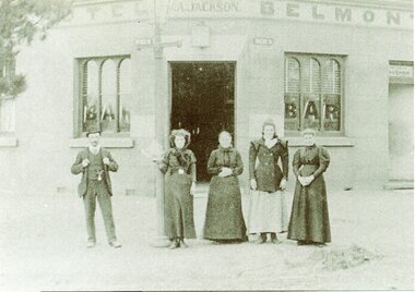
Photograph - BENDIGO HOTEL COLLECTION: BELMONT HOTEL CORNER NEALE AND SKENE STREETS
Sepia coloured photograph of four women and a man standing in front of the Belmont hotel. Two photos one an enlarged copy of the other. The licensee was Ann Jackson wife of Edward Jackson who was blinded in an underground explosion at the Lady Barkly mine in 1875. Their daughter Ann Jackson continued in the hotel until the 1950's.bendigo, hotel, belmont hotel -
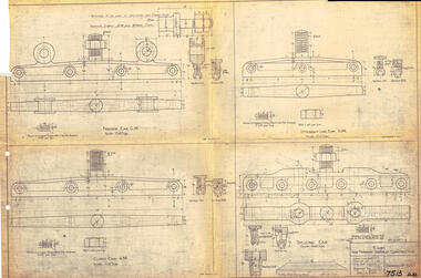 Ballarat Tramway Museum
Drawing, Victorian Railways (VR), Ears for Tramway Overhead Construction, 1924
Gives the design details of the device or fitting known as a trolley wire ears that holds a tramway copper trolley wire in position. Notes that the drawing was traced in 1924 from a MMTB drawing. Has details for a splicing ear, straight line ear. feeder ear and curve ear along with details for nuts and screws.Yields information about the design of four different types of trolley wire fittings and how they were fabricated for use on the two tram lines, or electric street railways operated by the Victorian Railways.Dyeline print of Victorian Railways drawing number 4057 - Ears for Tramway Overhead ConstructionHas number "7513 D.33" in black pen in bottom right hand corner.tramways, trams, overhead, victorian railways, trolley wire, engineering, electrical engineering -
 Ballarat Tramway Museum
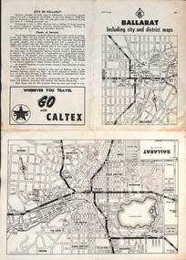
Map, RACV - Royal Automobile Club of Victoria, "Ballarat including city and district maps", 10/1961
Shows the central part of Ballarat, Ballarat Outlets, streets, principal attractions, Ballarat and district maps and information. Has the tram lines shown dotted, does not run out to Sebastopol or the Lydiard St North terminus. Each map in the bottom left-hand corner has the number "1061", possibly indicating the date. Has notes on the City, points of interest, and an advertisement for Caltex. See item 4929 for a larger version dated 1966. Yields information about the extent of Ballarat in the early 1960's shows the tram lines and other rail lines in the district. Four fold map printed on white paper, titled "Ballarat including city and district maps" - Map No. MAP 15.314 and dated 10-61. Produced by the RACVmap, tranways, ballarat, racv, railways -
 Ballarat Tramway Museum
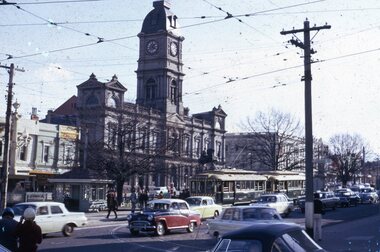
Slide - Set of six slides Ballarat City area, September 1971
Set of six colour slides, possibly taken on Saturday 4 September 1972, prior to the closure of the Mt Pleasant line the following day. 1 - Two single truckers at Sturt and Lydiard Streets with many motor cars. Town Hall in the background. 2 - Tram 12 (Sebastopol) picking up passengers at the stop just before the tram turned the corner into Sturt St. Driver running a one-man tram. In the background are the ANZ and other bank buildings. 3 - Tram 13 at Stones Corner - with the destination of Gardens via Sturt St. West. The tram is crowded. 4 - Grenville and Sturt St with four trams and many motor cars - taken from near Lydiard St. 5 - Single trucker descends the hill to Grenville St, with the Titanic Bandstand in the background, 6 - Bogie tram westbound in a very busy Bridge St, near Grenville St. Demonstrates tram operations in the Ballarat city area prior to closure of the SEC operated system.Set of six Kodachrome cardboard slides.tramways, ballarat, trams, tram 12, city, lydiard st north, tram13, stones corner, sturt st, bridge st -
 Ballarat Tramway Museum
Sign, State Electricity Commission of Victoria (SECV), "CARS TAKE FOLLOWING LINE"
Galvanised sheet steel with top & bottom holes(central) & side mounting brackets & rounded corners. Painted with black base and white letters and lines used to indicate which depot track(Line) trams were to be parked or stabled on when returning to the depot. Depot had four under cover tracks (1 to 4) and one outside track ("0") road. Lettered as shown on the sketch on the original worksheet. Reg. Item No. 1170.1? shows the object in a wooden frame mounted onto a pole opposite the depot, by depot junction point.trams, tramways, depot, secv, ballarat, tramcar operations, operations -
 Ballarat Tramway Museum
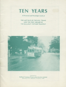
Book, Ballarat Tramway Preservation Society (BTPS), "Ten Years", Sep. 1981
Yields information about the closure of the SEC operated Ballarat tramway system and the formation and first 10 years of the BTPS. Contains a number of cuttings, Hansard extracts and photographs.Book - 40 page + covers, book describing the last days of the SECV's Ballarat operation, the formation of the BTPS and the first 10 years of the BTPS operating. Cover-card with photos in green ink. Title = "Ten Years" Book has 40 photos, four drawings, list of SECV trams at Sept. 1971. 309.1 - donation by Neville Gower 309.2 - collected from stock.309.1 - has "Neville Gower" in ink on page 3, top right hand corner.trams, tramways, ballarat, secv, btps, closure -
 Kew Historical Society Inc
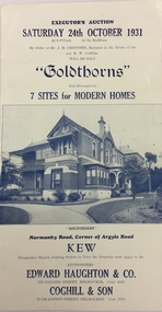
Document, Executor's Auction, Sunday 24th October 1931, "Goldthorns", Normanby Road, Corner of Argyle Road, Kew, 1931
Rare real estate brochure relating to the sale of a historically significant Kew mansion. The rarity the document is increased due to the photographs of the front of the house and of the extensive rear garden.Four page flyer advertising the sale of Goldthorns in Normanby Road, Kew in October 1931. The flyer contains a photograph of the front of the house, a list of its rooms, a site plan (including possible subdivisions). and a photo of the rear garden.goldthorns - normanby road, kew (vic), real estate - kew (vic), griffith family - kew (vic), gardens - kew (vic), subdivisions - kew (vic) -
Kew Historical Society Inc
Archive (Sub-series) - Subject File, Kew Historical Society, 'Goldthorns' (Houses, Kew), 1958
Various partiesReference, Research, InformationSecondary Values (KHS Imposed Order)Subject file containing Executor's Auction, Sunday 24th October 1931, "Goldthorns", Normanby Road, Corner of Argyle Road, Kew’ - Four page flyer advertising the sale of Goldthorns in Normanby Road, Kew in October 1931. The flyer contains a photograph of the front of the house, a list of its rooms, a site plan (including possible subdivisions) and a photo of the extensive rear garden.goldthorns - normanby road - kew (vic),, goldthorns estate, mansion - kew (vic), gardens - kew (vic), griffiths family, subdivisions - kew (vic)goldthorns - normanby road - kew (vic),, goldthorns estate, mansion - kew (vic), gardens - kew (vic), griffiths family, subdivisions - kew (vic) -
 Kew Historical Society Inc
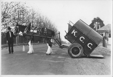
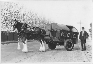
Photograph - City of Kew Horse, Cart and Employee, c.1950
The City of Kew was a suburb in Melbourne from 1860 to 1994.One of four original black and white photographs by Stuart Tompkins Camberwell of a horse and cart and a council employee, Barry Avery, in Parkhill Road, Kew. In a number of photos the cart has K.C.C., in large letters on its side. It is presumed to be the city garbage cart No.3 which was stationed at the old Council Depot on the corner of High and Disraeli Streets."Location Cr Parkhill Rd & Hillcrest Av KEW / Driver Barry Avery"city of kew, garbage waste collection - kew (vic), barry avery, kew depot, stuart tompkins -
 Kew Historical Society Inc
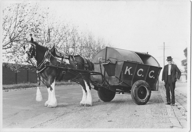
Photograph - City of Kew Horse, Cart and Employee, Stuart Tompkins, c.1950
The Kew City Council Depot was for a period situated on the corner of High Street and Disraeli Streets. The photo from the former City of Kew Municipal Collection was taken by a photographer from Stuart Tompkins Studio in Camberwell.One of four black and white photographs (perhaps reproductions) of a horse and cart and a council employee in Parkhill Road, Kew. In a number of photos the cart has K.C.C., in large letters on its side. It is presumed to be the city garbage cart No.3 which was stationed at the old Council Depot on the corner of High and Disraeli Streets. "Cr Parkhill Rd & Hillcrest Ave Kew / Driver : Barry Avery"city of kew, garbage waste collection - kew (vic), barry avery, kew depot, stuart tompkins -
 Kew Historical Society Inc
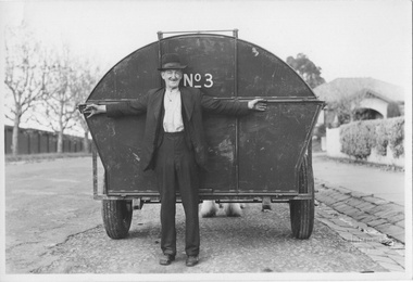
Photograph - City of Kew Horse, Cart and Employee, Stuart Tompkins, c.1950
The Kew City Council Depot was for a period situated on the corner of High Street and Disraeli Streets. The photo from the former City of Kew Municipal Collection was taken by a photographer from Stuart Tompkins Studio in Camberwell. One of four original black and white photographs by Stuart Tompkins Camberwell of a horse and cart and a council employee, Barry Avery, in Parkhill Road, Kew. In a number of photos the cart has K.C.C., in large letters on its side. It is presumed to be the city garbage cart No.3 which was stationed at the old Council Depot on the corner of High and Disraeli Streets. "Cr Parkhill Rd & Hillcrast Ave Kew / Driver Barry Avery"city of kew, garbage waste collection - kew (vic), barry avery, kew depot, stuart tompkins -
 Kew Historical Society Inc
Photograph - City of Kew Horse, Cart and Employee, Stuart Tompkins, c.1950
The Kew City Council Depot was for a period situated on the corner of High Street and Disraeli Streets. The photo from the former City of Kew Municipal Collection was taken by a photographer from Stuart Tompkins Studio in Camberwell. One of four original black and white photographs of a horse and cart and a council employee, Barry Avery, in Parkhill Road, Kew. In a number of photos the cart has K.C.C., in large letters on its side. It is presumed to be the city garbage cart No.3 which was stationed at the old Council Depot on the corner of High and Disraeli Streets. "Cr Parkhill Rd & Hillcrest Ave, Kew / Driver: Barry Avery"city of kew, garbage waste collection - kew (vic), stuart tompkins, barry avery -
 Tennis Australia
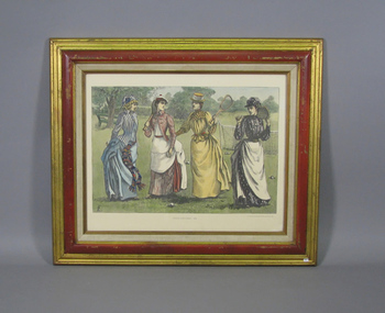
Print, 1888
Colour lithograph reproduction with caption 'TENNIS COSTUMES -1888'. Depicts four women with in tennis attire, three with racquets. A tennis net is visible behind them. Artist's initials 'LFE' in bottom left corner. Materials: Ink, Wood, Paper, Glass, Metaltennis -
 Kew Historical Society Inc
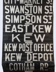
Functional object - Destination Roll, Melbourne & Metropolitan Tramways Board, 1960s
In an era predating the computerisation of equipment on public transport, where trams in Melbourne were driven by drivers and conductors sold fares, destinations were shown at the front and rear of the tram within a glazed box. A driver adjusted the roll to select each new trip destination. Given the length of rolls, in this case approximately nine metres, this could be a time consuming process. In addition to the named destination roll, each tram included a separate roll listing the route numbers.The roll was purchased at a Leski Auction in Armadale as part of a large group of tramways memorabilia including tram 'rolls' from New South Wales, Victoria, South Australia and Tasmania. The auction house described the collection as "The collection of destination blinds or rolls that forms the core of the Railways Trams & Buses Section (Lots 655 – 732) is the best we have ever offered and represents a life-time of collecting by an Adelaide enthusiast, now deceased." Melbourne & Metropolitan Tramways Board Tramways Destination Roll. Black and white paint on linen roll. Forty-eight named destinations including four depots - Camberwell, Hanna Street, Hawthorn, Kew. Multiple destinations in what is now the City of Boroondara (Kew, Hawthorn and Camberwell); including East Kew, Kew, Kew Post Office, Kew Depot, and Cotham Road.Named destinations beginning to end: “Olympic Park / Special / Football / Racecourse / Richmond / Burnley / Riversdale / Wattle Park - Warragul Rd / Wattle Park - Elgar Rd / City / Burwood / Hartwell / Bowen St / Camberwell Depot / Camberwell Jucn / Leura Grove / Gardener / Glenferrie Rd / Chapel St / St Kilda Rd / Camberwell / City / Lonsdale St / University / City via William St / Domain Rd / Hanna St Depot / South Melb & St Kilda Beach / Prahran / North Richmond / Windsor / Hawthorn Depot / Hawthorn / Spencer St / Toorak Rd / Swan & Church St Cnr / North Balwyn / City Flinders & Spencer Sts Corner / City - Market St / Swanston St / Simpson St / East Kew / Kew / Kew Post Office / Kew Depot / Cotham Rd / Malv Tn Hall"melbourne & metropolitan tramways board -
 Kew Historical Society Inc
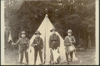
Photograph - Scouts in front of Bell Tent
The 1st Kew Scouts was one of the first Scout Troops in Victoria, being formed in 1909. From 1927 they met in a magnificent Scout Hall in Disraeli Street, Kew until it was demolished in 1993. Still operating (in 2020) from their new Scout Hall on the corner of Kilby Road and Kellett Grove, Kew.Print copy of a photograph showing four members of the 1st Kew Scouts in front of a Bell Tent. C.E. Holmes is the scout holding the flag at left.boys scouts, scouting awards, 1st kew scouts, c e holmes -
 Kew Historical Society Inc
Photograph - Royal Hotel, Sunbury, C.H.R. Christianson, 1890s
This item is part of a larger collection donated to the Kew Historical Society by Anna French. The collection includes personal items from the donor's family, as well as items given to the donor and her mother by a family friend, Lucy Merritt (Jean) Hornby. The item is from that part of the collection inherited or assembled by Jean Hornby. The collection is significant given Jean Hornby's mother's descent from Robert Hornby (1854-1935) and Eva Merritt (1865-1959); her mother the chid of a family who settled in Kew in the 1850s, this providing a chain of provenance for items dating to the mid-nineteenth century, when her maternal forebears arrived in Melbourne. Other items represent Jean Hornby's contribution to her local and wider community.This 19th century photograph includes significant architectural details of an important hotel in Sunbury, Victoria. Additionally, it was taken by a local photographer - CHR Christianson - who operated the Sunbury [photographic] Studio. Silver albumen print, mounted on board, of the original Royal Hotel on the corner of Brook and Evans Streets, Sunbury, Victoria.The single-storey, rendered brick building with a corrugated galvanised iron roof includes a number of pieces of information that may assist in dating the photograph. The licensee's name above the door appears to be M.A. Williams. To the left of the door on the external wall is a painted sign: 'BILLIARDS". Another painted sign on the front of the building reads "ROYAL HOTEL [illegible] BILLIARDS." An attached building at right may be the residence of the licensee. Specific architectural features of the building include a corner doorway with a lamp above, three sash windows and a larger square lead-light window to the right of the doorway. The latter identifies the space behind as the "BAR". On the footpath in front of this building is a grill set into the footpath to enable deliveries to a cellar. At least four figures can be identified in the photograph: a woman in the doorway, a man to her right, leaning against the wall, and two other men at the right hand side of the building. Beyond the boundary of the building is a sloping footpath to a bluestone edged gutter. An elm [sic] within a protective, picketed surround is in front of the building. C.H.R. Christianson is identified on the reverse as the photographer. Reverse in pencil: Royal Hotel Billards Sunbury / CHR Christianson photographerroyal hotel -- sunbury (vic.), chr christianson -- photographer, hotels -- sunbury (vic.), recreation -- billiards -
 Kew Historical Society Inc
Photograph - 'Fernhurst', 13 Fernhurst Grove, 1978
George Wharton arrived in Melbourne in 1844. An architect and surveyor, he was appointed to lay out the 'Village of Kew' by N.A. Fenwick following the land sales of 1851. A protagonist for Kew's separation from the Boroondara District Road Board, he was elected chairman when Kew achieved municipal status in December 1860. His home, 'Fernhurst', was built in 1866 on eight acres in Studley Park, with a four-storey tower and pyramidal roof. The Italianate home was a prominent Kew landmark. It was demolished in 1979 and replaced by St Paul's College in 1980.Rare colour photograph of what was once a significant mansion in Kew.Original colour positive photograph (Kodak print) of 'Fernhurst' in 1978. Photographed by Stewart West in May 1978, one year before it was demolished, the photograph gives little idea of the large landholding once surrounding the house. Originally accessed from near the corner of Princess Street and Studley Park Road, its gardens had been subdivided in the 1900s and its footprint restricted to 13 Fernhurst Grove. Like many other grand houses, by the 1970s it had been converted into apartments. From the photograph, one can see that the house had retained many of its original features such as the distinctive tower and the wide bow-fronted verandah. The slates on the roof (apart from those on the tower) had been replaced by tiles and the cement render of the exterior painted white. Annotated reverse: "Fernhurst corner shot through trees / 12-22"fernhurst, 13 fernhurst grove -- kew (vic.), george wharton, italianate architecture, vila maria society, st paul's school for the blind -
Kew Historical Society Inc
Archive (series) - Subject File, 'Bella Vista', (aka 'Malinda')
Kew Historical SocietySince its foundation in 1958, members of the Kew Historical Society have been compiling and storing information about subjects relating to the history of Kew and its environs, of which this file is an example.Secondary values'Bella Vista' was a large Federation house built in 1902 which occupied the eastern corner of Thomas Street and Cotham Road. The house was built for Abel Hoadley who died in 1918. In 1937 Augustus Beker opened the property as a guest house named 'Malinda' Guest House. This closed in 1940. In 1941, the land was subdivided into four lots. During the 1940s, Fr. Maas opened a hostel for Dutch Catholic immigrants in the house. The house has now been demolished. The subject file contains an auction notice for the sale of Malinda in 1941 along with correspondence from 2016 detailing background information, a timeline of the demolition of th those, the name of the original owner, and other uses of the house's name.malinda, bella vista, cotham road, fr maas, abel hoadley, anthony heinemannmalinda, bella vista, cotham road, fr maas, abel hoadley, anthony heinemann -
 Kew Historical Society Inc
Plan - Subdivision Plan, Maxwelton, Kew, 1920-1940
Pru Sanderson, in her groundbreaking ‘City of Kew Urban Conservation Study : Volume 2 - Development History’ (1988), summarised the periods of urban development and subdivisions of land in Kew. The periods that she identified included 1845-1880, 1880-1893, 1893-1921, 1921-1933, 1933-1943, and Post-War Development. These periods were selected as they represented periods of rapid growth or decline in urban development. An obvious starting point for Sanderson’s groupings involved population growth and the associated economic cycles. These cycles also highlighted urban expansion onto land that was predominantly rural, although in other cases it represented the decline and breakup of large estates. A number of the plans in the Kew Historical Society’s collection can also be found in other collections, such as those of the State Library of Victoria and the Boroondara Library Service. A number are however unique to the collection.The Kew Historical Society collection includes almost 100 subdivision plans pertaining to suburbs of the City of Melbourne. Most of these are of Kew, Kew East or Studley Park, although a smaller number are plans of Camberwell, Deepdene, Balwyn and Hawthorn. It is believed that the majority of the plans were gifted to the Society by persons connected with the real estate firm - J. R. Mathers and McMillan, 136 Cotham Road, Kew. The Plans in the collection are rarely in pristine form, being working plans on which the agent would write notes and record lots sold and the prices of these. The subdivision plans are historically significant examples of the growth of urban Melbourne from the beginning of the 20th Century up until the 1980s. A number of the plans are double-sided and often include a photograph on the reverse. A number of the latter are by noted photographers such as J.E. Barnes.The subdivision, ‘Maxwelton’, included four lots in East Kew, at the northwest corner of Burke Road and Cotham Road. Lot 3 is identified as the location of an existing house. The site of the subdivision equates to that parcel of land where a contemporary block of three storey apartments at 1245 Burke Road is now located.subdivision plans - kew, mazwelton subdivision, burke road -- kew (vic.), cotham road -- kew (vic.) -
 Kew Historical Society Inc
Postcard, Victoria Street Bridge, Collingwood, 1905-1913
Victoria Bridge is a riveted and welded steel Warren truss bridge over the Yarra River completed in 1884 to a design by Fraser & Chase following a controversial design competition held in 1880. Funds for the bridge's construction were provided by the councils of Collingwood, Hawthorn, Kew and Richmond. The contract was awarded to Mr P. Platt. Charles Rowand was officially appointed Supervising Engineer in 1883. The winning design was based on the theoretical work of William Charles Kernot (1845-1909) who campaigned for economy in public works design and the application of scientific principles in engineering. ... The bridge was widened in 1890 by the addition of a third line of truss on new piers on the up stream side to carry horse trams. Work commenced in 1914 to convert the horse tramway to an electric tramway by the Prahran & Malvern Tramways Trust, part of the Trust's extension of its tramway into the eastern suburbs between 1913-18. In 1915 the bridge was further strengthened to accommodate the extra weight of electric trams and widened by the addition of two six feet cantilever footpaths. During this period the Prahran & Malvern Tramways Trust erected two ornamental gantries over the roadway to support overhead wires for the electric tramway. Further widening and reconditioning of the bridge took place in 1933, including the addition of four new welded trusses, two intermediate and two on the outside. The latter were supported on new cantilevered truss cross beams attached to the top of the piers. (Source: Heritage Victoria)Early and rare postcard of the Victoria Street Bridge linking Victoria Street and Barkers Road.Polychrome postcard of the Victoria Street Bridge which links Richmond and Abbotsford with Kew and Hawthorn.View from Harrison Cres embankment / former Xavier College boatshed on site of tree in foreground. / Chimney left corner - Wool Scoring Mils in Victoria St. / On horizon - Studley Villa, Studley House circa 1880s, Studley Hall / Chinese gardens to be seen behind three set of columns / M.J. Slatterypostcards -- yarra river, postcards -- bridges. -- greater melbourne (vic.), victoria street bridge -
 Kew Historical Society Inc
Plan, Melbourne and Metropolitan Board of Works, Melbourne & Metropolitan Board of Works : Borough of Kew : Detail Plan No.1294 & 1295, 1904
The Melbourne and Metropolitan Board of Works (MMBW) plans were produced from the 1890s to the 1950s. They were crucial to the design and development of Melbourne's sewerage and drainage system. The plans, at a scale of 40 feet to 1 inch (1:480), provide a detailed historical record of Melbourne streetscapes and environmental features. Each plan covers one or two street blocks (roughly six streets), showing details of buildings, including garden layouts and ownership boundaries, and features such as laneways, drains, bridges, parks, municipal boundaries and other prominent landmarks as they existed at the time each plan was produced. (Source: State Library of Victoria). This plan forms part of a large group of MMBW plans and maps that was donated to the Society by the Mr Poulter, City Engineer of the City of Kew in 1989. Within this collection, thirty-five hand-coloured plans, backed with linen, are of statewide significance as they include annotations that provide details of construction materials used in buildings in the first decade of the 20th century as well as additional information about land ownership and usage. The copies in the Public Record Office Victoria and the State Library of Victoria are monochrome versions which do not denote building materials so that the maps in this collection are invaluable and unique tools for researchers and heritage consultants. A number of the plans are not held in the collection of the State Library of Victoria so they have the additional attribute of rarity.Original survey plan, issued by the MMBW to a contractor with responsibility for constructing sewers in the area identified on the plan within the Borough of Kew. The plan was at some stage hand-coloured, possibly by the contractor, but more likely by officers working in the Engineering Department of the Borough and later Town, then City of Kew. The hand-coloured sections of buildings on the plan were used to denote masonry or brick constructions (pink), weatherboard constructions (yellow), and public buildings (grey).The streets and built structures in MMBW Detail Plan 1294 & 1295 were surveyed in 1903 and released to contractors in 1904. This plan is one of two in the collection where the lithographers amalgamated two separate plans. Both plans include sections of Studley Park. Dominating the south and west corners of Kew Junction are the Clifton and Kew Hotels. The Kew Hotel, owned by Patrick O’Shaughnessy was one of the oldest in Kew. MMBW plans were amended over time to take account of new subdivisions such as that which created Merrion Place. Of the four mansions shown in Studley Park Road, three remain – ‘Field Place’, the home of Frances Henty, ‘Leaghur’ and ‘Darley’. ‘Byram’ (later ‘Goathland’, then ‘Tara Hall’) was an architectural marvel. Designed in 1888 by E.G. Kilburn for the paper magnate George Ramsden, it was demolished in 1960. While an earlier sale of the southern section of Byram had created Tara Avenue in 1927, the demolition of the house in 1960 enabled the extension of Tara Avenue northward.melbourne and metropolitan board of works, detail plans, mmbw 1294, mmbw 1295, cartography -
![Section of mural from the ballroom of 'Ordsall' [Southesk], Cotham Road](/media/collectors/550653872162f11fb04854aa/items/5729628d2162f108e8d6d03f/item-media/614c29204739c077d925d5a8/item-fit-380x285.jpg) Kew Historical Society Inc
Kew Historical Society IncPainting - Section of mural from the ballroom of 'Ordsall' [Southesk], Cotham Road, Cullis Hill & Co, 1882
Ordsall, renamed Southesk in the 20th century was built for John Halfey in or before 1865. The house was rebuilt in the 1870s to designs by architect Michael Hennessy. In 1882 the house was redecorated by the firm of Culls Hill & Co., who hired the artists 'Mr Vandenbrandt' and 'Signor Rizzi" to paint the ceilings of the ballroom and the drawingroom. The artistic triumph was described in detail in The Argus, 30 October, 1882. In 1947, Southesk was purchased by the Kew City Council. For 23 years it was used as a meeting place for community groups. The house was then demolished in 1970 to make way for a new Town Hall.The interiors of the two main reception rooms at Ordsall included some of the most outstanding domestic frescos painted in Australia in the late Victorian period. These frescos were executed by artists hired by the firm of Cullis Hill & Co. While a number of photographs were taken of the interiors prior to the house's demolition in 1970, this small fragment of the fresco is one of only three extant. The fresco allows conservators to examine and evaluate fresco techniques of the period.One of only two fragments of the painted domed ceiling of the ballroom of Ordsall (later renamed Southesk) which once stood at the corner of Cotham Road and Charles Street, Kew. This roughly square piece of the plasterwork shows a woman's head. Given the size of the face, it is believed that this section of the fresco represents one of the four 'geographic depictions of the earth including the seasons, night and morning'.Label: 'This is from the Southesk Ballroom 14-7-70'cullis hill & co., fresco, ordsall, southesk -
 Kew Historical Society Inc
Photograph - Clifton Hotel, Kew Junction, 1994
Of the eight hotels established in Kew since European settlement, The Hotel Kew, known for most of its existence, as the Clifton Hotel was the seventh to be built in 1868. Its location on the corner of Studley Park Road and High Street at Kew Junction makes it a prominent landmark. Its current name is confusing for local historians as its main rival for the first 52 years was O'Shaughnessy's Hotel (1855), later renamed the Kew Hotel, on the corner of High Street and Denmark Street. Looking at the façade of the Hotel Kew, it is hard to imagine its mid-nineteenth appearance. There have probably been at least four renovations or rebuilding(s) of the structure. The documented renovations have occurred in the 1930s when the late Victorian façade was given an Art Deco update. In about 1970 its façade was again 'improved'. The many publicans who have held the licenses of the Clifton Hotel have been identified in in the 'Tetlow Index' and on the 'Boroondara Local History Wiki'. The most significant of these are Henry Madden (1880-87); Michael O'Donnell (1902-1920); and the Cronin-Ryan family (1935–53ff).Fading colour positive photograph of the Clifton Hotel at Kew Junction on the corner of High Street South and Studley Park Road. The hotel had been modified extensively over time, disguising the original Italianate facade. This is the colour scheme of the fourth restoration, including huge advertising billboards on the roof.Reverse: "Clifton Hotel. Studley Park Road at Kew Junction. 1994clifton hotel -- kew (vic.), hotels -- kew (vic.), kew junction -
 Friends of Westgarthtown
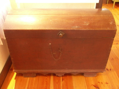
Trunk/ Koffer, c. 1840s
The chest was constructed to allowable dimensions for storage in the ship's hold. The sturdy watertight construction afforded protection for the chests contents. It can be imagined that these would be household utensils, items of clothing and the most treasured ornaments as space permitted. It is likely that the contents included some building tools and as well, implements which Christian Ziebell used in his trade as a butcher in Bruel, thereby enabling him to undertake profitable work on his arrival in Australia.This object is of primary significance. The Koffer was constructed to allowable dimensions for storage in the ship’s hold. The sturdy watertight construction afforded protection for the Koffer’s contents on the voyage aboard the Privislaw from Hamburg, Germany to Hobsons Bay, Australia in 1850. The Koffer held the precious necessities for life for Christian Ziebell's family at their new destination. It is likely that the contents included some building tools as well, implements that Christian used in his trade as a butcher in Bruel, thereby enabling him to undertake profitable work on arrival in Australia. The wooden Koffer was airtight, so if lost overboard it would be retrievable. Some were fixed to the ship’s deck. After they settled at Westgarthtown the Koffer continued to contain the precious documents through each generation. Only the current owners saw the contents in each generation, and the children always regarded it as a “treasure chest”, which was always locked and out of bounds for them. Large wooden trunk/koffer. Base is rectangular, and lid is rectancular to fit the base but curves between the front and back. Morticed corners; protruding base with beveled edge. Supported by profiled runners with four built-in feet. Handle for carrying on each end, and locking mechanism on front.'C. Ziebell' written in large font on back of chestpersonal effects, travel goods, pribislaw, johann christian ziebell, german migration, luggage -
 Friends of Westgarthtown
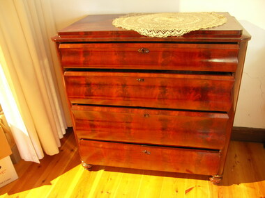
Chest of drawers
Large wooden chest of drawers, four drawers, on four feet. Front two turned, back two square. Lock in each drawer, front centre - screw on decorative keyhole surrounds. Drawers all of different sizes, rounded front corners.furniture, domestic, chest, drawer, timber, varnished -
 Friends of Westgarthtown
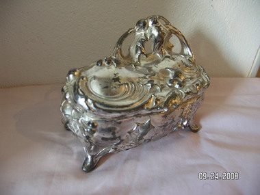
jewelery box
Jewelry box ornate casting with holly motif, handle formed by holly. Silver plated gun metal (?). Hinged lid, on four splayed feet, pink satin lining (top and bottom) with cord rim on bottom.J.B' on underside in one corner, '334' diagonally opposite corner.personal effects, containers, jewelry box, container, holly, ornate, metal -
 Glen Eira City Council History and Heritage Collection
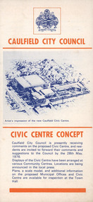
Pamphlet, "CAULFIELD CITY COUNCIL CIVIC CENTRE CONCEPT", c. 1976
Pamphlet commissioned by Council to promote and call for resident's comments on the Caulfield City Council's proposed Civic Centre by the 28th May 1976.Cream colour paper pamplet folded to create 4 panels with text and images printed in blue and orange ink on recto and verso of the four panels. The cover panel has "Caulfield City Council Civic Centre Concept" printed in orange with a blue copy of an artist's impression of the new Caulfield Centre and a blue representation of the City of Caulfield Coat of arms at the top. The other seven panels have been individually numbered from 1 to 7 however panels 1&2, 3&4 and 5&6 have been designed to be viewed together.