Showing 3447 items
matching road bridges
-
 St Kilda Historical Society
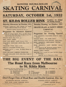
Ephemera - Poster, Monster Double-Roller Skating Carnival, 1932
... and Road Race from Princes Bridge to the rink.... Carnival, Adults Carnival and Road Race from Princes Bridge ...Poster advertising a skating carnival at St Kilda Roller Rink, on the corner of Acland and Barkly Streets, on 1 October 1932. The program included a Kiddies Carnival, Adults Carnival and Road Race from Princes Bridge to the rink.White paper, discoloured with age, printed on one side in blackst kilda roller rink -
 Eltham District Historical Society Inc
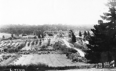
Postcard - Photograph postcard, Old Bridge, Kaylock's Crossing, Brougham Street, Eltham, c.1912
... the approaches involved bends in the road alignment. This bridge... the approaches involved bends in the road alignment. This bridge ...Date estimated to be circa 1912 based on the style of printing on the reverse of the card - Kodak Austral paper for real photo postcards, the paper was manufactured c.1908-1914 (See also POSTCARDS ON KODAK PAPER - IS IT POSSIBLE TO "DATE" THEM? http://tps.org.au/bb/viewtopic.php?t=115) Brougham Street was created in Josiah Holloway's 1851 subdivision of Little Eltham. It was one of several east-west streets shown on the subdivision plan as crossing the Diamond Creek. The western part was named Wellington Street on the subdivision plan but was later changed to conform with the name of the eastern part as acknowledgement of the continuity of the street. It is not known when the first bridge was constructed in Brougham Street however it was certainly mentioned at Council’s meeting of 2 June 1884 as being in a dangerous state of repair. This photo (c.1895) of an old bridge shows a very low-level simple log girder bridge crossing the creek at a right angle and so the approaches involved bends in the road alignment. This bridge was generally known as Kaylocks Bridge or Kaylock’s Crossing after the owner of the adjoining land. It was most likely built from around the mid-1850s, or a crossing of some fashion established as Richard George Kaylock, butcher of Little Eltham and his wife Emily Ann settled there in 1854. His property was in Wellington Street (now Brougham Street) and apparently extended across the Diamond Creek. The land on the western side of the creek was farmed, the house being on the eastern side. Kaylock's Bridge formed part of the original coach road to Eltham and in 1922 was described as an "old rustic bridge". Its low level and insubstantial construction made it susceptible to flood damage, necessitating frequent closures until repairs could be carried out. In September 1922, Council called for tenders for a new timber bridge to be constructed at Kaylock’s crossing. An engineering assessment carried out for the Council by Macleod Consulting at the time of the replacement suggested that the construction details indicate that it was in the 1900s, however this dating could possibly have been the result of numerous repairs undertaken over the years to flood damage. The tender was awarded to Mr Weller of Kangaroo Ground who commenced work in February 1923 on a higher-level timber trestle bridge. Work was slowed due to illness of the contractor and the accidental death of a man in March 1923 following the collapse of the bank after he had jumped into a hole that had just been blasted. The bridge was completed around July 1923 at which point the old structure was pulled up, marking what was described in the ‘Advertiser’ newspaper as the passing of an old and well-loved landmark in the district. In April 1924 the approach to Kaylocks bridge was washed away during the heavy flooding that destroyed the Main Road bridge. The western side was repaired, and an extra span was added to the eastern side using timber from the destroyed Main Road bridge. The bridge was again severely damaged four months later in August 1924 When a lack of finances delayed repairs to the Bridge Street bridge in 1931 (also referred to as Obelisk Bridge at the time), traffic had to detour via Brougham Street for some time. Local residents feared that the Bridge Street bridge might never reopen. Kaylocks Bridge was constantly subject to damage by floods. In the 1934 flood it was submerged by two feet of water. In more recent times the bridge was again severely damaged by flooding and repairs made. A new bridge and adjoining footbridge were constructed in 2009.Digital file only Postcards scanned from the collection of Michael Aitken on loan to EDHS, 2 Sep. 2022michael aitken collection, eltham, postcards, bridge, brougham street, diamond creek (creek), kaylocks bridge, wellington street -
 Eltham District Historical Society Inc
Photograph, Old Bridge, Kaylock's Crossing, Brougham Street, Eltham, c.1895
... in the road alignment. This bridge was generally known as Kaylocks... in the road alignment. This bridge was generally known as Kaylocks ...Brougham Street was created in Josiah Holloway's 1851 subdivision of Little Eltham. It was one of several east-west streets shown on the subdivision plan as crossing the Diamond Creek. The western part was named Wellington Street on the subdivision plan but was later changed to conform with the name of the eastern part as acknowledgement of the continuity of the street. It is not known when the first bridge was constructed in Brougham Street however it was certainly mentioned at Council’s meeting of 2 June 1884 as being in a dangerous state of repair. This photo (c.1895) of an old bridge shows a very low-level simple log girder bridge crossing the creek at a right angle and so the approaches involved bends in the road alignment. This bridge was generally known as Kaylocks Bridge or Kaylock’s Crossing after the owner of the adjoining land. It was most likely built from around the mid-1850s, or a crossing of some fashion established as Richard George Kaylock, butcher of Little Eltham and his wife Emily Ann settled there in 1854. His property was in Wellington Street (now Brougham Street) and apparently extended across the Diamond Creek. The land on the western side of the creek was farmed, the house being on the eastern side. Kaylock's Bridge formed part of the original coach road to Eltham and in 1922 was described as an "old rustic bridge". Its low level and insubstantial construction made it susceptible to flood damage, necessitating frequent closures until repairs could be carried out. In September 1922, Council called for tenders for a new timber bridge to be constructed at Kaylock’s crossing. An engineering assessment carried out for the Council by Macleod Consulting at the time of the replacement suggested that the construction details indicate that it was in the 1900s, however this dating could possibly have been the result of numerous repairs undertaken over the years to flood damage. The tender was awarded to Mr Weller of Kangaroo Ground who commenced work in February 1923 on a higher-level timber trestle bridge. Work was slowed due to illness of the contractor and the accidental death of a man in March 1923 following the collapse of the bank after he had jumped into a hole that had just been blasted. The bridge was completed around July 1923 at which point the old structure was pulled up, marking what was described in the ‘Advertiser’ newspaper as the passing of an old and well-loved landmark in the district. In April 1924 the approach to Kaylocks bridge was washed away during the heavy flooding that destroyed the Main Road bridge. The western side was repaired, and an extra span was added to the eastern side using timber from the destroyed Main Road bridge. The bridge was again severely damaged four months later in August 1924 When a lack of finances delayed repairs to the Bridge Street bridge in 1931 (also referred to as Obelisk Bridge at the time), traffic had to detour via Brougham Street for some time. Local residents feared that the Bridge Street bridge might never reopen. Kaylocks Bridge was constantly subject to damage by floods. In the 1934 flood it was submerged by two feet of water. In more recent times the bridge was again severely damaged by flooding and repairs made. A new bridge and adjoining footbridge were constructed in 2009. Part of a slide show presentation "Bridges & Waterways of the Shire" by Russell Yeoman to the 13 September 1989 Society meeting. The presentation included slides of historic photos from the Shire of Eltham Pioneers collections as well as several recent views.Photo of earliest known crossing of the Diamond Creek at brougham StreetPostcard photo printbrougham street, eltham, wellington street, kaylocks bridge, bridge, diamond creek (creek) -
 Warrnambool and District Historical Society Inc.
Document - Ledger: Warrnambool Shire Letter book 1861-1865, Circa 1860
... Warrnambool, Commissioner of Roads and Bridges, Cross, Carr, Duffy... in matters relating drainage, bridges , roads all vital ...Contains correspondence pertaining to matters of infrastructure in the period of the 1860’s. The period contained within this ledger is very early in the establishment of the district. It shows the co-operation and initiative between councils, government departments and individuals in matters relating drainage, bridges , roads all vital to the development of the region.Fawn cloth on card cover with tan corner and spine binding. Contains alphabetical index at the front. Letters are written on very fine paper.: On the spine is a paper label, “January1861-April 1865.Label inside front cover “Sands &Kenny. Account Book Manufacturers, Stationers &Printers, Collins St Melbourne. The index contains the following names :W G Allan, Bostock, Biggs, Bench of Magistrates Caramut, Niel Black, Commissioner of the Crown Lands Warrnambool, Commissioner of Roads and Bridges, Cross, Carr, Duffy, Davies, Duffus, Fitzmaurice, Horace Flower warrnambool, warrnambool shire, tenders, district roads board, a davies, 1861-1865 -
 Eltham District Historical Society Inc
Negative - Photograph, Bridge Street, Eltham, c.1910
... View from Maria Street (Main Road) along Bridge Street... melbourne View from Maria Street (Main Road) along Bridge Street ...View from Maria Street (Main Road) along Bridge Street, Eltham, looking towards Montmorency. The house on the right at the corner of Susan and Bridge streets was owned for many years by the Hill family until Council bought it in the early 1960s. The house was built in the 1850s or 60s. The house on the left stood on what is now the southwest corner of Susan and Bridge Streets. The Braithwaite family was associated with this house. Orchards in the foreground either side of the Diamond Creek. The line of trees running up the hill to the left represents the Bolton street alignment. Based on hand writing of title on image compared with others, date is estimated at c.1910.This photo forms part of a collection of photographs gathered by the Shire of Eltham for their centenary project book,"Pioneers and Painters: 100 years of the Shire of Eltham" by Alan Marshall (1971). The collection of over 500 images is held in partnership between Eltham District Historical Society and Yarra Plenty Regional Library (Eltham Library) and is now formally known as the 'The Shire of Eltham Pioneers Photograph Collection.' It is significant in being the first community sourced collection representing the places and people of the Shire's first one hundred years.Digital image 4 x 5 inch B&W Negshire of eltham pioneers photograph collection, bolton steet, braithwaite, bridge, bridge street, bridge street bridge, eltham, hill family home, susan street, orchards -
 Myrtleford and District Historical Society
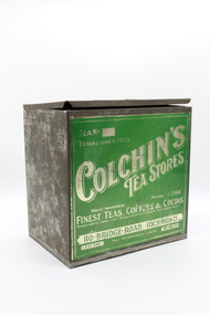
c. 1930s
... BRIDGE ROAD. RICHMOND.. CITY END Your recommendation favoured...Bridge Road , Richmond, Melbourne, Victoria, Australia... BRIDGE ROAD. RICHMOND.. CITY END Your recommendation favoured ...Metal box with a hinged lid, front panel decorated with silver lettering and green background.Tea No 290. Colchin's Tea Stores PHONE J2565 Direct Importer of Finest Teas, Coffee & Cocoas Always over the Commonwealth Standard of extract ~Blends to suit individual Tastes! 110 BRIDGE ROAD. RICHMOND.. CITY END Your recommendation favoured MELBOURNE -
 Melbourne Tram Museum
Slide - Set of 2, John Webster, 14/06/1960 12:00:00 AM
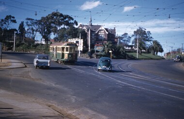
... Bridge or Bridge Road. .2 - Tram 249, showing route 28... turning into Church St from Hawthorn Bridge or Bridge Road. .2 ...Set of two Colour slides, Kodak, white cardboard of trams at the intersection of Burwood Road and Church St Hawthorn. .1 - Tram 320 - route 48, North Balwyn turning into Church St from Hawthorn Bridge or Bridge Road. .2 - Tram 249, showing route 28, turning into Burwood Road, to Burwood Road. Slides dated 14-6-1960.Hand writing on rear in ink .1 - "14-6-60 - 320 - Tram entering Church St Hawthorn on way to North Balwyn or Mont Albert" .2 - "14-6-60 - Tram 249 entering Burwood Rd Hawthorn"trams, tramways, w2 class, burwood rd, hawthorn, church st, route 48, route 28, north balwyn, tram 320, tram 249 -
 Lakes Entrance Historical Society
Photograph - Bridges, 1990
... the Victorian / NSW border, south side of bridge, road to Deddick just... / NSW border, south side of bridge, road to Deddick just visible ...Also another photo taken laterColour photograph showing McKillops Bridge across the Snowy River in the High Country near Deddick, East Gippsland near the Victorian / NSW border, south side of bridge, road to Deddick just visible opposite end, taken from west end of bridge. River flowing to right, bridge of timber, steel and concrete, mountains around. East Gippsland Victoriabridges, waterways, topography -
 Plutarch Project
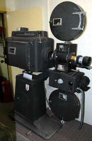
35mm Projector, circa 1950's
... - in a small leatherette on Bridge Road, Richmond. from 1971 to 1985... on Bridge Road, Richmond. from 1971 to 1985 - Galaxy Theatre ...This 35mm Westrex 14 projector was purchased from Waverley Theatre (Cnr Burke Road and Waverley Road in Malvern, in 1962) last used by "Cosmopolitan Motion Pictures" as follows: from 1962 to 1967 - National Theatre, Richmond. from 1967 to 1970 - in a small leatherette on Bridge Road, Richmond. from 1971 to 1985 - Galaxy Theatre Brunswick. After that it was stored at the back of Westgarth Theatre in Northcote. This projector has a primary historic significance as it covers the largest part of the history of film shows by "Cosmopolitan Motion Pictures", and cultural/social significance since it has been used to project a number of other language films (about 10 different languages) by the company. It also carries a secondary significance of rarity being the last used projector by the company at Galaxy Theatre.This metal (most probably steel) projector is part of a number of projectors owned by "Cosmopolitan Motion Pictures". It is in dark blue/grey colour and still operational to project 35mm films if needed. It has two inscriptions detailed below and was last used at Liberty/Galaxy Theatre in Brunswick in 1985 (for more details about the history of Galaxy Theatre follow this link http://technicolouryawn.com/?page_id=2988)INSCRIPTION 1 (red background) Westrex 14, High Intensity Arc Lamp, Serial Number A.5401018. Manufactured for Westrex (Australia) Pty. Limited by G.B.H. Electronic Laboratories - Made in N.S.W. Australia INSCRIPTION 2 (blue background) Westrex R4A Reproducer Made in Australia Western Electric Co. (Aust) Pty. Ltd.projector, film, culture, language, greek, entertainment, γιαννούδης, yiannoudes, προβολέας -
 Ballarat Tramway Museum
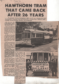
Newspaper, Progress Press, "Hawthorn Tram that came back after 26 years", Sep. 1971
... Road (at Princes Bridge), Melbourne. Quotes Cr Chisholm..." banners and photo of the tram in St Kilda Road (at Princes Bridge ...Provides the story about the visit of No. 36 to the cities of Hawthorn and Camberwell 22/9/1971. Has photo of tram with "Tourism Week Go See Ballarat" banners and photo of the tram in St Kilda Road (at Princes Bridge), Melbourne. Quotes Cr Chisholm of Ballarat. Notes the Hawthorn Tramway Trust and that the tram would be based at Preston Depot for tours. See also Reg. Item 3173.Presents the story of tram No. 36 after it left Melbourne, operated one trip only in Melbourne and then was given to the TMSV later on. Gives relevance of the tram to Melbourne.Newspaper clipping, from the Progress Press 29/9/1971 -titled "Hawthorn Tram that came back after 26 years".2nd copy has the date and newspaper on the top of the sheet.hawthorn, melbourne, ballarat tourism -
 Melbourne Tram Museum
Pamphlet, Public Transport Victoria (PTV), "Buses replace trams - Routes 48, 75, 78", Jan. 2021
... Bridge Road... on routes 48, 75 and 78, during the reconstruction of Bridge Road... Replacement Bridge Road Pamphlet - 4 fold DL, titled "Buses replace ...Pamphlet - 4 fold DL, titled "Buses replace trams - Route 48, 75 78", published by PTV about the replacement of trams on routes 48, 75 and 78, during the reconstruction of Bridge Road Richmond trackwork between 3/1/2021 and 16/1/2021. Has a map of the replacement services. Has PTV and Victorian Government logos. two copies held.trams, tramways, route 48, route 75, route 78, trackwork, bus replacement, bridge road -
 Melbourne Tram Museum
Photograph - Barkers Road cutting and tram 80, A H Enticott, c1915
... the Barkers Road cutting to Victoria Bridge. Has along the bottom... the Barkers Road cutting to Victoria Bridge. Has along the bottom edge ...Photo of PMTT tram No. 80, showing route 6, descending the Barkers Road cutting to Victoria Bridge. Has along the bottom edge the words "by A H Enticott, Victoria Bridge - an instance of topography disregarded." Possibly from a journal with the photo supplied by Mr Enticott, c1915.Yields information about PMTT tram 80.Black and white photograph with notes on the rear.In pencil "Prahran & Malvern"tramcars, tramways, tram 80, pmtt, barkers road -
 Bendigo Historical Society Inc.
Photograph - Kangaroo Flat Gold Mine Collection: Deadhorse Gully, Sydney Flat Creek March 1986
... - Pyramid Road Bridge, looking upstream. 13. Sydney Creek - Pyramid... Bridge, looking upstream. 13. Sydney Creek - Pyramid Road ...Colour photographs, seventeen images on nine page. Images labelled as follows : 1. North New Moon shaft - natural discharge point of Garden Gullly line 2. Actual exit to surface from beneath mullock at North New Moon shaft. 3. Looking into Deadhorse Gully from mullock heap at North New Moon site. 4. Deadhorse Gully downstream of WMC Weir. 5. Sydney Creek track crossing - impassable ford. 6. Sydney Creek looking downstream from ford. 7. Sydney Creek looking upstream from road near Recreation Reserve (12 inch pipe under road). 8. Sydney Creek looking downstream from same point. 9. Sydney Creek - Camp Road, looking upstream.. 10. Sydney Creek - Camp Road, looking downstream. 11. Sydney Creek - Camp Road Culverts. 12. Sydney Creek - Pyramid Road Bridge, looking upstream. 13. Sydney Creek - Pyramid Road Crossing looking downsteam. 14. Sydney Creek - rail crossing, looking upstream. 15. Sydney Creek - rail crossing, looking downstream. 16. Sydney Creek - Airstrip road, looking upstream. 17. Sydney Creek - Airstrip Road, looking downstream 12 inch pipe under road. Lined paper, in blue pen 'Deadhorse Gully-Sydney Flat Creek, March 1986, Photos of Deadhorse Gully/Sydney Flat Creek'kangaroo flat gold mine, deadhorse gully, sydney flat creek, unity mining, water discharge, north new moon, camp road, pyramid hill road, eaglehawk -
 Melbourne Tram Museum
Photograph - Set of 4 Black & White Photograph/s, Don Schulz, mid 1920's
... Bridge Road... in Melbourne at the Bridge Road terminus or city during the mid 1920's... Trams tramways Cable Trams Bridge Road Flinders St Richmond ...Series of four Black and White Photographs cable trams in Melbourne at the Bridge Road terminus or city during the mid 1920's/ .1 - Bridge road terminus with the car house or depot on the left hand side with the destination of Spencer St. .2 - Gripman possibly checking his watch with a depot worker? stepping off the tram. .3 - family stepping off the tram with cable trailer 368 in the view - Elizabeth St, near Flinders St? See Brian Weedon's notes re the photo and the trailer. .4 - As for .1 - with an X marked above the lady and a very large motor car passing. Printed on Kodak Paper. Adam Chandler advised by email 5/8/2020: " note there's a destination box fitted to the grip - from memory, these started to be used from the mid-1920s with the dummy and trailer repaints into the brown colour? That also looks to be either a 1925 or 26 Buick - the "moustache" shape at the top of the front radiator grille and the distinctly angled lower sash of the windscreen are further hints. Given the Richmond line closed in 1927 for conversion I'd say some time between 1924 and 29 June 1927." Also see image i5.pdf for further notes regarding the photographs and the Bridge Road tram depot building - use the original pdf file to read. Image i6, has had the "X" removed - done by Darren Hutchesson.On rear in ink in each print, "Cable car Melbourne" and "286 Anzac Hy/Marion Rd Adelaide SA, collection of late Don Schultz"trams, tramways, cable trams, bridge road, flinders st, richmond depot, hawthorn bridge, tram 368 -
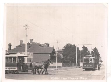 Ballarat Tramway Museum
Photograph - Black & White Photograph/s
... meet', showing a horse tram ( Hawthorn Bridge to Auburn Road... trams ran from Auburn Road to Hawthorn Bridge and connected...', showing a horse tram ( Hawthorn Bridge to Auburn Road (Riversdale ...Black & white photo ex Postcard? titled 'Where two roads meet', showing a horse tram ( Hawthorn Bridge to Auburn Road (Riversdale Road) and Prahran and Malvern No. 36 on Glenferrie Road with Deepdene destination, at the intersection of Riversdale & Glenferrie Roads, Hawthorn. Corner block (SE) behind photo has a 'For Sale' sign on it, with houses in background. Now a block of shops. Tram No. 36 is an F class car, later renumbered - see p14 of Destination City, 4th edition. See also inscriptions. Questions: How horse tram number determined and date of photograph??`` Reimaged 17/7/2017 both front and back.'T101, No. 26 horse tram of Hawthorn Tramway Trust in Riversdale Road. No. 36 toastrack (enclosed cross seat) of the Prahran & Malvern Trams in Glenferrie Road, Hawthorn 1917. Horse trams ran from Auburn Road to Hawthorn Bridge and connected with the Richmond cable trams. W.Jack.'trams, tramways, pmtt, horse trams, riversdale road, glenferrie rd , tram f 36 -
 Orbost & District Historical Society
black and white photograph, January 1934
... a section of the 1922 Orbost bridge, wrecking fences, bridges... a section of the 1922 Orbost bridge, wrecking fences, bridges ...Damage estimated at £500,000 was caused by the 1934 floods in the Orbost district. This 1934 flood was devastating, destroying a section of the 1922 Orbost bridge, wrecking fences, bridges and roads, dumping silt and debris on the rich river flats and drowning cattle. The centre span of the Orbost Bridge was washed away. This item is a pictorial record of the 1934 floods, a significant part of Orbost's history.A black / white photograph showing the flood damage to the Snowy River Bridge. There is a gap in the bridge where the centre span has been washed away. In the background is a punt.orbost-floods-1934 natural-disasters-floods snowy-river-bridge -
 Warrnambool and District Historical Society Inc.
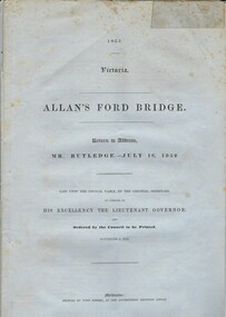
Document, Allan’s Ford Bridge 1852, 1852
... on the local roads and bridges in other locations. The 1852 Allansford... on the local roads and bridges in other locations. The 1852 Allansford ...This is an original Victorian Government document containing the printed version of 37 reports and letters regarding the building of the first Allansford bridge completed early in 1852. The correspondence dates from October 1850 to February 1852 and includes letters and reports from Melbourne Government employees such as Robert Hoddle, Chief Surveyor, David Lennox, Superintendent of Bridges and Lieutenant – Governor Charles La Trobe. The correspondence from local settlers included the names of William and John Allan, John Davidson and James Coulstock. The correspondence shows that some settlers in the Warrnambool/Port Fairy district wanted a portion of the Government allocated funds spent on the local roads and bridges in other locations. The 1852 Allansford bridge cost £480 and was replaced in 1870. This document has strong historical significance as it relates to one of the earliest State government works in the district and records the public imput into the decision.. It contains opinions and correspondence between a number of early settlers in the district at the time.Grey/blue paper document with black text. 21 pages plus 4 page index at back.allan's ford 1852, allansford bridge, allansford, history of allansford, warrnambool -
 Melbourne Tram Museum
Document - Research Notes, H. S. McComb, details of the Hawthorn system - part 3, 1950's
... reports, Bridge Road interchange with the cable trams, Items... to MMTB Annual reports, Bridge Road interchange with the cable ...Set of papers - 12 foolscap - hand written in plain and red pencil giving details of the Hawthorn system, sketches showing changes to the trackwork, duplication dates, lengths of track, level book references, calculations, references to MMTB Annual reports, Bridge Road interchange with the cable trams, Items 2037 to 2041 within box 72.3 in a brown folder marked "Hawthorn Tramway Trust" in red pencil.trams, tramways, htt, hawthorn, reports, routes, track, hawthorn depot, opening, cable trams -
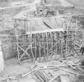 Eltham District Historical Society Inc
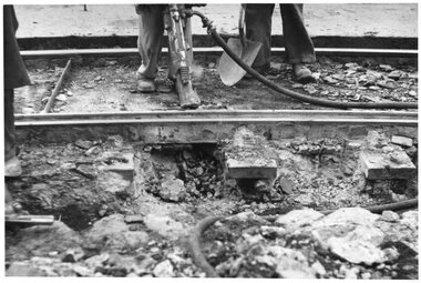
Album - Photograph, J.A. McDonald, Dixons Creek Road, June 1957
... Dixons Creek Road Bridge over Dixons Creek – 56FD330 June... melbourne Dixons Creek Road Bridge over Dixons Creek – 56FD330 June ...Dixons Creek Road Bridge over Dixons Creek – 56FD330 June 1957 Dixons Creek pier forming columns and beam Advertising (1957, January 19). The Argus (Melbourne, Vic. : 1848 - 1957), p. 33 (Col. 9). Retrieved August 24, 2022, from http://nla.gov.au/nla.news-article71777065 SHIRE OF ELTHAM. Loan No. 27.-Notice of Intention to Borrow Sum of £ 15,000 for Permanent Works and Undertakings. - Notice is hereby given, that the Council of the Shire of Eltham proposes to borrow the sum of £15,000 on the credit of the municipal revenues of the president, councillors, and ratepayers for the said shire, such sum to be raised by the Issue of debentures in accordance with the provisions of the Local Government Acts. 1. Maximum rate of interest that may be paid is £5/10/ per cent, per annum. 2. The purposes for which the loan is to be applied are: Construction of Sanitary Conveniences at Shire Office, Council's contribution towards costs of Dixons Creek Bridge, Construction of Mt. Pleasant rd., Construction of Cherry Tree rd. 3. The period of the loan shall be 10 years. 4. Moneys borrowed will be repayable by providing out of the Municipal Fund twenty half-yearly instalments of approximately £985/1/6 each, including principal and interest on the first day of October and the first day of April during the currency of the loan. The first Instalment shall be payable on the first day of October 1957. 5. Such moneys shall be repayable at the Commercial Bank of Australia Limited, Melbourne, or at the Council's bankers for the time being in Melbourne. The plans and specifications and the estimates of the costs of the proposed works and a statement showing the proposed expenditure of the moneys to be borrowed are open for inspection at the Shire Office, Eltham. R. J. HAM. Shire Secretary.Record of various Shire of Eltham infrastructure works undertaken during the period of 1952-1962 involving bridge and road reconstruction projects, sometimes with Eltham Shire Council Project Reference numbers quoted. It was during this period that a number of significant improvements were made to roads and new bridges constructed within the shire that remain in place as of present day (2022). In many situations, the photos provide a tangible visible record of infrastructure that existed throughout the early days of the Shire. The album was put together by or under the direction of the Shire Engineer, J.A. McDonald.infrastructure, road construction, shire of eltham, bridge construction, dixons creek bridge, dixon's creek road, 1957-06 -
 Ballarat Tramway Museum
Photograph - Tram 32 Victoria St, late 1950s
... over the road over the rail bridge for the former Buninyong... over the road over the rail bridge for the former Buninyong ...The photograph shows SEC Ballarat trams Nos. 32 crossing over the road over the rail bridge for the former Buninyong rail line shortly before the Victoria St terminus. The tram has been fitted with reflective triangles on the front dash dated the photo between 1956 and 1960. Photographer unknown.Yields information about tram 32 and the Victoria St rail bridge.Black and White print on plain paper.tramcars, tram 32, victoria st, bridge -
 Melbourne Tram Museum
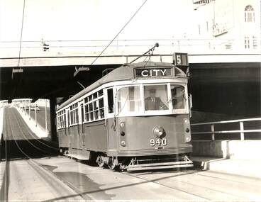
Photograph - Black & White Photograph/s, Melbourne & Metropolitan Tramways Board (MMTB), c July 1970
... inbound on route 5 passing under the St Kilda Junction road over...Melbourne Tram Museum 8 Wallen Road Hawthorn melbourne ...Black and white photograph - large format - of tram W6 940 inbound on route 5 passing under the St Kilda Junction road over bridge with Queens Way St Kilda reserve track in the background. The tram has the destination of City. The tram was the first to be fitted with marker lights - noted in Bourke St 3/7, Herald Sun 3/7 following strong public pressure. See page 5 of the June 1970 issue of Monarail, the magazine of the Monash University Railway club. See also image i2, from the June 1970 issue of TMSV Running Journal with a photo of the tram at the time of the launch. Image provided by Mal Rowe 30-9-2018.trams, tramways, st kilda junction, w6 class, queens way, tram 940 -
 Eltham District Historical Society Inc
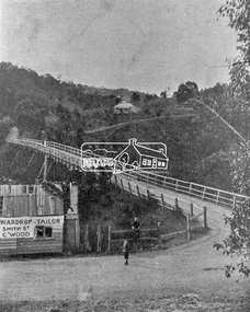
Photograph, Warrandyte Bridge on River Yarra
... . A wooden building on the side of the road before the bridge has.... A wooden building on the side of the road before the bridge has ...Bridge across the Yarra River which links North Warrandyte and Warrandyte. A house sits prominantly on a hill in the distance. A wooden building on the side of the road before the bridge has advertising for Wardrop Tailor, Smith Street, Collingwood. It is suggested that the photo has had this fake information added at a later date. Wardrop Tailor did operate from about 1915 to 1921. Alternataive title: Warrandyte Bridge - River Yarra. "Wardrop-Tailor, Smith St. C'wood" sign - faked?This photo forms part of a collection of photographs gathered by the Shire of Eltham for their centenary project book,"Pioneers and Painters: 100 years of the Shire of Eltham" by Alan Marshall (1971). The collection of over 500 images is held in partnership between Eltham District Historical Society and Yarra Plenty Regional Library (Eltham Library) and is now formally known as 'The Shire of Eltham Pioneers Photograph Collection.' It is significant in being the first community sourced collection representing the places and people of the Shire's first one hundred years.Digital imagesepp, shire of eltham pioneers photograph collection, warrandyte, bridge, north warrandyte, yarra river, wardrop tailor, collingwood -
 Melbourne Tram Museum
Photograph - Set of 15 Black & White Photograph/s, Melbourne & Metropolitan Tramways Board (MMTB), 1950's
... - could be Maribyrnong Road bridge replacement. .13 - Screeding... - ditto - could be Maribyrnong Road bridge replacement. .13 ...Series of 15 black and white photographs of the track works to reconstruct tram lines showing various methods and works during the 1960's. .1 - Jackhammers concrete out around wooden sleepers - the rails have been bolted to them. .2 - Excavated track or temporary track next to newly relaid track - Hawthorn Road by Caulfield Park? .3 - Partly completed work - nearest track relaid, second track still has wood blocks? and then a temporary track. .4 - Excavated previously concreted and bolted track. Appears to be new rail. .5 - Compacting a new track bed with work laying track in the background. .6 - Rail being craned into position onto small concrete blocks - Nicholson St North Fitzroy at Church St - the church is now Melbourne City Mission Palliative care centre. 1955/56 - construction of the replacement track. Note the Hail bus stop sign on the corner. .7 - Thermite welding being set up. .8 - after a Thermite welding joint completed. .9 - track reading for pouting concrete, with a rebuilt track alongside and temporary track on the other side. .10 - ditto .11 - Concrete being poured .12 - ditto - could be Maribyrnong Road bridge replacement. .13 - Screeding off the concrete - possibly Nicholson St North Fitzroy .14 - completed surface - location as above .15 - completed surface with cloth covers to assist the concrete being cured. Has a MMTB hut and two worker amenity buses alongside. - location as above.Some photos have pencil marks on rear.trams, tramways, trackwork, rails, track materials, track repairs, sleepers, equipment, concrete, welding, nicholson st, new tramway, buses -
 Port Melbourne Historical & Preservation Society
Poster, History of a Street Precinct
... of the history of the area bounded by Williamstown Road and Evans, Bridge... of the history of the area bounded by Williamstown Road and Evans, Bridge ...A cultural grant was given to Margaret BRIDE to implement this study, which she did with the help of her husband Graham and several residents of the study area including PMH&PS members Emily LOCK, David THOMPSON, Jack BOLT and Kerrie MATHEE.History of a Street Precinct, documenting 80 years plus of the history of the area bounded by Williamstown Road and Evans, Bridge and Farrell Streets, since 1880. One of two products of a 2005 project (which subsequently won the 2007 Victorian Local History Award for research). A brochure containing a map of the area and photos and information on key properties. An interactive CD (2148.02) containing information and photographs on 91 buildings and their occupants over time was also produced. built environment -
Port Melbourne Historical & Preservation Society
Mixed media, History of a Street Precinct
... of the history of the area bounded by Williamstown Road and Evans, Bridge... of the history of the area bounded by Williamstown Road and Evans, Bridge ...A cultural grant was given to Margaret BRIDE to implement this study, which she did with the help of her husband Graham and several residents of the study area including PMH&PS members Emily LOCK, David THOMPSON, Jack BOLT and Kerrie MATHEE.History of a Street Precinct, documenting 80 years plus of the history of the area bounded by Williamstown Road and Evans, Bridge and Farrell Streets, since 1880. One of two products of a 2005 project (which subsequently won the 2007 Victorian Local History Awards for research). An interactive CD containing information and photographs. This was packaged with a brochure (2148.01) containing a map of the area and photos and information on key properties and individuals on 91 buildings and their occupants over time.built environment -
 Melbourne Tram Museum
Document - Research Notes, H. S. McComb, details of the Hawthorn system - part 4, 1950's
... , junction arrangements, Batman Ave terminus, Bridge Road..., Bridge Road interchange with the cable trams, Items 2037 ...Set of papers - 50 foolscap plain paper sheets - handmade or written in plain and red pencil giving details of the Hawthorn system, sketches showing changes to the trackwork, duplication dates, lengths of track, level book references, calculations, junction arrangements, Batman Ave terminus, Bridge Road interchange with the cable trams, Items 2037 to 2041 within box 72.3 in a brown folder marked "Hawthorn Tramway Trust" in red pencil.trams, tramways, htt, hawthorn, reports, routes, track, hawthorn depot, opening, cable trams, batman ave -
 Warrnambool and District Historical Society Inc.
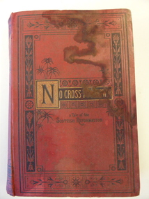
Book, No cross no crown
... at Boughton on the Merri River (near Cassady’s Bridge, Caramut Road... on the Merri River (near Cassady’s Bridge, Caramut Road today ...This book has been given by the Woodford Sunday School to Edith Cassady (note the misspelling of ‘Cassady’). Edith Cassady was the daughter of William and Elizabeth who lived at Boughton on the Merri River (near Cassady’s Bridge, Caramut Road today). This property was established about 1845. The donor of the book was William Wines, a member of a pioneering family in the Woodford district. This book is of some interest as it belonged to Edith Cassady, a member of a pioneering family who lived at Boughton on the Merri River. This is a hard cover book of 344 pages. The cover is red with black border decorations and black and gold lettering. There are several full page black and white illustrations scattered throughout the book which has 23 chapters of story. The cover and pages are much water-stained. The inscription is handwritten in black ink. ‘Woodford Sunday School Presented to Edith Cassidy (sic) by her well-wisher William Wines’ william wines, woodford, history of woodford, edith cassady, boughton property, cassady family -
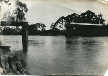
 Orbost & District Historical Society
black and white photographs, Howard D. Bulmer, first half 20th century
... This bridge was built in the 1920s as a road and rail... gippsland This bridge was built in the 1920s as a road and rail ...This bridge was built in the 1920s as a road and rail bridge, and was partly washed away by flood waters in 1934. After the end of the first World War the Victorian Railways considered an extension of the railhead across the river at Orbost, and in 1922 a new timber and steel girder structure, a joint Country Roads Board — Victorian Railways venture, was built and completed at a cost of £41,000 (the steel girders came from the Flinders Street viaduct reconstruction). Subsequently it was decided not to take the railway across the river, and the bridge has only been used by road traffic. This is a pictorial record of an early bridge across the Snowy River at Orbost.A large black / white photograph of the Orbost Snowy River bridge. There is a large copy as well as a postcard copy in sepia.on front - Snowy River Bridge Orbost H.D. Bulmer - photo - Lake Tyers.snowy-river-bridge-orbost -
 Warrnambool and District Historical Society Inc.
Bottle, Bottle fragment Woodford hotel est 1845, 19th century
... This fragment was found in Bridge Road, Woodford... This fragment was found in Bridge Road, Woodford on the site ...This fragment was found in Bridge Road, Woodford on the site of the Travellers’ Rest Hotel, Woodford and it is believed that it may date from the time when the hotel was operating. The Travellers’ Rest Hotel in Woodford was established some time in the 1840s with the first known date, 1847. It pre-dates the settlement of Warrnambool founded in late 1847. The Travellers’ Rest Hotel was established by William Kirby and his wife Mary took over the hotel management when her husband was drowned in August 1847. The hotel had seven other licensees and closed in 1875. If this item comes from the time of the Travellers’ Rest Hotel in Woodford then it is of considerable interest as an early memento of that hotel and the early days of Woodford. This is a fragment of a black bottle or other domestic item. It is made of heavy glass and is curved and could be part of the base of the object. history of woodford, travellers’ rest hotel, woodford, warrnambool history -
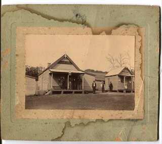 Orbost & District Historical Society
black and white photograph, early 20th century
... and the McKillops Bridge Road" ( from Regional Heritage Assessment 1996... and the McKillops Bridge Road" ( from Regional Heritage Assessment 1996 ...The hotel at Bonang was also known as Clancy's Hotel, Bonang, after its licensee, William Clancy. It operated from the late 1890s until early 20th century. William Clancy was aslo the postmaster at Bonang. A post office operated at Bonang from at least 1859. At the time Bonang was "a small, scattered collection of buildings marking the intersection of the Bonang Highway and the McKillops Bridge Road" ( from Regional Heritage Assessment 1996). As the mining activity declined the township became even smaller as many of the population moved to Orbost,, a larger settlement. This is a pictorial record of Bonang, a small settlement approximately 50 km north of Orbost. The buildings in the photograph no longer exist.A black / white photograph mounted on grey card. there are stains from water damage on the mount. It is a photograph of two single-storeyed timber buildings fronting a wide dirt road. On the right is the Bonang Hotel with four men in suits standing on a verandah. The building on the right is the Bonang Post Office and there are three men outside it. the photograph has been posed. on back - 'Grandma Clancy owned the hotel & Uncle Will had a gold mine which he worked"bonang bonang-post-office bonang-hotel clancy-william clancy's-hotel-bonang