Showing 849 items
matching valley buildings
-
 Kiewa Valley Historical Society
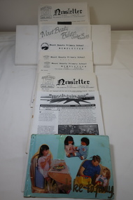
Newsletters - Mount Beauty Schools
Education in Mount Beauty began in the 1940s when the SECV constructed the town of Mount Beauty for their workers and staff. The educational facilities included a kindergarten, a primary / consolidated school and a secondary college. Mount Beauty education was highly valued by the residents of Mt Beauty and families in the Kiewa Valley. In the 1940s and 1950s it was very modern with new buildings and included the latest in teaching aids and technology. A Collection of Mount Beauty Primary School, Secondary College, Mt Beauty Kindergarten Newsletters Dates 1992 - 1997. Note: Photo includes hand made booklet with photos of children at schooleducation in mount beauty, mt beauty school newsletters -
 Kiewa Valley Historical Society
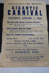
Poster - Mt Beauty Gigantic Carnival, 1960
The residents of Mt Beauty and the Kiewa Valley swam in the local East and West Kiewa Rivers. The community began planning the building of a swimming pool at Mt Beauty in the early 1960s and held events to raise money for it. The building of a swimming pool in Mt Beauty is part of the construction town's development and demonstrates the support of the community, especially the Mt Beauty and District Progress Association, and the SECV.Yellowed paper with black print dated Saturday, January 2, 1960 advertising the events for the day at Mt Beauty. Proceeds to the Swimming Pool.mt beauty swimming pool, carnival, mt beauty and district progress association -
 Kiewa Valley Historical Society
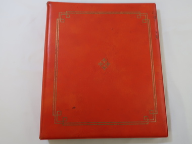
Photo Album - Senior Citizens' Clubrooms, Official Opening of the Senior Citizens' Clubrooms
The Mount Beauty Senior Citizens' Clubrooms were officially opened on the 8th December 1972.The building was built and owned by the (then) Bright Shire after much lobbying and fund raising by a local steering committee. It has served the community well for over 50 years.This album is a significant reminder of how the community of Mount Beauty was always pro-active in the development of community welfare and assets.Orange Vinyl covered photo album circa 1960s-1970s. Inside the covers are 10 double-sided plastic-covered cardboard pages secured by a metal spirex type page holder. Two gold lines with geometric cornice design border the cover. Four snowflake shapes form a diamond shape embossing in the centre of the cover also in gold. Manfacturer -Advance - Style 101220 inside back cover in gold.mt beauty senior citizens club -
 Kiewa Valley Historical Society
Photos - Mt Beauty Schools
Mt Beauty HES school was created for the children of the employees of the State Electricity Commission of Victoria who were constructing the Kiewa Hydro Electric Scheme at the head of the Kiewa Valley at the new town of Mount Beauty. Mt Beauty School consisted of Mt Beauty Higher Elementary School 1948-1964 before it was split into the current (2023) Mt Beauty Primary School and Mt Beauty High School. See. "Kiewa Kids" by Graham Gardner pages 94-180. "Below Bogong-A History of Mount Beauty" compiled by Di Edmondson. chapter 7, Pages 178-230.As the population changed so did the schools in name, size etc. Also what started as a very modern school in the 1948 to what is now an older style wooden building2 larger photos 1 b & w - hurdles race and 1 colored 3 girls sitting in front of computers 9 medium size photos 1 b & w students and 1 of car; 1 of school building and 1 of student group; 5 coloured sports daymt beauty higher elementary school -
 Kiewa Valley Historical Society
Photos - S.E.C. Work on Kiewa Hydro Electric Scheme
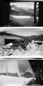
B & W photos - x2 of Homans and x1 of Sawmill with titles in white on the bottom left hand corner. And one other photo of a building in snowHowmans Dam; Howmans Gap; Saw Mill -
 Kiewa Valley Historical Society
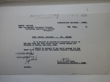
Papers - Mt Beauty Post Office Building
Mt Beauty was built by the SECV during the construction of the KHES. The Mt Beauty Post Office was opened on 4th July 1949The Mt Beauty Post Office is part of Mt Beauty's history. It is still located in the same place and now sells gifts for the tourists, stationary and clothing.Photocopy of letter re Post Office Building - Mt Beauty advising that the Post Office at My Beauty opened for business on Monday, 4th July, 1949. Also photocopies of 4 official SECV photos - 1. The Mt Beauty township Jan. 1948 2. Exterior of the New Post Office Mt Beauty dated July 1949 and 3. Interior of the New Post Office Mt Beauty dated July 1949mt beauty post office -
 Kiewa Valley Historical Society
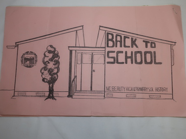
Papers - Mt Beauty High School No.4644, Back to School - Mt Beauty High and Primary School History. See also KVHS 0833
10 points of history pertaining to the History of Schooling in Mt Beauty from 1947 when the SECV and the Education Department erected the school as the population of Mt Beauty grew.A detailed account of the history of schooling at Mt Beauty. Mt Beauty was a construction town run by the SECV when building the KHES.Pink front cover followed by 5 pages of foolscap papers with staple in top right hand corner. Title in black print. In two parts - 1. State School No. 4644 Mount Beauty / Some (10) Points from the School History 2.Mount Beauty High Schoolmt beauty state school, school no. 4644, education -
 Kiewa Valley Historical Society
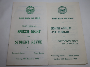
Mt Beauty High School Speech Night 1971 and 1972
Mount Beauty High School was proclaimed in 1963 with 213 pupils, 12 staff members. The enrolments and staff numbers increased as the Kiewa Hydro Electric Scheme continued to be constructed . 1. The Annual Report gives details re Accommodation, Grounds & Buildings, Equipment, Curriculum, Activities, Advisory Council, Cafeteria, Staff and Thanks. 2. In 1972, 27 teachers (names & subjects) are listed as well as other staff. The Reports are similar to that in 1970Mt Beauty High School grew quickly and then declined in numbers as the Kiewa Hydro Electric Scheme was constructed from the late 1940s to the 1960s. It is currently (2023) still operating serving the population in the Kiewa Valley. 1.Pale yellow paper folded x2 opening up to 3 columns of green print. 12 items listed followed by 'Extracts from the Eighth Annual Report. The Report contiues on the back. Front page has logo, title & date 14th Dec. 1970 2. Booklet of 12 pages (6 paper sheets)14 items on page 2, Staff listed on page 3, Principal's Report on page 4- 6. S.R.C. Report page 7, 10th Annual Report page 8-9,President's Report page 10. Scholarships & Awards page 11-12. Front page has logo and title. Tenth Annual Speech Night and Student Revue 12th December 1972 mt beauty high school, speech night programmes 1970 1972 -
 Kiewa Valley Historical Society
Brick - Hand-made Tawonga Brick Factory
Hand-made at the Tawonga Brick factoryMade at the Tawonga brick factory.Formerly KV 106 Rough surface of a hand made brick used for building eg. houseshand-made brick, tawonga brick factory -
 Kiewa Valley Historical Society
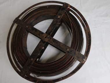
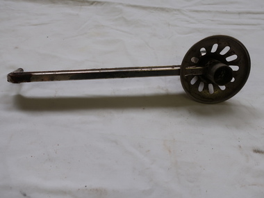
Surveyors Chain - Steel Band
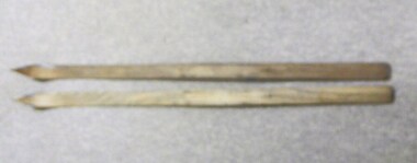
A chain is a unit of length equal to 66 feet or 22 yards. This is a statute measure in the United Kingdom. One link is 100th part of a chain, which is 7.92 inches (20.1 cm). The chain and link became standard surveyors' units of length and crossed to the colonies from the United Kingdom. The chain is the unit of linear measurement for the survey of the public lands as prescribed by law. In Australia most building lots in the past were a quarter of an acre, measuring one chain by two and a half chains. Also street frontages, roads, laneways. The chain also survives as the length of a cricket pitch, being the distance between the stumps. Surveyors and residents of the Kiewa Valley used the Steel Band Surveyors Chain to measure distances when developing the land.Surveyors' steel band measuring tape, known as a 'standard band', or a 'steel band chain'.This chain consists of a long narrow strip of steel of uniform width of 3 mm and thickness of 0.3 to 0.6 mm. The chain itself is between 20 m and 30 m long.surveyors, surveyors chain, measurement of distance -
 Kiewa Valley Historical Society
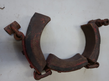
Dray Brake Band, Horse Equipment
Drays were used to transport heavy materials such as farm products, building supplies, food. They were pulled by horses or bullocks. Drays were important for transportation in the Kiewa Valley.Made of timber and steel. The piece of wood contacts the axle hub to brake the dray. Part of a brake for a dray. It is missing the actuator that is needed for tightening the band to operate as a brake.drays, horses, bullocks -
 Kiewa Valley Historical Society
Candle Holder - Wall Bracket
This sconce - wall mounted candle holder or light fixture is simple / basic without any decoration. It was able to swivel. It may have been used on either the interior o exterior walls of buildings. The light is usually, but not always, directed upwards and outwards, rather than down. The long bracket kept the candle a safe distance from the wall and ceiling.This sconce was used by a resident of the Kiewa Valley.Shiny metal rod with candle holder at one end and a small thin rod at the other for attaching to a device on a wall. The candle holder is surrounded by a metal shallow 'cup' with 11 oval holes enabling the wax to fall to the centre where there is a hollow globe and allowing the light to shine upwards.sconce, candle holder, wall mounted candle holder -
 Kiewa Valley Historical Society
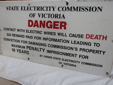
Sign - S.E.C.V
The SECV constructed the KHES and were required to put Safety signs in public and dangerous places.The SECV built the KHES and were responsible for safety signs for the publicLarge metal safety sign warning the public of Danger. Black print with "Danger" and "Death" printed in red. There are 10 holes for erecting the sign onto a eg. building. There is a hole in each corner and one in the centre of the two sides and two equally spaced between the corners of the top and bottom sides.secv safety sign -
 4th/19th Prince of Wales's Light Horse Regiment Unit History Room
Photograph, Australian War Museum, 1917?
A black & white photo showing horses being watered at a stream.On back: Members of the 4th ALH Regiment watering their horses from troughs at Auja in the Jordan Valley Palestinephoto, 4th light horse, jordan valley -
 Kiewa Valley Historical Society
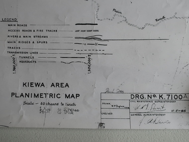
Map - Kiewa Area Planimetric Map
Planimetric maps are two-dimensional representations of the Earth's surface, showing the location and spatial arrangement of features such as roads, buildings, and bodies of water.A very clear map showing the Kiewa Hydro Electric Scheme in two dimensions to include the construction done by the SECV.Black and white Map of the Kiewa Area from Mt Beauty to the High Plains covering the Kiewa Hydro Electric Scheme and surrounds. Drawn on 11th May 1966kiewa hydro electric scheme 1966 -
 Kiewa Valley Historical Society
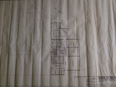
Plan - Shire of Bright - Mt Beauty Swimming Pool and Sporting Complex 1985 x2
Mt Beauty residents swam in the local rivers. The new complex was safer and included amenities eg. toilets, change room etc. It was easier to supervise and teach swimmers and to develop their skills in water.The swimming pool enabled residents and visitors of the Kiewa Valley to swim in safety and to improve their water skills.Two Black and White plans each showing the proposed buildings and pool areas of the Mt Beauty Swimming Pool and Sporting Complex. Dated 26th June 1985mt beauty swimming pool, shire of bright -
 Kiewa Valley Historical Society
Maps - Kiewa Valley Parish Maps x3 and Kiewa Area Planimetric Map x1
Planimetric maps are 2 dimensional representations of the Earth's surface, showing the location and spatial arrangement of features such as roads, buildings, and bodies of water. The parish maps show the occupiers with leases or licences of the land. These are updated by the Department of Lands regularly. The names of early settlers of the Kiewa Valley occupying land by lease or licence are shown. Many of these familie's descendants still live in the Kiewa Valley.1. Kiewa Area Planimetric Map (photo) 2. Wermatong, County of Bogong Parish Map 3. Mulllindolingong, County of Bogong Parish Map 4. Mullagong, County of Bogong Parish Map All black and white kiewa valley. parish maps. land owners -
 Kiewa Valley Historical Society
Skis, 1944-45
Skiing was first done at Falls Creek with the building of the towns of Bogong and Mt Beauty. European workers to the Hydro scheme thought that Falls Creek would make a good skiing village. The first ski lodge being opened in 1947. These skiis would have been used in those first seasons of Falls Creek and used by the first skiers of the time from 1945 onwards.These skiis are historically and socially significant, as they would have been one of the first type of skiis used at Falls Creek, one of Victoria first ski resorts, and used by the pioneers of skiing in Victoria. This item has good interpretive capacity as it shows the style of skiis that were used in the 1940's and they are a good comparative item against modern skiis. These skiis were used by Bill Bertram during the first winter traverse from Mount Hotham to the Mountain Creek base of Mount Bogong, see KVHS 0161 for biography of this historical event.Painted Red base with blue undercoat with center groove from base to 3/4 of way towards tip At tips are square pices with round holes possbily HOME MADE? 21 plus 2 holes on top face (for binding)sport, pioneers, snow, skiis, skiing, falls-creek, bogong-village, mt-beauty -
 Kiewa Valley Historical Society
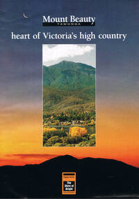
Poster Brochure, Mt Beauty Tawonga Heart Of Victoria's High Country, Circa 1995
The Item is a pictorial time piece of the valley and usage, farms,industry,town area, vegetation and winter snow levels Historical and the social-economical development at circa 1995 of land usage and residential buildings style.Major social events e.g. Festival of the Bogong Moth and the Mt Beauty Mardi Gras. It is also a good historical record of tourism campaigns of the Alpine Shire and Mt Beauty Chamber of Commerce. Also see "KVHS 0125"Brochure folds out from a 20.5cm x 29.5cm to 82cm x 29.5cm poster type documentinside panoramic photo of snow tipped alpine mountain range incorporating the Mount Beauty township, farming area of the Kiewa Valley and relevant tourist orientated informationtourism mt beauty tawonga photographs, victorian alps -
 Kiewa Valley Historical Society
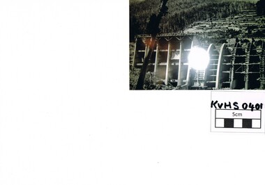
Photograph Junction Dam, Photo Junction Dam and Bogong Village in Background, circa 1950s
This item clearly shows the conditions covering both working conditions and housing in the construction of the Junction Dam in the 1940s. Working conditions were extreme and health and safety legislation was at its infancy. The residential buildings were intended to last only for the period of construction, however greater demand for longevity as a tourist haven prevailedThis photo of the construction of the Junction Dam, with The Bogong village as backdrop, details the harsh conditions faced by construction workers, building dams and villages to accommodate workers in the 1940s to the 1950s. Australia at this period in time, experienced a surge of population (influx of World War II refugees), which was the catalyst for developing and undergoing an enormous hydroelectricity program for the Alpine regions, both in Victoria and New South Wales. This program was initiated to supply electricity to the major southern Australian cities of Adelaide, Melbourne and Sydney. It was thought that these developments would reduce, if not eliminate, the requirement for coal driven power stations. However time has demonstrated that these power stations have not matched the demand required by the industries and the populations of the major urban and cities.Black and white photo of original photo with a flashlight reflection in the bottom centre. The photo is on Kodak XtraLife II paper. The paper is semi gloss.This photo is of the construction of the Junction Dam Wall with the Bogong Townshiip in the background.Back of photo is printed " Kodak XtraLite II paperdam construction, bogong village, alpine development, junction dam -
 Kiewa Valley Historical Society
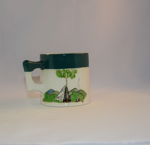
Mug Stoneware
This ceramic mug is titled "Bill Bogong's Mug" in honour of one of Australia's Scouting (Rovers) notable office holders, Mr.W.F."Bill" Waters. He was born on 22nd August 1897 in Taralgon, Victoria, Australia and died 8th October 1968 in Fitzroy, Victoria. He was instrumental in the Rovers building two chalets in the Victorian Alps. The Victorian Award of the National Rover Service Award(1980) has been named after Bill Waters. Bill Waters was also the leader of the first team that climbed Mount Bogong in winter in 1929. Also was part of rescue team of what is now know as the Cleve Cole tragedy on Mt Bogong in the mid 1930's. There is also a water fall named after him Waters Falls on the Bogong High Plains. W.F."Bill" Waters aka "Bill Bogong" (Bogong mountain, were his ashes were scattered), was not only a prominent bush walker (Melbourne Walking Club) of the high country (Victorian Alps) but was instrumental in establishing two Chalets. One of these Chalets was the first one to be built on the Bogong High Plains. This item, "Bill Bogong's Mug" is what the Flinders Petrie(famous English Egyptologist/Archaelogist) Rover Crew(formed in 1940) presented newly invested members of the exclusive(200 membership) Alpine Rover Crew. The Melbourne Walking Club has a long history with the Victorian High Plains area, of which the Kiewa Valley is an integral part of the Victorian Alpine Region. Due to the connections Bill Waters has with the Bogong High Plains and Mt Bogong this cup has a lot of significance to the social history of the area.. Round glazed stoneware mug, white in colour, with a heritage green coloured band covering the top rim and handle. Written inscription on the front "Bill Bogong's Mug" in large print and beneath it, in smaller print, "with compliments from Flinders Petrie Rover Crew" The other side of the mug is a free hand landscaped drawing of green bush and blue hills with a tree supporting a tent and a camp fire (with smoke rising from it).To the left of the inscription is the Scout (Rover) emblem coloured black with an unraveled and unwritten signage scroll fowler ceramics, local alpine history, alpine rovers, scouts, mugs, mt bogong, bogong high plains -
 Kiewa Valley Historical Society
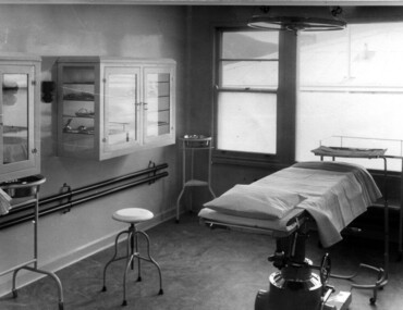
Photograph Tawonga District Hospital, Theatre at Tawonga District Hospital, 1949/50
The original Tawonga District Hospital was situated at the corner of Ryder's Lane and Kiewa Valley Highway. The construction was initiated by the Hospital and Charities Commission with considerable assistance from the State Electricity Commission.The building was transported from Bonegilla where it was originally a part of the Bonegilla Military Hospital. It started with 12 beds and eventually increased to a total of 35 beds. "Add ons" provided theatre, offices, stores and Nurses Home. It was officially opened on 24th September, 1949. Up until this time, any person requiring hospitalisation had to travel to Yackandandah. This photograph is of the theatre and there was no anaesthetic or recovery rooms. While rather primitive by todays standard, it met the demands of the construction days as well as that of the Kiewa Valley community. Shows the rather spartan conditions and equipment of the theatre in the original Tawonga District Hospital compared to the present day hospital. Black and white photograph of the operating theatre in the original Tawonga District Hospitalhospital, operating theatre, tawonga -
 Kiewa Valley Historical Society
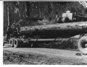
Photograph, logging at McKay Creek, Logging at McKay Creek, 1949/50
This photo was most likely taken at the site of the proposed McKay Creek Power Station. Excavation of this site was commenced in 1951 but an access road (a rough, narrow track) was put it in 1948 and widened in 1954. The State Electricity Commission would have milled logs from this area at their mill at Howman's Gap. The timber was used for building of housing and camps and provided a much needed resource as there was a general shortage of this commodity. The power station was relocated underground owing to repeated problems with landslides in the area. Restricted financial resources and the repositioning of the power station retarded construction activities and it was not completed until early 1961. An historical pictorial record of the type of machinery used in the 1950's - logging truck with bogie attached, the bull dozer and winch for hauling logs to the truck and note the lack of protective clothing!Black and white photograph showing a logging truck, bogie and bull dozer with winch for hauling the logs to the truck. Two men are on the truck, a driver on the bull dozer and a large log on the bogie. Hand written on the back of photo "Logging at McKay Creek".logging, mckay creek, timber, machinery -
 Kiewa Valley Historical Society
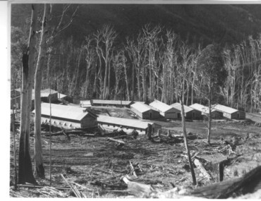
Photograph of Howmans Dam Camp, Howmans Dam Camp, circa 1948
Howman's Gap camp was erected in 1948. The proposed dam to be built at this site was postponed in 1954 because of financial restraints imposed by the government at this time. It was to have supplied water for No. 2 Power Station at the Junction of the Pretty Valley and Rocky Valley branches of the East Kiewa River. This power station was not constructed until 2008 - 2010 and now gets it water from McKay Creek Power Station. The site of this camp is now occupied by the Howman's Gap Alpine Centre. Some of the original buildings still remain. An excellent photographic record of the type of buildings and size of the camp for accommodation of workmen during construction of the Kiewa Hydro Electric Scheme.Black and white photograph of the buildings erected at Howmans Dam site as accommodation for workmen.Handwritten in blue ink on the back of photograph "Howmans Dam Camp"howman's gap, camp, water, dam -
 Kiewa Valley Historical Society
Book - Reference S.E.C. History x4, Brown Power A Jubilee History of the State Electricity Commission of Victoria, first published 1969
Although this book revolves around the supply of power(Electricity) from brown coal it does cover the period 1937 onwards when the Kiewa Hydro Electricity Scheme was first mooted. This area was believed to be far away from aerial bombardment should the coastal power stations be attacked by air in World War II(1939 -1945). After the war, post 1945, the demand for a continual power supply, not affected by seasonal coastal flooding was together with a lower cost of hydro electricity power the major incentive for the Victoria Government of the day to proceed (in the 1940s) with The Kiewa Hydro Electricity Scheme. In 1946 Victorian government sought greater independence from the New South Wales black coal supplies.The significance of this book to the Kiewa Valley and its outlying regions is that it details why the development of an Alpine region was and now still is pocketed with a European flavour both in buildings and in town vegetation(trees and flowers). European (post World War II refugees) where attracted to these alpine areas not only for hard labouring positions but also for their technical skills and some street names offer a distinct European lineage rather than convict or of earlier English settler. The construction phase accommodation continued after completion of the Kiewa Hydro Electricity Scheme to become popular venues for an increasing winter tourism industry. This book has a brown hard cover encapsulated by a cream sleeve with brown and black print. On the front of the sleeve is an embossed circular motif with centre piece S.E.C. emblem and around this the words "50 YEARS OF SERVICE" and below this" STATE ELECTRICITY COMMISSION OF VICTORIA". The book contains 313 double sided pages of black print and black and white photographs.On front of paper sleeve "Brown Power A Jubilee History of the State Electricity Commission of Victoria Cecil Edwards". On the second page, below the Title "Brown Power" there is a pasted, printed presentation certificate, with the S.E.C. emblem and these printed words " Presented by the Chairman and Commissioners to A.G. MILLIST, ESQ. in recognition of long and valued service with the Commission"electricity, victorian power supplies, hydro electricity, brown coal, cecil edwards -
 Kiewa Valley Historical Society
Photograph of Clover Power Station, No. 3 Power Station, after May 1944
In July, 1941 work commenced on the site of the power station with the building of a coffer dam and excavation for the power station building and machine foundations followed. Work proceeded, and the access bridge, transformer foundations and transfer track were completed in April, 1943 and the power station building in May, 1943. Installation of the machines was then proceeded with and No. 1 machine was run for the first time in June 1944. No. 2 machine was completed in April, 1944 and placed in service in May.A pictorial record for the State Electricity Commission of the first Power Station commissioned in the Kiewa Hydro Electric Scheme.Black and white photograph of the bridge and entrance to No. 3 Power Station (Clover Power Station).Handwritten on back of photograph in blue ink "No. 3 Power Station".clover, power station, machine, kiewa scheme -
 Kiewa Valley Historical Society
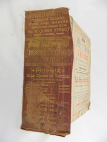
Book - Reference Melbourne Directory, Melbourne and Suburban Directory for 1889, Circa 1889
This Directory of 1889 covers the location of Melbourne based trade and professional offices by street and in Alphabetical order. It covers all of Melbourne and its suburbs. It also covers government and official, ecclesiastic, legal, municipal and miscellaneous information. The directory details a cross section of a developing city with a splattering of advertisements opening up an in depth look of all aspects of living in the late 1800s. It is interesting to see that all the advertisements do not have any telecommunication numbers listed (personal shoppers or mail orders only). This was a period of high moral standing within the community and hotels advertised rooms " suites of rooms for families and single rooms for Ladies and Gentlemen" also "electric bells throughout the house. Telephone, night porter and hot and cold baths."This directory would be used by the majority of families and businesses working and living within the Kiewa Valley and the surrounding area. Melbourne was the only place where every aspect of living requirement was catered for. Although the delivery of services and goods were not at a high rate, certain items or transactions would require a visit to "the big smoke". Business information are listed both by suburb and alphabetically. There is also a section for British and Foreign Trade. This directory covered nearly everything to do with commerce, an example pay days for principle firms. Greater evolution of trade locations started to balloon out after the mid 1950's. Increased populations and greater levels of communication and safe fast transport facilities permitted greater devolution of commercial enterprises into rural communities, such as the Kiewa Valley.This directory has no front or back cover and is held together by its cloth spine. It contains over 1300 pages, however there may be some pages missing front and back of the directory which would have contained advertisements of some unknown shops. All the sides of this directory (except the spine) have advertisements and content information stamped on. The spine cover has been placed in the directory until further conservation work is carried out. It has gold coloured printing and in the central section, a gold coloured background with the words "Sands & McDougall's Melbourne Directory 1889." The spine has three adverts on the spine.On the spine in gold colour "South * British insurance Company Fire and Marine. Risks Lowest Current Rates No. 11 Queen Street, Arthur J Masters, Manager" and half way down " *Phoenix* Fire Office of London established over 100 years Annual Income exceeds (pound sign) 1,000,000" underneath "Losses Paid Over (pound sign) 16,000,000" underneath "Reserve Fund Exceeds (pound sign) 1,000,000" underneath "9 Market Buildings William Street, Melbourne " underneath " R. Manfield Taylor, Agent" and at the bottom section" Henry Scott Auctioneer and Estate Agent 49 Bridport St., Albert Park" stamped on the bottom side across the page endings "The Wonderful Wertheim Sewing Machines Swanston Street opposite Town Hall", stamped on the top side across the page endings " The Sweet Hapsburg Pianos & Organs Swanston Street Opposite Town Hall"state government listings, names and location of early melbourne population business names, 1889 members of the victorian executive council -
 Kiewa Valley Historical Society
Photograph of Pretty Valley Workers Camp*, Pretty Valley Camp, circa 1949
Erection of staff quarters at Pretty Valley was completed in April, 1947 and accommodation for construction workers commenced in 1948 but suspended on 11th May for winter and resumed on 9th November. Construction of this camp was completed in 1949. A large dam was proposed at this site but was never constructed. Instead a small diversion dam was built which diverts water either to Rocky Valley Dam or to McKay Creek Power Station.An historical record of the type of accommodation provided for workmen during the construction of the Kiewa Hydro Scheme during the 1940's/50's.A black and white photograph of Pretty Valley Camp, c 1949. Dead trees are in the foreground, on both the left and right side of the photograph and a small snow gum is evident. There are camp huts and a much larger building behind these, possibly a workshop, and power poles are evident bringing electricity to the site.Handwritten in blue ink on back of photograph "Pretty Valley Camp. 5600 ft. above sea level".pretty valley, dam, water, workmen, camp -
 Eltham District Historical Society Inc
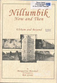
Book, Marguerite Marshall, Nillumbik Now and Then: Eltham and Beyond, by Marguerite Marshall, photographs by Ron Grant, 2002
As a journalist with the former Diamond Valley News, Marguerite Marshall wrote a series of articles on local places of historic interest, later published as the small book "Eltham Shire - Historic Buildings and Places" (1983). Many years this expanded version was published under a new title "Nillumbik Now and Then: Eltham and Beyond". ISBN 0-9580553-0-0 Three copies plus one additional copy of same edition but slight typeset variations to cover and photos throughout book 46 p. : ill., maps ; 30 cm.[written inside front cover of one copy] Best Wishes to the Eltham District Historical Society - Marguerite Marshalleltham shire, shire of nillumbik, shire of eltham, historical buildings, landmarks -
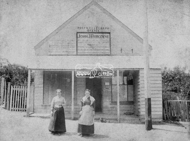 Eltham District Historical Society Inc
Photograph, Hunniford’s Eltham Post Office, Main Road near Bridge Street, Eltham, c.1888
Sepia photograph of Hunniford’s Eltham Post Office, Main Road near Bridge Street, Eltham, c.1888 (Postmistress Anne Hunniford possibly on left). The building originally had a shingle roof. Anne Hamilton born 1814 Co Tyrone, Ireland married Michael Head Burgoyne (1820-1843) in 1839, Co. Tyrone, Ireland. They had two children, Charlotte Caroline (1840) and John James Thomas Neville (Londonderry, Ireland 1844) Whilst pregnant with John, husband Michael died. Following John’s birth, she emigrated to Victoria, Australia where she married Thomas Hunniford in 1854. Daughter Anne Jane Hunniford was born in Eltham in 1855. Anne (Annie) Jane Hunniford and John James Thomas Neville Burgoyne were half siblings. In the mid 1860s Annie Hunniford succeeded her father, Thomas Hunniford as Post Mistress for Eltham. Photo dated based on advertising on façade of the building by Annie’s half-brother, John James Thomas Burgoyne promotes his services as the area manager for John M’Ewan and Co, Auctioneers as well as him being agent for the National Mutual Life Association of Australasia, National Insurance Company of Australasia, Federal Mutual Livestock Association of Australasia, and as a House, Land, Estate, Insurance and Financial agent. This was the time period that he placed advertising for same in the local paper. Australia Post: Gold brought life to the township - Diamond Valley News, Tuesday July 2, 1985, p17 On February 1, 1854, the first Eltham Post Office was established, commencing an association between the township and the Postmaster-General's Department that has continued for 131 years. At that time, the number of permanent residents would have been fairly small, probably less than 200. The discovery of gold in June 1851, at Anderson’s Creek, some five miles away, and later at Caledonia Diggings, Queenstown (now known as St Andrews), about 14 miles to the north-east, brought large numbers of prospectors passing through the township, hopefully culling the creeks and gullies for the precious metal. This additional "floating population" brought a greater demand for supplies and for communication with the outside world, and so it helped in the development of Eltham. Today, Eltham is a thriving township. It boasts an excellent shopping centre, municipal offices, court house. post office and many other amenities. Eltham continued to develop at a leisurely pace. During 1860, a total of just over 8000 postal articles were handled at the Eltham Post Office. By 1862, the mail route was "to and from Melbourne by way of Eltham and Kangaroo Ground, three times a week, by coach". There was also a branch mail that operated between Eltham and Greensborough, three times weekly. This was also conveyed by coach. Some time between 1864 and 1868 the management of the post office passed from Thomas Hunniford to his daughter, Miss Anne Hunniford, who managed the Eltham Post Office until her death in 1928. A big improvement in communication was provided for Eltham residents when a telegraph office was established at the post office in 1877. During 1923 a manual telephone exchange was provided at Eltham, the first two subscribers being J.J. O’Connor and Eltham Police Station. In 1949 the manual exchange was replaced by an automatic exchange and there were some 150 subscribers. Following the death of postmistress Miss Anne Hunniford in 1928, B.M. Burgoyne was placed temporarily in charge of the office. In 1929, J. N. Burgoyne was appointed postmaster, and he in turn was succeeded by H. C. Burgoyne in 1951. The post office was moved to a new site in 1954, but continued under the charge of Mr Burgoyne. In January 1958 there was a further change of site when the post office was raised to official status and transferred to new premises in Main Rd. William Donoghue was acting postmaster when the new office was opened. In March 1958 Mr W.E. Tovey was appointed postmaster, followed by Douglas McG. Gilmour in 1959. William Donoghue was fully appointed in 1966 and Barry Reichelt followed in 1973, prior to the present postmaster, Peter Jolly in November 1982. Peter is a young man with 18 years' experience. He commenced his training as a postal clerk at the training school in Melbourne in 1968 and was promoted to postal clerk at the Brunswick Post Office in 1969. He was finally transferred as postmaster to Fawkner Post Office in 1980. He has been at Eltham Post Office for the past 2½ years. He is married with one child and lives in Montmorency. The Eltham Post Office employs a staff of 21, of whom seven are indoor staff, 12 are postmen and two are drivers. The postmen in Eltham have an uphill battle delivering mail because of the hilly terrain. Nine of the postmen deliver mail on motorbikes, and the two delivery vans are both four wheel drives. Eltham Post Office services basically a residential area, with deliveries to 5600 homes. This is growing at the rate of 600 homes every 18 months, i.e. about 32 homes per month. At the present rate we will need a new postman every 18 months.Sepia photograph (two copies plus two black and white enlargements)Shop originally had a shingle roofpost office, eltham, main road, anne jane hunniford (1855-1928), federal mutual live stock insurance association of australasia, federal mutual livestock association of australasia, john j burgoyne, john m'ewan and co. auctioneers, national insurance company of australasia, national mutual life association of australasia