Showing 6786 items matching "hotel"
-
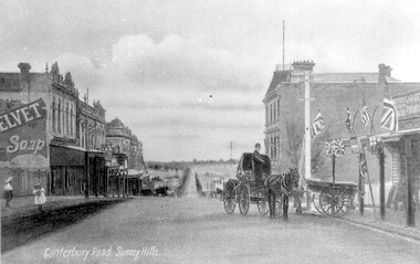 Surrey Hills Historical Society Collection
Work on paper - Photograph, Canterbury Road, near the corner of Union Road, 1911
J A Geer's grocery store operated from 1909-1912 on the site established by George Sim in 1884. He bought a house and added a shop where, in 1889, he established the first post office in the area. Prior to this residents had to go the Box Hill to collect mail. Date is approximate.This records one of the earliest businesses in Surrey Hills. To begin with, businesses developed along Canterbury Road rather than Union Road, in part because of the muddy nature of the land north of the railway line.Black and white photo taken from a postcard of Canterbury Road, near the corner of Union Road, looking west in 1906 or 1907. Two children play on the LHS of the street and there is a man on a horse and carriage, and a cart, on the RHS. Buildings on the RHS are the Surrey Family Hotel and J A Geer's grocery store; on the LHS is a row of double-storey terraces including Hansen's Terrace on Canterbury Road to the west of Union Road.On LHS within the original image is 'Canterbury Road, Surrey Hills'; on the rear in top LH corner in blue biro in Jocelyn Hall's handwriting "J H / spare"canterbury road, geer's grocery store, surrey family hotel, businesses, horse drawn vehicle, hansen's terrace, post card, mr j a geer -
 Linton and District Historical Society Inc
Photograph, East Side of Sussex Street, Linton, 2014
One of three colour photographs which have been printed on a single sheet of photographic paper. The photograph shows the view to the south along the east side of Sussex Street. The former public library building, the Historical Society building (formerly Nelson Bros Undertakers), the Railway Hotel, the former CFA building and other shops and houses can be seen on the left of the photograph, which was taken by Gary Hunt in 2014.linton public library building, linton & district historical society resource centre building, railway hotel linton, cfa building linton, sussex street linton -
 Melbourne Tram Museum
Negative, Wal Jack, 17/05/1942 12:00:00 AM
Black and white negative, by Wal Jack, of the installation of the junction between Union Road and Maribyrnong Road, Ascot Vale. Shows a W Leech mobile crane, a few workers and many bystanders supervising the work. Two uniformed tramway (driver and conductor) are on the right hand side of the photograph. In the background is the Union Hotel. Photo dated 17-05-1942 in the Wal Jack album along with details of the location.trams, tramways, trackwork, union road, maribyrnong rd, new tramway -
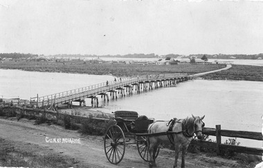
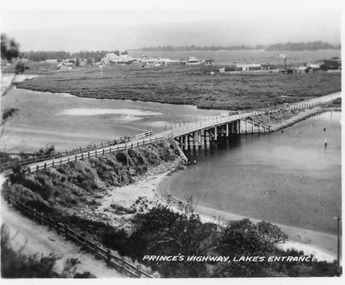 Lakes Entrance Historical Society
Postcard - North Arm bridge Lakes Entrance Victoria, 1920c
Also 2x identical fade P)1151-2,3Black and white miniature postcard of the concrete bridge spanning the North Arm, showing the bridge and abutments,road to bridge from Kalimna, and post and rail fences along road, grass covered mud flats with Club Hotel, Methodist Church and Maranui Guesthouse in distance amongst other buildings. Cunninghame Arm and sand hummocks in far distance. Sandbars visible in North Arm. Lakes Entrance VictoriaPrincess highway Lakes Entrancebridges, coast, religion, hotels, guesthouses -
 Lakes Entrance Historical Society
Postcard - North Arm bridge. Lakes Entrance Victoria c1900, Cooper Alexander, 1900c
CunninghameSepia coloured postcard of first bridge over North Arm, showing view of town buildings, including Club Hotel; sand hummocks; Cunninghame Arm; die back of melaleuca on sand flats. In foreground post and rail fence beside road, two wheeled horse drawn vehicle, jinker, with grey horse standing in shafts. Ten or eleven people standing on bridge. Lakes Entrance Victoriatopography, bridges, transport -
 Greensborough Historical Society
Photograph - Digital Image, Marilyn Smith, Old Mernda Market 2018, 27/09/2018
In 2018 GHS members visited Turner's Bakery in Mernda for lunch and continued on to visit historic sites remaining in the Mernda area. This photograph shows remnants of the Mernda Market, established in 1919 as a livestock market. It was sited on Plenty Road in the carpark of the Bridge Inn Hotel. It evolved into a weekend 'trash and treasure' market although livestock auctions still took place on Mondays. In 2012 the livestock auctions moved to Whittlesea Showgrounds.Mernda is an area of rapid modern growth with a few remaining historic buildings dating from the 19th century.Digital copy of colour photographsmernda, mernda historic sites, mernda market, plenty road mernda, livestock auctions, trash and treasure markets -
 Phillip Island and District Historical Society Inc.
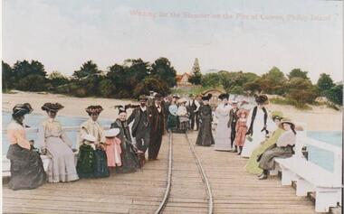
Photograph, Cowes Pier, Phillip Island, 1920
A group of twenty-two people seated and standing on the Cowes Jetty, which was built in 1870. Trolleys on iron rail were used to convey goods along the Jetty. Slightly obscured by people is the Jetty Shed, built in 1870 and now classified by National Trust. Beyond water and beach are trees and shrubs. One gap mid centre depicting The Isle of Wight Hotel - licensed in 1870 - and a large Norfolk Pine.Group waiting for ferry "Genista" on the Cowes Pier.Waiting for the Steamer on the Pier at Cowes, Phillip Islandlocal history, photographs, jetties, cowes, phillip island, colour tinted from black & white photograph, mary robb -
 St Kilda Historical Society
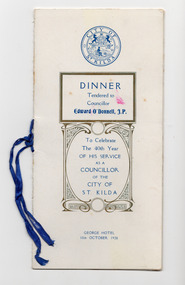
Ephemera - Program, Dinner Tendered to Councillor Edward O'Donnell, J.P
Edward O’Donnell's service as a St. Kilda Councillor included six terms as mayor. The dinner, held by the City of St Kilda at the George hotel on 10 October 1928, celebrated his 40 years of service. The program includes a record of his service, the menu, toasts, and autographs of people who attended. He served for another four years, and left after being defeated in the council elections in 1932.Booklet with a white folded card cover, discoloured with age, printed in blue with gold decoration. Inside, a white page folded in half, printed in blue, is fastened to the cover with a blue ribbon.Autographs written in pencil appear on the final page and inside back cover.edward o'donnell, st kilda council, george hotel -
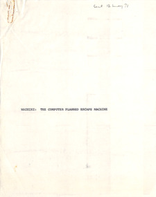 Robin Boyd Foundation
Document - Manuscript, Robin Boyd, Waikiki: The Computer Planned Escape Machine, 1971
Extols the virtues of Waikiki as a holiday destination/escape machine, the less-than-Good Taste of the resort combined with its virtues/religious dogma of American middle-class vacation standards. Boyd describes a day of the typical young American hotel occupant, and Honolulu's uniform air of confidence attracting American tourists. This manuscript was published in 'The Sunday Australian' with the title ‘Why I love Waikiki’ on 23/05/1971.Original manuscript of ‘Why I love Waikiki’ published in 'The Sunday Australian', 23/05/1971.Typewritten (1 c copy and 1 p/copy), pencil edits, quarto, 11 pagesSent 12 May 71 - in pencil on front pagewaikiki, honolulu, american tourism, second rate californian architecture, american middle-class vacation standards, robin boyd, manuscript, ohm2022, ohm2022_16 -
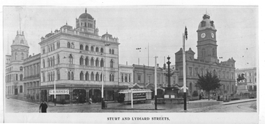 Ballarat Tramway Museum
Photograph - Illustration, "Sturt and Lydiard Streets", c1910
Illustration titled - "Sturt and Lydiard Streets" Shows an ESCo tram with all the blinds drawn in Sturt St just to the west of Lydiard St. Has the National Mutual building with C Marks & Co jewelers, Craigs Hotel, and the Town Hall in the view. On the rear is another view of Sturt St, not the full width of the original item, with an ESCo tram at the intersection with Armstrong St. Has Snows and Shoppee's Square in the view.Yields information about Sturt St at Lydiard St and Armstrong St.Illustration cut from a magazine or publicationballarat, illustrations, sturt st, lydiard st, esco, armstrong st, town hall, national mutual, craigs hotel -
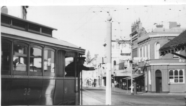 Ballarat Tramway Museum
Photograph - Grenville St signal switch, Keith Kings, 12/4/1958
Photograph shows the motorman of tram 32 selecting the correct signal light for his passage into Bridge St to either the Victoria St or Mt Pleasant Routes. Also allowed the tram to shunt at the intersection and return along Sturt St. See page 44 of the photographer's book, The Ballarat Tramways published in Sept. 1971 - item 114. Has the Buckshead Hotel in the background. Dated 12/4/1958. Yields information about the operation of the Bridge St / Grenville St signal.Black and white photograph with photographers details and information on rear - Keith Kings No. A(l)(13)See image 2ballarat, trams, tramways, sturt st, bridge st, tram 32, signals, forest city signals, grenville st -
 Clunes Museum
Photograph
BLOWN UP PHOTO OF VIEW OVER LOOKING FRASER ST. FROM "THE ROCKS". NOTE 2 CHURCHES - ONE C OF E, LATER MOVED TO PRESENT SITE, NEXT TO BLUE STONE ST. PAUL'S. CLUB HOTEL ON LEFT. "METHODIST CHURCH WITHOUT SPIRE AND MARKET NEXT ON PRESENT POLICE STATION PADDOCK OPPOSITE THE METHODIST CHURCH (THEN WESLEYAN) IS THE OLD CEMETERY AND THERE ARE WHITE FORMS LIKE TOMBSTONES SHOWING.BLACK AND WHITE PHOTOGRAPH OF VERY EARLY CLUNES - BUILDINGS, CHURCHES, HOUSESPRIMITIVE METHODIST CHURCH IN HILL ST.local history, photography, photographs, clunes township -
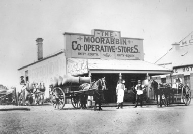 City of Kingston
Photograph - Digital image, Black and white, Moorabbin Co-operative Store, c. 1910
Black and white image depicting two men wearing aprons standing in front of Moorabbin Co-operative Stores, Nepean Highway Cheltenham. Exchange Hotel to the right. Three horse drawn wagons, on the left two white horses with a man holding the reins, one carrying a load with hessian sacks and another on the far right with a man in the seat of the wagon also wearing an apron, suggesting they are workers at the store.Black and white image of two men wearing aprons standing in front of Moorabbin Co-operative Store with three horse drawn wagons, on the left two white horses with a man holding the reins, one carrying a load with hessian sacks and another on the far right with a man in the seat of the wagon also wearing an apron. A sign on the left hand side of the building Havelock Tabacco.Printed in black text a round white sticker: 75 Hand written in red ink: 75%horse drawn wagon, workers, moorabbin, cheltenham, commerce, trade -
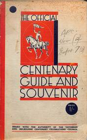 Melbourne Tram Museum
Book, Victorian and Melbourne Centenary Celebrations Council, "The Official Centenary Guide and Souvenir", 1934
Produced by the Victorian and Melbourne Centenary Celebrations 1934-1935. An extensive four month event was planned. Includes a short section of the history of Victoria and Melbourne, Education, Religious Activities, Public Utilities, Primary production, places of interest, Instructions, Pleasure Resorts and Sporting. The Utilities included the Victorian Railways, MMTB, Police, Melbourne Harbour Trust and the SEC. Includes many advertisements for car dealers, manufacturers, insurance and hotels.Yields information about the Melbourne Centenary Celebrations in 1934.Book - 222 pages - 7 sections, glued cover with many black and white photos and advertisements.Has pencil marks on the front and inside front cover and in marks on the outside rear cover.victoria, centenary celebrations, melbourne, mmtb, vr, secv, harbour trust -
 Ballarat Tramway Museum
Photograph - Ballarat tram 18 - Lake View, Ken Winney, 12/1949
The photograph shows SEC Ballarat tram No. 18 in Wendouree Parade at a location opposite the View Point Hotel. The "gazebo" at this location can be seen behind the tram. The tram has the destination of View Point and an auxiliary sign of "Lake View Point Only - connect with launches". On the left side of the photo is a highway advisory sign "Motorists Drive Slowly" Photo by I K Winney of Sydney, 12/1949.Yields information about tram 18 and the Lake View route.Black and white photograph with photographers details on rear."No. 18 at View Point terminus, note supplementary sing re ferry connection across Lake Wendouree, Ballarat, 12/1949, I K Winney"tramcars, tram 18, wendouree parade, lake view, road signs -
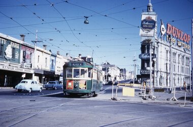 Melbourne Tram Museum
Slide - L 102 St Kilda Junction, Tramway Museum Society of Victoria (TMSV), mid 1960s
Colour slide of L 102, northbound, leaving High Street St Kilda at St Kilda Junction, running a route 4 service. The tram has adverts for Dutor valves and Booses engine oil additive. In the background are R T Taylor licensed grocer, Brookes Bros, the Junction Hotel advertising Rothmans, Dunlop tyres, and Wynvale Flagons. Some roadworks are taking place on the right-hand side.Yields information about St Kilda Junction and tram 102Kodachrome colour slides, cardboard mount, duplicate.Has "MP102" in pencil and stamped "Tramways Museum Society Victoria" on rear.tramways, l class, tram 102, st kilda junction, trams, route 4 -
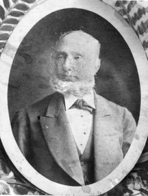 Stawell Historical Society Inc
Photograph, Mr George Jennings -- Studio Portrait
Portrait of George Jennings "Mayo Park" Lubeck. George Jennings was elected to Old Roads Board in 1863. Except for the years 1882 - 84. He served on the Council until 1891 - 1874 Shire President. From County Galway in Ireland. Jennings arrived in Pleasant Creek in 1858. For many years he owned "The Western Turf Hotel at Quartz Reefs. Selected land on the Ashens Run - settled there in 1870.Black and white photograph of a male in a oval setting with decoration in corners making a rectangle. Photograph in brown folder. The male is dressed in a suit, tie at neck of shirt, short hair and with a beard. Also an enlargement of studio photograph.George Jennings Mayo Park Lubeck written in biro.lubeck stawell shire president -
 Rutherglen Historical Society
Photograph - Image, W.H. Skey, 1938
T. Ready Gates erected by Roy Ready, son of T. Ready. The gates were removed in the late 1950s. After being missing for some years, the gates were located in the Council depot, refurbished by Ian Stones, and in 2017 were placed on display in the Museum.Black and White photo of Memorial Gates that were once the Murray Street entrance to the Rutherglen Park. The plaque on the gate dedicates them to the Pioneers of Rutherglen.On back of photo: "Entrance to Park, behind Rutherglen Hotel" On separate document: "This Plaque was attached to the Memorial Gates which were at the Murray St Entrance to the Rutherglen Park. The Gates were created in Memory of the Pioneers of the Rutherglen District. To Date it is not known when the Gates were erected buy they were removed in the early 1950s"rutherglen park, rutherglen memorial park, rutherglen pioneers, memorial gates -
 Ballarat Tramway Museum
Slide - 35mm slide/s set of 7, Noel Simons, 1972
Set of 7 transparencies undated on PAKON mounts - appear to be early 1970's. 1212.1 - No. 18 about to enter the Long Gully loop with ESSO service station on the right hand side. 1212.2 - No. 6 in Mitchell Street bound for Charing Cross. Tram has destination of "Rly Station". Has buildings on the east side of Mitchell St. in the background. 1212.3 - No. 7 (North Bendigo) and 29 (Golden Square) crossing. Actual location? 1212.4 - "No 6 showing 'SPECIAL' at Eaglehawk terminus. Has the Foodland store and Fruit shop in the background. 1212.5 - No. 19 at Eaglehawk terminus, on the extension to the normal Eaglehawk terminus. Tram has showing 'Eaglehawk'. Tram has two SEC roof ads. 1212.6 - No. 25 and another Bogie car at Quarry Hill terminus on last day. 1212.7 - No. 18 and 29 at Quarry Hill terminus. No.. 18 showing 'Quarry Hill' - has two SEC roof ads 'Electric Cooking - Matchless' and 'Everything's fine in my all electric kitchen' and No. 29 has a briquettes roof ad.Information typed onto a white label stuck on the slide. 1212.1 - "No. 18 at Long Gully" 1212.2 - "No. 6 in Mitchell Street." 1212.3 - "7 and 29 Lake View Hotel" 1212.4 - "No. 6 at Eaglehawk" 1212.5 - "No. 19 at Eaglehawk Term." 1212.6 - "Last cars Quarry Hill." 1212.7 - "18 & 29 Quarry Hill"tramways, trams, bendigo, long gully, mitchell st., eaglehawk, quarry hill, last tram, tram 6, tram 7, tram 18, tram 19, tram 25, tram 29 -
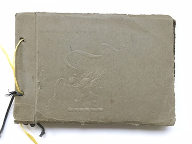 Warrnambool and District Historical Society Inc.
Book, Scrap Book, Circa 1930
This album contains photographs of many local and beach scenes such as view over Warrnambool, Botanic Gardens, Hopkins River and Bridge, Warrnambool railway station, Proudfoots, Thunder Point, Christ Church and the War Memorial. There are a couple of photographs of groups of people picnicking on the main beach. The newspaper cutting showing firemen dousing the last of the flames of the fire has onlookers including four children in the foreground. The Ozone Coffee Palace was built in 1890-1891 and burnt down February23, 1929. It was one of the largest fires in Warrnambool It was designed by Mr J McLeod. It was grand in design and decoration. The term Coffee Palace was used to describe temperance hotels which were built during the 1880’s -1890’s. They typically were multi-purpose and had a large number of rooms for ballrooms and leisure activities. Coffee palaces were aimed at families in coastal areas and inner city locations. Examples of some are The Windsor Hotel Melbourne, Ozone, Queenscliff and Kilbreda Convent in Mentone. This album has social and historical significance as it shows a collection of local scenes which is a record of familiar scenes such as the gardens, Hopkins River and beach scenes. The groups of people are unknown but the images provide a snapshot of customs and costumes of the early 1920’s.Khaki coloured soft card tied with a dark green cord which has broken and has been replaced with yellow string. There is an embossing of a lion/dragon on front cover with ribbons. 20 pages with photographs glued to most. A cutting relating to the fire at the Ozone mansions is inside the front cover.warrnambool history, early warrnambool photographs, ozone coffee palace -
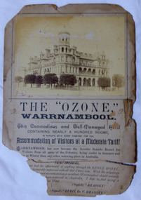 Warrnambool and District Historical Society Inc.
Poster - Warrnambool Ozone Hotel Poster, Circa 1895
The Ozone Coffee Palace was built in 1890-1891. It was designed by Mr J McLeod. It was grand in design and decoration. The term Coffee Palace was used to describe temperance hotels which were built during the 1880’s -1890’s. They typically were multi-purpose and had a large number of rooms for ballrooms and leisure activities. Coffee palaces were aimed at families in coastal areas and inner city locations. Examples of some are The Windsor Hotel Melbourne, Ozone, Queenscliff and Kilbreda Convent in Mentone. The bottom part of the advertisement is a testimonial written by Brassey and Sybil De V Brassey, Lord Brassey being Governor of Victoria around 1895. Their visit to Warrnambool and their stay at the Ozone sparked a much needed interest in the Ozone. In 1896 the price to stay at the Ozone was two pounds two shillings and it remain in business for several years but in 1910 it closed after losing money for many years. It remained closed until it was bought by Mr Howard Lawson in 1920. It continued to struggle financially. It was burnt down in February 1929. When the Ozone was built in1891 it was the largest building in Warrnambool. It occupied a prominent position on the corner of Koroit and Kepler Streets. The grand architectural style in which it was built, was used for a number of similar buildings throughout the state. The fire which destroyed the building was one of the largest in the town.Large photograph glued to the top of the card with text in various styles underneath. Photo is sepia and card is cream. The bottom part of the piece has broken away. Jordan in bottom LH corner of photograph. “L.N. Moore 2 Landcox St Nth Brighton” written in pencil on back. warrnambool, ozone coffee palace warrnambool, mansions hotel, hotel warrnambool, ozone fire 1929 -
 Eltham District Historical Society Inc
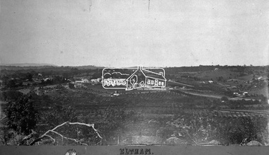
Negative - Photograph, Eltham, Vic, c.1890
View looking northeast from present day Ely Street (near intersection of present day Cronus Court and Porter Street) across what will become the site of Eltham High School towards Main Road showing the Eltham Courthouse and Police station. View is very similar to the sketch of Eltham published in 'The Illustrated Australasian News', December 26, 1884, p212. Note the large bluestone cell block behind police house and stable. George Knapman's Shoeing Forge next to the courthouse and the concentration of buildings around the Evelyn Hotel and Watson's Eltham Hotel on opposite sides of Main Road at Pitt street. Also note George Stebbing's cottage (c.1860) on Pitt Street behind the courthouse and 'Sunnyside' (home of W.J. Taylor built c.1885) at the top of the hill on Bible Street. In the foreground are orchards running up to the main street, Maria Street and also between Brougham Street and Dalton Street bordered by Bible Street.This photo forms part of a collection of photographs gathered by the Shire of Eltham for their centenary project book,"Pioneers and Painters: 100 years of the Shire of Eltham" by Alan Marshall (1971). The collection of over 500 images is held in partnership between Eltham District Historical Society and Yarra Plenty Regional Library (Eltham Library) and is now formally known as the 'The Shire of Eltham Pioneers Photograph Collection.' It is significant in being the first community sourced collection representing the places and people of the Shire's first one hundred years.Digital image 4 x 5 inch B&W Negshire of eltham pioneers photograph collection, eltham, 1890, bible street, brougham steet, dalton street, eltham courthouse, eltham hotel, evelyn hotel, franklin street, grant house, knapmans forge, main road, maria street, orchards, police residence, police station, pre 1900, stebbing cottage, sunnyside, w.b. andrew corn store, watsons hotel, little eltham -
 Mortlake and District Historical Society
Mt. Shadwell Bush Inn, photograph
This Mount Shadwell Bush Inn erected in 1854 was situated adjacent to one of the main routes to the diggings (Great Western Road), and was originally built from tufa stone obtained from a local quarry. It did a great trade after if first became licensed ub 1855, when it provided a valuable service to the travelling public and to the increasing agricultural population of the area. At that time it contained three sitting rooms, several large reception rooms, fourteen bedrooms, a bar and two taprooms and was the first known hostelry in Mortlake. In 1863 a bluestone addition (probably done by local architect Andrew Kerr) increased the size of the hotel to 23 rooms with a detached billiard room and ballroom, kitchen, servant's apartments, laundry, storeroom, 12 stalled stable, out office, and stock yards for travelling cattle. The present hotel with its 1928 rendered facade, has had an almost uninterrupted licence since 1855 -
 Ballarat Tramway Museum
Photograph - Digital image, W. J. Llewelyn, 6/03/1954 12:00:00 AM
Yields information about the Royal Visit to Ballarat and the tram decorated for its visit along with other arrangements.Set of three eight digital images taken of Queen Elizabeth II to Ballarat 6/3/1954 by W. J. Llewelyn. .1 - Street view of Sturt St looking East at St Patrick's church, with No. 38 in the background and the wooden crowd control barriers stacked by the footpath. .2 - Crowd waiting at the intersection of Sturt and Lydiard St. .3 - Crowd waiting in Sturt St, with soldier's, outside Myers Store .4 - Crowd and guard of honour waiting at the station. .5 - The Queen and Duke in the official car in Sturt St. .6 - ditto with Myer Store in the background. .7 - Scottish unit marching at the intersection of Bridge St and Grenville St with he Bucks Head Hotel in the background. Note the sign on the hotel pointing to the Floral Carpet at the Alfred Hall. .8 - Band at the City Oval. Date obtained from http://wiki.prov.vic.gov.au/index.php/Royal_Visit_1954,_Locations_for_Visiting_Municipalities,_Ballarat (accessed 11-6-2017)trams, tramways, civic functions, royal visit, railway station, lydiard st, sturt st, city oval, myers, tram 38 -
 Ballarat Tramway Museum
Slide - 35mm slide/s - set of 11, Eldon Hogan, mid 1960's to early 1970's
Set of 11 Agfa Plastic mounted slides - from the Eldon Hogan collection - possibly on an ARE Bendigo tours late 1960's or early 1970's with No. 18 Scanned on the Canon scanner at the depot 15/12/1971 at the time of the installation of the scanner. .1 - No 18 at Golden Square terminus with Billy Rodda's Golden Square Hotel in the background. .2 - ditto and the Victoria Bitter fence alongside the hotel. .3 - ditto and another single trucker. .4 - No. 18 at the Fire Station Loop, Golden Square line, with destination of Railway Station. .5 - No. 18 passing the Central Deborah mine, Violet St. Tram has a Briquette advertisement on the roof - the flaming briquettes. .6 - Another bogie tram at ditto. .7 - No. 18 and No. 6 crossing McCrae St loop near the depot junction? .8 - ditto .9 - No. 18 and a single trucker at the North Bendigo terminus. .10 - ditto .11 - with the single trucker leaving.tramways, trams, bendigo, golden square, central deborah, north bendigo, mccrae st, tram 18, tram 6 -
 Melbourne Tram Museum
Slide - Set of 5, Keith Caldwell, 1/11/1978 12:00:00 AM
Set of five Kodak Colour slides, cardboard mounts, by Keith Caldwell of: .1 - Z59 (East Brunswick, route 96) and Z41 (City route 88) in the Bourke St Mall, with the Buckleys and Myers buildings in the background. Dated 1.11.78. .2 - Z63 (East Brunswick route 96) and another Z at Swanston St in Bourke St with the Foys in the background. Also signs for Portmans, get smart clothing, Dated 1.11.1978. .3 - Z71 (City - Route 96) and another Z at the Spencer St stop, with the Eliza Tinsley building in the background. Dated 1.11.1978. .4 - Z71 (East Preston - Bell St - Route 89) and Z51 (East Preston Tyler St route 89) in Bourke St Mall, with Myers and the Post Office in the background. Dated 2.11.1978. .5 - Night photo of Z69, East Preston, at the Swanston St intersection? Has an illuminated sign for The Carlyon Hotel and South Cross Hotel in the backgroundDates as shown above in red ink.trams, tramways, bourke st, swanston st, z class, route 96, route 88, east brunswick, east preston, route 89, night photo, tram 59, tram 41, tram 63, tram 71, tram 69, tram 51 -
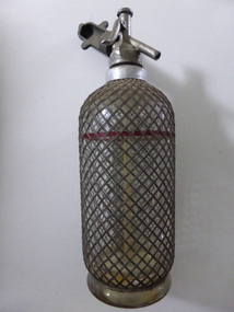 Warrnambool and District Historical Society Inc.
Bottle, Soda Siphon, c. 1920
This soda syphon is a device for dispensing carbonated or soda water. It was also called a Seltzer bottle. The design of soda syphons used in the 20th century was first created in the late 1830s and these bottles were especially popular in the 1920s and 30s. This Sparklets Company syphon was probably made in England but the company was manufacturing also in U.S.A. and Europe. This syphon has no known provenance but it could have been used in a hotel or a cordial factory in Warrnambool or district. This soda syphon is of interest as an example of how soft drinks were dispensed 90 to 100 years ago. It will be useful for display.This is a heavy glass bottle with a heavy base. It has a metal mesh over the bottle with a metal (or material) red band around the bottle three-quarters of the way up from the bottom. The mechanisms for filling and siphoning at the top are made of metal (these include a funnel and two handles). Attached to the top and inside the bottle is a tube for syphoning. Directions for use are printed on the lid. ‘Sparklets’ ‘Admit gas slowly and shake vigorously’ Important. Do not fill the bottle above the red line’. sparklets company, soda syphon bottle, warrnambool -
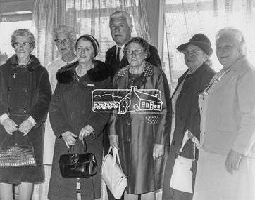 Eltham District Historical Society Inc
Photograph, His Excellency Major General Sir Rohan Delacombe with Lady members of the Shire of Eltham Elderly Citizens' Clubs, 19 September 1973
The State Governor Sir Rohan Delacombe and Lady Delacombe visited the Shire of Eltham where they were entertained to a civic luncheon by the Shire President Cr. L. E. Clarke and councilors at the Panton Hill hotel and made a tour of the shire. Among which was the Eltham elderly citizens' club where he met L-R: Mrs Lander, Mrs Stevenson, Mrs Armstrong, Mrs Norman, Mrs - , and Mrs Crockett. This photo forms part of a collection of photographs gathered by the Shire of Eltham for their centenary project book,"Pioneers and Painters: 100 years of the Shire of Eltham" by Alan Marshall (1971). The collection of over 500 images is held in partnership between Eltham District Historical Society and Yarra Plenty Regional Library (Eltham Library) and is now formally known as 'The Shire of Eltham Pioneers Photograph Collection.' It is significant in being the first community sourced collection representing the places and people of the Shire's first one hundred years.Digital imagemajor general sir rohan delacombe, mrs armstrong, mrs crockett, mrs lander, mrs norman, mrs stevenson, sepp, shire of eltham pioneers photograph collection, rohan delacombe, governor, visit, crockett, lander, sepp, senior citizens centre, seniors, older people, older women, stevenson, armstrong, shire of eltham pioneers photograph collection -
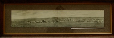
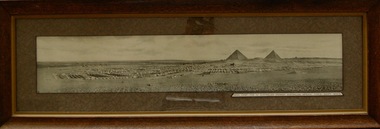 Lara RSL Sub Branch
Photograph, Mena Camp Egypt 1914-15
The Mena Camp, Egypt, was the training camp for the 1st Australian Imperial Forces(AIF) before the Landing at Gallipoli. The camp was located 16Kms from Cairo.Built around Mena House, it was a luxury hotel built next to the Pyramids of Giza (originally spelt Gizeh) supplied with its own purpose built tram-line to Cairo. The centre road up the middle of the camp was known as Artillery Road. The initial force consisted of 20,000 men.The Camp was a major training facility for the 1st Australian Imperial Force in 1014-15.Rectangular shaped glass covered picture frame showing a photo of Mena Camp-1914/15.Mena Camp-1st Australian Division. Australian Imperial Force-Egypt. 1914-15.mena camp, egypt, gallipoli, cairo, lara r.s.l. training camps, australian imperial force. -
 Lara RSL Sub Branch
Photograph, Mena Camp Egypt 1914-15
The Mena Camp, Egypt, was the training camp for the 1st Australian Imperial Forces(AIF) before the Landing at Gallipoli. The camp was located 16Kms from Cairo.Built around Mena House, it was a luxury hotel built next to the Pyramids of Giza (originally spelt Gizeh) supplied with its own purpose built tram-line to Cairo. The centre road up the middle of the camp was known as Artillery Road. The initial force consisted of 20,000 men.The Camp was a major training facility for the 1st Australian Imperial Force in 1014-15.Rectangular shaped glass covered picture frame showing a photo of Mena Camp-1914/15.Mena Camp-1st Australian Division. Australian Imperial Force-Egypt. 1914-15.mena camp, egypt, gallipoli, cairo, lara r.s.l. training camps, australian imperial force.