Showing 6760 items matching " rivers"
-
 Stawell Historical Society Inc
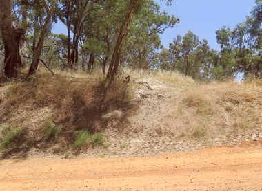
Photograph, Dunmunkle Creek where it originally connected to Wimmera River 2017 -- Coloured
Colour Photo of Dunmunkle Creek originally connected to Wimmera River at this point. Just before the Glenorchy Weir. 2017Colour photograph of what looks to be a dry creek bed. Timber on creek bank. Dunmunkle Creek originally connected to Wimmera River at this point. Just before the Glenorchy Weir (Photo taken 2017) water -
 Orbost & District Historical Society
black and white photograph, 1884?
James Alexander Robertson was born 14th June, 1855, at Pentridge. the Coburg area which was known as Pentridge at the time, and prior to the building of the gaol. His parents were James Thomson Robertson and Esther (nee Hale), At age 20 James became the first selector on the Snowy River at Lochend. He took up Lots 1, 2 and 3, in the Parish of Newmerella in 1875; with his selection being ratified on May 1st, 1876. The selection included hill and river flat land in the area near where Icy Creek enters the Snowy River. James gradually improved and farmed the property; he cleared and drained Icy Creek and constructed the first known flood-gate on the Snowy River. To meet his farming commitments he supplemented his income by working on the construction and maintenance of roads and drains in the Newmerella area. He gained a contract with the Bairnsdale Shire council to construct the first road cutting down Burn’s Hill at Newmerella. His tender was for £16 ($32), and it took him, with four others, two months to complete the contract. He was single, and, after his untimely death at aged 29, in 1884, his parents and surviving unmarried sisters and brothers moved from Sarsfield to take over his selection at Lochend. (more information Newsletter April 2013)James Robertson was the first selector of land at Lochend, Orbost.A small black / white portrait photograph, oval shaped with a white background. It is of a middle-aged man with a full beard and moustache.on front at bottom - typed in black -:"James Alexander Robertson, Late of Lochend, Snowy River"robertson-james-alexander lochend-robertson -
 Orbost & District Historical Society
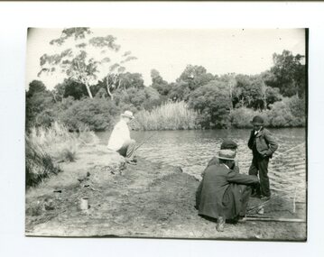
black and white photograph, late 19th - early 20th century?
This photograph shows men fishing in the Snowy River at Marlo - possibly at Bream Point. The man in the white coat is Lancelot Herbert. Lancelot Herbert came to Orbost in 1886, taking up a partnership with local store-owner George Temple. After Mr Temple’s death in 1891, Lancelot took over the store and progressively developed Herberts Snowy River Stores which grew into a department store of several shops along Nicholson St. He also had small shops at Cann River, Noorinbee and Genoa which were run by members of his family, as well as a carrying business and fuel outlets. Lancelot died on 2/6/1911 and his wife Martha [died 1945] are buried in a joint grave in Orbost Cemetery. (info. Noreen and Lindsay Thomson. More from "In Times Gone By' by Deborah Hall)This item is associated with the Herbert family very early settlers in the Orbost district. It is also associated with Marlo which has always been a popular fishing destinationA small black / white photograph of four men fishing from a river bank. Three are sitting and one is standing.on back - Lancelot Herbert in white coat fishingfishing-marlo herbert-lancelot -
 Marysville & District Historical Society
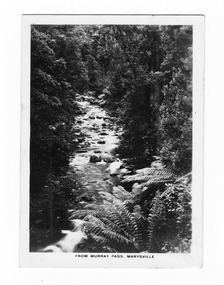
Photograph (item) - Black and white photograph, Rose Stereograph Company, From Murray Pass, Marysville, 1913-1967
An early black and white photograph of the Taggerty River from Murray Pass near Marysville, Victoria.An early black and white photograph of the Taggerty River from Murray Pass near Marysville, Victoria. Murray Pass is off the Lady Talbot Drive. Lady Talbot Drive a 24 kilometer scenic rainforest car journey which passes a number of walks and waterfalls in the Yarra Ranges National Park. Lady Talbot Drive is named after Lady Sarah Elizabeth, the wife of Sir Reginald Talbot, who was the Governor of Victoria from 25th April, 1904 to 6th July 1908.The photograph was also used to produce the Rose Series postcard P. 2309.marysville, victoria, photograph, taggerty river, murray pass, lady talbot forest drive, p. 2309, rose series postcard, souvenir, rose stereograph company, sir reginald talbot, lady sarah elizabeth talbot -
 Marysville & District Historical Society
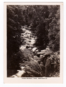
Photograph (item) - Black and white photograph, Rose Stereograph Company, From Murray Pass, Marysville, 1913-1967
An early black and white photograph of the Taggerty River from Murray Pass near Marysville, Victoria.An early black and white photograph of the Taggerty River from Murray Pass near Marysville, Victoria. Murray Pass is off the Lady Talbot Drive. Lady Talbot Drive a 24 kilometer scenic rainforest car journey which passes a number of walks and waterfalls in the Yarra Ranges National Park. Lady Talbot Drive is named after Lady Sarah Elizabeth, the wife of Sir Reginald Talbot, who was the Governor of Victoria from 25th April, 1904 to 6th July 1908.The photograph was also used to produce the Rose Series postcard P. 2309.marysville, victoria, photograph, taggerty river, murray pass, lady talbot forest drive, p. 2309, rose series postcard, souvenir, rose stereograph company, sir reginald talbot, lady sarah elizabeth talbot -
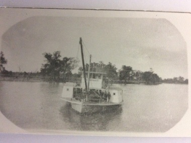 Port of Echuca
Black and white photograph, 1907
The P.S Canally was built in 1907 by R.W. Beer. Known as the "Greyhound of the River" after her original engine was substituted with a Railway locomotive, minus the wheels.The speed of the Canally set up tremendous wash, which sank any small craft. In 1929 it was sold to N. Collins who converted it to a barge. The Chislett Brothers were the owners when the P.S Canally sank at Boundary Bend in 1962. (Ref . Parsons R. "Ships of the Inland Rivers." P.58.)The P.S.Canally is significant because it was fitted with a locomotive, minus the wheels. This is significant because it shows the need for the paddle steamers to travel fast. This could show the competitiveness of the paddle steamer trade on the river in the early 20th Century. A small black and white photograph of an old photograph of the P.S Canally in the middle of the river. The paddle steamer is travelling towards the camera. p.s canally, beer, r.w., chislett brothers, collins, n. -
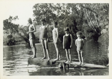 Kew Historical Society Inc
Photograph - Children on a diving platform on the Yarra at Kew, 1940s
The River Yarra was a traditional place of recreation for children and adults in Kew. Often swimming in the Yarra was made from platforms attached to the bank such as this one.Original black and white photograph. Group of five children in bathing costumes on a rudimentary diving board attached to the bank of the River Yarra.Reverse: "M Holmes"river yarra, recreation --- swimming -
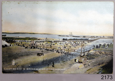 Flagstaff Hill Maritime Museum and Village
Postcard - Coastal Scene, Joseph Jordan, Sandy beach & breakwater Warrnambool, 1910
The coloured postcard depicts the Port of Warrnambool in the early 1900s. It shows the Breakwater, completed in 1890, the Viaduct, and the Merri River footbridge. There are many people on the sandy river banks, beach and bridge, and some are on the rocks of Middle Island. The printed postcard was made in England and is one of the Jordan Series produced by Joseph Jordan, a renowned photographer in Victoria's Western District.The postcard is locally significant as a record of the early footbridge over the Merri River, and the Viaduct before the space between the pylons was filled it. It shows the use of horses as a means of transportation. The photograph is also associated with Joseph Jordan, a renowned Victoria's Western District photographer.Postcard, coloured, showing the Port of Warrnambool. People are gathered on the sandy beach beside the river and near the river mouth. They are on and below the footbridge, along with several horses. Some are on the rocky Middle Island. There is a white ship in port. There is a jetty on the left, and buildings at the start of the breakwater. An inscription is printed at the bottom of the picture. The picture is one of the Jordan Series. It was printed in England in 1910."SANDY BEACH & BREAKWATER AT WARRNAMBOOL" "JORDAN SERIES" "PRINTED IN ENGLAND" "1910"warrnambool, shipwreck coast, flagstaff hill, flagstaff hill maritime museum, flagstaff hill maritime village, postcard, merri river, footbridge, warrnambool breakwater, breakwater, viaduct, middle island, port of warrnambool, jordan series, printed in england, 1910, joseph jordan, jordan photography -
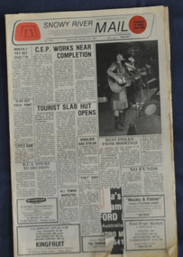 Orbost & District Historical Society
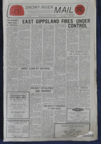
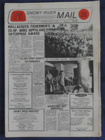
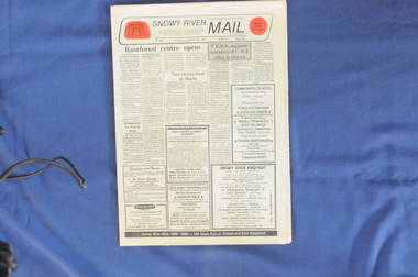
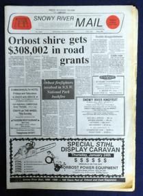
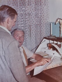
newspapers, Snowy River Mail, 1987
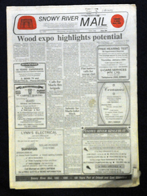
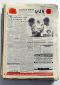
The Snowy River Mail is a weekly newspaper published in Orbost in the Shire of East Gippsland, Victoria, Australia. Previously published as The Snowy River mail and Tambo and Croajingolong gazette from 1890 to 1911. The Gippsland Courier merged with the Snowy River Mail when proprietor Lachlan Ross moved to Orbost in 1910. In 1999 the paper was acquired by the Yeates family when the Hollins family retired from the newspapers business. The paper is still being produced by the fourth generation of the Yeates family as part of East Gippsland Newspapers. These newspapers are useful research tools as they are contemporary records of events in Orbost.A cardboard box of black/white newspapers. There are 38 issues of the Snowy River Mail from 1987. All contain news reports, articles, photographs and advertisements.newspapers snowy-river-mail -
 Orbost & District Historical Society
newspapers, Snowy River Mail, 1988
The Snowy River Mail is a weekly newspaper published in Orbost in the Shire of East Gippsland, Victoria, Australia. Previously published as The Snowy River mail and Tambo and Croajingolong gazette from 1890 to 1911. The Gippsland Courier merged with the Snowy River Mail when proprietor Lachlan Ross moved to Orbost in 1910. In 1999 the paper was acquired by the Yeates family when the Hollins family retired from the newspapers business. The paper is still being produced by the fourth generation of the Yeates family as part of East Gippsland Newspapers. These newspapers are a useful reference tool as they contain contemporary reports of local events.A cardboard box of black/white newspapers. There are 32 issues of the Snowy River Mail from 1988. All contain news reports, articles, photographs and advertisements.newspapers snowy-river-mail -
 Orbost & District Historical Society
newspapers, Snowy River Mail, 1989
The Snowy River Mail is a weekly newspaper published in Orbost in the Shire of East Gippsland, Victoria, Australia. Previously published as The Snowy River mail and Tambo and Croajingolong gazette from 1890 to 1911. The Gippsland Courier merged with the Snowy River Mail when proprietor Lachlan Ross moved to Orbost in 1910. In 1999 the paper was acquired by the Yeates family when the Hollins family retired from the newspapers business. The paper is still being produced by the fourth generation of the Yeates family as part of East Gippsland Newspapers. These newspapers are a useful reference tool as they contain contemporary reports of local events.A cardboard box of black/white newspapers. There are 42 issues of the Snowy River Mail from 1989. All contain news reports, articles, photographs and advertisements.newspapers snowy-river-mail -
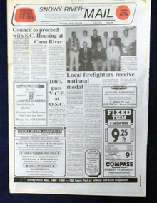
 Orbost & District Historical Society
newspapers, Snowy River Mail, 1990
The Snowy River Mail is a weekly newspaper published in Orbost in the Shire of East Gippsland, Victoria, Australia. Previously published as The Snowy River mail and Tambo and Croajingolong gazette from 1890 to 1911. The Gippsland Courier merged with the Snowy River Mail when proprietor Lachlan Ross moved to Orbost in 1910. In 1999 the paper was acquired by the Yeates family when the Hollins family retired from the newspapers business. The paper is still being produced by the fourth generation of the Yeates family as part of East Gippsland Newspapers. These newspapers are useful research materials as they are contemporary records of local eventsA cardboard box of black/white newspapers. There are 48 issues of the Snowy River Mail from 1990. All contain news reports, articles, photographs and advertisements.newspapers snowy-river-mail -
 Orbost & District Historical Society
newspapers, Snowy River Mail, 1991
The Snowy River Mail is a weekly newspaper published in Orbost in the Shire of East Gippsland, Victoria, Australia. Previously published as The Snowy River mail and Tambo and Croajingolong gazette from 1890 to 1911. The Gippsland Courier merged with the Snowy River Mail when proprietor Lachlan Ross moved to Orbost in 1910. In 1999 the paper was acquired by the Yeates family when the Hollins family retired from the newspapers business. The paper is still being produced by the fourth generation of the Yeates family as part of East Gippsland Newspapers These newspapers are useful reference tool as they contain contemporary records of local events.A cardboard box of black/white newspapers. There are 36 issues of the Snowy River Mail from 1991. All contain news reports, articles, photographs and advertisements.newspaper snowy-river-mail -
 Orbost & District Historical Society
newspapers, Snowy River Mail, 1992
The Snowy River Mail is a weekly newspaper published in Orbost in the Shire of East Gippsland, Victoria, Australia. Previously published as The Snowy River mail and Tambo and Croajingolong gazette from 1890 to 1911. The Gippsland Courier merged with the Snowy River Mail when proprietor Lachlan Ross moved to Orbost in 1910. In 1999 the paper was acquired by the Yeates family when the Hollins family retired from the newspapers business. The paper is still being produced by the fourth generation of the Yeates family as part of East Gippsland Newspapers These newspapers are useful references as they contain contemporary records of local events.A cardboard box of black/white newspapers. There are 17 issues of the Snowy River Mail from 1992. All contain news reports, articles, photographs and advertisements.newspapers snowy-river-mail -
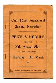 Orbost & District Historical Society
program, Snowy River Mail, 1927
Cann River is a town in the East Gippsland region of Victoria in Australia. The town is located on the Cann River at the junction of the Princess Highway and the Monaro Highway, in the Shire of East Gippsland. Before 1929 the original Cann River settlement was where Noorinbee now stands.Agricultural shows are an important part of cultural life in small country towns and these shows form an integral part of local history. This item reflects the significance of a volunteer group which no longer exists.A stapled paper program, orange with black print,"Cann River Agricultural Society, Noorinbee Prize Schedule for the 20th Annual Show to be held at Noorinbee on Thursday 10th March 1927" inside a rectangular black frame. -
 Orbost & District Historical Society
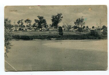
black and white photograph, Campbell. D.S, late 19th century ?
This is a photograph of the settlement of Orbost on the banks of the Snowy River,. In the foreground in the paddock there is a water trough (Bills?) and the B Drain can be seen on the far left. D.S. Campbell had a stationery store in Nicholson Street Orbost and published several black and white postcards of Orbost.This is a pictorial record o The township of Orbost in the late 19th century.A black / white photograph / postcard. There is a river in the foreground with houses and shops in the background behind a cleared paddock.on front - Orbostorbost-19th-century snowy-river -
 Orbost & District Historical Society
postcard, C1920-1940
This photograph shows the second major bridge across the Snowy River at Orbost. The current Snowy River bridge is the fourth to provide a crossing to the township of Orbost. The first, in 1891, lasted just two years before it succumbed to flood waters. The bridge in this photograph was built in the 1920s as a road and rail bridge, and was again partly washed away by flood waters in 1934. After the end of the first World War the Victorian Railways considered an extension of the railhead across the river at Orbost, and in 1922 a new timber and steel girder structure, a joint Country Roads Board — Victorian Railways venture, was built and completed at a cost of £41,000 (the steel girders came from the Flinders Street viaduct reconstruction). Subsequently it was decided not to take the railway across the river, and the bridge was only used by road traffic. It was severely battered by floods during its life. and after the 1971 floods was eventually replaced by the current bridge in 1975. (info from Newletter 54N by John Phillips) This item is an early pictorial record of the previous Snowy River bridge at Orbost.A postcard with a black / white photograph of a bridge - timber and steel girder structure - across the Snowy River at Orbost, Reflections of the bridge are seen in the water.snowy-river-bridge-orbost -
 Orbost & District Historical Society
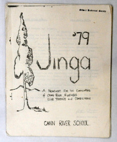
newsletter, Jinga, July 1979
Cann River is 75 km east of Orbost. The Cann River School newsletter is published fortnightly and includes a calendar of upcoming activities in the school and local community. When the newsletter started (probably in 1968) there was a discussion in the school as to what it would be called - Jinga eventually came out of that and it's still the same today. Jinga derived its name from Croajingolong. Croajingolong possibly comes from the Aboriginal words for 'belonging to' and 'east' and is the name of one of the five clans of the Kurnai (Gunni) - the Krauatungalung, who lived in this region. It is likely that the decision to go with 'Jinga' over 'Jingo' was made by popular vote. For a few years the school published a year magazine called Croalong, and now combines the two so the last issue of Jinga for the year is actually titled Croajingolong! (Information provided by Ruby, current editor of Jinga.) In small rural communities newsletters are an important communication medium. Cann River P-12 College has played a significant part in the education students in the Cann River district . It is the sole educational institution in Cann river. A newsletter for Cann River School. It contains black and white photographs, children's work and reports.newsletter-jinga cann-river -
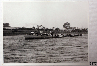 Flagstaff Hill Maritime Museum and Village
Photograph - Vessel, Steam Launch, Mrs. A. Dawson, Lady Loch, Feb 1907 - Jun 1910
The photograph shows the steam launch Lady Loch towing five rowing boats full of passengers on the Hopkins River at Warrnambool. The boat is travelling downstream from the riverbank near Jubilee Park towards Warrnambool and the river mouth. A similar trip in 1909 was a fund-raising excursion when the Lady Loch was to tow boats from Flett & Sons' boating establishment on the Hopkins River, travelling towards Jubilee Park. The photograph was taken between February 1907 and June 1910 by Mrs A. G. Dawson from the Hopkins River Bank at “Allandale”, which she was leasing. She took another photograph that day, which was published in the Warrnambool Standard on 24th March 1973. At the time of the photograph the launch Lady Loch was owned by James Flett & Son who operated a boatshed on the bend of the Hopkins River. The boat was described as “a fine little steamer”. In 1916 it was licenced to carry 42 passengers. The LADY LOCH: - In February 1884 Mr Sutton’s steam launch had the name of Lady of the Lake. The boat was part of the entertainment for a Sunday school picnic at Ballarat Lake and Gardens. In October 1884 Mr Ivey from Lake Wendouree purchased two vessels, the steamer Ballarat and Mr Sutton’s well-known and popular launch, Lady of the Lake, to join his own fleet of pleasure boats. In November 1887 Mr Mark Hooper’s purchase of a ‘new’ pleasure boat, Lady of the Lake, arrived in Colac to be an addition to his boating business. The launch had been transported by road from Ballarat, but the boiler and the engine had travelled by rail the previous day. In June 1888, Fanny Nelson purchased the steam launch Lady of the Lake for her Nelson’s Boating and Fishing Establishment on the Hopkins River, Warrnambool. She renamed it Lady Loch. People have suggested the mane was in honour of the wife of the then-current Governor of Victoria, Sir Henry Loch, and the local paper stated that Lady Loch flew the Governor’s colours of yellow, black and blue on her first trip under Nelson’s ownership, Sunday 12th August 1888. In 1890 Fanny Nelson sold her complete business, including Lady Loch, to Mr Chapman. in January 1897 James Flett & Sons, already involved in boating, purchased the business from Chapman. In January 1916, Flett advertised everything for sale, including the boatshed and the steam launch Lady Loch. NOTE: - at least three vessels in Victoria were named Lady Loch; a river launch (ca 1884-ca 1916), a steamer ferry (1884-1920s) and a government steam lighthouse tender HMS Lady Loch (1886-1962)The photograph of the Lady Loch pleasure steamer represents the social and recreational activities of late 19th-century people from Warrnambool and the local district. It shows an example of the pleasure craft of that era. The history of the Lady Loch includes the history of fishing and boat hire businesses of that period. The photograph is also connected with an early Warrnambool buat builder James Flett & Sons. representing the maritime history of the town.Photograph, black and white, of the steam launch Lady Loch towing five rowing boats downstream on the Hopkins River from Jubilee Park towards the river mouth. There are many figures on the boats. The photograph was taken from a property called Allandale on the south river bank between February 1907 and June 1910. The photographer was Mrs A. G. Dawson. The Lady Loch was owned by Mr James Flett & Sons at that time. The photograph is mounted on card.flagstaff hill, warrnambool, shipwrecked-coast, flagstaff-hill, flagstaff-hill-maritime-museum, maritime-museum, shipwreck-coast, flagstaff-hill-maritime-village, lady of the lake, lady of the lake steamer, lady loch steamer, lake colac steamer, hopkins river warrnambool, jubilee park warrnambool, francis maria mann, andrew abernathy nelson iiird, hopkins hotel, nelson's boathouse, chapman's boathouse, flett's boathouse, fanny (francis) nelson, james flett & sons -
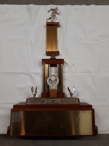 Vision Australia
Photograph - Image, River Run Female Winner trophy
A race along the banks of the Yarra River (?) this trophy was awarded to the female winners from 1978-1987. A golden running figure sits atop a pedestal that rests on a bell located above two pedestals behind a golden laurel wreath. Two eagles, with wings outstretched as if just landing, are either side of the wreath and the inscription 'Rotary Club of Glenferrie - River Run - Female winner - Donated by Bob Bruner' is written on the plinth below them. On the base plinth are inscribed the names of the previous winners: 1978 Lynne Williams 1979 Lynne Williams 1980 Lynne Williams 1981 Dorothy Browne 1982 Dorothy Browne 1983 Michelle Baumgarten 1984 Laura Dess 1985 Mary Edwards 1986 Julie McKie 1987 Julie McKieGold running figure atop two levels of columns with a wreath and two eagles at the base, whereupon names are inscribedRotary Club of Glenferrie River Run Female Winner Donated by Bob Brunerassociation for the blind, awards -
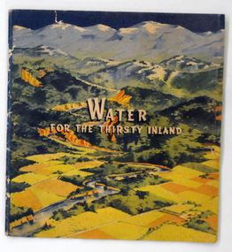 Orbost & District Historical Society
book, Water For the Thirsty Inland, 1945
Water For the Thirsty Inland was published by The Murrumbidgee Valley Water Users Association as a case for diversion of part of the Snowy River waters to the Murrumbidgee. In 1950 The Murrumbidgee Valley Water Users Association and the League established the Murray-Murrumbidgee Development Committee to ensure the Snowy Scheme was completed.This book is a significant research tool for the history of the diversion of the Snowy River.A 44 pp book, titled Water For The Thirsty Inland. On the front cover is a coloured print of a painting of a river (Snowy River?) from the mountains to the flats. The text of the title is white with a black shadow. The book contains b/w photographs and the print is black and green.Some pencilled notes on back.snowy-river murrumbidgee-valley-water-users' irrigation -
 Peterborough History Group
Newspaper articles pertaining to Peterborough from 1990 to 1999
Various newspaper articles kept by Mrs Dawn Irvine, all pertaining to Peterborough - river flooding and quality, concerns over council boundary realignment. Article titles: 6/10/1992 Flooding at Peterborough 28/6/1994 Residents undecided over River 4/7/1994 Letter from Warren Moore. Peterborough is alive, the way residents like it. 26/12/1994 Letter from R. Irvine. Apprehension over changes 17/6/1998 Algae fear prompts call to open Curdies River 13/4/1999 Battlelines on the Curdies 14/4/1999 Peterborough residents urge BHP to find alternative waste disposal optionHistoric overview of the towns' concerns at that time. Seven newspaper cuttings of various sizes all regarding aspects of Peterborough. Includes objection to BHP discharging waste into the Curdies River and flooding. warren moore, ronald irvine, curdies river, moyne council, council boundary realignment, curdies river flooding, floods, peterborough, blue green algae, river quality, bhp waste management, bhp -
 Marysville & District Historical Society
Photograph (item) - Black and white photograph, Unknown
An early black and white photograph of a man attempting to repair the tree bridge which once traversed the Steavenson River at the base of Steavenson Falls.An early black and white photograph of a man attempting to repair the tree bridge which once traversed the Steavenson River at the base of Steavenson Falls. The Steavenson Falls is named after the Victorian Assistant Commissioner of Roads and Bridges, John Steavenson who arrived in Victoria in the early 1860s.steavenson falls, steavenson river, marysville, victoria, waterfalls, john steavenson -
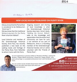 Greensborough Historical Society
Article - Newsletter Clipping, Colin Brooks, New Local History published on Plenty River, 2023
Article about Anne Paul's book, "Walking the Kurrum Yallock" regarding the walking tracks and heritage of the Plenty River, from Brooksy's BriefingPrinted article about book written by Anne Paul regarding th walking track and heritage of the Plenty River from Brooksy's Briefingplenty river, anne paul, greensborough historical society, colin brooks -
 Wodonga & District Historical Society Inc
Album - Ringer's River by Des Martin - Plate 32 - The shooting of Nugent
Advised of the tragedy by one of the stockmen Ellen O'Hara drives the gig towards Overton, but meets Klinberg who tells her the police have found a body near Nugent's place. Ellen gets there as Nugent is pulling Keiran's body from the river. Shock grief, and old bitternesses unhinge her mind. Seizing Trooper Ryan's pistol from on top of his clothes she shoots Nugent dead, and bolts up a rough back track towards her home with the police in pursuit. Her pony falls while belting along a narrow, dangerous piece of the track, and the gig goes over a cliff. Ellen is killed.The album and images are significant because they document literature written by a prominent member of the Wodonga community. The presentation of this precis was supported by several significant district families and individuals.Ringer's River Album Coloured photo Plate 32des martin, many a mile, ringer's river, northeast victoria stories -
 Port of Echuca
Black and white photograph, 21.09.1984
Black and white photograph of the P. S. Gem moored by the river bank. Recorded as being holed on Mildura slip. For statistical on the P. S. Gem see registration no.10 from The River trade, Wool & Steamers by G. Painter , pp.55, 66. Details of the paddle steamer can be located in The Register of Australian & N. Z. Shipping.The P. S. Gem is a large paddle steamer of historical and social significance. It has 3 levels including what appears to be many cabins.Black and white photograph of P. S. Gem moored by river bank. Recorded as being holed on Mildura slip. Copy of an original photograph taken 1954.On reverse of photo in pencil: Gem 1954, holed on Mildure slip.p. s. gem, mildura slip -
 Kew Historical Society Inc
Photograph - Mother and child at the Yarra River, Kew, 1950s
Canoeing on the River Yarra was a recreational traditional pastime for the people of Kew and Melbourne since settlement in the 1830s. Later in the century, canoes were frequently hired from boathouses.Print enlargement. Woman beside river holding a piece of string. Child swimming in Yarra. Canoe in distance beside bank with passengers.Reverse: "M Holmes"recreation -- canoeing, yarra river -- kew -
 Wodonga & District Historical Society Inc
Album - Ringer's River by Des Martin - Plate 12 - A positive result from the customs duty
Meantime back at Camoola "Top Or Nothing" Price, known to stockmen as "Old Stop At Nothing", and his shifty ex-jockey clerk Billy Matthews, have been stunned by the Victorian customs duty of 30 shillings per head on cattle, and 50 shillings per head on horses, suddenly promulgated just prior to a very important sale. Caught with a lot of cattle he cannot unload, and a property sale that has gone astray, Price accepts offers for both from O'Day, who thus sets himself up cheaply with a good holding that runs down Barmagulla's back boundary to the Murray River at the point where he often swims across.The album and images are significant because they document literature written by a prominent member of the Wodonga community. The presentation of this precis was supported by several significant district families and individuals.Ringer's River Album Coloured photo Plate 12des martin, many a mile, ringer's river, northeast victoria stories -
 Orbost & District Historical Society
newspapers, Snowy River Mail, 1993
The Snowy River Mail is a weekly newspaper published in Orbost in the Shire of East Gippsland, Victoria, Australia. Previously published as The Snowy River mail and Tambo and Croajingolong gazette from 1890 to 1911. The Gippsland Courier merged with the Snowy River Mail when proprietor Lachlan Ross moved to Orbost in 1910. In 1999 the paper was acquired by the Yeates family when the Hollins family retired from the newspapers business. The paper is still being produced by the fourth generation of the Yeates family as part of East Gippsland Newspapers. These newspapers are useful research tools as they contain contemporary accounts of local events.A cardboard box of black/white newspapers. There are 49 issues of the Snowy River Mail from 1993. All contain news reports, articles, photographs and advertisements as catalogue inserts.newspapers snowy-river-mail -
 Orbost & District Historical Society
newspapers, Snowy River Mail, 1994
The Snowy River Mail is a weekly newspaper published in Orbost in the Shire of East Gippsland, Victoria, Australia. Previously published as The Snowy River mail and Tambo and Croajingolong gazette from 1890 to 1911. The Gippsland Courier merged with the Snowy River Mail when proprietor Lachlan Ross moved to Orbost in 1910. In 1999 the paper was acquired by the Yeates family when the Hollins family retired from the newspapers business. The paper is still being produced by the fourth generation of the Yeates family as part of East Gippsland Newspapers These newspapers are useful research tools as they contain contemporary accounts of local events.A cardboard box of black/white newspapers. There are 49 issues of the Snowy River Mail from 1994. All contain news reports, articles, photographs and advertisements a catalogue inserts. newspapers snowy-river-mail