Showing 2848 items matching "white horse"
-
 Kiewa Valley Historical Society
Photo - Bogong Township, March 1944
In 1940 Field Headquarters for the Kiewa Scheme were established at Bogong with office, workshop facilities and accommodation for workmen, staff and some families constructed. (There had been a 'tent camp' on this site in 1939 but was destroyed by bushfires) Construction of accommodation continued until 1947. A total of 40 houses plus a hostel for single staff, post office, police station, medical centre and primary school all with water and sewerage and electricity supply. The staff hostel was known as Kiewa House and is now occupied by the Education Department. Lake Guy was named after Mr. L.T. Guy who was the Resident Engineer in charge of construction work and associated activities on the Kiewa area. He held this position from 1939 to November 1946 when he was transferred to Head Office. The Bogong Township was developed firstly as an accommodation centre (base camp) for construction workers employed under the Kiewa Hydroelectric Scheme. Due to the influx of European workers into the Township the beautification of the immediate surrounds (gardens etc.) had a distinct European flavour. This environment has been very beneficial for tourism in later years. At the completion of the scheme, in the 1960's, the village was opened to public/tourism use. Strict environmental control has not allowed for any extensive redevelopment in tourist accommodation and basically restricted it to the accommodation initially built for the construction workers. Activities such a bike riding, snow skiing, restricted horse riding and bush walking on the Alpine plains and mountains are now a viable part of the Kiewa Valley Tourist Industry. The lake is one of the many water storage reservoirs used to supply the power stations their main power to run the huge turbines generating the final product, electricityBlack and white photograph of Bogong Township taken March 1944Handwritten on the back of photo - Township March '44bogong village, secv -
 Kiewa Valley Historical Society
Postcard - Lake Guy and Bogong Village
In 1940 Field Headquarters for the Kiewa Scheme were established at Bogong with office, workshop facilities and accommodation for workmen, staff and some families constructed. (There had been a 'tent camp' on this site in 1939 but was destroyed by bushfires) Construction of accommodation continued until 1947. A total of 40 houses plus a hostel for single staff, post office, police station, medical centre and primary school all with water and sewerage and electricity supply. The staff hostel was known as Kiewa House and is now occupied by the Education Department. Lake Guy was named after Mr. L.T. Guy who was the Resident Engineer in charge of construction work and associated activities on the Kiewa area. He held this position from 1939 to November 1946 when he was transferred to Head Office. The Bogong Township was developed firstly as an accommodation centre (base camp) for construction workers employed under the Kiewa Hydroelectric Scheme. Due to the influx of European workers into the Township the beautification of the immediate surrounds (gardens etc.) had a distinct European flavour. This environment has been very beneficial for tourism in later years. At the completion of the scheme, in the 1960's, the village was opened to public/tourism use. Strict environmental control has not allowed for any extensive redevelopment in tourist accommodation and basically restricted it to the accommodation initially built for the construction workers. Activities such a bike riding, snow skiing, restricted horse riding and bush walking on the Alpine plains and mountains are now a viable part of the Kiewa Valley Tourist Industry. The lake is one of the many water storage reservoirs used to supply the power stations their main power to run the huge turbines generating the final product, electricityBlack and white photographic postcard of Lake Guy and Bogong Village. Kiewa Hydro electric Project (showing Junction Dam in front)Handwritten on the back of postcard ' Like most of our camps, this looks like something from the Canadian Rockies' Stamped on the back - Valentine's Post Card A genuine photographlake guy, bogong village, secv -
 Kiewa Valley Historical Society
Photo - Bogong Township, September 1953
In 1940 Field Headquarters for the Kiewa Scheme were established at Bogong with office, workshop facilities and accommodation for workmen, staff and some families constructed. (There had been a 'tent camp' on this site in 1939 but was destroyed by bushfires) Construction of accommodation continued until 1947. A total of 40 houses plus a hostel for single staff, post office, police station, medical centre and primary school all with water and sewerage and electricity supply. The staff hostel was known as Kiewa House and is now occupied by the Education Department. Lake Guy was named after Mr. L.T. Guy who was the Resident Engineer in charge of construction work and associated activities on the Kiewa area. He held this position from 1939 to November 1946 when he was transferred to Head Office. The Bogong Township was developed firstly as an accommodation centre (base camp) for construction workers employed under the Kiewa Hydroelectric Scheme. Due to the influx of European workers into the Township the beautification of the immediate surrounds (gardens etc.) had a distinct European flavour. This environment has been very beneficial for tourism in later years. At the completion of the scheme, in the 1960's, the village was opened to public/tourism use. Strict environmental control has not allowed for any extensive redevelopment in tourist accommodation and basically restricted it to the accommodation initially built for the construction workers. Activities such a bike riding, snow skiing, restricted horse riding and bush walking on the Alpine plains and mountains are now a viable part of the Kiewa Valley Tourist Industry. The lake is one of the many water storage reservoirs used to supply the power stations their main power to run the huge turbines generating the final product, electricityBlack and white photograph of Bogong Township taken from Little Arthur fire track. September 1953Faded handwritten inscription on back - Bogong Township taken from Little Arthur fire track. Sept 1953bogong village, secv -
 Kiewa Valley Historical Society
Photo - First Bogong Camp, September 1950
In 1940 Field Headquarters for the Kiewa Scheme were established at Bogong with office, workshop facilities and accommodation for workmen, staff and some families constructed. (There had been a 'tent camp' on this site in 1939 but was destroyed by bushfires) Construction of accommodation continued until 1947. A total of 40 houses plus a hostel for single staff, post office, police station, medical centre and primary school all with water and sewerage and electricity supply. The staff hostel was known as Kiewa House and is now occupied by the Education Department. Lake Guy was named after Mr. L.T. Guy who was the Resident Engineer in charge of construction work and associated activities on the Kiewa area. He held this position from 1939 to November 1946 when he was transferred to Head Office. The Bogong Township was developed firstly as an accommodation centre (base camp) for construction workers employed under the Kiewa Hydroelectric Scheme. Due to the influx of European workers into the Township the beautification of the immediate surrounds (gardens etc.) had a distinct European flavour. This environment has been very beneficial for tourism in later years. At the completion of the scheme, in the 1960's, the village was opened to public/tourism use. Strict environmental control has not allowed for any extensive redevelopment in tourist accommodation and basically restricted it to the accommodation initially built for the construction workers. Activities such a bike riding, snow skiing, restricted horse riding and bush walking on the Alpine plains and mountains are now a viable part of the Kiewa Valley Tourist Industry. The lake is one of the many water storage reservoirs used to supply the power stations their main power to run the huge turbines generating the final product, electricityBlack and white photo of Bogong Village. September 1950Handwritten on the back - 1st Bogong Camp. SEC Kiewa Scheme Sept 1950bogong camp, bogong village, secv -
 Kiewa Valley Historical Society
Photo - Bogong Village Township
In 1940 Field Headquarters for the Kiewa Scheme were established at Bogong with office, workshop facilities and accommodation for workmen, staff and some families constructed. (There had been a 'tent camp' on this site in 1939 but was destroyed by bushfires) Construction of accommodation continued until 1947. A total of 40 houses plus a hostel for single staff, post office, police station, medical centre and primary school all with water and sewerage and electricity supply. The staff hostel was known as Kiewa House and is now occupied by the Education Department. Lake Guy was named after Mr. L.T. Guy who was the Resident Engineer in charge of construction work and associated activities on the Kiewa area. He held this position from 1939 to November 1946 when he was transferred to Head Office. The Bogong Township was developed firstly as an accommodation centre (base camp) for construction workers employed under the Kiewa Hydroelectric Scheme. Due to the influx of European workers into the Township the beautification of the immediate surrounds (gardens etc.) had a distinct European flavour. This environment has been very beneficial for tourism in later years. At the completion of the scheme, in the 1960's, the village was opened to public/tourism use. Strict environmental control has not allowed for any extensive redevelopment in tourist accommodation and basically restricted it to the accommodation initially built for the construction workers. Activities such a bike riding, snow skiing, restricted horse riding and bush walking on the Alpine plains and mountains are now a viable part of the Kiewa Valley Tourist Industry. The lake is one of the many water storage reservoirs used to supply the power stations their main power to run the huge turbines generating the final product, electricityBlack and white photograph of Bogong Village from across Lake Guy. Photo mounted on buff cardbogong village, secv -
 Kiewa Valley Historical Society
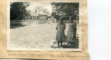
Photographs x 2- Khancoban Station and Comet the horse
In 1824, Hume and Hovell were the first Europeans to pass through the district and graziers soon followed, impressed by the abundance of fodder and water. The first cattle run in the area was settled in about 1838 in what was known as Swampy Plains. Later, this run became known as “Khancoban Station”. Khancoban lies in the heart of the high country and is home of Australia’s mountain cattlemen. This heritage is celebrated in Banjo Paterson’s epic poem, “The Man from Snowy River”. In 1962, Bruce and Jo Chisholm relocated from Bond Springs to Khancoban Station, which Bruce had acquired in 1959. Khancoban Hereford and thoroughbred stud progeny were keenly sought after whenever they were presented in the sale ring. Bruce imported a stallion, Comet, from England in 1964. Comet stood at Khancoban for 15 years and was the sire of numerous winners, including Cobbermine, Kelly's Eye, Boack and Starglow. Photographs demonstrate local Kiewa Valley residents enjoying a community visit to the historic homestead at Khancoban Station which holds significance to the early history of the area. Its heritage is celebrated in Banjo Paterson’s epic poem, “The Man from Snowy River”. Also demonstrates a pictorial history of social activities undertaken during this period Black and white photographs mounted on buff card 1. Kiewa Valley residents visiting Khancoban Station 2. Photo of thoroughbred horse Comet and handler at Khancoban Station1. Handwritten in black ink below photo- Khancoban Station. Mrs. Young, Mrs Van Der Weyde 2. Handwritten in black ink above photo- "Comet' at Khancobankiewa valley residents, clare roper -
 Kiewa Valley Historical Society
Photographs and copies of photographs of the pack horses and early horsemen who transported supplies to outposts in the Bogong High Plains, via cattle tracks before access roads were made
In the mid to late 1930’s survey outposts were established to plot the early stages of the Kiewa Hydro Electric System for the SECV in the Bogong High Plains. Before any roads were built, the old cattleman’s tracks were used with packhorses to deliver supplies, wages and mail and collect timesheets and correspondence from the workmen and dam builders living in canvas tents and at the outlying survey posts. The trip up the mountain was long and hard and dangerous for both horse and man Most of the men of the survey teams were not bush-men and were often ill equipped for the harsh weather and living conditions of bush camping, often arriving in their city clothes ready for work. The tent city at Bogong was destroyed by bush fires in 1939 after which an access road was built from Mt Beauty to transport building materials for more permanent dwellings for workmen. Pack horses continued to be used for transporting goods etc. to workers further up the mountain.Without the work of horsemen and their pack horses providing supplies and communications for outlying outposts, surveying and early planning for the Kiewa Valley Hydro Electric scheme could not have gone ahead and the dams and power stations which support the system could not have been constructed. The Hydro-electric scheme, and the workers who planned and built it play a major part in the early history of the Kiewa Valley and many original families still remain living, or have ties with the local area.: Set of 21 black and white photographs and copies of photographs depicting the pack horses and the men who handled them, transporting supplies and correspondence to the outlying camps and survey posts in the Bogong High Plains, via the rough cattlemen’s tracks. Photographs also show the early tent camps of the workers. Some photos mounted on A4 white paper. Some photos enlarged to A3 poster size for display1. Handwritten on back – Max Lawrence 2. -8 No inscriptions 9. Handwritten on back- Packing in supplies for early workers of the Kiewa Hydro scheme. There were no roads in the early days of the scheme 10. Printed on bottom of photo- Roper’s cattle on road below Howman’s Gap 11. Handwritten on back – Roper’s et al about to leave for the high plains 12. Printed under photo- Syd Ryder at the Pretty Valley Cut-Out (JBR) 13-16. No markings 17. Printed under photo- Gwen Talbot visits the Camp area. 1937 18. Handwritten on back- 14/1 Barbara Talbot 19. No markings 20-21. No markings 22. Printed under photo- STATE ELECTRICITY COMMISSION OF VICTORIA. Date: 15-3-45 Time: 8.0pm No: K 1838 Kiewa Hydro-Electric Works, Investigations 1944-1945 – Survey Camp at Young’s Hut pack horses; bogong high plains; survey posts; supplies delivery -
 Kiewa Valley Historical Society
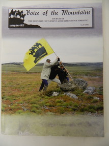
Journal - The Mountain Cattlemen's Association of Victoria - No. 29 (2006) x2, Voice of the Mountains, 2006
The High Plains Cattlemen's licenses expired in Aug. 2005 ending a 170 year history of alpine grazing in Victoria and Australia. This journal, No. 29, is published by the Mountain Cattlemen's Association "caring since 1835" and has articles and histories of the families and their activities. Many of the Mountain Cattlemen lived / live in the Kiewa Valley. This journal contains their history, activities and views.Stiff colored cardboard cover journal with title at the top of the cover. Consists of 56 pages. Centre 4 pages not numbered and are on yellow paper. Black and white photos are included.mountain cattlemen, bogong high plains, horses -
 Kiewa Valley Historical Society
Photograph – Set of 3 black and white photographs of Bogong Village circa late 1930's - 1940's during early construction of Lake Guy ( in the foreground), Late 1930's - 1940's
In 1940 Field Headquarters for the Kiewa Scheme were established at Bogong with office, workshop facilities and accommodation for workmen, staff and some families constructed. (There had been a 'tent camp' on this site in 1939 but was destroyed by bush fires) Construction of accommodation continued until 1947. A total of 40 houses plus a hostel for single staff, post office, police station, medical centre and primary school all with water and sewerage and electricity supply. The staff hostel was known as Kiewa House and is now occupied by the Education Department. Lake Guy was named after Mr. L.T. Guy who was the Resident Engineer in charge of construction work and associated activities on the Kiewa area. He held this position from 1939 to November 1946 when he was transferred to Head Office. The Bogong Township was developed firstly as an accommodation centre (base camp) for construction workers employed under the Kiewa Hydroelectric Scheme. Due to the influx of European workers into the Township the beautification of the immediate surrounds (gardens etc.) had a distinct European flavour. This environment has been very beneficial for tourism in later years. At the completion of the scheme, in the 1960's, the village was opened to public/tourism use. Strict environmental control has not allowed for any extensive redevelopment in tourist accommodation and basically restricted it to the accommodation initially built for the construction workers. Activities such a bike riding, snow skiing, restricted horse riding and bush walking on the Alpine plains and mountains are now a viable part of the Kiewa Valley Tourist Industry. The lake is one of the many water storage reservoirs used to supply the power stations their main power to run the huge turbines generating the final product, electricity3 black and white photographs of the Bogong camp area showing the clearing of trees for the construction of the Junction Dam and Lake Guy. Some administration buildings have been constructed, but part of the tent camp can be seen to the right of the photograph in front of the buildings. bogong village; junction dam; lake guy; kiewa hydro electric scheme; secv -
 Kiewa Valley Historical Society
Postcard Circa 1950, Road to Bogong High Plains Kiewa Hydro Electric Project, Circa 1950's
This postcard was produced in the 1950's for the tourist trade in the Kiewa Valley and Alpine region. It encompasses the period when the State of Victoria was pressured by the ever increasing demand by industry and its population for electricity supplies. Hydro electricity was seen as an untapped natural resource to quench this demand. The Victorian Alps and the rivers flowing into its valleys was ideal for the construction of the Kiewa Hydro Electricity Scheme. The late 1940's saw the development of this scheme and the changing of sections of alpine landscape is covered by this and other postcards/pictures (tourists, construction workers, and established rural populations). This period in time was before the established wildlife and forest/nature groups became political activist who changed legislative acts to protect the environment.This rural region (Kiewa Valley/alpine plains) was at most only significant to a smaller group of winter sports, summer hikers/horse riders and rural farmers/graziers. The numbers of tourists and the increase in the local resident population was boosted by the construction of the Hydro Electricity Scheme. This influx to the regional population resulted in a corresponding diversity in services and brought about an environment that responded to a growing level of tourists and thereby permitting this industry to grow more rapidly than it would have naturally. This postcard details an attraction to the "cleaner" method of providing electricity. This postcard was purchased in 1950 by a surveyor at Landford's Gap.This black and white photograph on a Valentine's postcard is from a V2 Argus photograph.. It is on a 200g/m paper density photo side gloss. See 0480 (A) - (G) for other photos of similar postcards.In white lettering " ROAD TO BOGONG HIGH PLAINS KIEWA HYDRO-ELECTRIC PROJECT", V3secv, road making, victorian alps -
 Kiewa Valley Historical Society
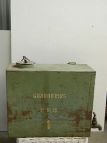
Water tank - Gundowring, 1923
The two Gundowring Fire Brigade tanks (20 - 30 litres) may have been used for drinking water for the fire fighters. Their curved side and handles indicate that they were attached (strapped) to horses or a round tank and transported to the fire. This tank was used for drinking water for the fire fighters of Gundowring during the 1923 fire. Some of their equipment was home made. The Gundowring Fire Brigade was a rural fire brigade operating in 1923.Green rusty metal rectangular box with 1 curved side. At the top is an outlet with a lip with a lid fitted in it. The life has a metal hollow lever attached to its middle and is inscribed. One end of the tank has a sturdy tap at the bottom. One side has a white painted inscription. On the opposite side attached near the opening is a hollow metal triangular piece to enable the tank to be strapped onto transport. and also on the opposite side at the middle bottom a square hollow metal handle. this side is curved horizontally.Lid: "? sprayer" Side: "Gundowring R.F.B. -(Rural Fire Brigade)gundowring fire brigade. cfa. drinking water. water container. horses. tank. bush fire. -
 Warrnambool and District Historical Society Inc.
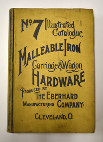
Book - Illustrated Catalogue of Malleable Iron Hardware, The Eberhard Manufacturing Company, No. 7 Illustrated Catalogue Malleable Iron Hardware, 1908
Catalogue from American company of malleable hardware itemsThis is a book of 732 pages. It has a yellow cloth cover with black printing and pages edged in red. The contents contain an index and pages of black and white sketches and text.non-fictionCatalogue from American company of malleable hardware itemscarriage and wagon hardware, eberhard manufacturing company -
 Warrnambool and District Historical Society Inc.
Plaque, Ranti
This is one of a series of plaques which commemorated some of the winners of the Grand Annual Steeplechase which is held each year in Warrnambool. It is the longest race at a public course in Australia.The first Grand Annual was held in 1872 as the Warrnambool Handicap Steeplechase. This series of plaques were painted by local artist Leslie Lamey and were originally in the members enclosure at the Warrnambool Racecourse. This plaque notes the win of horse Ranti but unfortunately we have no further details at this stage.These items relate to a significant part of Warrnambool's sporting and social history. Painted white rectangular tin plaque with rolled edges with painting of jockey's silks and cap. The silks are yellow sleeves with black bront and back. The cap is alternating yellow and black panels. with yellow brim.Ranti in red texta on back of plaque.grand annual steeplechase, warrnambool, ranti winner of grand annual -
 Warrnambool and District Historical Society Inc.
Plaque, Why Fail
This is one of a series of plaques which commemorated some of the winners of the Grand Annual Steeplechase which is held each year in Warrnambool. It is the longest race at a public course in Australia.The first Grand Annual was held in 1872 as the Warrnambool Handicap Steeplechase. This series of plaques were painted by local artist Leslie Lamey and were originally in the members enclosure at the Warrnambool Racecourse. Why Fail won the Grand Annual in 1935 with jockey H Perrett . These items relate to a significant part of Warrnambool's sporting and social history. Primary Significance Criteria Painted white rectangular tin plaque with rolled edges with painting of jockey's silks and cap. The jockey silks have mustard yellow sleeves and cap with green front and back.Why Fail in black texta written on the back of plaque.warrnambool, grand annual steeplechase, horse why fail, jockey h perrett 1935 -
 Warrnambool and District Historical Society Inc.
Badges, St George's Warrnambool
These two badges may have been issued by the Warrnambool branch of the Royal Society of St. George, an English society dedicated to the promotion of all things English. The Warrnambool branch was an active one and sponsored many events. The badges may also have come from the Anglican Church of St. George in WarrnamboolPending - needing decision on who issued the badges.Two identical badges gold in colour with circle of enamel around the edge, the top half is red and the bottome section is white with gold coloured text. The inner section has an image of a man on a horse. There is a ring through the top of both.St George's Warrnamboolroyal society of st. george, anglican church of st. george, warrnambool history -
 Warrnambool and District Historical Society Inc.
Trophy, 4/19 L H Camp 1938, 1930s
This is a trophy awarded at a camp of the 4/19 Light Horse Regiment. This regiment appeared to have been based in the Corangamite region of the Western District and included regiment members from Warrnambool. It is not known exactly what type of competition was an ‘Officers Flutter’. Light Horse regiments were cavalry regiments that were established at the time of the Crimean War in the 1860s. During the First World War the 4th Light Horse served with distinction in France, Gallipoli and Palestine. In 1948 the 17th Prince of Wales Light Horse, the 19th Yarrowee Light Horse and the 4th (ex 20th ) Corangamite Light Horse amalgamated to form a revived 4/19 Light Horse. This regiment kept alive the tradition of the original Light Horse units, becoming part of the Australian Army Reserve and members served in Vietnam and East Timor. This cup is of interest as an example of the trophies awarded for competition at a Light Horse regiment camp in the 1930s. This is a metal cup (silver amalgam)) with two side handles and a narrow stem attached to a silver base. The cup is attached to a brown Bakelite stand. The inside of the cup has some white paint streaks and the cup itself is much stained and pock-marked. ‘Westminster’ 4/19 L.H. Camp 1938 Officers Flutter light horse regiments. warrnambool district, history of warrnambool -
 Warrnambool and District Historical Society Inc.
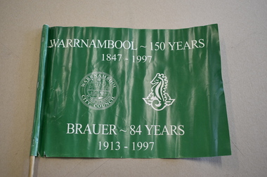
Artefact, Flag, 1997
This small flag has been made by Brauer College in Warrnambool to celebrate the 150th anniversary of the founding of Warrnambool and to mark the 84 years of Brauer College’s existence. Warrnambool was founded in 1847 as a planned town to provide port facilities for the export of produce of the local pastoralists and squatters. Brauer College began as the Warrnambool Technical School in 1913 with John King as the Principal and the original school buildings in Timor Street. In 1958 the school became the Warrnambool Technical College and today this site is occupied by the South West TAFE facility. The secondary school section of Warrnambool Technical College relocated to Caramut Road in Warrnambool and since 1990 has been known as Brauer College. It was named after a local prominent doctor and supporter of State Education – Dr Alfred Brauer. This flag is of some interest as a memento of Warrnambool’s 150th anniversary and of Brauer College’s part in this. This is a rectangular-shaped plastic flag attached with three metal staples to a circular-shaped wooden stick. The flag is green with white printing on both sides and contains the images of the Warrnambool City Council seal and the sea-horse emblem of Brauer College. The flag is partly torn away from the stick at the lower end. ‘Warrnambool -150 years 1847-1997’ ‘Brauer – 84 years 1913-1997’ brauer college, warrnambool, warrnambool’s 150th anniversary -
 Warrnambool and District Historical Society Inc.
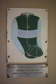
Plaque, Spring Fortune, C 1990
This is one of a series of plaques which commemorated some of the winners of the Grand Annual Steeplechase which is held each year in Warrnambool. It is the longest race at a public course in Australia.The first Grand Annual was held in 1872 as the Warrnambool Handicap Steeplechase. This series of plaques were painted by local artist Leslie Lamey and were originally in the members enclosure at the Warrnambool Racecourse. This plaque notes the win of horse Spring Fortune (NZ) in 1987. These items relate to a significant part of Warrnambool's sporting and social history..1 Painted white rectangular tin plaque with rolled edges with painting of jockey's silks and cap. The colours are green and blue in opposing squares on the front with blue sleeves. The cap is green with white lines. . Six holes are around the edge. .2 Galvanised rectangular metal plate with engraved text. .1 SPRING FORTUNE .2 Messers K.T. MYERS J. McLEOD & T.F. DANAHER SPRING FORTUNE (NZ) WINNER OF THE GRAND ANNUAL STEEPLECHASE 1987 warrnambool grand annual steeplechase, spring fortune -
 Warrnambool and District Historical Society Inc.
Pennant
This pennant was used by one of the school houses at Warrnambool Technical College. Warrnambool Technical School was established in Warrnambool in 1913. The name was changed to Warrnambool Technical College in 1958. In 1974 the junior section of the Technical College was moved to Caramut Road and is now called Brauer College. The senior section became the Institute of Adult Education and moved to Sherwood Park in 1984 , this is now Deakin University. and Timor Street is now Technical and Further Education. The name of the house " Shomberg" comes from the ship that was wrecked near Peterborough, Victoria in 1855.This pennant is retained because of its connection with Warrnambool Technical School, an important educational establishment.A triangular red felt pennant with white felt loops for attaching to a stand. It has white printing and a white image of a sea horse stencilled on.WARRNAMBOOL TECHNICAL COLLEGE " Schomberg" -
 Port of Echuca
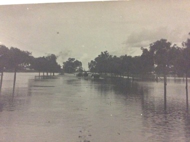
A black and white postcard, 1906. or. 1916
The postcard is significant because it shows the extent of the flood in the early 20th Century. The bridge crosses the Southern Cross channel which had been built as part of the Murray Darling irrigation system. There is a vehicle on the bridge either being towed by bullocks or horses. Floodwaters cover the whole view.The postcard is significant because it shows the extent of the flood in the early 20th Century. The bridge crosses the Southern Cross channel which had been built as part of the Murray Darling irrigation system. It is also near the water filtration plant which filters the town's water supply. There is a vehicle on the bridge either being towed by bullocks or horses. Floodwaters cover the whole view.A black and white postcard showing Goulburn Road, Echuca East, in either the 1906, or 1916 floods.Printed on the back are the words; W. Grimwood Echuca. POST CARD. Correspondence Address Only Kodak Australia. Hand written on the back are the words 1906 or 1916? Southern Cross bridge near filtration plant. Goulburn Road, Echuca East.floods, goulburn road, echuca east, pullicino, j, postcard, southern cross channel, water filtration plant -
 Port of Echuca
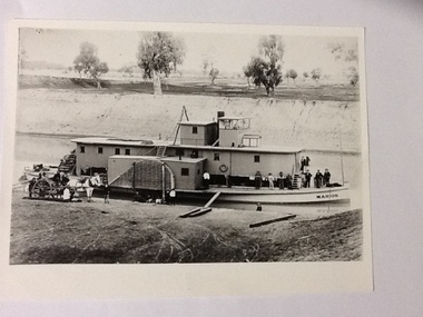
Black and white photograph, Earliest 1897
P. S. Marion Dimensions: 107 ft 11 in X 5 ft 3 in Tonnage: 157 tons Built: 1897, at Milang, S. A. References: Book: "Murray River Paddlesteamers" by D. Wardle. pp.22 Riverboats and Rivermen by W. Drake & M. PagePaddlesteamers were a common form of transport along the Murray river in the early 20th century. This photo shows a number of travellers on the boat, judging by their attire, workmen, cook, men in suits and ties as well as a group of people sitting on the bank, possible a woman and children with dog waiting for the boat to depart. There is also a horse drawn wagon with a number of people on and around it that could be waiting to pick up goods (or have unloaded) from the boat. At the back of the boat stacks of wheat bags (?) are visible.Black and white photograph of P. S. Marion moored by a river bank. There is a group of men standing towards the bow and a horse drawn carriage on the bank near the stern. Copy of an original photograph.On the front: MARION on the bow of the boat and on the wheelhouse. On reverse, in pen: Marion. where? Stamped in black: National Library of Australia.riverboats,, paddle steamers, p. s. marion -
 Warrnambool and District Historical Society Inc.
Badges, Stokes, Warrnambool Racing Club, 1950s
These badges were issued to members of the Warrnambool Racing Club in the 1950s. Horse race meetings have been held in Warrnambool since the early days of European settlement, with the Warrnambool Racing Club formed in 1854. Races have been held on the site of the present day racecourse since the late 1850s. Today the chief event on the Warrnambool racing calendar is the annual three-day May Racing Carnival, featuring the well-known Warrnambool Grand Annual Steeplechase. These badges are retained as examples of the badges of members of the Warrnambool Racing Club in the 1950s. They will be useful for display. .1A metal badge (roughly in the shape of a double triangle) with an image in blue, white, green and gold of a horse and jockey clearing a hurdle. The badge has gold lettering, a metal clip at the back and a metal ring at the top for attachment to a cord. .2 .3. As above except that the colourings of blue, red, green and red are differently placed .4 As above in .1 except that the colourings are black, brown and green .5 A round metal badge with the image as in .1 above, with the colourings being black, white and green. .1 Warrnambool Racing Club Not Transferable Season 1954-55 121 Stokes Melb. .2 Warrnambool Racing Club Not Transferable Season 1955-56 128 Stokes .3 Warrnambool Racing Club Not Transferable Season 1957-58 106 Stokes .4 Warrnambool Racing Club Not Transferable Season 1959-1960 95 Stokes Melb .5 Warrnambool Racing Club Not Transferable Season 1956-1957 123 Stokes warrnambool racing club, history of warrnambool -
 Warrnambool and District Historical Society Inc.
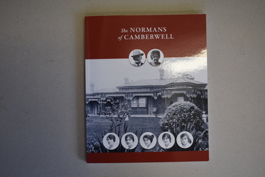
Book, The Normans of Camberwell, 2021
Norman Family HistoryThis is a book of 162 pages. The cover has a brown background with white printing and black and white photographs on the front cover and a colour photograph and printing on the back. The pages contain a Foreword, an Introduction, an Appendix, a Bibliography, printed material and colour and black and white photographs.non-fictionNorman Family Historyhistory of frederick norman and family, william norman -
 Eltham District Historical Society Inc
Photograph, Peter Pidgeon, White Cloud Cottage, 701 Main Road, Eltham, 2 Aug. 2022
Jarrold Cottage built c.1853, also known as 'White Cloud", located at 701 Main Road, Eltham, opposite Dalton Street. The house remains intact and is listed on the Victorian Heritage Database and considered historically significant to the Shire of Nillumbik. The cottage was originally located closer to the Diamond Creek but was subject to flooding. It was dragged by horse to the present site shown, which was chosen for the higher ground that had been created as a result of land fill being deposited here from the quarry further around the bend on Main Road (site of present-day Eltham Primary School carpark) where the stone had been quarried for building the State School in Dalton Street. It had previously been rented for use as a Police Station / residence prior to the building of the permanent police house and station at the corner of Maria and Brougham streets in 1859. The cottage was purchased by Lena Skipper after the death of Thekla Jarrold in 1943 and remains in the family to present day (2022). Comparison photo: SEPP_0749 Part of a presentation by Peter Pidgeon to the Society, 13 August 2022 showcasing a series of photographs taken by John Henry Clark over the period 1895 to 1930. John Henry Clark was the youngest of three boys born to William Henry Clark (1823-1877) and Maria White (1843-1914). He and his brothers, William Charles Clark (1872-1945), Clement Kent Clark (1874-1912) operated a photography business (Clark Bros.) from 25 Thomas Street, Windsor near Prahran during the period c.1894 to 1914. Following death of Clement in September 1912 and their mother in 1914, the Clark Bros business appears to have dissolved, the premises demolished, and a new house was under construction in 1915. John set up business independently in 1914 operating out of 29 Moor Street, Fitzroy where he is registered in the 1914 and 1915 Electoral Rolls. By 1916 John had relocated to Eltham where he continued his practice as a photographer and took many of the early images around the district of Little Eltham. Around 1930 John changed professions and opened a small cobbler's shop in 1931 near the pond opposite Dalton Street adjacent to the Jarrold family cottage. He never married and continued his profession as a bootmaker from this little shop, maintaining a close relationship with Mrs Jarrold for the rest of their lives. His bootmaker shop remains today beside the Whitecloud cottage and is one of only three remaining shops in the area from the early 20th century.Comparative photo taken 2022 with one taken from same location over 100 years earlier by noted local photographer J.H. ClarkBorn Digitaleltham, j.h. clark photo (2022), dalton street, main road, bootmaker's shop, jarrold cottage, white cloud cottage, avenue of honour -
 Eltham District Historical Society Inc
Photograph, Peter Pidgeon, White Cloud Cottage, 701 Main Road, Eltham, 2 Aug. 2022
Jarrold Cottage built c.1853, also known as 'White Cloud", located at 701 Main Road, Eltham, opposite Dalton Street. The house remains intact and is listed on the Victorian Heritage Database and considered historically significant to the Shire of Nillumbik. The cottage was originally located closer to the Diamond Creek but was subject to flooding. It was dragged by horse to the present site shown, which was chosen for the higher ground that had been created as a result of land fill being deposited here from the quarry further around the bend on Main Road (site of present-day Eltham Primary School carpark) where the stone had been quarried for building the State School in Dalton Street. It had previously been rented for use as a Police Station / residence prior to the building of the permanent police house and station at the corner of Maria and Brougham streets in 1859. The cottage was purchased by Lena Skipper after the death of Thekla Jarrold in 1943 and remains in the family to present day (2022). Part of a presentation by Peter Pidgeon to the Society, 13 August 2022 showcasing a series of photographs taken by John Henry Clark over the period 1895 to 1930.Born Digitaleltham, dalton street, main road, bootmaker's shop, jarrold cottage, white cloud cottage -
 Glen Eira Historical Society
Document - Linlithgow Ave, 4 Caulfield North
A heritage study from the City of Glen Eira Heritage Management Plan by Andrew Ward, 1996 on Linlithgow, 4 Linlithgow Avenue, Caulfield North. Report details the building’s significance, history and exterior and interior features. Includes references and a photocopied black and white photograph of the exterior.linlithgow, linlithgow avenue, linlithgow co-ed college, caulfield north, ward andrew, streamline moderne, art deco, duncan william, melbourne jockeys premiership, melbourne cup, slaney h, glen eira road, wood samuel, wood muriel, bambra road, jackson archibald, golding elizabeth, inkerman hotel, stables, horse racing, horse training, city of glen eira heritage management plan, haase eva nm, favelle bessie bain, favelle jack joseph, architectural styles, architectural features -
 Glen Eira Historical Society
Document - London Tavern
This file contains eight items: 1/A one page typed summary of the history of the London Tavern by (noted in pencil) author J O'Donnell. Includes information on the licensees of the hotel from 1873-1927 (in duplicate) 2/Photocopy of black and white photo of London Tavern c. 1878. Shows sign 'J. Riordan, London Tavern and Store'. Shows Boot and Shoe Repair shop at end and two women outside and horse and buggy on road. 3/Photocopy of black and white photograph entitled 'London Tavern 1935' with handwritten note on reverse by unknown author identifying Mrs. A.C. Scott as Nominee 1929-1969 and identifying a man in the photograph as John Chas (Jack) Scott on left. Car parked at curb. Original print held in album 'Historical Caulfield to 1972'. 4/Half page written note listing the names of Nominees of the London Tavern from 1873-1895. Author unknown; undated. 5/'now&then' article on London Tavern showing three photos (from our files) and brief history. Melbourne Weekly Bayside 22/02/2012. 6/Black and white photograph of London Tavern, established 1886, currently 414 Hawthorn Road. Foreground includes a large crowd with bicycles noted by an unattributed source to be members of Camden Town Sports Club after a bicycle race c.1888. 7/Handwritten note showing John Guess as the proprietor of the London Tavern in 1867 and 1874. Noet is undated and author unknown. 8/Black and white photograph of the London Tavern with a 1970s style car parked in Sycamore Street. Date and photographer unknownhawthorn road, caulfield, london tavern, woods a.j., camden town sports club, gribble c., hotels, sporting clubs, scott a.c., guess john, guess louisa, evans rowland, riordan john, scott mrs., boot and shoe repair shop, vine beer house, balaclava road, hawthorn road, sycamore street, caulfield south, elsternwick, harley susan, mott h, nichols william h, o'donnell j, rosstown hotel, caulfield club hotel, grocer -
Glen Eira Historical Society
Photograph - Elsternwick Fire Station, Selwyn Street
A photocopied black and white photograph (96mm x 127mm) of the 1891 Elsternwick Fire Brigade on their way to a fire with a crew of three fire fighters in a one-horse cart racing up a track.elsternwick, fire brigades, fire fighters, elsternwick fire brigade, horse drawn vehicles, carts and wagons -
 Glen Eira Historical Society
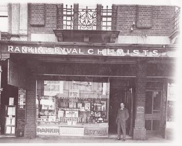
Photograph - Glenhuntly Road, Elsternwick
11 photographs of Glen Huntly Road, Elsternwick, from horsedrawn carriage days to the 1980s: A black and white photograph (200mm x 253mm) of Hulbert Gorrie standing outside the shop front of Rankin and Eyval Chemists at 35 Glen Huntly Road Elsternwick. Date and photographer unknown. Three black and white photographs (107mm x 130mm; 88mm x 140mm; 88mm x 88mm) of shop fronts on Glen Huntly Road taken in different eras. A horse drawn vehicle and women in long dresses are shown in one of the photographs. The other two most likely date to the 1960s. Exact dates and photographers unknown. Seven colour photographs of advertising signs revealed when a building on Glen Huntly Road was demolished in the 1980s to build the Bank of New South Wales.gorrie hulbert, rankin and eyval chemists, cast iron work, pharmacies, balconies, chemists, architectural features, advertising signs, selwyn street, p calandro and co, estate agents, elsternwick, chinese café, j higgins, glen huntly road -
 Eltham District Historical Society Inc
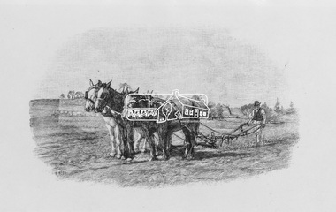
Photograph, Sketch by Walter Withers, 1971
Reproduced Page 13 of Pioneers & Painters, edited by Alan Marshall (1971) Source: National Gallery of Victoria (1 Black and White print, no neg.) This photo forms part of a collection of photographs gathered by the Shire of Eltham for their centenary project book,"Pioneers and Painters: 100 years of the Shire of Eltham" by Alan Marshall (1971). The collection of over 500 images is held in partnership between Eltham District Historical Society and Yarra Plenty Regional Library (Eltham Library) and is now formally known as the 'The Shire of Eltham Pioneers Photograph Collection.' It is significant in being the first community sourced collection representing the places and people of the Shire's first one hundred years.Digital imagehorse, pioneers and painters, plough, shire of eltham pioneers photograph collection, walter withers, sepp