Showing 1416 items matching "bushfires"
-
 Marysville & District Historical Society
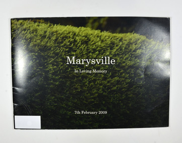
Book, Julia Peddie, Marysville-In Loving Memory, 2009
A book of photographs taken in and around Marysville before the 2009 Black Saturday bush fire.Front cover has a photograph of what appears to be a hedge. Back cover has a photograph of Steavensons Falls.non-fictionA book of photographs taken in and around Marysville before the 2009 Black Saturday bush fire.marysville, victoria, history -
 Marysville & District Historical Society
Book, Julia Peddie, Marysville-In Loving Memory, 2009
A book of photographs taken in and around Marysville before the 2009 Black Saturday bush fire.Front cover has a photograph of what appears to be a hedge. Back cover has a photograph of Steavensons Falls.non-fictionA book of photographs taken in and around Marysville before the 2009 Black Saturday bush fire.marysville, victoria, history -
 Ringwood and District Historical Society
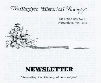
Photograph, Warrandyte Historical Society Newsletters nos. 76-84
Digitised WHS newsletters from December 1990 (no. 76) to October 1990 (no. 84). Sent to Secretary of the Ringwood Historical Research Group, Jack Lindsay.Noteable articles:- Earl Stewart bus service Brackenbury Street Yarra Yarra Mining Company Dr Owen's Puddling Machine 1927 bushfires Schult Steven Houghton Taffy Jones Great Southern Hill Caledonia Gold Mine Mary Hill - South Warrandyte Post Office Artists - Nutter Buzacott, Frank Crozier, Penleigh Boyd, William Frater, Christine Gray-Aldor Warrandyte Primary School Potter's Cottage -
 Otway Districts Historical Society
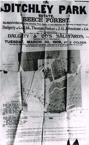
Photograph, Knox Collection, Sale of the Ditchley Park Estate, Beech Forest, 1908
Commercial realities and bushfires caused the Beech Forest community to re-establish itself around the railway station, away from Gardner Hill. This caused John W. Gardner to subdivide his land on the north side of the railway station. One subdivision was created near the Ditchley railway station on the old racecourse site, and another of 25 allotments forming what became Southorn Street. There were very few takers for these lots nor any buyers for the Ditchley subdivision.Photocopy. 260mm x 159mm. An advertisement for the sale of the Ditchley Park Estate, Beech Forest. Under instructions from Mr. J.W. Gardner Dalgety & Co. Ltd. will sell the subdivision of the Ditchley Park Estate on Tuesday, March 30, 1909, at 2 o'clock. A map of Beech Forest township and the Ditchley Park Estate is attached, as are the terms of sale and a description of the area.. beech forest; ditchley park; land sale; advertisment; -
 Nillumbik Shire Council
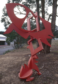
Public Art: Edward GINGER (b.1951 Kegalle, Sri Lanka - arrived 1975 Aus), Edward Ginger, The Breeze, Location: Main Road, Research - opposite Eltham Little Theatre, 1990
The first sculpture awarded the Shire of Eltham 'Art in Public Places' Award/Commission. The Judges were Inge King, Jenny Zimmer and Daryl Jackson. The work deals with the juxtaposition of suburban and rural surroundings. This scupture is a typical example of the artist's oevre of the period. This sculptre is site specific and refers to the nature of the environment. The colour - bushfire red / sienna - alludes to the history of fire in the urban/rural fringe and the title, as well as the sculpture's shapes, forms and material refer to the natural and local elements. Judges report noted: "The most vital and expressive work for the site...with a great sense of dynamic movement and vibrant colour. Its' abstract forms will enliven the surroundings and the urban and natural environment. This work is the most appropriate for the site and expressive of the dynamics of an evolving community in which artistic discourse and debate has always thrived." The work has acquired the status of a major landmark from the National Trust. The Breeze is an abstract work made out of welded steel and painted in enamel in bush fire red / sienna. It comprises a series of flat, cut-out shapes, interlocking at different angles, giving the impression of being hinged together rather than fixed. The work references nature and the built environment. Its geometric shapes suggest man-made structures within industry and suburban life, while rural areas can be identified by the organic flame-like shapes fanned by the wind. The circular cut-out in the eye mimics the sun, symbolising the intense heat of the Australian climate, while the colour red alludes to the history of bushfire within the urban and rural fringe. N/Apublic art, ginger, red, sienna, elements, steel, abstract, breeze, fire, sculpture -
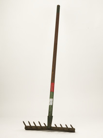 Forests Commission Retired Personnel Association (FCRPA)
Rakut - Fire rake, Unknown FCV District, c 1952
Bushfire perimeter rather than bushfire area is the main control problem for firefighters on the ground. A conundrum rapidly compounded by spot fires. A small 5 ha fire can be nearly 1 km around the perimeter. That's a long way to build a control line by hand in rough bush. Dry firefighting techniques by hand were mostly confined to “knocking down” or “beating out” the flames, as well as "digging out". Digging or raking a “mineral earth” trail down to bare dirt proved most effective in forest fuels which, unlike grass, tend to retain heat and smoulder. Early tools were whatever happened to be close at hand. They were simple and primitive and included shovels, slashers, axes, hoes, beaters and rakes. A cut branch to beat the flames was often the only thing available. Farming and logging tools, developed over centuries of manual labour, and readily available at local hardware stores came into use, but little thought was given to size, weight, and balance. For years foresters experimented with combination tools. In about 1952 fire beaters and other implements were being replaced with Rakuts.Fire tool used before the introduction of RakehoesRakut - Fire Rake and cutting toolGreen and red coloured handle and 020 marking indicated which FCV District the tool belonged tobushfire -
 Eltham District Historical Society Inc
Photograph, Barry Philp, Second Hand store at the southeast corner of Reynolds Road and Main Road, Eltham, c.1969
... bushfires ...Corner of Reynolds Road. The store is on the left, the house on the right was the home of the Dodkins family (Phographer Barry Philp's uncle and aunty). The house on the hill was Philbrick's home which burnt out in the bush fires.bushfires, dodkins family home, fire damage - buildings, main road, philbrick family home, research (vic.), reynolds road, second hand dealer, victorian bushfires - 1969, eltham, eltham-yarra glen road -
 Kiewa Valley Historical Society
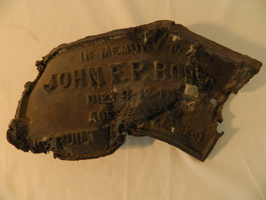
Roper's Hut Memorabilia
Roper's Hut was built in 1939 and was burnt down in 2003. It was rebuilt in 2008 and is situated on the Bogong High Plains on Duane Spur (where Duane's hut had been before it too was destroyed by (1939) bushfires, between Mt Nelse and Big River. The original hut was used as a shelter for cattlemen who grazed their cattle on the High Plains during summer. The Victorian High Country Huts Association Inc. members and friends helped rebuild the hut which is now used as an emergency shelter for visitors to the High Plains.The memorabilia is significant as the items belonged to the Roper family who were one of the original settlers of the Kiewa Valley and one of the original families who drove their cattle up to the Bogong High Plains. The burnt plaque and forks and the rebuilding of the huts (Duane's & Roper's) are significant as bush fires are a constant threat to the Bogong High Plains destroying large areas at a time.1. Bronze Plaque and 2 damaged forks from Roper's Hut which was destroyed by bush fires in 2003. 2. DVD & USB and hard copy photos of the rebuild of Roper's Hut in January 2008.The plaque had 'In Memory of / John F. P. Roper/ died 3-12-1977 / Aged 78 years / He built the original hut Feb. 1939'roper's hut, cattlemen, bogong high plains, bronze plaque, roper family, bush fires -
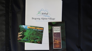 Kiewa Valley Historical Society
Papers - Bogong Village & the 'Commissioner's' Lodge & Progress Association Members, c 1997/1998
Bogong Village was built by the SECV in 1940 for the workers of the Kiewa Hydro Electric Scheme. In 1971, 30 houses were furnished for use as holiday homes for SEC personnel throughout the State. From 1989 to 1993 the houses were restored & renovated.During the 1990s the buildings in the village had been leased to private owners. Many of them rented their houses for tourists. The Commissioner's lodge was on the other side of the Mt Beauty - Falls Creek road, above Bogong Village. Wally Baldwin ran it in the 1960's.It was destroyed by the 2003 bushfires.These papers present a history of 'the Commissioner's lodge' and Bogong Village in the 1990's. The Progress Association was an active community group in 1963/64.Papers advertising Bogong Village & the Lodge for accommodation with rates 1997/1998. Describes the alternatives, maps and cafe hours, Also, 'Jan's Recollections' and on the back of these pages a hand written list of members of the the Progress Association 1963-64 as 'per Mr A. McCullough's spiel'. In original folder and includes a pamphlet & postcard.bogong village, secv lodge, lake guy, state electricity commission of victoria., kiewa hydro electric scheme, tourism, accommodation -
 Marysville & District Historical Society
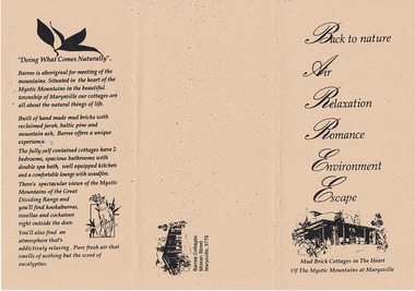
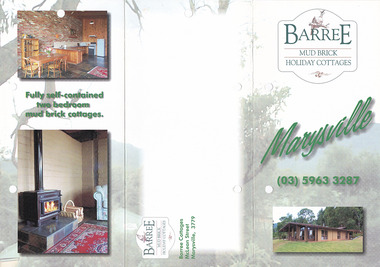
Ephemera (Item) - Information brochure, BARREE, Unknown
An information brochure regarding Barree Cottages in Marysville. The cottages were built of 110 year old recycled Jarrah from the Fremantle Wool Stores. They had 90 year old Mountain Ash (native to the area) posts and beams from the South Melbourne Wool Stores. Old red bricks were used to create feature walls within the cottages which were two bedroom and fully self contained. These cottages, along with the majority of the buildings in Marysville, were destroyed in the 2009 Black Saturday bushfires.An information brochure regarding Barree Cottages in Marysville.marysville, victoria, australia, information brochure, barree mud brick holiday cottages, accommodation, 2009 black saturday bushfires -
 Ringwood and District Historical Society
Document - Department of Lands and Survey, Wire Netting Branch, Melbourne, Victoria, Application for Vermin-Proof Fence Certificate - L.J. Mills vs John Collins, Grandview Grove, Ringwood, Victoria - 1939
Photocopied file of corresponence and documentation relating to a claim by L.J. Mills, Nurseryman, that adjoining property owner, J. Collins, Farmer, assists with replacement of a vermin proof wire netting dividing fence destroyed by 1939 bushfire. File includes 1939 and 1940 detailed property inspection reports by Vermin and Noxious Weeds Branch, Lands Department, Lilydale, describing land use in the area and signs of vermin activity. Application approved 18th April, 1940. Appeal lodged by Mr Collins disallowed in May, 1940. File closed June, 1940 with Departmental suggesion that Mr Mills consider further legal action through a Solicitor as fence had still not been wire-netted. TRANSCRIPTS: Vermin & Noxious Weeds Inspection Reports "19/9/1939 (To) Superintendent (Department of Lands and Survey, Melbourne) Re L.J. Mills application for Vermin Proof Fence. I called on Mr Mills yesterday 18th instant in connection with this matter. Mr Mills has a flower farm and claims that rabbits and hares are damaging his flowers. He showed me a bed of carnations which he stated were being damaged by rabbits. There was evidence of some leaves being nipped off, but I am unable to say whether this is due to rabbits or grubs. Very little if any real damage is being done. The property is netted on the east and south boundary and on half the north and west boundary. The surrounding country is undlating and fairly steep in places. The land to the east across Grandview Avenue (sic) is all planted out in old established orchards and well cultivated. Cleared grass land adjoins the south boundary and bush land adjoins the north and west boundaries. I walked over a large area surrounding Mr Mills land and never saw any rabbits or hares or any indications of rabbits. This locality is not rabbit infested and very little wire netting is being used. I do not consider that a vermin proof fence is necessary between these allotments. - Jas H Allison (Inspector, Vermin and Noxious Weeds Branch, Lands Department, Lilydale)." Follow up report following renewal of application for Certificate by Mr Mills, citing rabbits causing considerable damage to his flowers. He laid poison and obtained 9 carcases and stated that there is evidence of rabbit infestation from the adjoing land. "19/3/1940 (To) Mr Hannah (Superintendant, Department of Lands and Survey, Melbourne) Re L.J. Mills, Grandview Grove Ringwood, Lot 4 Grandview Estate Pt CG20 Ph of Warrandyte. I interviewed Mr Mills at his home on 15th inst. He showed me carcases of rabbits which he stated had been poisoned on his land. In places young plants had been nipped off apparently by rabbits. I made an inspection of adjoining properties and found one live burrow close to Mr Mills northern boundary. There were scratches and other evidence of rabbits on land north and west of Mr Mills property. In view of the present evidence of rabbits I consider that a vermin proof fence is now necessary to protect the flowers grown by Mr Mills. His land is netted on whole of east and south boundary and half way on west and north boundary. The adjoining land on west and north boundaries is owned by Mrs Linda Collins and John Collins resp of Brysons Road East Ringwood. - Jas H Allison (Inspector, Vermin and Noxious Weeds Branch, Lands Department, Lilydale)." -
 Eltham District Historical Society Inc
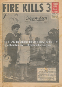
Newspaper - Newspaper articles, Sun News-Pictorial, Fire Kills 3, The Sun News-Pictorial, Thursday, March 4, p1, 1965
Various news articles pertaining to the January 1965 Victorian bushfires specifically with a focus on fires at Eltham North. Specific Eltham Shire districts mentioned include Eltham North on page 1, 2, 3, 28-29 • Fire Kills 3, p1 (Illust.) • Fire on their heel, p2 (Illust.) • Flames catch, kill 3 as they run: 12 house go, p3 (Illust.) • It doubled back, p3 • Helpers highly praised, p3 • Blaze kills 100 puppies, p3 (Illust.) • Scenes from Eltham’s Black Wednesday, pp28-29 (Illust.) tom fielding collection, victorian bushfires - 1965, victorian bushfires – 1965, glen park road, eltham north, sunny pine, bushfire damage – buildings, back gully, gippsland, glenmaggie, briagolong, george john crowe, john lawrence coleman, william john elwers, creek road, wattle glen, bill guy -
 Marysville & District Historical Society
Photograph (Item) - Colour photograph
A colour photograph of one of the Barree Mud Brick Holiday Cottages in Marysville. The cottages were built of 110 year old recycled Jarrah from the Fremantle Wool Stores. They had 90 year old Mountain Ash (native to the area) posts and beams from the South Melbourne Wool Stores. Old red bricks were used to create feature walls within the cottages which were two bedroom and fully self contained. These cottages, along with the majority of the buildings in Marysville, were destroyed in the 2009 Black Saturday bushfires.A colour photograph of one of the Barree Mud Brick Holiday Cottages in Marysville.marysville, victoria, australia, barree mud brick holiday cottages, accommodation, 2009 black saturday bushfires, photograph -
 Eltham District Historical Society Inc
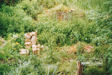
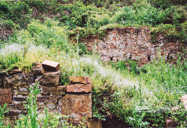
Photograph, Ruins of Coulstocks Mill, Janefield, South Morang
Mill Park Farm at Janefield on the Plenty River was established around 1840 by George Coulstock where he grew wheat. His flour mill was one of the first in Victoria, under construction as early as 1841. After bushfires and Coulstock's early death in 1842, the farm and its mill were taken over by local landowners Henry Miller and John Brock. Peter Hurlestone took charge of the mill. With water diverted from the Plenty River to fill the newly built Yan Yean Reservoir which opened in 1857, the Hurlestone family quit and that was the demise of the mill.Four colour photographs showing the ruins of Coulstocks Flour Mill (Janefield Mill), Janefield. 1. Stone wall 2. Old mill 3. Stone remains of old mill 4. Tree near old mill sitemills, flour mills, coulstock, janefield, plenty river, ruins, stone walls, plenty gorge, bundoora -
 Eltham District Historical Society Inc
Photograph, Ruins of Coulstocks Mill, Janefield, South Morang
Mill Park Farm at Janefield on the Plenty River was established around 1840 by George Coulstock where he grew wheat. His flour mill was one of the first in Victoria, under construction as early as 1841. After bushfires and Coulstock's early death in 1842, the farm and its mill were taken over by local landowners Henry Miller and John Brock. Peter Hurlestone took charge of the mill. With water diverted from the Plenty River to fill the newly built Yan Yean Reservoir which opened in 1857, the Hurlestone family quit and that was the demise of the mill.Five colour photographs of ruins of Coulstocks Mill, Janefield (Mill Park - Bundoora)mills, flour mills, coulstock, janefield, plenty river, ruins, stone walls, bundoora, plenty gorge -
 Marysville & District Historical Society
Ephemera (Item) - Information brochure, BARREE MUD BRICK HOLIDAY COTTAGES, 02-2001
An information brochure regarding Barree Mud Brick Holiday Cottages in Marysville. The cottages were built of 110 year old recycled Jarrah from the Fremantle Wool Stores. They had 90 year old Mountain Ash (native to the area) posts and beams from the South Melbourne Wool Stores. Old red bricks were used to create feature walls within the cottages which were two bedroom and fully self contained. These cottages, along with the majority of the buildings in Marysville, were destroyed in the 2009 Black Saturday bushfires.An information brochure regarding Barree Mud Brick Holiday Cottages in Marysville.marysville, victoria, australia, information brochure, barree mud brick holiday cottages, accommodation, 2009 black saturday bushfires -
 Melton City Libraries
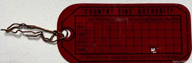
Equipment, Country Fire Authority Tag, Unknown
"From the earliest days of settlement in the shire, residents demonstrated their willingness to band together in times of crisis and need. Bushfires were always a terrifying prospect and since its establishment in 1935, the local fire brigade (later the Country Fire Authority) fought hard to protect the people, homes and animals of the shire. In 1966, the Mount Cottrell Fire BrigadesGroup was formed as a way of consolidating the smaller groups around Melton, Rockbank, ToolernVale, Sydenham, Truganina and Werribee. Its headquarters were established at the home of Ernest ‘Bon’ and Edna Barrie in Ferris Road, Melton".Tag from an fire extinguisher emergency services -
 Linton and District Historical Society Inc
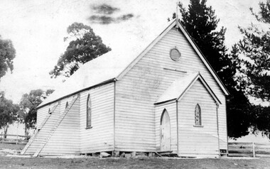
Photograph, Church Building : two possible identifications : Catholic Church at Berringa or St Mark's Church of England, Happy Valley
Two identifications of this building have been made: 1. The copy of the photograph in the LDHS collection was donated from the estate of Mag Gorman, and was identified as the Catholic Church at Berringa, which was moved after the gold mining days to Willowvale, where it burnt down in the bushfires of 1944. 2. The same photograph is on p. 249 of Joan Hunt's book "Springdallah", where it is identified as St Mark's Church of England, Happy Valley. This building was later moved to Skipton (1913) and then again to Carranballac (1924) (see "Centenary History of St Paul's - Linton, p. 25.)Black and white post card photograph of a wooden church, with trees and a post and rail fence around it. Two possible identifications: Catholic Church at Berringa or St Mark's Church of England, Happy ValleyStamped on reverse: "T.W.Nelson, Linton".catholic church berringa, catholic church willowvale, st mark's church of england happy valley -
 Eltham District Historical Society Inc
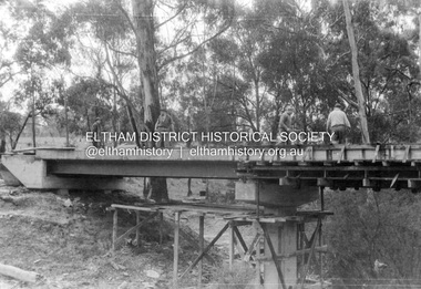
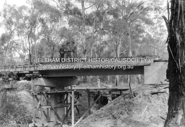
Album - Photograph, J.A. McDonald, Henley Road Bridge over Watsons Creek, Aug. 1962
... bushfires ...Henley Road Bridge over Watsons Creek Eltham Abutment August 1962Record of various Shire of Eltham infrastructure works undertaken during the period of 1952-1962 involving bridge and road reconstruction projects, sometimes with Eltham Shire Council Project Reference numbers quoted. It was during this period that a number of significant improvements were made to roads and new bridges constructed within the shire that remain in place as of present day (2022). In many situations, the photos provide a tangible visible record of infrastructure that existed throughout the early days of the Shire. The album was put together by or under the direction of the Shire Engineer, J.A. McDonald.H941 stamped on reverse (film processing #)infrastructure, shire of eltham, bridge construction, road construction, bushfires, 1962-08, bend of islands, henley road, henley road bridge, kangaroo ground, oxley bridge, watsons creek -
 Eltham District Historical Society Inc
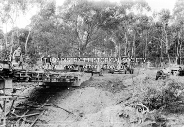
Album - Photograph, J.A. McDonald, Henley Road Bridge over Watsons Creek, Aug. 1962
... bushfires ...Henley Road Bridge over Watsons Creek Yarra Glen Abutment August 1962Record of various Shire of Eltham infrastructure works undertaken during the period of 1952-1962 involving bridge and road reconstruction projects, sometimes with Eltham Shire Council Project Reference numbers quoted. It was during this period that a number of significant improvements were made to roads and new bridges constructed within the shire that remain in place as of present day (2022). In many situations, the photos provide a tangible visible record of infrastructure that existed throughout the early days of the Shire. The album was put together by or under the direction of the Shire Engineer, J.A. McDonald.H941 stamped on reverse (film processing #)infrastructure, shire of eltham, bridge construction, road construction, bushfires, 1962-08, bend of islands, henley road, henley road bridge, kangaroo ground, oxley bridge, watsons creek -
 Eltham District Historical Society Inc
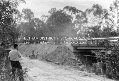
Album - Photograph, J.A. McDonald, Henley Road Bridge over Watsons Creek, Sep. 1962
... bushfires ...Henley Road Bridge over Watsons Creek Eltham Abutment September 1962Record of various Shire of Eltham infrastructure works undertaken during the period of 1952-1962 involving bridge and road reconstruction projects, sometimes with Eltham Shire Council Project Reference numbers quoted. It was during this period that a number of significant improvements were made to roads and new bridges constructed within the shire that remain in place as of present day (2022). In many situations, the photos provide a tangible visible record of infrastructure that existed throughout the early days of the Shire. The album was put together by or under the direction of the Shire Engineer, J.A. McDonald.H941 stamped on reverse (film processing #)infrastructure, shire of eltham, bridge construction, road construction, bushfires, bend of islands, henley road, henley road bridge, kangaroo ground, oxley bridge, watsons creek, 1962-09 -
 Eltham District Historical Society Inc
Album - Photograph, J.A. McDonald, Henley Road Bridge over Watsons Creek, Sep. 1962
... bushfires ...Henley Road Bridge over Watsons Creek Yarra Glen Abutment September 1962Record of various Shire of Eltham infrastructure works undertaken during the period of 1952-1962 involving bridge and road reconstruction projects, sometimes with Eltham Shire Council Project Reference numbers quoted. It was during this period that a number of significant improvements were made to roads and new bridges constructed within the shire that remain in place as of present day (2022). In many situations, the photos provide a tangible visible record of infrastructure that existed throughout the early days of the Shire. The album was put together by or under the direction of the Shire Engineer, J.A. McDonald.H941 stamped on reverse (film processing #)infrastructure, shire of eltham, bridge construction, road construction, bushfires, bend of islands, henley road, henley road bridge, kangaroo ground, oxley bridge, watsons creek, 1962-09 -
 Eltham District Historical Society Inc
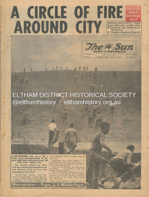
Newspaper - Newspaper articles, Sun News-Pictorial, A Circle of Fire Around City, The Sun News-Pictorial, Friday, March 12, p1, 1965
Various news articles pertaining to the January 1965 Victorian bushfires specifically with a focus on fires at Eltham North. Specific Eltham Shire districts mentioned include Eltham, Diamond Creek, Warrandyte on page 1 and page 3, Warrandyte on page 4 • A Circle of Fire Around City, p1 (Illust.) • A home is saved, p2 (Illust.) • 18 houses, hall and store lost, p2 • Battle for the trees, p3 (Illust.) • Six houses go in two suburbs, p3 (Illust.) • A sleepless town waited, p4 (Illust.) • Fire in the near hills, pp28-29 (Illust.) tom fielding collection, victorian bushfires - 1965, victorian bushfires – 1965, greensborough, diamond creek, warrandyte, eltham, gippsland, romsey, toolern vale, melton, rockbank, laughing waters, ken guest, eltham state school no. 209, a. smith, ray freeman, sassafras, diamond creek-greensborough road, warrandyte hall, bushfire damage – buildings -
 Orbost & District Historical Society
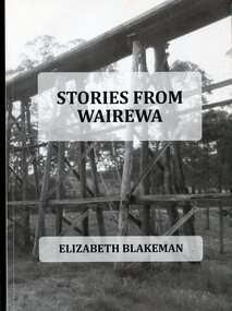
Book, Stories From Wairewa, 2017
This book is a social history collected orally and from the private records of residents of the Wairewa Valley, Victoria, Australia. It includes a brief history of the old primary school. Appended is a performance piece 'Waltz for Wairewa", a dialogue with poems and songs. It was sponsored by the Hospital Creek Bush Band and Dance Group. The book was partly the result of two song writing courses, one run on-line for six weeksby Sheffield University, U.K., and another year-long course at U3A in Lakes Entrance, East Gippsland. The bridge pictured on the front cover is O'Grady's railway bridge which was severely damaged in the bushfires of January 2020.This item is a useful reference on the history of the Wairewa Valley, East Gippsland.A soft covered book, titled "Stories From Wairewa". On the front cover is a tall wooden rail bridge. the book contains stories, photographs, scanned documents, shet music, drawings and poetry. book-wairewa blakeman-elizabeth school-wairewa -
 Clunes Museum
Weapon - NAVAL CANNON, 1847
IT IS ON PERMAMENT LOAN FROM HEPBURN SHIRE THE CANNON WAS ORIGINALLY ON THE BRITISH NAVAL SHIP "NELSON" IN FEBRUARY 1867. "NELSON" WAS HANDED OVER TO THE VICTORIAN NAVAL FORCES, ON LOAN FROM THE ROYAL NAVY. "NELSON" WAS SOLD 1898, IT IS BELIEVED THAT THE GUNS WERE THEN OFFERED FOR SALE TO COUNCILS. IT WAS DISPLAYED ON A SITE NEAR THE SCENIC ROAD, CLUNES, UNTIL THE WOODEN UNDERCARRIAGE WAS DESTROYED BY THE BUSHFIRES IN 1944. IT WAS LATER RETRIEVED AND KEPT IN THE CLUNES BOROUGH COUNCIL YARD UNTIL IT WAS RESTORED BY THE APPRENTICES AT THE BENDIGO ORDNANCE WORKSHOPS IN 1895. THE TIMBER USED FOR THE RESTORATION WAS TAKEN FROM AN ELM TREE NEAR THE CREEK IN CLUNES..1 NAVAL CANNON MOUNTED ON A WOODEN UNDERCARRIAGE. .2 CANNON BALLlocal history, military history, navy, military -
 Warrnambool and District Historical Society Inc.
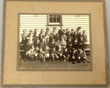
Photograph, Naringal School 1932, C 1932
The Naringal school was originally known as Tallangatta S S when it was opened in 1877. The era of this photograph saw enrolments increase from around 39 to 59. Headteacher at the time and in this photograph is Mr Wellman. One of its most eminent past pupils was Sister Mona Wilson who was also sewing mistress for a short time before commencing nursing training. She sailed with the 8th division in 1941. and was lost at sea when the ship "Viner Brook " was sunk after being bombed by the Japanese. The Naringal Primary School was burnt to the ground in the Ash Wednesday Bushfires 1983. An interesting depiction of a country school's enrolment in the 1930's. Having been taken in the time of the Great Depression. As the school was destroyed in the Ash Wednesday Bushfires, in 1983 so surviving items relating to the school are limited. Small black and white photograph mounted on fawn card with darker border on the edge and also around the photograph. It depicts 38 children with teacher in back row. Naringal School No 1839, 1932 on board.naringal, tallangatta victoria, mr wellman naringal, naringal primary school 1932 -
 Melton City Libraries
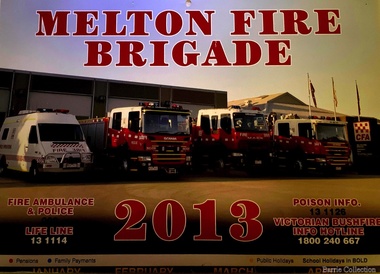
Document, Melton Fire Brigade 2013 Calendar, 2013
"From the beginnings of European settlement on the dry plains of Melton, the community became all too familiar with the destructive power of bushfires. Fires spread rapidly through the parched landscape and were difficult to stop. Small villages in the district were practically wiped out by different fires at various times, important buildings and valuable haystacks were lost, and most chaff mills were burned down more than once.110 A local bushfire brigade was established in 1935, with Constable Roy Corbett elected Captain. This formed the basis of what would later become the Melton Country Fire Authority (CFA) branch". During 1935 a Fire Brigade was organised by 1942 it had been registered with the BUSH FIRE BRIGADE COMMITTEE and a Certificate of Registration No 425 was issued. The Officers were as follows:- 1st Lieutenant E.W. Barrie 2nd Lieutenant T.L. Barrie 3rd Lieutenant Tom Knox Captains who followed Roy Corbett List of known Captains 1935 – 1975 Jack Wallace Roy Corbett Bon Barrie Edgar Barrie Steve Hirt In 1945 the C.F.A. became the controlling authority. Prior to this date D24 was the Nerve Centre of the Fire Fighting System with representatives of Country Fire Brigades, Forests Commission and D24. This information was in a typed document prepared by Edna Barrie 1975 Melton Fire Brigade yearly calendar emergency services -
 Orbost & District Historical Society
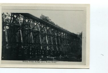
black and white photograph, first half 20th century
The Stony Creek Trestle Bridge was built in 1916 when the existing rail line from Melbourne to Bairnsdale was extended to Orbost. This 97km Bairnsdale to Orbost extension through rugged terrain was reputed to have been the most difficult rail project undertaken in Victoria. In service for over 60 years the bridge was damaged by bushfire in 1980, with the last train crossing in 1987. At 247m long and 20m high, it is the largest standing bridge of its kind in the State, and is listed on the Register of Historic Sites. Built of red ironbark and grey box timber, it is a fine example of the early engineering skills that utilised the resources and materials found on site.The Bairnsdale to Orbost rail line contains the most varied range of timber & timber composite bridges on any Victorian line. The Stoney Creek bridge is listed on the Victorian Heritage Register for its architectural and historical significance. A black / white photograph of a very tall wooden railway bridge with a train along the top.railway-bridge stoney-creek-bridge east-gippsland-railway -
 Eltham District Historical Society Inc
Photograph - Digital Photograph, Marguerite Marshall, Strathewen Primary School, 20 August 2008
The school building originally owned by locals was lost in the Black Saturday 2009 bushfires. Land was purchased in 1914 to build he Strathewen State School on School Ridge Road, Strathewen. Residents and the Education Department contributed funds for the building which the Education Department then leased for a small annual fee. The school opened with one teacher in 1917 with no equipment. In 1921 the Education Department provided desks and a hexagonal shelter shed and took control in 1925. After this photo was taken, the school was destroyed in Black Saturday on 9 February 2009. Published: Nillumbik Now and Then / Marguerite Marshall 2008; photographs Alan King with Marguerite Marshall.; p89This collection of almost 130 photos about places and people within the Shire of Nillumbik, an urban and rural municipality in Melbourne's north, contributes to an understanding of the history of the Shire. Published in 2008 immediately prior to the Black Saturday bushfires of February 7, 2009, it documents sites that were impacted, and in some cases destroyed by the fires. It includes photographs taken especially for the publication, creating a unique time capsule representing the Shire in the early 21st century. It remains the most recent comprehenesive publication devoted to the Shire's history connecting local residents to the past. nillumbik now and then (marshall-king) collection, strathewen primary school -
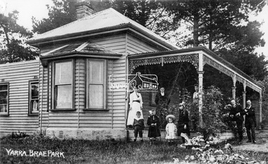 Eltham District Historical Society Inc
Negative - Photograph, Yarra Brae Park, c.1900
Weatherboard house with cast ironwork decoration on the verandah. Three women, two men and four children with rocking horse stand for a photograph. Family unknown. Yarra Brae Park was situated on Yarra Brae Road, off Sweeneys Lane, Eltham. Research in historical newspapers reveals that the Hautrive family lived there 1904-1906, followed by the Bindoon family in 1907. In the 1930s it was occupied by Hubert Rutter, his wife Beulah and four children. Hubert was an Eltham Shire Councillor. On 13 January 1939, the house burned down in the Black Friday bushfires. After the fire, the family relocated to Toorak. Reproduced on p91 of 'Pioneers & Painters'This photo forms part of a collection of photographs gathered by the Shire of Eltham for their centenary project book,"Pioneers and Painters: 100 years of the Shire of Eltham" by Alan Marshall (1971). The collection of over 500 images is held in partnership between Eltham District Historical Society and Yarra Plenty Regional Library (Eltham Library) and is now formally known as 'The Shire of Eltham Pioneers Photograph Collection.' It is significant in being the first community sourced collection representing the places and people of the Shire's first one hundred years.Digital image 4 x 5 inch B&W Neg Sepia postcard and B&W printsepp, shire of eltham pioneers photograph collection, eltham, yarra brae park, verandah, cast iron work, hautrive family, bindoon family, rutter family, pioneers and painters, houses, groups