Showing 945 items
matching dams
-
 Stawell Historical Society Inc
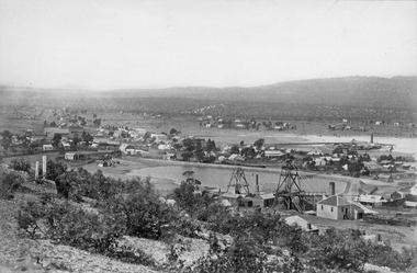
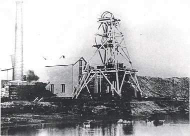
Photograph, Panorama of Stawell Township with Poppet heads & Government Dam, later No2 Reservoir at centre of photo1878
Poppet heads and Government Dam later No2 Reservoir at centre of photo with Black Ranges in background. Stawell East State School on left, Wimmera Battery (also known as Cobb's Battery) on right of photo. 1878. Mr Chaponnel was an Engine Driver on the Battery. No2 West Scotchmans mine on left started in 1873No2 Reservoir in centre of photograph behind two prominent poppet heads. Black Range in right rear of photo. Victorian Views. C. Herbert, Photo. Stawell. 1878stawell mining -
 Bendigo Historical Society Inc.
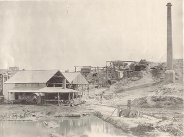
Photograph - GOLD MINE BENDIGO, LAZARUS' CLAIM, C 1860's
Black and white photo: dam in foreground, building and whims on hill in background and tall chimney on rh side. Isolated ( residential ) building on hill at the rear. On front ' Batchelder/Sandhurst' ( not clear ) On back ' Gold mines, Bendigo - probably looking nw along New Chum Hill, with Lazarus' claim in foreground. Phoenix - later Old Chum Mine background'Batchelderorganization, business, lazarus' mine -
 Bendigo Historical Society Inc.
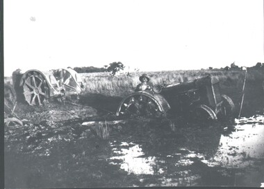
Photograph - HARRY BIGGS COLLECTION: BOGGED TRACTOR
Photograph of a steel wheeled tractor bogged in a dam?, the mud is about two thirds of the way up the rear wheels. There is a man seated on the tractor, there is another steel wheeled tractor with a chain attached to the bogged one. The surrounding country is flat, with some trees in the distance. Written on the back is C. Hercus photo, Glen James bogged in Detroit Fordson Tractor.C. Hercustopic, farming, tractors, detroit fordson tractor, c. hercus, glen james -
 Tatura Irrigation & Wartime Camps Museum
Photograph, 24/3/1917
Taken by photographer for State Rivers and Water Supply Commission.Medium sized black and white photograph. Sugarloaf Reservoir upper core wall, tower, tunnel, and lower dam under construction / Group of men left corner / Rocks in river bed foreground / Horse and cart off-centre left / Horse, cart, and men far right of centre / Words "Diversion Core Wall Tunnel and Riverbed" printed.victorian state rivers and supply commission, sugarloaf reservoir -
 Stawell Historical Society Inc
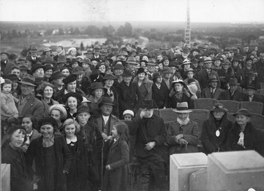
Photograph, Pioneers’ Memorial on Big Hill -- Opening Ceremony Crowd
Opening of Pioneers’ Memorial c 1938. The photo was taken to commemorate the crowd gathering at the opening of the Pioneers' Memorial. To the right in the photo, people are seated, while on the right the majority of the crowd is standing. Black & white photograph of the opening of Pioneers' Memorial c 1938. The photo is taken from the memorial looking down into the crowd. To the right in the photo, you can see the sides of the steps and people seated in cane chairs. On the left side the majority of the crowd is standing. In the background the moonlight dam can be seen plus a ladder leaning against a pole to the right.Opening of Monument on Big Hill. stawell -
 Bendigo Historical Society Inc.
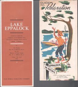
Pamphlet - Lake Eppalock
BHS CollectionTwo small pamphlets. One titled "Guide to relaxation" Eppalock in details compiled and printed offset in Bendigo by Cambridge Press. the other "Lake Eppalock" ceremony to mark the completion of the Eppalock Dam, the Eppalock pumping station and the pipeline to Bendigo; Friday 17 April 1964. Published by the State Rivers and Water Supply Commission. Aileen and John Ellison Collection.lake eppalock, 1964 -
 Bendigo Historical Society Inc.
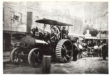
Photograph - BASIL MILLER COLLECTION: PHOTOGRAPHIC COPY OF STEAM TRACTION ENGINE
BHS CollectionBlack and white photo copy of steam traction engine and plough on Pall Mall excavating street for new tram tracks. Note Van Dam's Tobacconist behind the engine. Written on back in blue ink 'Bendigo - Steam Traction Engine and plough in Pall Mall, excavating for new tram track. Copied from ''The Bendigonian'', 2/12/1902'.person, individual, basil miller -
 Bendigo Historical Society Inc.
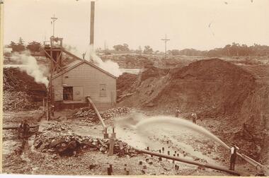
Photograph - AUSTIN COLLECTION: MINE SITE, SLUICING
BHS CollectionBlack and white photo: image shows mine site, chimney in background, corrugated iron shed in middleground, man operating sluice on bottom RH side. Men inside engine house looking on and two beside sluicing operation RH side. Large pile of sand or mullock on RH side. Mining dam in background, barely visible. Unidentified mine.bendigo, mining, mine site -
 Kiewa Valley Historical Society
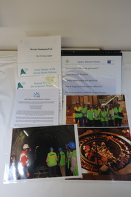
AGL - Bogong Information Centre
AGL took over the operation of the Kiewa Hydro Electric Scheme and constructed the 'Bogong Power Development Project. This involved the construction of a new underground Hydro Electric Power Station on AGL Hydro's Junction Dam regulating pondage near Bogong village in Vctoria's High country. Construction commenced in 2007 and was completed by the end of 2009The Bogong Power Development Project was important to Victoria as hydro power was environmentally friendly. It was important to convey this to the population by way of educating them on the understanding of how it worked and its benefits to providing power to Victoria and beyond.Collection of photos, folders and papers used at the Bogong Information Centre to inform the public on the operation of the Kiewa Hydro Electric Scheme. Dated 2007 - 2009bogong power development project, agl hydro at bogong -
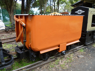 Puffing Billy Railway
Side Tipping Wagon - W. G. Allen & Sons (Tipton) Ltd
Built by W. G. Allen & Sons (Tipton) Ltd., Tipton, Staffordshire, England. This vehicle was used on the construction of dams, etc., and the Jindivick tunnel at Tarago in Gippsland for the state Rivers & Water Supply Commission of Victoria. The small wheel located on the side ran up a suitably located ramp automatically tipping the hopper and emptying the contents. Historic - Industrial Narrow Gauge Railway - side tipping wagon used by the State Rivers & Water Supply Commission of Victoria - Jindivick tunnel at Tarago, Victoria, AustraliaSide Tipping Wagon made of Iron, steel and wrought ironpuffing billy railway, pbr, side tipping wagon - w. g. allen & sons (tipton) ltd, puffing billy, side tipping wagon, w. g. allen & sons (tipton) ltd, jindivick tunnel, state rivers & water supply commission of victoria -
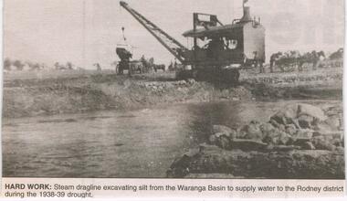 Bendigo Historical Society Inc.
Newspaper - JENNY FOLEY COLLECTION: HARD WORK
Construction of the Waranga Basin initially took place 1905-1915 when it was dug by pick, shovel and horse-drawn scoops. It's embankment was initially 29ft high but over time this was increased to 40 ft. It is an off-river dam that is fed by diversion of water from the Goulbourn River and its aim is to provided irrigation water.Bendigo Advertiser ''The way we were'' from 2003. Hard work: steam dragline excavating silt from the Waranga Basin to supply water to the Rodney district during the 1938-39 drought. The clip is in a folder.newspaper, bendigo advertiser, the way we were -
Hume City Civic Collection
Photograph, Jacksons Creek Viaduct
The four arch railway bridge, known as the Jacksons Creek Viaduct Bridge, spans the Jacksons Creek north of the Sunbury Railway Station. The weir at the base of the bridge was used to dam water as well as ensuring a water supply for the steam trains. The pump house at the base of the bridge was where the water was pumped and then taken to the railway station for the steam engines.This bridge is one of notable four railway bridges along the railway line that are in Sunbury. An enlarged black and white photograph with a white border of a high bridge over a watercourse.bridges, jacksons creek viaduct, jacksons creek viaduct bridge, railways -
 Federation University Historical Collection
Book, Ballarat University College Handbook, 1992, 1992
Ballarat University College was formed in 1990, and is a predecessor organisation of Federation University Australia. Maroon covered book an image of the dam near the Mt Helen swimming pool. Information includes council membership, staff, admission policies and procedures, fees, Aboriginal and Torres Strait Islander Students, Scholarships, accomodation, International Students, courses, units, academic regulations, E.J. Barker Library Regulations, Appeals, Student discipline, Academic Board Policy, Student Union, Enrolment.courses, ballarat university college handbook -
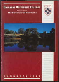
 Federation University Historical Collection
Book, Ballarat University College Handbook, 1993, 1992
Ballarat University College was formed in 1990, and is a predecessor organisation of Federation University Australia. Blue covered book an image of the dam near the Mt Helen swimming pool. Information includes council membership, staff, admission policies and procedures, fees, Aboriginal and Torres Strait Islander Students, Scholarships, accomodation, International Students, courses, units, academic regulations, E.J. Barker Library Regulations, Appeals, Student discipline, Academic Board Policy, Student Union, Enrolment.Jeff Stewart name on first page.courses, ballarat university college handbook, jeff stewart -
 Kiewa Valley Historical Society
Book - Non Fiction History, The Kiewa Story, circa 1993
This book provides in chronological order the development of the Kiewa Hydro-electricity scheme from the first concept (1911) to final construction work (1961). It covers the first attempt to utilise the power of the Victorian Alps water system. It started from a private syndicate and developed to the current State Electricity Commission of Victoria. The incentive for the Hydro scheme was to make money and not as an alternative to the carbon producing coal fired power plants. These coal fired power plants were increasing in numbers to service an ever increasing demand made by population expansion, especially in cities and large rural settlements. This demand spiraled up after World War II when there was a tremendous spike in immigration numbers due to refugees and displaced persons in Europe. The ability to utilise the untapped water provided by the winter snow fields, for a higher yield in electricity, was a powerful incentive to overcome the physical hardships in this remote Alpine region. Future power requirements may initiate the re-installation of the other two power stations(Pretty Valley and Big Hill) covered in original Scheme. This publication not only covers the development of the Kiewa Valley region with respect to population (within a socio-economical framework) but also the subtle but yet strong physical changes of a relatively pristine alpine region. The demands that an ever growing regional population places on the environment is clearly documented in print and black and white photographs. The working and living conditions of those who constructed and gave life to this hydro scheme is well documented in this book. It may be viewed as spartan now but was relevantly good at that moment in time, especially for those workers fleeing a devastated European environment. The successful planning and consideration to minimising any intrusion upon the natural alpine forests and high plains can viewed as an example (compared to the Tasmanian Hydro schemes) of how future hydro schemes (an inevitable requirement) will proceed. Most rural towns (in the early 1900s) were built by unencumbered rural based citizens, with the exception of Mount Beauty and Falls Creek. These two settlements were brought into life by a State (Victorian) Authority for a specific function and program. They were a gated community, that is, only open to construction workers involved with the hydro scheme. All facilities within these communities were provided by the State Electricity Commission of Victoria. The impact on the social, financial and individual independency of the community, by the transition from the S.E.C .environment to one of local government (Shire of Bright), had in some cases a severe impact.This hard covered book has a green cover with pictures on the front and back covers. The front cover has a coloured picture of a snow covered Mount Bogong taken from the opposite mountain range. The valley between both ranges has a whisk of mist over it. At the bottom of this picture are three black and white photographs covering the construction of the Kiewa Hydro - Electricity Scheme. On the back cover is a photograph, (black and white) detailing the Bogong village and Junction dam containing lake Guy. The inside front cover is a black and white photograph which details the construction of the West Kiewa tailrace tunnel during April 1951. The inside back cover is a black and white photograph of the concrete pour at the Clover Dam circa 1952. All photographs and sketches are in black and white. The pages are approximately 160 g/m2 and those which have photographs are on gloss paper.Book spine: "The Kiewa Story Graham Napier Geoff Easdown" alongside this is a white framed circle with white spokes radiating out and underneath in white lettering SECkiewa valley, hydro scheme, victorian alpine region, electricity generators, graham napier, geoff easdown -
 Kiewa Valley Historical Society
Photograph - Folder of Photographs – Photocopied set of black and white photographs (pages 39 - 48) from the display folder put together by KVHS to document life on the Kiewa Valley Hydro-electric Scheme
Although the Kiewa Hydro-Electric Scheme was first proposed in 1911, construction did not commence until 1938. As part of the push to cut electricity costs and diversify supply, the Victorian Government (circa 1930) initiated the conversion from primarily brown coal supply to hydro – electricity. Field investigations during the 1940’s resulted in a new proposal for a scheme that had more than double the capacity of the 1938 scheme. The Kiewa Hydroelectric Scheme became the largest scheme of its kind in the State Of Victoria and the second largest scheme in Australia. The number of personnel involved in the planning and construction of the scheme increased dramatically. During the late 1940’s, most activity centered around the construction of the West Kiewa Power Station, Rocky Valley Reservoir, McKay Creek Power Station and the Bogong Creek Aqueduct.A common thread across all the larger hydro scheme constructions was the need for workers, both qualified and unqualified who came from around the world seeking a new life for themselves and their families. New accommodation and facilities were required for the army of workers engaged in construction in often remote and wild areas. The SEC had a high demand for timber, and set up the first of a number of sawmills at Bogong Creek in 1939 and set up the first hardwood logging in the headwaters of the Kiewa River. These new ‘towns’ such as Mt Beauty and Bogong, survived, serving the needs of operational personnel and their families, and expanding with growth of new industries. Mount Beauty, and to a lesser extent Bogong, are among these places. Large A3 size spiral bound display folder containing photocopied black and white photographs of various aspects of the early days of the Kiewa Valley Hydro-electric scheme including equipment, various work sites and photographs of workers and their families. 1-Breakdown in Circuit Breaker (Isolating Contacts) 2-Big Hill Bench- Site of No 5 Devlopment 3-No 1 Power Station 4-No 1 Pipeline, Anchor No 8 5-Push Dozing-RD8 Tractor 6- Tractor and driver at work 7- Workmen in unnamed tunnel 8- Front page of Journal of SECV Vol 15. Photograph of No 1 pipeline viewed from McKay Portal 9-Rocky Valley Dam Core Wall 10-Workmen working inside tunnel loading rocks into a rail truck. 1-Breakdown in (generator) Circuit Breaker (Isolating Contacts) Handwritten underneath (This is not a picture of any part of a generator. It is a circuit breaker Signed Ron White Ron was the Principal Hydro Engineer of the SEC Kiewa Scheme Page number 39 2-Big Hill Bench – Site of No. 5 Development (abandoned) Page number 40 3-No 1 Power Station Page number 41 4-No. 1 Pipeline, Anchor No. 8 Page number 42 5-Push Dozing – RD8 Tractor, 12 cubic yard Carryall and FD Cletrac Tractor Page number 43 6-No marking Page number 44 7-No marking Page number 45 8-Journal of State Electricity Commission of Victoria SEC Vol 15 No… April-May, 19… No 1 Pipeline-A view from McKay Portal G Hempenstall and D Sutton stiffening pipe section for transport during construction (….indicates missing text) Page Number 46 9-Rocky Valley Dam Core Wall Page number 47 10-No markings Page number 48 secv; kiewa hydro electric scheme; construction area; power stations; reservoirs; aqueduct; mt beauty; bogong -
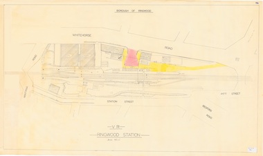 Ringwood and District Historical Society
Plan, Borough of Ringwood - VR Ringwood Station - Circa 1930s
Technical drawing of Ringwood Railway Station features, surrounding streets and buildings including Cool Stores, Packing Shed, Coke Bin, Coal Box, Dam, Garage, Shops, ES&A Bank, Station Master's Residence, Drill Hall, Goods Shed, Signal Box, Passenger Platform, Footbridge, and Clock Tower at Warrandyte Road. Station entrance and traffic access areas shaded red and yellow.Scale: 1"=40' -
 Bendigo Historical Society Inc.
Photograph - LONG GULLY HISTORY GROUP COLLECTION: HERCULES/ENERGETIC MINE
Black and white photocopy of the Hercules/Energetic Mine. The photo shows the poppet legs, mine building and brick chimney. There is also heaps of tailings. In the foreground is a dam, with what looks like ducks/geese on it. Written on the back: One of the mines that Sir John Quick worked in. He used to drive a Horse Whim. Hercules / Energetic Mine. Energetic Mine first then amalgamated to H/E.bendigo, history, long gully history group, the long gully history group - hercules/energetic mine, sir john quick -
Bendigo Historical Society Inc.
Document - SONOGNINI MINING LEASE
Mining lease between Leno Sonognini of Victoria Street Eaglehawk, Miner and Giovanni Sonognini. Three acres, three roods 9 perches with a mining dam. On lease document: Leno Sonognini ..... Is now the proprietor of the within described lease by transfer from the within named Giovanni Sonognini' Dated '10th day of February 1898 at 12.20 in the afternoon and numbered 60701 Mining lease No 5956'.bendigo, mining, lease 5956, eaglehawk -
Bendigo Historical Society Inc.
Map - MAP WHITE HILL TO HUNTLY
Map of Bendigo creek and adjacent leads - White Hills to Huntly replotted from old 4 chain to 1 inch survey of 1860 by G. W. Hart - Surveyor. Base of roads and streets taken from D.L.S. 1 . 10000 base maps. Legend: battery site, puddling mill site, dam bank site, cutting altering course of creek, lead boundaries.bendigo, mining -
 Wodonga & District Historical Society Inc
Album - Hume Reservoir Australia Album - View of site on 28th November 1919, 1927
This set of photos is from a leather bound album bearing the inscription "HUME RESERVOIR AUSTRALIA" plus 'The Rt. Hon. L. C. M. S. Amery, P. C., M .P.' all inscribed in gold. It was presented to The Rt. Hon. L. C. M. S. Amery, P. C., M. P, Secretary of State for Dominion Affairs on the occasion of his visit to the Hume Reservoir on 2nd November 1927. This album is of local and national significance as it documents the planning and development of the Hume Reservoir up to 1927. It was the largest water reservoir in the British Empire. The album records the pioneering engineering work that went into its construction.DEPARTMENT OF PUBLIC WORKS, N.S.W. RIVER MURRAY WATERS SCHEME. HUME RESERVOIR. 3. View of site on 28th November 1919 when the first sod was turned by the Governor General Sir Ronald Munro Ferguson, now Lord Hovar. The view is taken from the New South Wales end of the dam looking across the Murray to Victoria. The Murray flows from left to right.hume reservoir australia, river murray waters scheme, hume weir diagrams, hume plan details -
 Melbourne Legacy
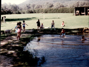
Photograph - Junior legatee outing, Farm visit, 198
Legacy have many programs to send young junior legatees on activities, camps and outings. The photos shows a group of junior legatees outdoors on a farm. In one they are swimming in a dam, in another they are walking and the other is of a campfire. They appear to be the same camp (03170 and 03172). The date is not known though the smaller photo size might mean it is from the 1980s or 1990s, and were stored with other photos of Junior Legatees. A record of a Legacy providing experiences for the junior legatees.Colour photo x 3 of a group of junior legatees outdoors on a farm.junior legatee outing, camp, farm -
 Kiewa Valley Historical Society
Maps - Educational x 10 and Kiewa Scheme x1
Maps were used to teach children geography, the explorers, the minerals, the world etc. The school bought and stored the maps so that they were available for use. This predated electronic devices. The KHE Works map was hand drawn showing lots of detail.These maps were used by the Bogong Primary School. The Kiewa Hydro Electric Works was built by the SECV and produced hydro power. This map may have been used by pupils as well as workers on the Works. Large coloured maps on canvas, with a wooden beam along the top and bottom. Each one has a cord attached to the top so that the map may be hung up on a wall. Some are made by Chas. H. Scally & Co., Baronia Ave., Wollstonecraft, N.S.W. The Kiewa Hydro Electric Works map is pinkish and shows Rocky Valley Dam, Lake Guy and Mt Beauty pondage in dark blue.maps, educational maps, geography, primary school, kiewa hydro electric works -
 Bendigo Historical Society Inc.
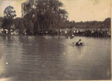
Photograph - PHOTOGRAPH: LAKE WEEROONA BENDIGO
Sepia photograph mounted on board. Image shows large group of people standing on side of lake watching young men paddling in tub like boats. Man in foreground in boat has white skin down to sleeve mark, very tanned arms. Large willow tree in middle, slab fence behind onlookers. Uncertain of location, could be large dam, no buildings evident in background of image.event, recreation, bendigo, recreation, lake, dam. -
 Hume City Civic Collection
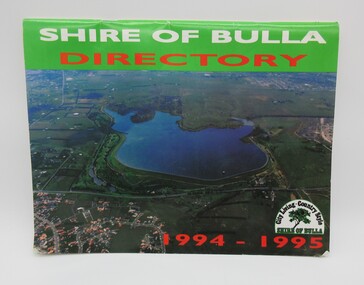
Directory, Shire of Bulla Directory, 1994 - 1995
The Directory was published by the former Shire of Bulla in 1994 - 1995 and was issued to residentsa living withing the Shire. It features details of public services which were available within the area at the time as well as maps of the settlements and some private advewrtisements.A 20 page booklet with an aerial photograph of the Greenvale Dam and surrounding area on the front cover. A green strip is along the spine of the booklet with the words 'Shire of Bulla' printed in white and 'Directory' printed in red. '1994 - 1995' is printed in red across the bottom of the front cover and the Shire of Bulla - 'City Living . Country Style' logo is in the bottom RH corner. The back cover features an advertisement for the Roxburgh housing development.shire of bulla, directory, sunbury, bulla, attwood hill, craigieburn, george evans collection -
 Kiewa Valley Historical Society
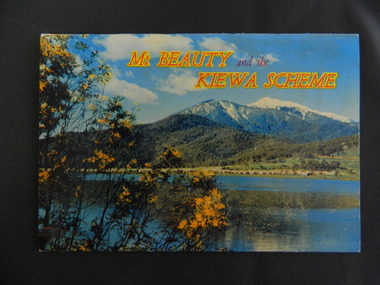
Booklet - Mt Beauty and the Kiewa Scheme x2
This booklet was produced to advertise Mt Beauty, the Kiewa Scheme & surrounding areas to visitors / tourists. The photos cover Falls Creek with snow, lifts and skiers - one with Spion Kopje Lodge. Also Tawonga Camping ground, Bogong Village, Mt Beauty Chalet, the Control panel at Kiewa Power Station, Clover Dam at No. 3 Power Station, the road to Falls Creek and a view of Mt Beauty township. The photos indicate what Mt Beauty and the Kiewa Valley and High Plains looked like c1950's during the construction of the Kiewa Hydro Electric Scheme. The area was recognised and encouraged as a tourist attraction especially Falls Creek enabling comparison with later photos and ideas. A fold down booklet postcard size of 12 colored photos - back to back of Mt Beauty, the Kiewa Scheme & surrounds. They fold in to form a front photo with title and a back card for stamp & address of addressee. On the back of the front photo are a few paragraphs describing the beauty, history and 'things to do' in the area for the visitor / tourist. mt beauty; kiewa scheme; tawonga; bogong; clover dam; kiewa valley; bogong high plains -
 Bendigo Historical Society Inc.
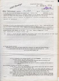
Document - MCCOLL, RANKIN AND STANISTREET COLLECTION: INDENTURE NORTH DEBORAH MINING COMPANY, 20th November, 1952
6 page document ' Gold Mining Lease Crown land Number 11307 Bendigo' plus map. Indenture document between Queen Elizabeth 11 and North Deborah Mining Company No Liability, Parish of Sandhurst, dated 20th November, 1952 re Vol 333, Folio 053. Land indicated by yellow on map and below ' a depth of one hundred and fifty feet from the surface of the land indicated by purple colour and delineated on the plan' Document signed by J. Stanistreet, Manager, North Deborah Mining Company No Liability. Map, fixed to document, heading ' Mining District of Bendigo, No. 11307, County of Bendigo, Parish of Sandhurst, Total area 13 acres 2 roods, 11 perches. Map shows large dam on Crown land, transmission line excised 150 ft., written on purple area. Underneath map ' provided that the dam indicated on the said plan is hereby reserved'.bendigo, mining, north deborah mining company -
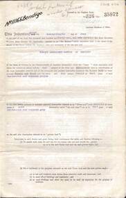 Bendigo Historical Society Inc.
Document - MCCOLL, RANKIN AND STANISTREET COLLECTION: INDENTURE, GOLD MINING LEASE CROWN AND RONALD ALEXANDER RANKIN, BENDIGO, 24th June 1941
6 page document, Gold Mining Lease 11166, plus map. Indenture between Crown (King George VI) and Ronald Alexander Rankin of Bendigo, dated 24th June, 1941. Map No. 11166 Bendigo, Mining District of Bendigo, Parish of Sandhurst, County of Bendigo. Map shows lease 11166 marked in yellow with shaft, ore bins and tramway marked. Belle Vue Road , Adam Street and Griston Street shown on map. ( Golden Gully area) Dams indicated on lease holdings. Other lease holdings: 1675 T.L.9858, 10990, 11013, 11062, 11165, 11063 (void) 1172 W.R. (dam thereon) 9882 (void). Some residential lots marked along Belle Vue Road, and Adam Street. On bottom of map 21.8.41 in pencil. On last page of document : North Deborah Mining Company now the proprietor of the within described estate by transfer registered on 11th November 1914.bendigo, mining, north deborah lease, belle vue road, adams street, griston street, golden gully, ronald alexander rankin, north deborah mine. -
 Flagstaff Hill Maritime Museum and Village
Book, William Dampier
This item is from the ‘Pattison Collection’, a collection of books and records that was originally owned by the Warrnambool Mechanics’ Institute, which was founded in Warrnambool in 1853. By 1886 the Warrnambool Mechanics’ Institute (WMI) had grown to have a Library, Museum and Fine Arts Gallery, with a collection of “… choice productions of art, and valuable specimens in almost every branch and many wonderful national curiosities are now to be seen there, including historic relics of the town and district.” It later included a School of Design. Although it was very well patronised, the lack of financial support led the WMI in 1911 to ask the City Council to take it over. In 1935 Ralph Pattison was appointed as City Librarian to establish and organise the Warrnambool Library as it was then called. When the WMI building was pulled down in 1963 a new civic building was erected on the site and the new Warrnambool Library, on behalf of the City Council, took over all the holdings of the WMI. At this time some of the items were separated and identified as the ‘Pattison Collection’, named after Ralph Pattison. Eventually the components of the WMI were distributed from the Warrnambool Library to various places, including the Art Gallery, Historical Society and Flagstaff Hill. Later some were even distributed to other regional branches of Corangamite Regional Library and passed to and fro. It is difficult now to trace just where all of the items have ended up. The books at Flagstaff Hill Maritime Village generally display stamps and markings from Pattison as well as a variety of other institutions including the Mechanics’ Institute itself. RALPH ERIC PATTISON Ralph Eric Pattison was born in Rockhampton, Queensland, in 1891. He married Maude Swan from Warrnambool in 1920 and they set up home in Warrnambool. In 1935 Pattison accepted a position as City Librarian for the Warrnambool City Council. His huge challenge was to make a functional library within two rooms of the Mechanics’ Institute. He tirelessly cleaned, cleared and sorted a disarrayed collection of old books, jars of preserved specimens and other items reserved for exhibition in the city’s museum. He developed and updated the library with a wide variety of books for all tastes, including reference books for students; a difficult task to fulfil during the years following the Depression. He converted all of the lower area of the building into a library, reference room and reading room for members and the public. The books were sorted and stored using a cataloguing and card index system that he had developed himself. He also prepared the upper floor of the building and established the Art Gallery and later the Museum, a place to exhibit the many old relics that had been stored for years for this purpose. One of the treasures he found was a beautiful ancient clock, which he repaired, restored and enjoyed using in his office during the years of his service there. Ralph Pattison was described as “a meticulous gentleman whose punctuality, floorless courtesy and distinctive neat dress were hallmarks of his character, and ‘his’ clock controlled his daily routine, and his opening and closing of the library’s large heavy doors to the minute.” Pattison took leave during 1942 to 1945 to serve in the Royal Australian Navy, Volunteer Reserve as Lieutenant. A few years later he converted one of the Museum’s rooms into a Children’s Library, stocking it with suitable books for the younger generation. This was an instant success. In the 1950’s he had the honour of being appointed to the Victorian Library Board and received more inspiration from the monthly conferences in Melbourne. He was sadly retired in 1959 after over 23 years of service, due to the fact that he had gone over the working age of council officers. However he continued to take a very keen interest in the continual development of the Library until his death in 1969. The Pattison Collection, along with other items at Flagstaff Hill Maritime Village, was originally part of the Warrnambool Mechanics' Institute’s collection. The Warrnambool Mechanics’ Institute Collection is primarily significant in its totality, rather than for the individual objects it contains. Its contents are highly representative of the development of Mechanics' Institute libraries across Australia, particularly Victoria. A diversity of publications and themes has been amassed, and these provide clues to our understanding of the nature of and changes in the reading habits of Victorians from the 1850s to the middle of the 20th century. The collection also highlights the Warrnambool community’s commitment to the Mechanics’ Institute, reading, literacy and learning in the regions, and proves that access to knowledge was not impeded by distance. These items help to provide a more complete picture of our community’s ideals and aspirations. The Warrnambool Mechanics Institute book collection has historical and social significance for its strong association with the Mechanics Institute movement and the important role it played in the intellectual, cultural and social development of people throughout the latter part of the nineteenth century and the early twentieth century. The collection of books is a rare example of an early lending library and its significance is enhanced by the survival of an original collection of many volumes. The Warrnambool Mechanics' Institute’s publication collection is of both local and state significance. William Dampier Author: W Clark Russell Publisher: MacMillan & Co Date: 1889 Label on spine cover with typed text PAT 920 DAM Pastedown front endpaper has sticker from Warrnambool Mechanics Institute and Free Library covered by a sticker from Corangamite Regional Library Service Front loose endpaper has a stamp from Corangamite Regional Library Servicewarrnambool, shipwrecked-coast, flagstaff-hill, flagstaff-hill-maritime-museum, maritime-museum, shipwreck-coast, flagstaff-hill-maritime-village, shipwrecked-artefact, book, pattison collection, warrnambool library, warrnambool mechanics’ institute, ralph eric pattison, corangamite regional library service, warrnambool city librarian, mechanics’ institute library, victorian library board, warrnambool books and records, warrnambool children’s library, great ocean road, william dampier, w clark russell -
 Federation University Historical Collection
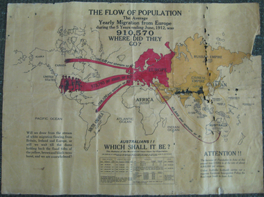
Poster, The Flow of Population, c1920
This posters advertises reasons for the migration of European (or white) people to Australia.Coloured poster on canvas showing the flow of World population around 1920 from Europe to Australia, Canada, the United States of America and South America. The poster appears to be pro the White Australia Policy with statements such as 'Will we draw from the stream of white migration from Britain, Ireland and Europe, or will we wait til the dams holding back the flood tides of the yellow, brown and black races burst, and we are overwhelmed?'migration, population, race, population statistics, migrations statistics, european immigration policy, white australia policy, racism, immigration, poster