Showing 1066 items matching "over the river"
-
 Orbost & District Historical Society
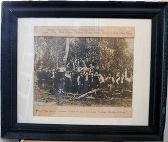
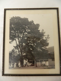
black and white photograph, late 19th century - early 20th century
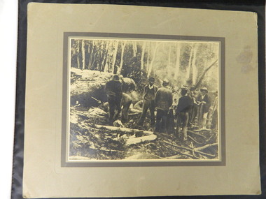
The local logging industry had its beginning back in 1882. The first batch of timber was cut in a sawmill at Orbost on the Brodribb River.Orbost has historically been based on the timber industry, but that industry has declined considerably over the last 20 years. The number of locals involved in the timber industry has declined and many of the mills have closed. This item reflects a time when that industry was a significant contributor to the economy of the district.A very large framed black / white photograph of a large group of timber workers in a bush setting. Above and below the photograph are their names. The names can be clearly read. The photograph is on a white buff card under glass in a black frame.Names are type - written above and below the photograph.timber-industry -
 Orbost & District Historical Society
black and white photographs, Snowy River Mail, March 12 1980
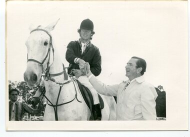
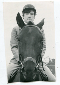
These photographs were taken at the 1980 annual Orbost Show. The first photograph is of Mr Frank Rourke congratulating Combienbar rider, Gavin Chester, East Gippsland Olympian ( a member of the 1980 Australian team which did not compete in Moscow). He won the title of Champion Show Jumper riding his mount "Blue Trick" on Monday March 10 1980. The second photograph shows Mr Frank Rourke placing the winning ribbon around the neck of Gavin Chester's winning mount, "Blue Trick" The third photograph is the winner of the coveted R.L.Fisher Memorial Plate won by Eric Musgrave being congratulated by Mr Frank Rourke. Frank Rourke was the Gippsland and Northern manager. G. & N. sponsored the event which carried a prize of $500. On the left in this photograph is Mr J. Horstman, ring four judge.This is a pictorial record of a significant event in Orbost. This item is also associated with the Orbost Agricultural Society 's Annual Show which has been a major event in Orbost for over a century. Agricultural shows are an important part of cultural life in small country towns and the Orbost Show is an integral part of Orbost 's agricultural history.Three black / white photographs of a rider on horseback receiving congratulations. There are details on labels on the back of each photograph.orbost-show equestrian chester-gavin musgrave-eric show-jumping -
 Orbost & District Historical Society
photographs, Snowy River Mail, C1968
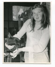
These photographs were probably published in the Snowy River Mail. Some of the Orbost identities in the photographs are: Jim Holden; Brian Morgan; Clarrie Ingram; Jeffrey Fecondo; David Holden; Brian Holden; Richard Morgan; Sue Joiner and Charlie Owen. They were taken in the Poultry Shed at the Orbost Show at the Newmerella Showground. The first meeting to form an Agricultural society in Orbost was convened by the then Orbost Progress Association and held in the Mechanics Hall on Saturday, 10th October 1891. Its first show was held on 3rd March 1904...on a site alongside the Bonang Road where the present Golf Club stands. It is currently held at the Recreation Reserve at Newmerella. (Ref: In Times Gone By-Deborah Hall)These photographs are associated with the Orbost Agricultural Society 's Annual Show which has been a major event in Orbost for over a century. Agricultural shows are an important part of cultural life in small country towns and the Orbost Show is an integral part of Orbost 's agricultural history.Twenty-two black / white photographs and four coloured photographs. all are related to the Orbost Agricultural Show.poultry agriculture-show-orbost -
 Orbost & District Historical Society
black and white photographs, Snowy River Mail, 1960s
These photographs were taken at the annual Orbost Agricultural Show at the Newmerella Showground. They were probably published in the Snowy River Mail newspaper. Some of the Orbost identities pictured include : Russell Crofts, Kevin McDonald, Brian McDonald, Gail & Lee Winchester, Julie & Lisa Drummond, Marion Russell, Sylvia MurrayRod Kleinitz, Rober Morgan, Trevor Perry, Brian Woodlands, anna light, Louella Brunt, Colin Weir, Wendy Pinnock, Raeleen Reed, Margaret Joiner and Jo-anne Mundy. The first meeting to form an Agricultural society in Orbost was convened by the then Orbost Progress Association and held in the Mechanics Hall on Saturday, 10th October 1891. Its first show was held on 3rd March 1904...on a site alongside the Bonang Road where the present Golf Club stands. It is currently held at the Recreation Reserve at Newmerella. (Ref: In Times Gone By-Deborah Hall)These photographs are associated with the Orbost Agricultural Society 's Annual Show which has been a major event in Orbost for over a century. Agricultural shows are an important part of cultural life in small country towns and the Orbost Show is an integral part of Orbost 's agricultural history. Seventeen black / white phootgraphs which were taken at the Orbost Agricultural Show.orbost-agricultural-show -
 Orbost & District Historical Society
black and white photographs, Snowy River Mail, August 21 1987
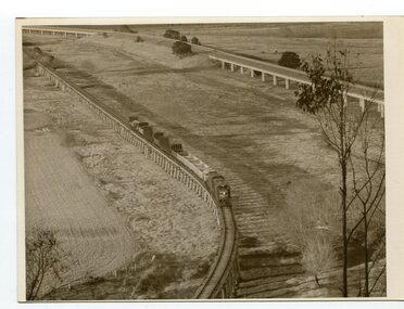
These photographs are from the Snowy River Mail newspaper, September 9, 1987. Ron Hayward's family ran a shop in Rupert Street, Orbost.This item is associated with the history of the Orbost-Bairnsdale railway line and therefore reflects the role that the rail line played in the social and economic history of Orbost. The closure of the line was a significant event in Orbost's history.Five black / white photographs related to closure of the Orbost - Bairnsdale Railway Line.3104.1 - on back - "A view from Grandview, Newmerella, of the last train to leave Orbost on Friday August 21, 1987. As the afternoon sun lengthens the shadows on the Snowy River flats, the sun also sets on an era in Far East Gippsland transport as the last train crosses the viaduct." 3104,2 - 0n back - "Ron Hayward passes over the staff during the last crew changeover for the last train to run on the Orbost line. Ron Haywood (L) who 39 years and 6 months ago drove the first diesel loco to Orbost (T366T) presents the last staff to the driver, Bill Buckley, who took the last diesel out." 3104.3 - on back -" as above - 2nd paragraph only 3104.4 - on back - " Ron Hayward who took the first diesel engine from Bairnsdale to Orbost on February 21. 1957 when he was stationed at Orbosst. Last Friday he rode on the last diesel to Orbost after obtaining a special pass from V Line , he also handed over the staff for the last change at Orbost. The last driver was Bill Buckley." 3104.5 - on back - "LAST TRAIN ROLLS INTO ORBOST B/A Friday August 28 1987 For Ron Hayward the last train journey on the Orbost rail line was a sad occasion. Mr Hayward took the first diesel engine from Bairnsdale to Orbost on February 21, 1957, whe he was stationed at Orbost. Last Friday he rode on the last diesel too Orbost after obtaining a special pass from V-Line. He also handed over the staff for the last change at Orbost. The last driver was Bill Buckley. Mr Hayward was an engine driver with nhe railways and transferred to Orbost when steam engines used the line. He left the railways in in 1957 but took up a job with them again in 1968. He said also it was a privilege to have been able to ride on the last train, the occasion was a sad one,"east-gippsland-railway railway-closure hayward-ron buckley-bill orbost-bairnsdale-railway -
 Flagstaff Hill Maritime Museum and Village
Cap Liner
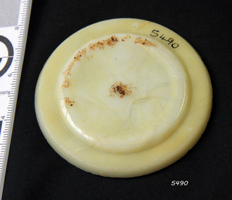
The iron-hulled, four-masted barque, the Falls of Halladale, was a bulk carrier of general cargo. She left New York in August 1908 on her way to Melbourne and Sydney. In her hold, along with 56,763 tiles of unusual beautiful green American slates (roofing tiles), 5,673 coils of barbed wire, 600 stoves, 500 sewing machines, 6500 gallons of oil, 14400 gallons of benzene, and many other manufactured items, were 117 cases of crockery and glassware. Three months later and close to her destination, a navigational error caused the Falls of Halladale to be wrecked on a reef off the Peterborough headland at 3 am on the morning of the 15th of November, 1908. The captain and 29 crew members all survived, but her valuable cargo was largely lost, despite two salvage attempts in 1908-09 and 1910. ABOUT THE ‘FALLS OF HALLADALE’ (1886 - 1908) Built: in1886 by Russell & Co., Greenock shipyards, River Clyde, Scotland, UK. The company was founded in 1870 (or 1873) as a partnership between Joseph Russell (1834-1917), Anderson Rodger and William Todd Lithgow. During the period 1882-92 Russell & Co., standardised designs, which sped up their building process so much that they were able to build 271 ships over that time. In 1886 they introduced a 3000 ton class of sailing vessel with auxiliary engines and brace halyard winches. In 1890 they broke the world output record. Owner: Falls Line, Wright, Breakenridge & Co, 111 Union Street, Glasgow, Scotland. Configuration: Four masted sailing ship; iron-hulled barque; iron masts, wire rigging, fore & aft lifting bridges. Size: Length 83.87m x Breadth 12.6m x Depth 7.23m, Gross tonnage 2085 ton Wrecked: the night of 14th November 1908, Curdies Inlet, Peterborough south west Victoria Crew: 29 The Falls of Halladale was a four-masted sailing ship built-in 1886 in Glasgow, Scotland, for the long-distance cargo trade and was mostly used for Pacific grain trade. She was owned by Wright, Breakenridge & Co of Glasgow and was one of several Falls Line ships, all of which were named after waterfalls in Scotland. The lines flag was of red, blue and white vertical stripes. The Falls of Halladale had a sturdy construction built to carry maximum cargo and able to maintain full sail in heavy gales, one of the last of the ‘windjammers’ that sailed the Trade Route. She and her sister ship, the Falls of Garry, were the first ships in the world to include fore and aft lifting bridges. Previous to this, heavily loaded vessels could have heavy seas break along the full length of the deck, causing serious injury or even death to those on deck. The new, raised catwalk-type decking allowed the crew to move above the deck stormy conditions. This idea is still used today on the most modern tankers and cargo vessels and has proved to be an important step forward in the safety of men at sea. On 4th August 1908, with new sails, 29 crew, and 2800 tons of cargo, the Falls of Halladale left New York, bound for Melbourne and Sydney via the Cape of Good Hope. The cargo on board was valued at £35,000 and included 56,763 tiles of American slate roofing tiles (roof slates), 5,673 coils of barbed wire, 600 stoves, 500 sewing machines, 6,500 gallons of oil, 14,400 gallons of benzene, plumbing iron, 117 cases of crockery and glassware and many other manufactured items. The Falls of Halladale had been at sail for 102 days when, at 3 am on the night of 14th November 1908, under full sail in calm seas with a six knots breeze behind and misleading fog along the coast, the great vessel rose upon an ocean swell and settled on top of a submerged reef near Peterborough on the south-west Victoria’s coast. The ship was jammed on the rocks and began filling with water. The crew launched the two lifeboats and all 29 crew landed safely on the beach over 4 miles away at the Bay of Islands. The postmistress at Peterborough, who kept a watch for vessels in distress, saw the stranding and sent out an alert to the local people. A rescue party went to the aid of the sailors and the Port Campbell rocket crew was dispatched, but the crew had all managed to reach shore safely by the time help arrived. The ship stayed in full sail on the rocky shelf for nearly two months, attracting hundreds of sightseers who watched her slowly disintegrate until the pounding seas and dynamiting by salvagers finally broke her back, and her remains disappeared back into deeper water. The valuable cargo was largely lost, despite two salvage attempts in 1908-09 and 1910. Further salvage operations were made from 1974-1986, during which time 22,000 slate tiles were recovered with the help of 14 oil drums to float them, plus personal artefacts, ship fittings, reams of paper and other items. The Court of Marine Inquiry in Melbourne ruled that the foundering of the ship was entirely due to Captain David Wood Thomson’s navigational error, not too technical failure of the Clyde-built ship. The shipwreck is a popular site for divers, about 300m offshore and in 3 – 15m of water. Some of the original cargo can be seen at the site, including pieces of roof slate and coils of barbed wire. The Falls of Halladale shipwreck is listed on the Victorian Heritage Register (No. S255). She was one of the last ships to sail the Trade Routes. She is one of the first vessels to have fore and aft lifting bridges. She is an example of the remains of an International Cargo Ship and also represents aspects of Victoria’s shipping industry. The wreck is protected as a Historic Shipwreck under the Commonwealth Historic Shipwrecks Act (1976).Alabaster milk jar lid insert. Has a chip on the side. Recovered from the Falls of Halladale.flagstaff hill, warrnambool, shipwrecked coast, flagstaff hill maritime museum, maritime museum, shipwreck coast, flagstaff hill maritime village, great ocean road, falls of halladale, shipwreck peterborough, 1908 shipwreck, great clipper ships, russell & co., cap liner -
 Flagstaff Hill Maritime Museum and Village
Cap Liner
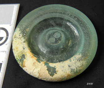
The iron-hulled, four-masted barque, the Falls of Halladale, was a bulk carrier of general cargo. She left New York in August 1908 on her way to Melbourne and Sydney. In her hold, along with 56,763 tiles of unusual beautiful green American slates (roofing tiles), 5,673 coils of barbed wire, 600 stoves, 500 sewing machines, 6500 gallons of oil, 14400 gallons of benzene, and many other manufactured items, were 117 cases of crockery and glassware. Three months later and close to her destination, a navigational error caused the Falls of Halladale to be wrecked on a reef off the Peterborough headland at 3 am on the morning of the 15th of November, 1908. The captain and 29 crew members all survived, but her valuable cargo was largely lost, despite two salvage attempts in 1908-09 and 1910. ABOUT THE ‘FALLS OF HALLADALE’ (1886 - 1908) Built: in1886 by Russell & Co., Greenock shipyards, River Clyde, Scotland, UK. The company was founded in 1870 (or 1873) as a partnership between Joseph Russell (1834-1917), Anderson Rodger and William Todd Lithgow. During the period 1882-92 Russell & Co., standardised designs, which sped up their building process so much that they were able to build 271 ships over that time. In 1886 they introduced a 3000 ton class of sailing vessel with auxiliary engines and brace halyard winches. In 1890 they broke the world output record. Owner: Falls Line, Wright, Breakenridge & Co, 111 Union Street, Glasgow, Scotland. Configuration: Four masted sailing ship; iron-hulled barque; iron masts, wire rigging, fore & aft lifting bridges. Size: Length 83.87m x Breadth 12.6m x Depth 7.23m, Gross tonnage 2085 ton Wrecked: the night of 14th November 1908, Curdies Inlet, Peterborough south west Victoria Crew: 29 The Falls of Halladale was a four-masted sailing ship built-in 1886 in Glasgow, Scotland, for the long-distance cargo trade and was mostly used for Pacific grain trade. She was owned by Wright, Breakenridge & Co of Glasgow and was one of several Falls Line ships, all of which were named after waterfalls in Scotland. The lines flag was of red, blue and white vertical stripes. The Falls of Halladale had a sturdy construction built to carry maximum cargo and able to maintain full sail in heavy gales, one of the last of the ‘windjammers’ that sailed the Trade Route. She and her sister ship, the Falls of Garry, were the first ships in the world to include fore and aft lifting bridges. Previous to this, heavily loaded vessels could have heavy seas break along the full length of the deck, causing serious injury or even death to those on deck. The new, raised catwalk-type decking allowed the crew to move above the deck stormy conditions. This idea is still used today on the most modern tankers and cargo vessels and has proved to be an important step forward in the safety of men at sea. On 4th August 1908, with new sails, 29 crew, and 2800 tons of cargo, the Falls of Halladale left New York, bound for Melbourne and Sydney via the Cape of Good Hope. The cargo on board was valued at £35,000 and included 56,763 tiles of American slate roofing tiles (roof slates), 5,673 coils of barbed wire, 600 stoves, 500 sewing machines, 6,500 gallons of oil, 14,400 gallons of benzene, plumbing iron, 117 cases of crockery and glassware and many other manufactured items. The Falls of Halladale had been at sail for 102 days when, at 3 am on the night of 14th November 1908, under full sail in calm seas with a six knots breeze behind and misleading fog along the coast, the great vessel rose upon an ocean swell and settled on top of a submerged reef near Peterborough on the south-west Victoria’s coast. The ship was jammed on the rocks and began filling with water. The crew launched the two lifeboats and all 29 crew landed safely on the beach over 4 miles away at the Bay of Islands. The postmistress at Peterborough, who kept a watch for vessels in distress, saw the stranding and sent out an alert to the local people. A rescue party went to the aid of the sailors and the Port Campbell rocket crew was dispatched, but the crew had all managed to reach shore safely by the time help arrived. The ship stayed in full sail on the rocky shelf for nearly two months, attracting hundreds of sightseers who watched her slowly disintegrate until the pounding seas and dynamiting by salvagers finally broke her back, and her remains disappeared back into deeper water. The valuable cargo was largely lost, despite two salvage attempts in 1908-09 and 1910. Further salvage operations were made from 1974-1986, during which time 22,000 slate tiles were recovered with the help of 14 oil drums to float them, plus personal artefacts, ship fittings, reams of paper and other items. The Court of Marine Inquiry in Melbourne ruled that the foundering of the ship was entirely due to Captain David Wood Thomson’s navigational error, not too technical failure of the Clyde-built ship. The shipwreck is a popular site for divers, about 300m offshore and in 3 – 15m of water. Some of the original cargo can be seen at the site, including pieces of roof slate and coils of barbed wire. The Falls of Halladale shipwreck is listed on the Victorian Heritage Register (No. S255). She was one of the last ships to sail the Trade Routes. She is one of the first vessels to have fore and aft lifting bridges. She is an example of the remains of an International Cargo Ship and also represents aspects of Victoria’s shipping industry. The wreck is protected as a Historic Shipwreck under the Commonwealth Historic Shipwrecks Act (1976).Semi-opaque glass fruit jar lid with Patd.APR 25.82 Has piece missing from the side and a light encrustation. Recovered from the Falls of Halladale.flagstaff hill, warrnambool, shipwrecked coast, flagstaff hill maritime museum, maritime museum, shipwreck coast, flagstaff hill maritime village, great ocean road, falls of halladale, shipwreck peterborough, 1908 shipwreck, great clipper ships, russell & co., cap liner -
 Flagstaff Hill Maritime Museum and Village
Functional object - Porthole Frame, ca. 1908
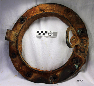
The iron-hulled, four-masted barque, the Falls of Halladale, was a bulk carrier of general cargo. She left New York in August 1908 on her way to Melbourne and Sydney. In her hold, along with 56,763 tiles of unusual beautiful green American slates (roofing tiles), 5,673 coils of barbed wire, 600 stoves, 500 sewing machines, 6500 gallons of oil, 14400 gallons of benzene, and many other manufactured items, were 117 cases of crockery and glassware. Three months later and close to her destination, a navigational error caused the Falls of Halladale to be wrecked on a reef off the Peterborough headland at 3 am on the morning of the 15th of November, 1908. The captain and 29 crew members all survived, but her valuable cargo was largely lost, despite two salvage attempts in 1908-09 and 1910. ABOUT THE ‘FALLS OF HALLADALE’ (1886 - 1908) Built: in1886 by Russell & Co., Greenock shipyards, River Clyde, Scotland, UK. The company was founded in 1870 (or 1873) as a partnership between Joseph Russell (1834-1917), Anderson Rodger and William Todd Lithgow. During the period 1882-92 Russell & Co., standardised designs, which sped up their building process so much that they were able to build 271 ships over that time. In 1886 they introduced a 3000 ton class of sailing vessel with auxiliary engines and brace halyard winches. In 1890 they broke the world output record. Owner: Falls Line, Wright, Breakenridge & Co, 111 Union Street, Glasgow, Scotland. Configuration: Four masted sailing ship; iron-hulled barque; iron masts, wire rigging, fore & aft lifting bridges. Size: Length 83.87m x Breadth 12.6m x Depth 7.23m, Gross tonnage 2085 ton Wrecked: the night of 14th November 1908, Curdies Inlet, Peterborough south west Victoria Crew: 29 The Falls of Halladale was a four-masted sailing ship built-in 1886 in Glasgow, Scotland, for the long-distance cargo trade and was mostly used for Pacific grain trade. She was owned by Wright, Breakenridge & Co of Glasgow and was one of several Falls Line ships, all of which were named after waterfalls in Scotland. The lines flag was of red, blue and white vertical stripes. The Falls of Halladale had a sturdy construction built to carry maximum cargo and able to maintain full sail in heavy gales, one of the last of the ‘windjammers’ that sailed the Trade Route. She and her sister ship, the Falls of Garry, were the first ships in the world to include fore and aft lifting bridges. Previous to this, heavily loaded vessels could have heavy seas break along the full length of the deck, causing serious injury or even death to those on deck. The new, raised catwalk-type decking allowed the crew to move above the deck stormy conditions. This idea is still used today on the most modern tankers and cargo vessels and has proved to be an important step forward in the safety of men at sea. On 4th August 1908, with new sails, 29 crew, and 2800 tons of cargo, the Falls of Halladale left New York, bound for Melbourne and Sydney via the Cape of Good Hope. The cargo on board was valued at £35,000 and included 56,763 tiles of American slate roofing tiles (roof slates), 5,673 coils of barbed wire, 600 stoves, 500 sewing machines, 6,500 gallons of oil, 14,400 gallons of benzene, plumbing iron, 117 cases of crockery and glassware and many other manufactured items. The Falls of Halladale had been at sail for 102 days when, at 3 am on the night of 14th November 1908, under full sail in calm seas with a six knots breeze behind and misleading fog along the coast, the great vessel rose upon an ocean swell and settled on top of a submerged reef near Peterborough on the south-west Victoria’s coast. The ship was jammed on the rocks and began filling with water. The crew launched the two lifeboats and all 29 crew landed safely on the beach over 4 miles away at the Bay of Islands. The postmistress at Peterborough, who kept a watch for vessels in distress, saw the stranding and sent out an alert to the local people. A rescue party went to the aid of the sailors and the Port Campbell rocket crew was dispatched, but the crew had all managed to reach shore safely by the time help arrived. The ship stayed in full sail on the rocky shelf for nearly two months, attracting hundreds of sightseers who watched her slowly disintegrate until the pounding seas and dynamiting by salvagers finally broke her back, and her remains disappeared back into deeper water. The valuable cargo was largely lost, despite two salvage attempts in 1908-09 and 1910. Further salvage operations were made from 1974-1986, during which time 22,000 slate tiles were recovered with the help of 14 oil drums to float them, plus personal artefacts, ship fittings, reams of paper and other items. The Court of Marine Inquiry in Melbourne ruled that the foundering of the ship was entirely due to Captain David Wood Thomson’s navigational error, not too technical failure of the Clyde-built ship. The shipwreck is a popular site for divers, about 300m offshore and in 3 – 15m of water. Some of the original cargo can be seen at the site, including pieces of roof slate and coils of barbed wire. The Falls of Halladale shipwreck is listed on the Victorian Heritage Register (No. S255). She was one of the last ships to sail the Trade Routes. She is one of the first vessels to have fore and aft lifting bridges. She is an example of the remains of an International Cargo Ship and also represents aspects of Victoria’s shipping industry. The wreck is protected as a Historic Shipwreck under the Commonwealth Historic Shipwrecks Act (1976).Porthole frame from the wreck of the Falls of Halladale. The encrusted frame has provision for eight bolts to hold it in place.flagstaff hill, warrnambool, shipwrecked coast, flagstaff hill maritime museum, maritime museum, shipwreck coast, flagstaff hill maritime village, great ocean road, falls of halladale, shipwreck peterborough, 1908 shipwreck, great clipper ships, russell & co., porthole frame -
 Flagstaff Hill Maritime Museum and Village
Functional object - Paper, circa 1908
This roll or reel of paper was part of a consignment carried as cargo of the Falls of Halladale. The iron-hulled, four-masted barque, the Falls of Halladale, was a bulk carrier of general cargo. She left New York in August 1908 on her way to Melbourne and Sydney. In her hold, along with 56,763 tiles of unusual beautiful green American slates (roofing tiles), 5,673 coils of barbed wire, 600 stoves, 500 sewing machines, 6500 gallons of oil, 14400 gallons of benzene, and many other manufactured items, were 117 cases of crockery and glassware. Three months later and close to her destination, a navigational error caused the Falls of Halladale to be wrecked on a reef off the Peterborough headland at 3 am on the morning of the 15th of November, 1908. The captain and 29 crew members all survived, but her valuable cargo was largely lost, despite two salvage attempts in 1908-09 and 1910. ABOUT THE ‘FALLS OF HALLADALE’ (1886 - 1908) Built: in1886 by Russell & Co., Greenock shipyards, River Clyde, Scotland, UK. The company was founded in 1870 (or 1873) as a partnership between Joseph Russell (1834-1917), Anderson Rodger and William Todd Lithgow. During the period 1882-92 Russell & Co., standardised designs, which sped up their building process so much that they were able to build 271 ships over that time. In 1886 they introduced a 3000 ton class of sailing vessel with auxiliary engines and brace halyard winches. In 1890 they broke the world output record. Owner: Falls Line, Wright, Breakenridge & Co, 111 Union Street, Glasgow, Scotland. Configuration: Four masted sailing ship; iron-hulled barque; iron masts, wire rigging, fore & aft lifting bridges. Size: Length 83.87m x Breadth 12.6m x Depth 7.23m, Gross tonnage 2085 ton Wrecked: the night of 14th November 1908, Curdies Inlet, Peterborough south west Victoria Crew: 29 The Falls of Halladale was a four-masted sailing ship built-in 1886 in Glasgow, Scotland, for the long-distance cargo trade and was mostly used for Pacific grain trade. She was owned by Wright, Breakenridge & Co of Glasgow and was one of several Falls Line ships, all of which were named after waterfalls in Scotland. The lines flag was of red, blue and white vertical stripes. The Falls of Halladale had a sturdy construction built to carry maximum cargo and able to maintain full sail in heavy gales, one of the last of the ‘windjammers’ that sailed the Trade Route. She and her sister ship, the Falls of Garry, were the first ships in the world to include fore and aft lifting bridges. Previous to this, heavily loaded vessels could have heavy seas break along the full length of the deck, causing serious injury or even death to those on deck. The new, raised catwalk-type decking allowed the crew to move above the deck stormy conditions. This idea is still used today on the most modern tankers and cargo vessels and has proved to be an important step forward in the safety of men at sea. On 4th August 1908, with new sails, 29 crew, and 2800 tons of cargo, the Falls of Halladale left New York, bound for Melbourne and Sydney via the Cape of Good Hope. The cargo on board was valued at £35,000 and included 56,763 tiles of American slate roofing tiles (roof slates), 5,673 coils of barbed wire, 600 stoves, 500 sewing machines, 6,500 gallons of oil, 14,400 gallons of benzene, plumbing iron, 117 cases of crockery and glassware and many other manufactured items. The Falls of Halladale had been at sail for 102 days when, at 3 am on the night of 14th November 1908, under full sail in calm seas with a six knots breeze behind and misleading fog along the coast, the great vessel rose upon an ocean swell and settled on top of a submerged reef near Peterborough on the south-west Victoria’s coast. The ship was jammed on the rocks and began filling with water. The crew launched the two lifeboats and all 29 crew landed safely on the beach over 4 miles away at the Bay of Islands. The postmistress at Peterborough, who kept a watch for vessels in distress, saw the stranding and sent out an alert to the local people. A rescue party went to the aid of the sailors and the Port Campbell rocket crew was dispatched, but the crew had all managed to reach shore safely by the time help arrived. The ship stayed in full sail on the rocky shelf for nearly two months, attracting hundreds of sightseers who watched her slowly disintegrate until the pounding seas and dynamiting by salvagers finally broke her back, and her remains disappeared back into deeper water. The valuable cargo was largely lost, despite two salvage attempts in 1908-09 and 1910. Further salvage operations were made from 1974-1986, during which time 22,000 slate tiles were recovered with the help of 14 oil drums to float them, plus personal artefacts, ship fittings, reams of paper and other items. The Court of Marine Inquiry in Melbourne ruled that the foundering of the ship was entirely due to Captain David Wood Thomson’s navigational error, not too technical failure of the Clyde-built ship. The shipwreck is a popular site for divers, about 300m offshore and in 3 – 15m of water. Some of the original cargo can be seen at the site, including pieces of roof slate and coils of barbed wire. The roll of paper is an example of cargo brought to Australia in the early 20th century. It is also significant for its association with the Falls of Halladale shipwreck, which is listed on the Victorian Heritage Register (No. S255). She was one of the last ships to sail the Trade Routes. She is one of the first vessels to have fore and aft lifting bridges. She is an example of the remains of an International Cargo Ship and also represents aspects of Victoria’s shipping industry. The wreck is protected as a Historic Shipwreck under the Commonwealth Historic Shipwrecks Act (1976).Roll of paper. Paper has remains of a wooden peg up through the centre and a lot of sedimentation. This roll was recovered from the wreck of the Falls of Halladale. It was part of a large consignment of paper listed as part of the cargo manifesto.flagstaff hill, warrnambool, shipwrecked coast, flagstaff hill maritime museum, maritime museum, shipwreck coast, flagstaff hill maritime village, great ocean road, falls of halladale, shipwreck peterborough, 1908 shipwreck, great clipper ships, russell & co., paper, reel, roll, paper reel, paper roll, cargo, consignment -
 Upper Yarra Museum
Negative Photographic Reproduction, Bridge over the Yarra
... bridge over yarra river... over yarra river 03050 Bridge over the Yarra. Upper Yarra Shire ...03050 Bridge over the Yarra. Upper Yarra Shire 1888-1988 Centenary collection. Black & white Negative, scanned at 600 dpibridge over yarra river -
 Warrnambool and District Historical Society Inc.
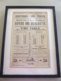
Poster - Armstrong and Fraser timetable, Late 19th Century
This poster is a time table for the coaches operated by Armstrong and Fraser.Their stables were in Liebig Street, Warrnambool next to the Commercial Hotel (The Whalers Hotel today) Armstrong and Fraser commenced business in 1882 and were prominent in Warrnambool at the end of the 19th century and the beginning of the 20th century. The kept as many as 70 horses in their stables and operated a daily timetable for tourists especially those going to the mouth of the Hopkins River and to the breakwater. This poster is of considerable interest as the time table indicates the extensive business of an early coach service in Warrnambool over 100 years ago. The poster comes possibly from the old Warrnambool Museum.This is a sheet of paper containing black printing and handwriting in black ink. It is encased in a black wooden frame with a white cardboard surround and a black border. It has glass protection. There is string and wire at the back for hanging the item . ARMSTRONG* AND * FRASER Special line of buses Running to HOPKINS AND BREAKWATER TIME TABLE (Also other detail re fares, Proudfoot's boating establishment and horses and conveyances) ( Handwriting 87,90, 91 January to March July to Sept. April to June Jany to March) warrnambool, bus timetable, armstrong and fraser -
 Warrnambool and District Historical Society Inc.
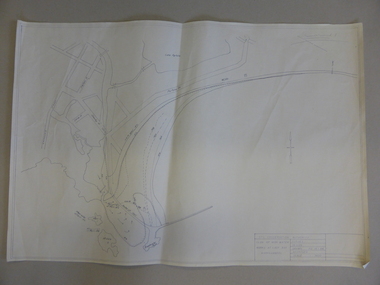
Map, Soil conservation authority:plan of high water marks at Lady Bay Warrnambool, 1984
This map documents the changing state of Lady Bay from around 1870 until 1976. It depicts the changing high water mark over that period and the main outlet of the Merri River in 1872 and 1976.This map provides a useful and significant insight into the ever changing face of Lady Bay from the 1870’s through to 1980’s. Cream paper map drawn with black ink showing Lady Bay and South Warrnambool section of Warrnambool. In lower RH corner Soil conservation AuthorityPlan of High water marks at Lady Bay Warrnambool. Drawn P.D. 19.1/84. Scale 1:3600. Written on back in black pencil: Lady Bay Historical HWM lady bay map, merri river 1872- 1976, merri river 1872- 1976, history of warrnambool -
 Warrnambool and District Historical Society Inc.
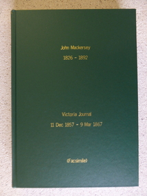
Book - Facsimile: John Mackersey 1826-1892, Victoria Journal 1857-1867, 2014
This diary relates to the property Kenilworth which is situated near Cavendish, 16 miles from Hamilton on the Wannon River. It was taken up by Thomas Norris in 1839 and originally carried 800 cattle and 20000 sheep on 63000 acres. By 1858 it was in the hands of John Mackersey and Thomas Bostock. In 1859 it belonged outright to John Mackersey who was there until 1870. He was considered a worthy son of a Presbyterian minister and was well regarded in the district for his contributions in church, sport and sheep breeding... However he did not do well and lost the property before going to New Zealand in 1870.This diary has detailed entries over a number of years which provides an insight into life in the 1860’s. It has a significance for Warrnambool as John Mackersey and Augustus Bostock were at one stage business partners.Hard green cover with gold lettering. 534 pages of facsimile copied diary entries. The entries date from 1857 to 1867. Acknowledgements to The State Government of Victoria, State Library of Victoria, Hamilton History Centre, Dr G Handbury AO, Margaret Gardiner, Godfrey and Margaret Mackersey, L Alan Brumley, M P Heuval.john mackersey, thomas norris, kenilworth, warrnambool history -
 Warrnambool and District Historical Society Inc.
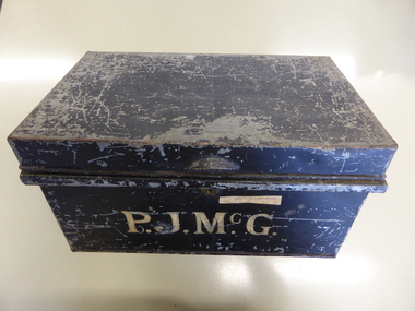
Box, Tin Box McGennan
Peter McGennan (1839-1920) arrived in Warrnambool in the 1870s and established a cooperage in Kepler Street and a boating business on the Hopkins River. He rebuilt the boating establishment after a fire in 1876. In 1896 McGennan established a Box and Case Factory in Davis Street (Merrivale Drive), importing timber from New Zealand, using chartered vessels and his own ships which included the ‘Speculant’. The box factory was a successful venture employing over 30 men until it was destroyed by fire in 1923. Peter McGennan was involved in the establishment of the Warrnambool Cheese and Butter Factory at Allansford and the Warrnambool Woollen Mill. He was a Director of the latter company until his death. Members of the McGennan family were also important business people in Warrnambool, being involved in the hotel business and civic affairs for many years. The tin box may have been used to house family papers or business documents during Peter McGennan’s life and it was used to house his estate papers after his death. Many of these documents are in the collection of the Warrnambool &District Historical Society.This box is of some importance as it belonged to a prominent Warrnambool businessman and his family. It has social significance as an example of the type of storage items used early in the 20th century to hold documents etc.This is a rectangular tin box with the black paint on the outside peeling and yellow paint inside. There is a metal lock which has no key. There is a small handle on the top added to the tin surface. The name ‘P.J.McGennan’ is painted on the front side in yellow paint.‘P.J.McGennan’ A typed label on faded yellow adhesive tape ‘Estate P.J.McGennan’ peter mcgennan, p j mcgennan, peter mcgennan metal box, mcgennan box factory, mcgennan warrnambool -
 Warrnambool and District Historical Society Inc.
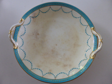
Plate, Rolfe dinner plates x 4, 1864
These dishes were part of a crockery set used in the George Rolfe household at Lyndoch, Warrnambool. George Rolfe (1836-1919) was a Melbourne tea merchant who acquired land at the mouth of the Hopkins River in Warrnambool from the 1880s on as a holiday home. He developed the property over the years, adding a windmill and reservoir, bone and chaff sheds, a stable, jetty and boathouse and an extensive garden. In 1891 he married Mrs Annie Lake and it was his stepdaughter, Florence Lake who built the house, Lyndoch in the 1920s. This building today forms part of an Aged Care Facility. This item is part of the larger Rolfe dinner set as described on Victorian Collections at VC001421 and VC001422These dishes are of importance as they belonged to the George Rolfe family of Lyndoch, Warrnambool. They demonstrate the quality of the household goods used by more affluent families in the second half of the 19th century. These are four china serving dishes or plates which are part of a set of crockery used in the Rolfe Lyndoch household in Warrnambool. The dishes have a circular base with a circular dish resting on the base. The dishes have or had two handles with these handles and the edges of the dishes being gold trimmed. Around the rim of the dishes is a pattern of loops and dots etc of teal and gold. One dish (.1) has no handles, one dish (.4) has one handle only and two dishes are cracked (.3 & .4) . Two dishes are stained, one severely (.2 & .4) ‘Minton’ george rolfe, florence lake -
 Warrnambool and District Historical Society Inc.
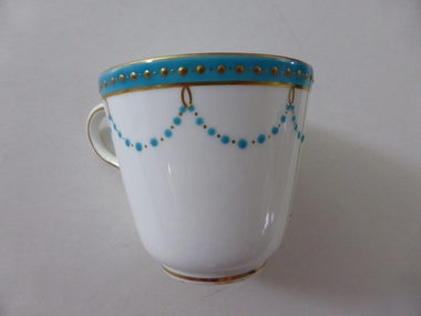
China, Cups x 4, 1864
These dishes were part of a crockery set used in the George Rolfe household at Lyndoch, Warrnambool. George Rolfe (1836-1919) was a Melbourne tea merchant who acquired land at the mouth of the Hopkins River in Warrnambool from the 1880s on as a holiday home. He developed the property over the years, adding a windmill and reservoir, bone and chaff sheds, a stable, jetty and boathouse and an extensive garden. In 1891 he married Mrs Annie Lake and it was his stepdaughter, Florence Lake who built the house, Lyndoch in the 1920s. This building today forms part of an Aged Care Facility. This item is part of the larger Rolfe dinner set as described on Victorian Collections at VC001421 and VC001422These cups are part of a crockery set, and are kept because they belonged to George Rolfe, a prominent property owner and farmer in Warrnambool in the late 19th century and early 20th century. The items, dating from 1864, have social significance showing the type of crockery used by a more affluent family in the 19th century.Four small white cups decorated with aqua band around the top of each cup . A scalloped pattern of dots are suspended from the solid band which is decorated with a row of gold dots. There is a gold rim at the base of the cup.Mintonrolfe, lyndoch, warrnambool, minton cups, mrs annie lake -
 Warrnambool and District Historical Society Inc.
Document, Wollaston sale, 1919
This is a poster advertising the sale of part of the Wollaston Estate in Warrnambool in 1919. The sections for sale were Allotments 1, 18 and 19 which included the Wollaston Homestead. The original Wollaston property of 679 acres was selected by Thomas Manifold in the late 1840s. This land, on the northern side of the Merri River, near the Woodford Road was three kilometres from the Warrnambool town. The first farmer we know who leased the property was William Simpson. Walter Manifold inherited the property and he took it over in 1884. The swing bridge he built in 1890 still stands today. In 1919 the Closer Settlement Board of Victoria acquired Wollaston and 17 lots were sold to returned soldiers for farming purposes. By 1930 there were only five soldier settlers remaining. In 2009 further subdivision took place with lots sold for residential purposes. The homestead allotments were sold separately in 1919 with various owners of the homestead itself recorded since that time. This poster is of interest as it shows the areas of the Wollaston Estate which were sold in 1919. The history of this estate is well-documented and of importance in the history of Warrnambool. This is a sheet of paper with red and black printing and a map of the Wollaston Estate which is photo-lithographed. The sheet has been folded three times. It has some small tears at the top of the page. wollaston, history of warrnambool, walter manifold -
 Kiewa Valley Historical Society
Photo Framed - Bogong Hotel, c 1930's
The Bogong Hotel, Tawonga, was 125 years old and destroyed by fire early December 2011. Mr and Mrs Crotty started the hotel - one daughter married a Higginson and they ran the pub for a number of years. The Hore family then took over - Dick and Essie, followed by Norman and Vera, then the other Hore brothers. The Bogong Hotel was 125 years old and the meeting place for people living along the Upper Kiewa River until it was burnt down in December 2011. Its publican was Vera Hore. Vera Margaret Elizabeth Hore was born 20th Nov. 1909 and died in July 2000. She was a keen amateur photographer. Black and white photo of a car in the front of the Bogong Hotel with two large trees. Framed with a 2 cm wide cream card board border and a black metal decorated frame surrounding it.On the back: "Vera Hore / Bogong Hotel"pub, upper kiewa valley, bogong hotel, vera hore, photographer -
 Kiewa Valley Historical Society
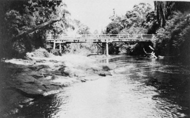
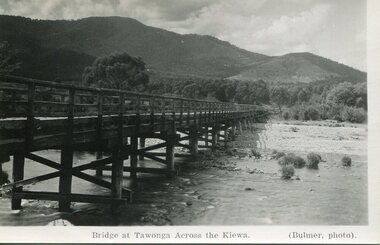
Photograph - Bridge at Tawonga 1936, 22/03/1936
... construction over Kiewa River at Tawonga Tawonga Bridge Kiewa Valley ...First Tawonga bridge was built in 1884- destroyed by floods in 1916. New bridge constructed 1923 and destroyed in 1953. Present concrete bridge constructed in 1986 and named Ryders BridgeBridge construction over Kiewa River at TawongaBlack and white photographic postcard of the bridge at Tawonga across the Kiewa River.Handwritten in pencil on rear of photograph - Sunday 22nd March, 1936. Printed on front - Bridge at Tawonga across the Kiewa (Blumer, photo)tawonga bridge, kiewa valley -
 Kiewa Valley Historical Society
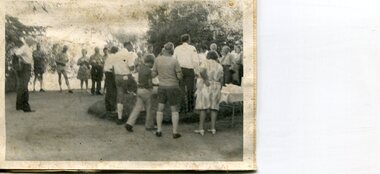
Photographs x 2 - Afternoon tea visit to Towong Hill
Towong Hill Homestead is a 110-year-old Federation style mansion situated on a rock outcrop, with views of about 260 degrees. It was built over 2 years by grazier Walter Mitchell from bricks made from local clay dug from the river bank, to be the family home for his new bride Winifred. They established their home in 1904. After the death of Walter in 1917, Winifred relocated her family, but the homestead remained in the families hands. In 1935, Thomas Mitchell (1906-1984) returned home to Australia, a successful Lawyer, and married city girl, Elyne Chauvel, and settled himself back at his childhood home, Towong Hill. Thomas was a world champion slalom skier, had been a prisoner of the Japanese at Changi, and was elected for the Country Party in 1946 and served as attorney-general in the McDonald government. His wife Elayne (1913-2002) is best remembered for her Silver Brumby series of novels for children. But Elyne also wrote a substantial number of non-fiction works about the Snowy Mountains. Photographs demonstrate local Kiewa Valley residents enjoying a community visit to the historic homestead at Towong Hill which holds significance to the early history of the area. Also demonstrates a pictorial history of social activities undertaken during this period2 black and white photographs mounted on buff card. Kiewa Valley residents attending afternoon tea at Towong HillHandwritten in black pen underneath photo - T.W.Mitchell Towong Hill. Afternoon Teat w mitchell, towong hill, kiewa valley -
 Kiewa Valley Historical Society
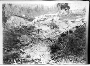
Black and white photograph, Early construction of Junction Dam Wall, c1940
In December of 1939 the excavation of a diversion tunnel was commenced to divert water from the East Kiewa River to allow construction of the dam wall. This was completed in February 1940. Lewis Construction Co. had the contract with excavation starting in February and the first batch of concrete placed in September. In 1942 the S.E.C. took over the construction and the wall was completed in March, 1944. Type of construction: reinforced concrete slab buttress.Of historical importance in the Kiewa area as it shows the form work and preparation necessary before the pouring of concrete for the first dam in the hydro electric scheme. The destruction caused by the 1939 bushfires is also evident in the upper left hand corner.A black and white photograph of the early construction of Junction Dam wall viewed from downstreamOn back of photograph (left hand upper corner) Junction Dam 4-4-81 Dam viewed from downstream 352 Time to use for correct Exp. 40 secjunction dam, bogong, secv -
 Kiewa Valley Historical Society
Photograph of Bogong Dam Wall Construction - 2 identical photos, c1940
Excavation of a diversion tunnel was commenced in 1939 to divert water from the East Kiewa River to allow construction of the dam wall. This was completed in February 1940 and excavation for the dam wall commenced in the same month, with the first batch of concrete placed in September. Lewis construction Company had the contract, but the S.E.C. took over construction in March 1942 and the dam was completed in March 1944. Type of construction: reinforced concrete, slab buttress.Importance in the Kiewa area as it shows the formwork and preparation necessary before the pouring of concrete for the first dam in the Kiewa Hydro Electric SchemeBlack and white photos (2 identical) of early construction of Junction Dam wall, viewed from downstream.Back of photo, upper right hand corner: No. 1 - Construction of Bogong Dam Wall (written in pencil) No. 2 - Same as one (written in pencil)construction, dam wall, excavation, bogong, secv -
 Kiewa Valley Historical Society
Black and white photo of Junction Dam wall under construction, c1940
In December of 1939 the excavation of a diversion tunnel was commenced to divert water from the East Kiewa River to allow construction of the dam wall. This was completed in February, 1940. Lewis Construction Company had the contract with excavation starting in February and the first batch of concrete placed in September. In 1942 the SECV took over the construction and the wall was completed in March, 1944. Type of construction: Reinforced concrete, slab buttress.Of historical importance in the Kiewa area as it shows the form work and preparation necessary before the pouring of concrete for the first dam in the hydro electric scheme. The destruction caused by the 1939 bushfires is also evident in the upper left hand cornerBlack and white photo, early construction of Junction Dam Wall, viewed from downstreamOn back of photo (left hand upper corner) Junction Dam 5-4-81 Dam viewed from downstream. 352 Time to use for correct exp. 40 sec.bogong, junction dam, secv -
 Kiewa Valley Historical Society
Photographs- 1 old black and white photograph of a wooden bridge over a river possibly Ryders Bridge in Tawonga. 2 –Enlargement of the original photograph showing the gentleman leaning on the bridge. Taken off the original photo
... bridge over a river possibly Ryders Bridge in Tawonga. 2... bridge over a river possibly Ryders Bridge in Tawonga. 2 ...The bridge is not definitively identified, but is of similar construction style to other bridges built in rural areas around this time. Circa 1930”s and may be Ryders Bridge (Old Tawonga Bridge) which crosses the Kiewa River on Mountain Creek Rd Tawonga The first Tawonga bridge was built in 1884- destroyed by floods in 1916. New bridge constructed 1923 and destroyed in 1953. Present concrete bridge constructed in 1986 and named Ryders Bridge These wooden bridges were the only method for transporting stock and produce to market, transporting timber to the mills, sending and receiving mail and for local people to cross the many rivers in the area to go about their daily business. 1- Black and white photograph is glued onto heavy cardboard, which is yellowing with age. Top right hand corner has a tear in the cardboard. Photograph depicts a wooden bridge on wooden piles with 2 white wooden railings along the length of both sides. 2- Original photo has been digitally enlarged to show a gentleman in a light coloured suite and wearing riding boots leaning on the rails of the bridge. The bridge is not definitively identified, but is of similar construction style to other bridges built in rural areas around this time. Circa 1930”s may be Ryders Bridge (Old Tawonga Bridge) which crosses the Kiewa River on Mountain Creek Rd Tawonga bridge; tawonga bridge; kiewa valley -
 Kiewa Valley Historical Society
Book - Kiewa River, Stocking and Crossing the Kiewa River by Jan Hunter (nee Chick), 2020
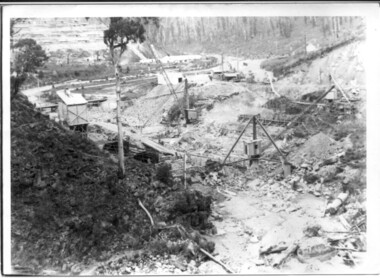
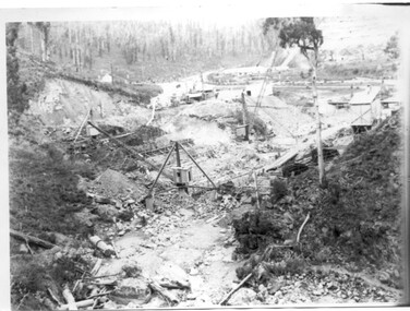
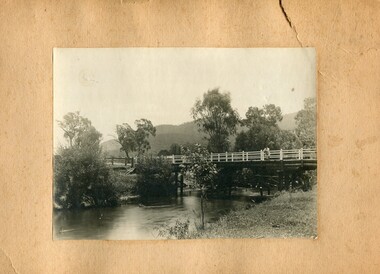
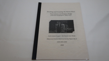
The Chick brothers, Alf, Les and Allan, plus friends, began trout fishing and camping in the Kiewa Valley before the early 1930s. Les continued his connection with the Kiewa River until his death in 1972. Fingerlings were placed in the Kiewa River from the early 1880s. Keegan's Bridge is a crossing near Upper Gundowring and about 4 km south east of Dederang. References to the crossing were made in the early 1900s and a petition presented to Council in 1904 calling for a bridge.The bridge was built and opened in 1907. The photos are of the release of fingerling trout in the Kiewa River, thought to be at Keegan's Bridge. The fingerlings were transported in drums on the back of trucks. The photos are c1940s.The Kiewa Valley has been a popular spot for fishermen, tourists and campers from the 1880s. One of the many attractions has been the excellent fishing along the Kiewa River due to the regular release of fish especially brown trout. This continues to the present day (2020) when a few fish were marked with $$ signs for the lucky fisherman who caught them. This attracts visitors, their families and boosts the economy and dates back to visits at the Tawonga Pub prior to the Kiewa Hydro Electric Scheme.19 page book with black plastic spine and clear plastic cover over the beige paper cover with title , author and black & white photo. Note: In KVHS photo collection there are 4 good quality reproduction photos on photographic paper. These have been produced professionally. These photos of Jan Hunter's are featured on the second page of her book. These also have a letter attached. The book is a pre-research paper & is No 33 of the Albury and District Historical Society Papers. The sub-title is "Trout releases and Keegan's Bridge / from the newpapers, 1882-1935"None on the book but a letter is attached from Jan Hunter, the author as a follow up to the photos she donated. On the photos - On the back: Fujifilm / Fujicolor Crystal Archive / Paper / Production - run codekiewa river; trout; fish; keegan's crossing; keegan's bridge; fingerlings; chick family; camping; tourism -
 Kiewa Valley Historical Society
Photograph - 30 black and white photographs (assorted sizes) plus page from a newspaper and copied article on A4 paper, c1880's c1910 - 1920 (photographs) Newspaper 1961
K2,3 and4 are of the Kiewa River and two of the bridges spanning the river along the valley. K3 and K4 would have been taken in the 1880's and show the type of trees and plant growth along the river prior to land clearing for farming. K5 is of the Running Creek Cricket Team and therefore there was sufficient population in the area to form and maintain a team as well as have other teams in the relatively near vicinity to provide competition. Note the horse drawn cart which provided transport. Date taken is unknown but possibly c 1910. The Mt. Buffalo Chalet was built in 1910 by the Victorian Government. It was Australia's first ski resort and has served generations of skiiers, hikers and families over the years. It was built for 3195 pounds and has had stories and wings added since and is the largest timber building in Australia. B4 is the earliest photo in this group as the garden is in early stages of development - the other photos show the growth of the shrubs and would be taken about c 1920. Note the cars and motor bikes. It closed in 2006. The other photos are of general interest only but interesting to see that there were donkey's grazing. There is no information as to their purpose on Mt. Buffalo. Four different Kiewa Valley families are represented in the photographs. Their descendants still live in the Valley and carry on the traditions of beef and dairy farming. Of particular interest is the photo of Miss Marjorie Clemence, the first School Teacher of Upper Gundowring School. Gundowring pastoral run was taken up in 1838 and occupied by framers in the 1860's. The area was known as Gundowring and Upper Gundowring. The Gundowring School was opened in 1871 and most likely the Upper Gundowring school would be built at the same time. It was School No. 2733 and situated in Boyd Road. It closed in 1953 when the Kiewa Consolidated School opened. The newspaper page describes the activities in which the local community of Kergunyah were in engaged in that period - Red Cross, Fire Brigade, cattle round up and some of the identities involved. The article photocopied from the Yackandandah times states that he (Norman Coad) "was sent to the Ovens District Hospital, Beechworth for treatment" which would mean that this was the closest hospital to the Kiewa Valley for emergencies in 1912.The Kiewa Valley photographs are of social significance showing two of the early bridges allowing the community easy access to both sides of the river and also the tree and plant growth before land clearing for farming. The photos of Mt. Buffalo Chalet have social, architectural and historical significance. the Chalet has been used by skiers, bush walkers and day trippers since its completion in 1910 and its closure in 2006. It is listed in the Victorian Heritage Register. The family photographs are of social and historical significance as they are of early farming families in the Kiewa Valley and also depict the dress, of both men and women) in the late 1880's. The write up in the Weekly Times has social significance as it depicts the social and farming activities and photos of the local residents from around that area. The article from the Yackandandah Times is of a personal nature with concern for the individual involved. Note: There is a photo of the gentleman mentioned in the article (Mr. Norman Coad) in the Families of the Kiewa Valley (F4) as above.30 black and white photographs - 5 of the Kiewa Valley, 8 of families of the Kiewa Vallley and 17 of Mt. Buffalo. Various sized photos. Page from the Weekly times and copied article from the Yackandandah Times on A4 sheet.(Note for easier identification they have been numbered and grouped - K1-5 (Kiewa Valley), F1-8 (Families) and B1-17 (Mt. Buffalo). K1: handwritten in ink, lower L hand corner "Bogong in the distance". K2: handwritten in ink lower L hand corner "Mongan's Bridge or Towonga". K3 handwritten in ink "Taken from Mongan Bridge looking up stream". K4 - no inscription. K5: handwritten in ink, back of photo "Running Creek Cricket Team". F1: handwritten in ink on back "Mrs. Heap" and lower down in pencil "1880's". F2 handwritten in pencil at top of back phot "Land at Tawonga TROVE The Y'dah Times 20/2/1913" and lower down in ink "Henry Ellis Larkin". F3: handwritten in ink bottom edge "Mrs Coad". Note that this photo is a postcard. F4: Written in ink lower edge "Norman Coad". Note this photo is also a postcard. F5: Lower left corner in Ink "Harry Larkin". F6: lower half back of photo, in ink "Bernie Maddison". F7: on back of photograph in ink "Miss Marjorie Clemence first School Teacher Upper Gundowring: and underneath, in pencil "C1880's". F8: Handwritten in ink on back of photo "Frank & Mrs. Keat & Lesley of Tawonga". Lower down in pencil "c1912-1914". B1: Back of photo in ink "The Chalet Mt. Buffalo". B2: no inscription. B3: "chalet at Bufflo" in ink lower left corner. B4: This is a post card. Written in ink is "Mt. Buffalo Chalet". B5 - B10 printed in ink, lower left corner "Buffalo". B11: no inscription. B12: "Mt. Buffalo" lower R corner. B13: "Buffalo?". B15: Printed in ink lower edge "Picnic at Buffalo". B16: "Donkeys on Mt. Buffalo" printed in ink lower edge. B17: handwritten in ink across back of photo "Donkeys & top of Mt. Buffalo with the Monileith in the distance". A4 sheet of paper describing an accident to Mr. Norman Coad. Under article is : Yackandandah Times (Vic: 1890 - 1931), Thursday 18 July 1912, page 3. A page torn from the Weekly Times, June 14, 1961 and entitled "Kergunyah has picturesque setting". kiewa valley, farming, families, kergunyah, gundowring upper, mt. buffalo chalet, briggs family, larki family, coad family, clemence family, laskowski collection -
 Kiewa Valley Historical Society
Mt Beauty High School Blazer
Mt Beauty High School commenced in 1953 as a Higher Elementary school as the need for a secondary college grew with the increase in population due to the Kiewa Hydro Electric Scheme. It became the Mt Beauty High School in 1964. The blazer was part of the winter uniform.Historical: Education in Mt Beauty commenced relatively late so there was less of a tradition The decision to adopt a uniform is of interest to compare with other schools and the times.Dark green blazer made from pure wool flannel. Size 38. with 3 green buttons down the front left side where the edge meets the right side (no overlap). ! pocket bottom right and bottom left sides. 1 on top left side. Top left pocket has coloured school emblem embossed on as part of the pocket. Long sleeves lined with white cotton. On inside of top pocket is make of blazer with 'J. Nelson' sewn on. inside middle back of collar a small label of maker.Outside left pocket: 'High School' above picture of mountains and river and below 'Mount Beauty.' Inside left pocket. Pinehurst / Blazer/ 'J. Nelson' sewn over (what might be Made by / Stamina / The "Doctor" pure Wool Flannel & tag 38. On middle inside at collar: Stamina / Productionuniform. school uniform. mt beauty. education. clothing. wool. mt beauty high school., blazer -
 Kiewa Valley Historical Society
Photo - Cleve Cole
This photo depicts the rescue of three local skiets that became trapped on Mt Bogong during a blizzard and became known as the Cleve Cole tragedy . Mick Hull Howard Michell and Cleve Cole where skiing on Mt Bogong and could not find their way off the mountain via Staircase Spur due to Blizzard conditions and ended up in the Mitta Valley. Howard Michell walked to the Battys farm to get help for his weak and injured friends. Cleve Cole died shortly after arriving at Omeo hospital. This photo is historically significant as it tells the rescue story of this tragedy. The photos are of the people involved which add to the story. Mt Bogong Victoria's highest mountain is accessed from the Kiewa Valley and near by high plains and over shadows Mt Beauty township therefore is a local story. The photo comes from the rescue party which is a rare photo and thus has great interpretive capacity . The skiing history is one of KVHS main themes and this photo is part of our Skiing Across Country exhibitionBlack and white photo of several men in the bush near Mt Bogong. Photo is glued on to cardboard with a dark grey border and light grey wider border on the outside.Handwritten on back "The Discovery of Cleve Cole / up the Big River (Below Paddy's Flat) / Cole is arrowed / Cyril Rootsey / Jack Batty / Bill Batty / Paul? Bitner / Tom Fitzgerald / Etc. / (I think dad is the one with his hand up to his face)" Back - red stamp - "Herald Feature / Service / Melbournecleve cole. mt bogong. big river. paddy's flat. -
 Christ Church Anglican Parish of Warrnambool
Plate, Untitled, Brass Alms dish, C.1902
Brass Collection Plate presented to St Paul's Anglican Church, Allansford, by the mother of Joseph & Frank Dallimore as a Memorial to the two brothers who drowned at Ryan's Den (near Cape Otway) on Jan 1st 1903. Major Joseph Dallimore (aged 32) was on leave from Sth Africa during the war and he, his wife (Beatrice Wiggs) and baby, his brother Frank Rupert Dallimore (aged 22), a farm hand Arthur Geach (aged 19) and a house maid servant, were picnicing at Ryan's Den (near Cape Otway) when the three men went walking, but never returned, all assumed drowned. One theary has it - Mrs M.E. Dallimore was picnicing at Lake Gillear beach when an enormous wave swept over the shore - (much larger than any other during that day) and rolled in all along the beach. This wave may have also reached the area where the three men were walking on the rocks and swept them into the ocean. Only one body was recovered - some 4 weeks later - that of Frank Rupert Dallimore and washed into Brown's Creek, 1 mile from the Johanna River and ten miles east of Ryans Den.It is a memorial plate and records the family's attachment and importance to the Church.Brass engraved and embossed Memorial Collection PlateEmbossed wording around edge of plate in Old English font reads - "All things come of Thee and of Thine own have we given Thee". The inscription on the tondo of the plate reads - "TO THE GLORY OF GOD / AND IN MEMORY OF / JOSEPH & FRANK RUPERT DALLIMORE, / WHO WERE DROWNED AT RYAN'S DEN, / JAN 1ST 1903. / PRESENTED BY THEIR LOVING MOTHER, / M.E.DALLIMORE."brass st pauls anglican church allansford warrnambool church of england christ church parish of warrnambool collection plate memorial plate dallimore drowning ryan s den alms dish -
 Warrnambool and District Historical Society Inc.
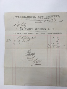
Document, Warrnambool New Brewery, 1870s
This is an invoice sent from the Warrnambool New Brewery (Walter Sheldrick & Co.) to Captain Selby. The Bill was for two dozen ales ordered on November 4th 1873 and for 6 dozen ales ordered on November 24th 1873 (cost £6-18-0). The bill was paid in February 1874. The Warrnambool New Brewery was established in 1868 by a company headed by a Warrnambool butcher and hotel proprietor, Walter Sheldrick. It was at the corner of Timor and Fairy Streets. After the first year the company was wound up and Walter Sheldrick and Thomas Price and, initially, two other partners, continued on the business. Sheldrick died in 1876 and his son Richard took over the business. By 1892 he had left the business and the brewery was operated by Edward Price, Edmund Hutton and William Trigg. In 1894 the brewery was sold and continued on until it was closed in 1922. The labels of Warrnambool Sheldricks ales had been known throughout the Western District for over 50 years. Captain Selby came to Warrnambool in the late 1860s and lived at ‘Clifton’ on the banks of the Hopkins River not far from the mouth if the river. He was a keen sportsman and was prominent in the Anglers Society, the Rowing Club (as President) and the Gun Club (pigeon shooting).As this is an original 1873 docket it is of considerable interest. It refers to the Warrnambool New Brewery, a prominent business in Warrnambool for over 50 years and to Captain Selby, well-known at the time in sporting circles. We have a good collection of other Captain Selby dockets. This is a buff-coloured piece of paper, an 1873 invoice sent from the Warrnambool New Brewery (Walter Sheldrick and Company) to Captain Selby of Warrnambool. The docket has printed red lines and both printed and handwritten material in black ink. The page has one small tear.warrnambool, walter sheldrick, captain selby, warrnambool new brewery, sheldrick ales