Showing 13832 items matching "tasmanian-built"
-
 Melbourne Royal
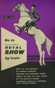
Poster, Go to Melbourne's Royal Show by train, 1958
This poster promotes the merits of travelling by train to the Royal Melbourne Show of 1958. The Showgrounds train station was one of the first buildings built on the Melbourne Showgrounds in Ascot Vale when the site was established in 1883, allowing patrons quick access to the venue despite it being slightly further out from the city than previous sites.A poster, printed portrait and in colour. The upper half of the poster shows a woman on a jumping horse, on a purple background; the lower half consists of a list of the advantages of taking the train, lettered in white on a black background; screenprint and process lithograph, linen-backed.SEPT. 19 – 28 / Go to / MELBOURNE'S / ROYAL SHOW / by train / - RIGHT TO THE GROUNDS / - NO PARKING PROBLEMS / - COMBINED RAIL-ADMISSION TICKETS / - WEEKLY OR NINE DAY RAIL TICKETS / - SEE THE RAILWAYS EXHIBIT / - MEMBERSHIP TICKETS AT VICTORIAN / GOVT. TOURIST BUREAU /train, metro trains, showgrounds, melbourne showgrounds, royal melbourne show, 1958 melbourne royal show, melbourne royal show, showgrounds station, railway -
 Melbourne Royal
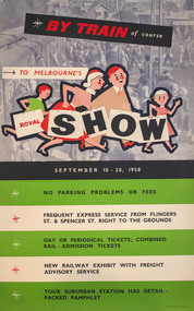
Poster, W. M. Houston, By train of course, to Melbourne's Royal Show, 1958
A poster promoting the merits of travelling by train to the Royal Melbourne Show of 1958. The Showgrounds train station was one of the first buildings built on the Melbourne Showgrounds in Ascot Vale when the site was established in 1883, allowing patrons quick access to the venue despite it being slightly further out from the city than previous sites.A portrait poster, printed in colour; in the upper half of the poster there is an illustration showing a family of four, walking to the right; in the background is a photograph of a train station; the lower half of the poster consists of a list of the advantages of taking the train, printed on five horizontal stripes, white and green; colour process lithograph, linen-backed.BY TRAIN of course / TO MELBOURNE'S / ROYAL SHOW / SEPTEMBER 18 - 28, 1958/ NO PARKIGN PROBLEMS OR FEES / FREQUENT EXPRES SERVICE FROM FLINDERS ST. & SPENCER ST. RIGHT TO THE GROUNDS / DAY OR PERIODICAL TICKETS; COMBINED RAIL-ADMISSION TICKETS / NEW RAILWAY EXHBIIT WITH FREIGHT ADVISORY SERVICE / YOUR SUBURBAN STATION AHS DETAIL-PACKED PAHMPHLET /train, metro trains, showgrounds, melbourne showgrounds, royal melbourne show, 1985 melbourne royal show, melbourne royal show, showgrounds station, railway -
 Linton and District Historical Society Inc
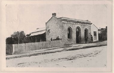
Photograph, Bank of New South Wales, circa 1872
Original photograph thought to have been taken about 1872 (before the building was renovated and enlarged), however copy in "Bank of New South Wales" file gives date 1862, most likely the year the bank was built. This building was later known as "Traquair House". It was lived in by the Lewers family, and later by Mrs. Stella Surman.Black and white copy of an early photo of the Bank of New South Wales in Linton. Three men are standing in the street outside the building. Two copies of photo: 1. Has been mounted on card. Back of card is stamped "Easter 1983, Historical Exhibition, Linton Park"; 2. copy which appears to have been printed from a scan.bank of new south wales linton, traquair house -
 Sunbury Family History and Heritage Society Inc.
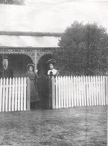
Photograph, The Fanning family, c1890
The Fanning Family home, 'Sunnyside', was built in Loemans Road after William Patrick Fanning migrated from Thurles, Co Tipperary, Ireland. He was one of the early farmers in Bulla. He and his wife, Catherine had five children. Since he and his wife died their descendants continued to live at 'Sunnyside' in Bulla. The Fanning family were one of the early settlers in Bulla during European settlement.A photocopied black and white non-digital photograph of a man, lady and young girl standing behind a picket fence outside a weatherboard Victorian cottage with a galvanised iron roof. The family are smartly dressed in clothes fashionable in the 1890s.A label with 'The Fanning Family' printed on it has been stuck on the side of the photograph.'sunnyside', bulla bulla, fanning family, loemans road -
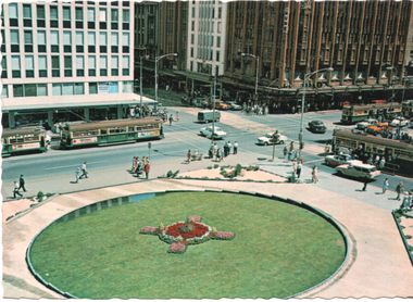 Melbourne Tram Museum
Postcard - Civic Plaza or City Square - Swanston & Collins Sts, Nucolorvue Publishing, c1968
The photograph shows the Melbourne City Square, though titled "Civic Square" taken from the Regent Theatre looking northwest. Shows an early version of the square and four trams. The square has undergone many changes since it was first built in 1968 - see reference. Postcard published by Nu-color-vue - card No. ML97Yields information about an early layout of the Melbourne City SquarePostcard - serrated edges, full colour, divided back.melbourne, postcard, nu-color-vue, swanston st, collins st, city square, civic square, trams, tramways, mmtb, w3 class, sw6 class -
 Buninyong & District Historical Society
Photograph - Colour photograph, Buninyong Uniting Church, 1990s
Former Presbyterian church built in 1860, with foundation stone laid by Mrs Scott, snr, the oldest resident in the district on Tuesday 27th March 1860. In 1970 the congregations of the Presbyterian and Methodist Churches combined to form the Buninyong United Church. When the Uniting Church in Australia was formed in 1977, the church became the Buninyong Uniting Church.A very early church of the districtColour photograph of Buninyong Uniting Church, with two large trees near the adjacent church hall"Uniting Church Buninyong, 1990s"buninyong, uniting church, presbyterian church -
 Ballarat Heritage Services
Photograph - Hotel, Clare Gervasoni, Commercial Hotel, Sheep Hills, 2017, 08/10/2017
Sheep Hills is located Sheep Hills in the northern Wimmera region, north-west Victoria between Warracknabeal and Minyip. The hotel was built in 1884 and was originally known as Jenkins Hotel. In 1903 it was called the Railway Hotel. The name Commercial Hotel was used from 1915, and Mr Cain bought the hotel in 1950. in 2017 it was a private residence.A brick hotel at Sheep Hills, Victoriasheep hills, commercial hotel, wimmera -
 Box Hill Historical Society
Photograph - Barwon Street Family Centre, Simon Fox, 1/12/1994
Barwon Street Family Centre, located at 15 Barwon Street, Box Hill North, provides services such as Maternal and child health, family day care, family counselling, visiting specialists and playgroups. It is a modern brick building, built in 1993 and the first of two planned for the City. (See p.27 "The Days We Remember")B&w photoday care, maternal and child health centres, welfare services, barwon street, box hill north, the days we remember -
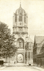 Federation University Historical Collection
Postcard - black and white, Tom Tower, Christ Church, Oxford, c1916
Tom Tower is a bell tower in Oxford, England, named for its bell, Great Tom. It is over Tom Gate, on St Aldates, the main entrance of Christ Church, Oxford, which leads into Tom Quad. This square tower with an octagonal lantern and facetted ogee dome was designed by Christopher Wren and built 1681–82. (Wikipedia)Black and white postcard showing the Tom Bell Tower at Christ Church, Oxford. chatham-holmes family collection, oxford, bell, great tom, church, christ church -
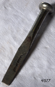 Flagstaff Hill Maritime Museum and Village
Tool - Caulking Tool, Ward & Payne Ltd, Late 19th century
Caulking is the traditional technique used on wooden vessels built with butted or clinker-built planks to fill the gaps between these planks while still allowing the wood to flex and move. This involved driving the irons, hammered in with the mallet, deep into the seams to open them up. After this, spun yarn, oakum (hemp) or cotton was driven deep into the gaps. The hemp or cotton was soaked in creosote or pine tar to make the joins watertight. Caulking also played a structural role in tightening up the hull or deck by reducing the longitudinal movement of the neighbouring planks. The subject item was made by Ward & Payne of the Limbrick Works at Hillsborough, Sheffield England manufacturers of hand-forged tools. Their trademark registered in 1850 was a Letter "W" & "P" stamped into the steel. The firm was established by David Ward (1767-1822) in 1803 the company became David Ward & Sons, in 1837 after Ward's son Edward joined the firm. In 1845 Henry Payne the founder's son-in-law became a partner but died in 1850 after which the company reverted to the Ward family. The business then concentrated on making carving tools, chisels and gouges. In 1882 David Ward's grandson David Ward Jr. (1835-1889) purchased land and built a factory at Sheffield North known as the "Limerick Wheel". For a time Wards operated from both 106-114 West Street Sheffield and at Limbrick Road, Hillsborough on the river Loxley. By 1911 they had expanded into making spades, forks, sheep shears and many other types of edged tools including drills and wood planes. In 1967 Wilkinson Sword purchased all the company's share capital and continued to sell Ward & Payne tools until 1970 when a fire burned the factory down and housing development was built on the site. The subject item is significant as it gives a snapshot of the technological development of sailing ships and their operation before steam-powered vessels took over around the world. Tools such as the subject item demonstrate the traditional craftsmanship and skill of the shipwright and the aesthetic quality of the timber ships designs of the time. Caulking tool with square end"WARD Sheffield"flagstaff hill, warrnambool, flagstaff hill maritime museum, shipwreck coast, flagstaff hill maritime village, james s steele, caulking iron, caulking tool, shipwright tools, ward & payne sheffield, forged tools -
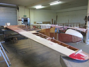 Australian Gliding Museum
Machine - Glider - Sailplane, 2012
The ES52 Kookaburra is a two seat high wing glider – sailplane of wooden construction designed by Harry Schneider and built Edmund Schneider Pty Ltd. It was first flown on 26 June 1954 and became the glider of choice for training new pilots of many gliding clubs around Australia in the 1950s, 1960s and 1970s. Several found there way to New Zealand. Further two kits were sent to Brazil and at least one of these was finished and flow successfully. The ES52 performed well with a glide ratio of about 22:1 and had soaring and cross-country capabilities. A notable feature of the ES52 design was the staggered side-by-side seating arrangement of the cockpit. This made for good in flight communication between instructor and trainee. Overall, thirty six were built by Edmund Schneider Pty Ltd. A longer wing version (the ES52B) was also introduced that had a better glide ratio (around 25:1). Five examples of this version were built. In Germany a modified ES52 was built incorporating a metal tube fuselage frame and with the addition of a engine driven propeller mounted on top of the wing which enabled the glider to be self launching. This museum collection item consists of the fuselage, tailplane, elevators, fin, rudder from the Mark I, ES 52 Kookaburra, formerly registered as VH-GFF and last owned by the Barcaldine and District Airsports Club of Queensland. The glider was in a damaged condition when it was acquired by the Museum. A decision was made by the Museum to repair the glider for display rather than endeavouring to restore it to an airworthy condition. The reconstruction of the wings is being undertaken by using parts of damaged ES 52 Kookaburra wings (as it happened from later ES 52 Marks). The Log Book for VH-GFF reveals operational life with a succession of gliding clubs around Australia. This exhibit will be of interest to gliding enthusiasts wishing to inspect the popular two seat club trainer of a by-gone era.This is a wood and fabric covered aircraft that is being rebuilt from the components of several aircraft as a non-flying exhibit.Fuselage marked with Edmund Schneider Pty Ltd Serial Number 9 and comes from the glider previously registered as VH-GFF.australian gliding, glider, sailplane, edmund schneider, es 52, kookaburra, barcaldine and district airsports club, victorian motorless flight group, alice springs gliding club, raaf richmond, raaf williamtown, gayndah gliding club, blackwater gliding club, southern downs aero and soaring club, charleville gliding club -
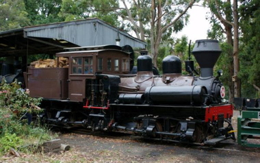 Puffing Billy Railway
Number 14 - Shay Locomotive (Builder’s Number 2549), 22 June 1912
geared steam locomotive Built by the Lima Locomotive Works, USA in 1912 (Builder’s Number 2549). “Class a” 13 Ton (13.3 tonne) . This locomotive hauled freight on the Ali-Shan Forest Railway in Taiwan and is capable of pulling 90 Tons (91.8 tone) loads over steep gradients at low speeds. . This A-type Shay locomotive was built by Lima Locomotive Works, Ohio (builder's number 2549 of 1912) for the Alishan Forest Railway, Taiwan. The Alishan Forest Railway featured a large fleet of Shay locomotives and many still survive, together with a portion of the railway which is now a tourist operation. Alishan Shay No.14 was gifted to the Puffing Billy railway in 1971 by the Alishan Forest Railway - Taiwan Government forest Bureau and arrived on the 12th October 1971 at the Puffing Billy Museum at Menzies Creek. Loco: Shay No.14 ( Shop Number 2549 ) Class: A 18-2 ( 2-cylinders / 2-trucks Class A ) Built for: Alishan Forest Railway Bulit by Lima Locomotive Corporation In service 22 June 1912 Samuels, Samuels & Co., Ltd. (D), Taipei, Formosa (Japan); For: Alishan Forest RY #14, Kirun (Keelung), Formosa, (Japan) (1945) Alishan Forest RY #14, Keelung (Chilung), Taiwan (12 Oct 1971) Puffing Billy RY #14, Belgrave, Victoria, Australia Gauge 30" Status Preserved - In Storage at Museum There is only one original LIMA mark left on any of the Alishan RY Shays and it has no number. All of their Shays have been re-built, changing much of the original Lima product. Most were renumbered for various reasons without regard to Lima Shop Numbers over the years. "Girder Type Frame" details from http://www.shaylocomotives.com/data/lima3354/sn-2549.htm Historic - Industrial Narrow Gauge Railway - Geared Steam Locomotive which worked on the Alishan Forest Railway, Taiwan.geared steam locomotive - Class: A 18-2 ( 2-cylinders / 2-trucks Class A ) - made of wood and iron and wrought iron, Glass14puffing billy, shay, geared locomotive, steam locomotive, industrial narrow gauge railway, 2'6", ali shan forest railway -
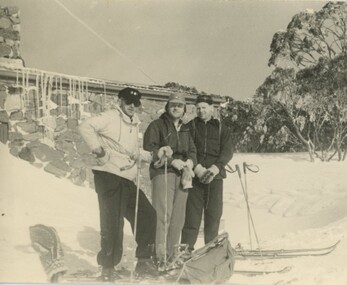 Falls Creek Historical Society
Photograph - Bogong Trip 1951- At Cleve Cole Lodge
MEYER COLLECTION - FALLS CREEK PHOTOS In 1947 a determined group of like-minded State Electricity Commission (SEC) staff including Ray Meyer, the chief surveyor of the Kiewa Hydro-Electric Scheme, had a common interest that revolved around the skiing potential of the snow-covered high plains which included what is now the resort of Falls Creek. The six SEC employees, Toni St Elmo, Ray Meyer, Jack Minogue, Lloyd Dunn, Adrian Ruffenacht and Dave Gibson (together with their families) banded together to secretly build a 'hut' that was the first ski lodge at Falls Creek. Using a road built in 1930s to gain access to Falls Creek, their hut project was carried out in secret as efforts by other skiers were blocked by H.H.C. Williams – the engineer in charge of the Hydro Scheme. In 1946 Ray Meyer made a trip to the Lands Office in Melbourne. He came away with a 99-year lease on three acres that was ideally suited for a hut designed by Lloyd Dunn. Adrian Ruffenacht (Design Engineer for the KHS) had suggested where the group should build because of easy access to a spring for water. Much of the building material required was scavenged from derelict huts on the high plains. Due to the need for secrecy, the determined group worked on the hut in the evenings and weekends to avoid detection. During the building period the group had met at Echidna Rock (now known as Eagle Rock) where Skippy St Elmo announced, "This is my favourite ‘Skyline’.” And so the first lodge in the area at Falls Creek Ski Resort came into existence. With the development of the International Poma in the 1970s, the Skyline Lodge, which was sited between the ski-lift’s pole one and pole two, was demolished. However, the legacy of Ray Meyer, Toni St Elmo, Jack Minogue, Lloyd Dunn, Adrian Ruffenacht and Dave Gibson and Skyline lives on in the vibrant atmosphere of Falls Creek Resort. The MEYER COLLECTION documents developments on the Kiewa Hydro Scheme and their life at Falls Creek from the mid 1930s to 1960s.This image is significant because it depicts aspects of the life of a pioneering family of Falls Creek and the founders of "Skyline", the first lodge at Falls Creek.Black and White Images of visitors at Cleve Cole Lodge. Photo 1. L to R:- Ray Meyer, H. Gibbs and Wal Johnson. Photo 2. Ray Meyer and Wal Johnson having photo taken. CLEVE COLE HUT was built in 1937 for the Ski Club of Victoria, to commemorate pioneer skier, Cleve Cole, who died on a disastrous ski trip across the high In August 1936 three men, Cleve Cole, Mick Hull, and Howard Michell, skied from Mount Hotham across the Bogong High Plains to Mount. On reaching the mountain they became trapped for four days on the summit ridge by appalling weather conditions. For three days they followed the Big River through rough country before deciding that Howard should continue alone to find help, leaving Mick to care for Cleve who was barely able to continue. Three days later a search party, raised after Howard had reached Glen Valley, found Cleve and Mick. Within two days the group arrived at Glen Valley where, tragically, Cleve Cole died later that night. In memory of Cleve’s life and his pioneering work in the Victorian alpine country it was decided to build a refuge hut on the mountain. It is called the Cleve Cole Memorial Hut.falls creek, bogong high plains, cleve cole hut -
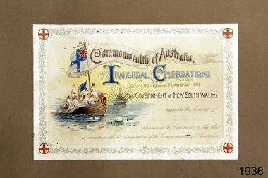 Flagstaff Hill Maritime Museum and Village
Document - Invitation, Government of New South Wales, Commonwealth of Australia Inaugural Celebrations, Bef. 01-01-1901
This is an Invitation to attend the Inaugural Celebrations of the Commonwealth of Australia, to celebrate the Federation of Australia's united Colonies. It was created on behalf of the Government of New South Wales. January 1st, 1901, is the official date of Australia's Federation. There is no recipient's name on the invitation. The illustrations on the invitation represent the Federation of Australian States, with their historic symbols carried on the sailing ship, representing the colonisation of Australia. The 'rising sun' possibly represents the rising of the young Australia. The Sough Australian symbol appears to be the historic seal of South Australia, depicting Britania meeting an Australian Aboriginal seated on the beach. The symbol was replaced in 1904. The Victorian symbol of a crown above the Southern Cross appears on the flag at the back of the ship, with a crown and the Southern Cross beside each other. The invitation was originally framed by G.U. Petterd, a picture framer and plush worker in Warrnambool, Victoria.The invitation holds great significance, representing a point in Australia's history when the British Colony became an independent nation, with the states uniting under a Federal government. The symbols on the invitation represent those used by each state at the time, many of which have evolved and changed since that time. The decorative and careful creation of the certificate represents the importance placed on the celebrations.Invitation; rectangular page printed in colour with text and illustrations, and attached to cardboard. The document has a floral border with a symbol in each corner. The illustration includes a wooden sailing ship with six figures with long fair hair wearing white robes, and holding six flags or symbols. The mast holds a swallow-tailed banner showing a flag and text. The invitation is from the Government of New South Wales, for the recipient to attend the inaugural celebrations in Sydney on 1st January 1901, for the official date of the Federation of Australia. There is a purple oval stamp on the revers with inscriptions. The picture was originally framed by G.U. Petterd, WarrnamboolSTAMP: "G.U. PETTERD, WARRNAMBOOL / PICTURE FRAMER & PLUSH / WORKER" TEST: - "Commonwealth of Australia. / INAUGURAL CELEBRATIONS / AT SYDNEY / COMMENCING on the 1st JANUARY 1901" "The GOVERNMENT of NEW SOUTH WALES / requests the honour of / (blank line) / presence at the Celebrations to take place / in connection with the inauguration of the Commonwealth of Australia" Symbols: - [white flag, blue cross, Union Jack] (Australian Federation Flag) [blue Maltese cross with crown in centre] (Queensland symbol) [red St George cross with a lion in the centre] (New South Wales symbol) [white with a symbol on one side (crown?) with a blue flag with Southern Cross on the other] (Victoria's symbols of Crown above Southern Cross) [red lion on white] (Tasmanian symbol) [black swan on yellow] (Western Australia badge) [two figures, one standing and one seated] (South Australian seal) and image of (rising sun on the horizon)flagstaff hill, flagstaff hill maritime museum and village, warrnambool, maritime museum, maritime village, great ocean road, shipwreck coast, invitation, commonwealth of australia, inaugural celebrations, sydney, 1st january 1901, 01-01-1901, federation of australia, australian states, government of new south wales, symbols, flags, australian colony, certificate, g.u. petturd, picture framer and plush worker, picture framer, plush worker, 1901 -
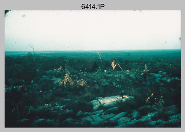 Bendigo Military Museum
Photograph - Royal Australian Survey Corps Surveyors in the Field – Northern Territory and Queensland, 1959 – 1960
This is a set of 10 photographs of surveyors and support staff in the field undertaking duties in the Northern Territory and North Queensland in 1959 – 1960. The surveyors were employed in the establishment of mapping and geodetic control. In this era surveyors used theodolites to observe horizontal and vertical angles and tellurometers to measure base line distances between survey stations. Laplace survey observations seen in Photo .1P was a series of precise observations carried out at geodetic survey stations to determine astronomic latitudes, longitudes and azimuths to achieve maximum precision in the survey network. Laplace observations were necessary in a geodetic network at every 6th survey station, however the National Mapping Council specified at this time the spacing would be ideally between 4-6 survey stations. The cairn shown in photo .4P was built by RASvy as a landmark over a trigonometric survey station. It was dismantled in 1960 to enable re-occupation and survey observations. It was not restored to the condition shown in the photo.This is a set of 10 photographs of surveyors and support staff in the field undertaking duties in the Northern Territory (NT) and Queensland (QLD) in 1959 – 1960. The photographs were printed on photographic paper and are part of the Army Survey Regiment’s Collection. The photographs were scanned at 300 dpi. .1) - Photo, colour, 1959. Tony Slattery occupying a Laplace survey station on a hill in the Mount Young area of the NT. .2) - Photo, colour, 1959. Surveyors’ camp in the Mount Young area of the NT, L to R: Spencer Snow and Tony Slattery. .3) - Photo, colour, 1959. Surveyors’ camp in the Peckman Hill area, near Katherine in the NT. .4) - Photo, colour, 1959. Cairn on Trig Hill, Borroloola, NT. Built by Spencer Snow, Tom Royle and Jack McCabe. .5) - Photo, colour, 1959. Survey party taking a break next to their Austin Champ vehicle, in transit between Katherine, NT and Wyndam WA. L to R: Tony Slattery, Dave Owens, John Van De Graff. .6) - Photo, colour, 1960. Surveyors’ camp between Mount Isa, QLD and Borroloola, NT. L to R: Pat Cox and John Van De Graff prepare their meal on an open fire. .7) - Photo, colour, 1960. Surveyor - Dennis Woods undertaking survey observations, using MRA1 tellurometer to measure base-line distances NW of Mount Isa, QLD. .8) - Photo, colour, 1960. Unidentified surveyors assessing recovery of their stalled Studebaker truck vehicle after attempting a water crossing in the NT. .9) - Photo, colour, 1960. Unidentified surveyor making batches of bread at a camp in the NT. Seen in the photo placing a lid with hot coals onto the camp oven. .10) - Photo, colour, 1960. Unidentified survey party occupying a survey station on a hill in the Mount near the Lawn Hill area, NW of Mount Isa, QLD. A MRA1 tellurometer to measure base-line distances appear on the right side of the photo. .9) - Photo, colour, 1960. Unidentified surveyors assessing recovery of their stalled Studebaker truck vehicle after attempting a water crossing in the NT. .10) - Photo, colour, 1960. Unidentified surveyor making batches of bread at a camp in the NT. Seen in the photo placing a lid with hot coals onto the camp oven. .1P to .10P annotated on back – personnel names, the year and the location. royal australian survey corps, rasvy, army survey regiment, asr, army svy regt, fortuna, surveying -
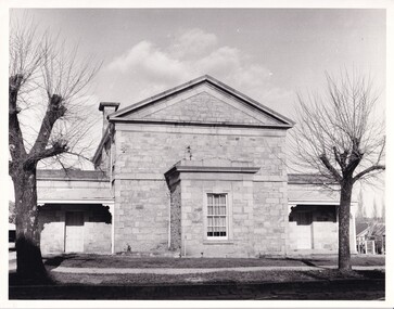 The Beechworth Burke Museum
Photograph, c1970
The Beechworth Historic Courthouse is a living history museum in Victoria, Australia. Built in 1858, it has been in continuous service for 131 years and is currently home to a unique collection of artifacts, including its original furniture and fittings. The Courthouse Law Library is also recognised as being of outstanding national significance with many rare books held in the collection. The courthouse was built in 1858 and is located in the centre of the Beechworth Historic Precinct. It was built from granite with a double height gabled courtroom with the entrance via a central projecting porch. The building was classified in 1959 as part of Group Classification (B2615)with Forests Office, Lands Office, Police Lock-up & Police Station. The Courthouse is a significant site in Australia’s legal history because it was the location of more than 40 trials and hearings for the Kelly Gang and their sympathisers.This a rectangular, black and white photograph, unmounted.Reverse Ministry of Tourism, Melbourne1850s beechworth, beechworth courthouse, ned kelly, 1800s beechworth, kelly gang, beechworth historic courthouse, 1858, kelly trials, daniel kelly, dan kelly, edward kelly, ellen kelly, elizabeth scott, the first woman hanged in victoria, colony of victoria, 1863, domestic violence related murder -
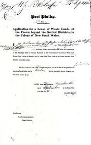 Phillip Island and District Historical Society Inc.
Document, Grant to W.J.McHaffie for lease of Crown land
J D McHaffie, Phillip Island's first leaseholder, relate how McHaffie set up his headquarters (and later built his house) alongside what is now known as McHaffies lagoon. The McHaffie brothers – John David and William – occupied Phillip Island under a license from the Admiralty in 1842 and farmed it as a sheep run.Historical3 A4 photocopies showing application for lease in 1850, size and description of the land and instructions for the application.w.j.mchaffie, land grant, farming, saltwater creek, crown land -
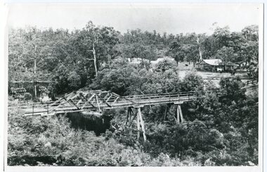 Orbost & District Historical Society
black and white photograph, c1920-1954
This is a copy of "THE BRIDGE AT BOGGY CREEK, NOWA NOWA, LAKE TYERS." which is a Rose Stereograph Co postcard. Boggy Creek Bridge was built in 1916 as part of the Bairnsdale to Orbost extension to the main Gippsland Railway, and is situated in the middle of the township of Nowa Nowa, crossing a steep-sided and well-timbered creek-valley. This section of the line closed in 1987. This bridge plays a major part in the identity and history of the town of Nowa Nowa, This item is associated with the East Gippsland Railway.A large black / white photograph of a large wooden bridge across a creek. There is a house and outbuildings in the background on the right. It is in a bush setting. on back - "Boggy Creek bridge - Nowa Nowa 1887 LaTrobe Collection"boggy-creek-bridge east-gippsland-railway -
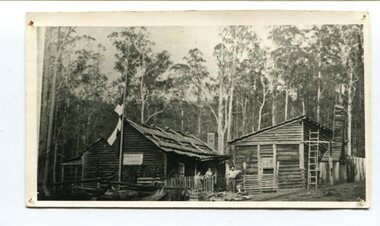 Orbost & District Historical Society
black and white photograph, late 19th century - early 20th century
Peter Jensen came to Martin's Creek (35 miles north of Orbost) in 1890 having been told that Martin's Creek would be on the railway line. He was a cooper who made the casks from silver wattles. He cleared the area for farming and then built an accommodation house, Danebo., which was well used by travellers to Bonang and Bendoc. . Gippsland was a relatively less developed part of Victoria in the nineteenth century. Danebo Hotel, Martin’s Creek, would have been an important stopping point for travellers to Bonang and Bendoc. The hotel is no longer standing A black / white photograph of a timber building - a house and another building at an angle. There are three people standing in front - a man. woman and child. On the left is a flag on a mast. In the background is bush.danebo-hotel-martins-creek jensen-peter -
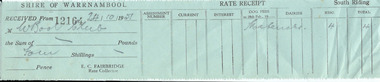 Warrnambool and District Historical Society Inc.
Document, Receipt WCC
This receipt issued to the Warrnambool Club by the Shire of Warrnambool is for ‘materials’ supplied. It is not known what type of material the Warrnambool Club was buying but it could not have been very important as the total cost was only four shillings. The Warrnamnbool Club was (and is) in the City of Warrnambool. This club was a gentlemen’s club established in 1873 and the building that still exists today was built in 1877. This receipt has little significance as it is a 1951 purchase by the Warrnambool Club for an unknown item of little value. This is a small green receipt slip issued by the Shire of Warrnambool in 1951 to the Warrnambool Club for materials received. The paper has printed black lines and handwritten information (pencil) and has been torn from a larger receipt book, perhaps leaving a copy for the Shire records. ‘Shire of Warrnambool, received from W’bool Club, the sum of four shillings, E.C.Fairbridge, Rate Collector, 24/10/51’.warrnambool club, shire of warrnambool -
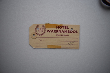 Warrnambool and District Historical Society Inc.
Label, Hotel Warrnambool, Early 20th century
The Hotel Warrnambool, the second in Warrnambool to have that name, was built on the site of the old Hotel Mansions (Ozone Coffee Palace / Ozone Hotel) which was destroyed by fire in 1929. The Hotel Warrnambool was opened in 1931 using the licence transferred from the Hotel Mansions. It has played a major role in the social and economic life of the city since this time.This luggage label from the Hotel Warrnambool is of some historical significance as the hotel is a prominent one in Warrnambool today built on the site of the Hotel Mansions regarded as the finest building ever to be erected in Warrnambool. Buff coloured rectangular label with maroon text. Two corners of the card are mitred. The label features a open ended wreath with the letters WH entwined in its centre. There are three punched holes , one with a reinforce sticker. Two pieces of adhesive tape are attached on the top and the bottom. HOTEL WARRNAMBOOL WARRNAMBOOL( In smaller font). Mr. ..... 1960 (in pencil) hotel warrnambool, ozone coffee palace, ozone hotel, warrnambool -
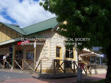 Eltham District Historical Society Inc
Photograph - Digital Photograph, Marguerite Marshall, Post Office, Hurstbridge, 27 September 2007
The Post Office building was built in 1918 by printer, Robert Charles Harris, owner of The Evelyn Observer newspaper. In 2007 a Post Office, cafe and giftshop operated from here. Covered under Heritage Overlay, Nillumbik Planning Scheme. Published: Nillumbik Now and Then / Marguerite Marshall 2008; photographs Alan King with Marguerite Marshall.; p13This collection of almost 130 photos about places and people within the Shire of Nillumbik, an urban and rural municipality in Melbourne's north, contributes to an understanding of the history of the Shire. Published in 2008 immediately prior to the Black Saturday bushfires of February 7, 2009, it documents sites that were impacted, and in some cases destroyed by the fires. It includes photographs taken especially for the publication, creating a unique time capsule representing the Shire in the early 21st century. It remains the most recent comprehenesive publication devoted to the Shire's history connecting local residents to the past. nillumbik now and then (marshall-king) collection, hurstbridge, post office, post office cafe -
Glen Eira Historical Society
Letter - Glen Eira Road, 258, Elsternwick, E. K. Motors
A typed letter from National Trust of Australia (Victoria) dated 04/07/1996 to E. K. Motors 258 Glen Eira Road, Elsternwick notifying that the above building built in 1935 has been classified in the National Trust’s Register, as a good example of service stations of the period. A typed copy of the National Trust Report is included.cuthbertson eric. s., klein e., tudor service station, cuthbertson sarah, klein k., petrol stations, cuthbertson eric, ek motors, e.k. motors, glover service station, swinnerton hedley fraser, glen eira road, tudor garage, glover robert, elsternwick, glover garage, architectural styles, glen huntly road, everett corner service station, hawthorn road, alma road, north caulfield, caulfield, dack and armstrong -
Glen Eira Historical Society
Document - Elizabeth Street, 30, Elsternwick, formerly Trengrove
A three page copy of a Caulfield Conservation Study by Andrew Ward, date 09/1994, on the existing house and previous house built at 30 Elizabeth Street. The study includes an architectural description of the house, a brief history of property ownership, a statement of significance and two black and white photographs (101 mm x 154mm) of the exterior of the house.trengrove, elizabeth street, ripponlea estate, bent thomas, smith joseph, sargood frederick sir, art deco, architectural features, architectural styles, georgian revival style, house names -
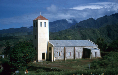 Federation University Historical Collection
Slide, Eglise du Bras de Pontho (Church of the Holy Angels of Bras de Pontho), c1970
A small wooden chapel was built on this site but was destroyed by a cyclone in 1948. It was immediately replaced by the present church, which has simple architecture and interior ornaments. The concrete building is a large rectangle to which is added a square tower supporting a small bell tower. From the church site you can view the Bras de la Plaine valley Photograph of a church Handwritten "Eglise du Bras de Pontho" Stamped "R. Ueberschlag"eglise du bras de pontho, church of the holy angels of bras de pontho, church, bras de la plaine valley -
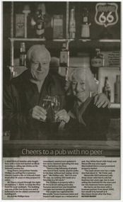 Marysville & District Historical Society
Newspaper (Item) - Newspaper article, Jay Town, Cheers to a pub with no peer, Unknown
A newspaper article regarding the selling of The Crossways Historic Inn in Marysville. The Crossways was built in the early 1920s and is the oldest building in Marysville. The Crossways historic inn survived the 2009 Black Saturday bushfires thanks to the efforts of its c-owner Greg Cherry and, in the days after the fires, provided a much-needed refuge to the Marysville community and firefighters. A newspaper article regarding the selling of The Crossways Historic Inn in Marysville.marysville, victoria, australia, the crossways cabaret, the crossways, crossways, crossways country inn, crossways historic inn, 2009 black saturday bushfires, accommodation, newspaper article -
 Phillip Island and District Historical Society Inc.
Photograph, The "Speke", 1906 (original photograph)
One of a collection of 6 photographs donated by Anne Grayden. The Speke was the third largest 3 masted ships built in 1891. It was wrecked in 1906 near Kitty Miller Bay due to a navigational error. One man drowned but the rest of the crew reached safety. Remains of the hull are a tourist attraction now over 100 years later.Black & White photograph of the wreck of the Speke. The shop is listing but still in one piece. It is in the water seemingly stuck on rocks.the speke, wreck of the speke, phillip island ship wrecks, anne grayden -
![Document - Financial Record, List of contributors to the erection of a Church at St Helena [1870], 26/12/1870](/media/collectors/4f729f5697f83e03086015b8/items/642f7f7f5b24c91f3fba7060/item-media/64391738cf5c8fe9d334a315/item-fit-380x285.jpg) Greensborough Historical Society
Greensborough Historical SocietyDocument - Financial Record, List of contributors to the erection of a Church at St Helena [1870], 26/12/1870
A list of contributors to the erection of St Katherine's Church St Helena. Major contributor was Anthony Beale senior who originally built the Church in memory of his wife Katherine Beale; other contributors include Elizabeth James, Katherine Burl, Katharine Halliburton, C. S. Wingrove, Anthony Beale, Charles Maplestone, Hinkins (no further details).Photocopy of document, 1 page.st helena, st katherine's church st helena, anthony beale -
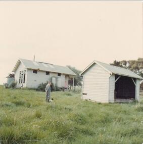 Phillip Island and District Historical Society Inc.
Photograph, 1978 - 79
The Ventnor School had its beginning in the Ventnor Hall, which was built by parents of the children. It was opened on 5th May 1915 and Miss Ruby Bright was the first Head Teacher. Later an area was purchased from Mr Thomas Jones and a new school was erected at a cost of £790.2.6. The school was occupied on 6th September 1923 and was un staffed in 1964.Photograph of old Ventnor State School No. 3895 and Shelter Shed. Man with dog in foreground.local history, photographs, buildings - historical, schools, coloured photograph, john cook, phillip island, ventnor state school -
![Photograph - Digital Image, Ray White Greensborough, 3 St Helena Road Greensborough [exterior], 2017_](/media/collectors/4f729f5697f83e03086015b8/items/5d3bfe1621ea6715d01b253f/item-media/5d3bfe3821ea6715d01b5585/item-fit-380x285.jpg) Greensborough Historical Society
Greensborough Historical SocietyPhotograph - Digital Image, Ray White Greensborough, 3 St Helena Road Greensborough [exterior], 2017_
Exterior photographs of the house at 3 St Helena Road Greensborough (corner Diamond Creek Road). The house was built in 1920. These photographs are from the Ray White sales brochure 2017. The 4 bedroom property sold in December 2017 for $900,000; previous sales: April 2009, $600,000; June 1981, $36,500; June 1976, $32,500. Digital copy of 5 colour photographs, possibly taken from a drone.st helena road greensborough, diamond creek road greensborough