Showing 13843 items matching "tasmanian-built"
-
 Greensborough Historical Society
Photograph - Digital Image, Marilyn Smith, Mernda Station 2018, 27/09/2018
In 2018 GHS members visited Turner's Bakery in Mernda for lunch and continued on to visit historic sites remaining in the Mernda area. This photograph shows the newly built Mernda Station, part of the railway extension on the old Epping line. This station was opened in August 2018. Mernda is now the end of the line. It is sited on corner Bridge Inn Road and Schotters Road. Mernda is an area of rapid modern growth with a few remaining historic buildings dating from the 19th century.Digital copy of colour photographmernda, mernda historic sites, schotters road mernda, mernda station, bridge inn road mernda -
![Photograph - Digital Image, Ray White Greensborough, 3 St Helena Road Greensborough [bedrooms and bathrooms], 2017_](/media/collectors/4f729f5697f83e03086015b8/items/5d3c00e921ea6715d01e47d8/item-media/5d3c011d21ea6715d01e7d3e/item-fit-380x285.jpg) Greensborough Historical Society
Greensborough Historical SocietyPhotograph - Digital Image, Ray White Greensborough, 3 St Helena Road Greensborough [bedrooms and bathrooms], 2017_
Interior photographs of the house at 3 St Helena Road Greensborough (corner Diamond Creek Road), showing the bedrooms and bathroms. The house was built in 1920. These photographs are from the Ray White sales brochure 2017. The 4 bedroom property sold in December 2017 for $900,000; previous sales: April 2009, $600,000; June 1981, $36,500; June 1976, $32,500. Digital copy of 4 colour photographs.st helena road greensborough, diamond creek road greensborough -
 Greensborough Historical Society
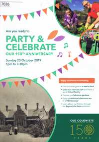
Pamphlet, Leith Park Celebration Day 2019 program, 20/10/2019
A celebration for the 150th anniversary of the establishment of the first Old Colonists Association of Victoria retirement village at Rushall Park North Fitzroy was held on 20 October 2019 at Leith Park St Helena. Leith Park was the Association's second village, built in the 1960s on land donated by Arthur C. Leith, Life Governor, Councillor and President of the Association 1949-1972.4 p. colour pamphlet printed on light cardboardleith park retirement village, old colonists association -
 Glenelg Shire Council Cultural Collection
Book, Halstead Press, Wreck of the Admella, 1966
Blue hard-copy book. Gold text on spine. Two double-sided pages of black & white photos half way through book. Book has dust jacket with coloured reproduction of a painting of the wreck of the Admella, by Charles Hill. Photo of author inside back of dust jacket.admella, portland lifeboat, book -
 Greensborough Historical Society
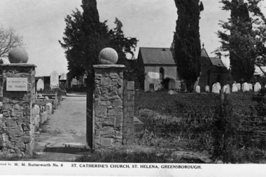
Photograph - Digital Image, St Helena Cemetery, 1930s
St Katherine’s Church St Helena, entry gates with Church in background. St Katherine’s Church was built in 1856 (known as the Rose Chapel after the wife of Major Anthony Beale, Katherine Rose Beale). The Church was destroyed by fire in 1957 then restored. The Cemetery was initially the burial place of the Beale family but now approximately 200 people are buried there. [Studio: Butterworth]Digital copy of black and white photograph.st katherines church, rose chapel, anthony beale, katherine rose beale -
 Greensborough Historical Society
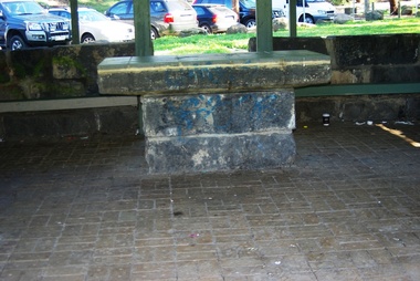
Photograph - Digital Image, Pioneer Reserve 2014 -2, 01/10/2014
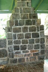
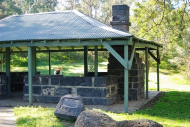
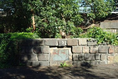
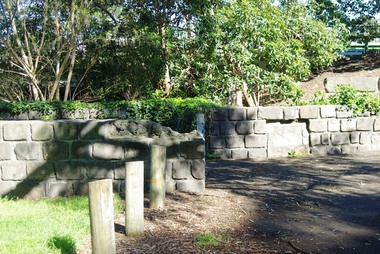
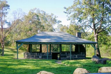
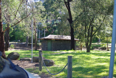
Pioneer Reserve, Greensborough is a small park on the corner of St Helena and Diamond Creek Roads. It is adjacent to the site of Greensborough's first bridge across the Plenty River, c. 1864 - 1960s. The shelter, viewing platform, retaining wall and entrance are built from the bridge's massive bluestone arched abutments dismantled between 1974 and 1983. Photograph by Marilyn Smith 2014.Digital copy of colour photograph.pioneer reserve greensborough -
 Greensborough Historical Society
Photograph - Digital Image, Pioneer Reserve 2014 -3, 01/10/2014
Pioneer Reserve, Greensborough is a small park on the corner of St Helena and Diamond Creek Roads. It is adjacent to the site of Greensborough's first bridge across the Plenty River, c. 1864 - 1960s. The shelter, viewing platform, retaining wall and entrance are built from the bridge's massive bluestone arched abutments dismantled between 1974 and 1983. Photograph by Marilyn Smith 2014.Digital copy of colour photograph.pioneer reserve greensborough -
 Greensborough Historical Society
Photograph - Digital Image, Pioneer Reserve 2014 -4, 23/09/2014
Pioneer Reserve, Greensborough is a small park on the corner of St Helena and Diamond Creek Roads. It is adjacent to the site of Greensborough's first bridge across the Plenty River, c. 1864 - 1960s. The shelter, viewing platform, retaining wall and entrance are built from the bridge's massive bluestone arched abutments dismantled between 1974 and 1983. Photograph by Marilyn Smith 2014.Digital copy of colour photograph.pioneer reserve greensborough -
 Greensborough Historical Society
Photograph - Digital Image, Pioneer Reserve 2014 -5, 23/09/2014
Pioneer Reserve, Greensborough is a small park on the corner of St Helena and Diamond Creek Roads. It is adjacent to the site of Greensborough's first bridge across the Plenty River, c. 1864 - 1960s. The shelter, viewing platform, retaining wall and entrance are built from the bridge's massive bluestone arched abutments dismantled between 1974 and 1983. Photograph by Marilyn Smith 2014.Digital copy of colour photograph.pioneer reserve greensborough -
 Greensborough Historical Society
Photograph - Digital Image, Pioneer Reserve 2014 -6, 23/09/2014
Pioneer Reserve, Greensborough is a small park on the corner of St Helena and Diamond Creek Roads. It is adjacent to the site of Greensborough's first bridge across the Plenty River, c. 1864 - 1960s. The shelter, viewing platform, retaining wall and entrance are built from the bridge's massive bluestone arched abutments dismantled between 1974 and 1983. Photograph by Marilyn Smith 2014.Digital copy of colour photograph.pioneer reserve greensborough -
 Greensborough Historical Society
Photograph - Digital Image, Pioneer Reserve 2014, 23/09/2014
Pioneer Reserve, Greensborough is a small park on the corner of St Helena and Diamond Creek Roads. It is adjacent to the site of Greensborough's first bridge across the Plenty River, c. 1864 - 1960s. The shelter, viewing platform, retaining wall and entrance are built from the bridge's massive bluestone arched abutments dismantled between 1974 and 1983. Photograph by Marilyn Smith 2014.Digital copy of colour photograph.pioneer reserve greensborough -
 Greensborough Historical Society
Photograph - Digital Image, Pioneer Reserve 2014 -8, 23/09/2014
Pioneer Reserve, Greensborough is a small park on the corner of St Helena and Diamond Creek Roads. It is adjacent to the site of Greensborough's first bridge across the Plenty River, c. 1864 - 1960s. The shelter, viewing platform, retaining wall and entrance are built from the bridge's massive bluestone arched abutments dismantled between 1974 and 1983. Photograph by Marilyn Smith 2014.Digital copy of colour photograph.pioneer reserve greensborough -
 Greensborough Historical Society
Photograph - Digital image, Marilyn Smith, Ellis Cottage, May 2016: Interior Display of artefacts, 27/05/2016
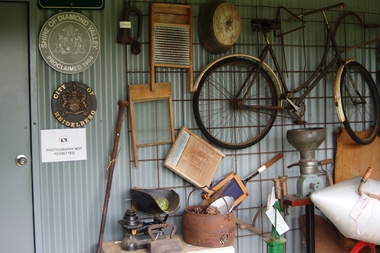
In May 2016, the Nillumbik Historical Society invited Greensborough Historical Society to visit its historical centre at Ellis Cottage in Diamond Creek. Ellis Cottage was built in 1865 and is made of local uncut stone. The cottage is a typical farmers residence of this period. The stone construction is unique in this district as most construction is weatherboard. This photo shows some of the artefacts on display.Digital colour photographellis cottage, nillumbik historical society inc. -
 Greensborough Historical Society
Photograph - Digital image, Marilyn Smith, Ellis Cottage, May 2016: Sculpture in Grounds, 27/05/2016
In May 2016, the Nillumbik Historical Society invited Greensborough Historical Society to visit its historical centre at Ellis Cottage in Diamond Creek. Ellis Cottage was built in 1865 and is made of local uncut stone. The cottage is a typical farmers residence of this period. The stone construction is unique in this district as most construction is weatherboard. This photo shows a sculpture in the grounds of the Ellis Cottage.Digital colour photographellis cottage, nillumbik historical society inc. -
 Greensborough Historical Society
Photograph - Digital image, Marilyn Smith, Ellis Cottage, May 2016: Exterior and Garden, 27/05/2016
In May 2016, the Nillumbik Historical Society invited Greensborough Historical Society to visit its historical centre at Ellis Cottage in Diamond Creek. Ellis Cottage was built in 1865 and is made of local uncut stone. The cottage is a typical farmers residence of this period. The stone construction is unique in this district as most construction is weatherboard. This photo shows the exterior and garden of Ellis Cottage.Digital colour photographellis cottage, nillumbik historical society inc. -
 Greensborough Historical Society
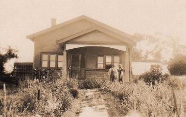
Photograph - Digital Image, Cherel Sartori, Kell's Cottage, 01/01/1956
Photograph of Kell's Cottage. The house was built 1917, at 112 Henry Street Greensborough by William Mitchell on the 60 acre dairy farm owned by Ethel and Walter Kell. This collection of photographs was copied by Cherel Sartori (who owned the house from 1990-2000), following a visit by Claude Amiet who lived in the house as a child in the early 20th century.Digital copy of black and white photographkell's cottage, claude amiet, cherel sartori -
 Greensborough Historical Society
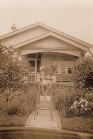
Photograph - Digital Image, Cherel Sartori, Kell's Cottage 1940s, 01/01/1956
Photograph of Kell's Cottage in the 1940s. The house was built 1917, at 112 Henry Street Greensborough by William Mitchell on the 60 acre dairy farm owned by Ethel and Walter Kell. This collection of photographs was copied by Cherel Sartori (who owned the house from 1990-2000), following a visit by Claude Amiet who lived in the house as a child in the early 20th century.Digital copy of black and white photographkell's cottage, claude amiet, cherel sartori -
 Greensborough Historical Society
Photograph - Digital Image, Cherel Sartori, Kell's Cottage, 01/01/1956
Photographs of Kell's Cottage in the 1940s. The house was built 1917, at 112 Henry Street Greensborough by William Mitchell on the 60 acre dairy farm owned by Ethel and Walter Kell. This collection of photographs was copied by Cherel Sartori (who owned the house from 1990-2000), following a visit by Claude Amiet who lived in the house as a child in the early 20th century.Digital copy of 3 black and white photographkell's cottage, claude amiet, cherel sartori -
 Greensborough Historical Society
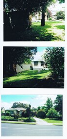
Photograph - Photographs, 104 Nell Street Greensborough, c1990
Photographs of 104 Nell St Greensborough c 1990. Caption: "This was the original house at 104 Nell Street Greensborough. Just west of Henry Street the house was demolished and a new brick home was built by Craig and Diane Herman, descendants of original home owners. Craig and Diane and kids have been GHS members and are local to cricket and footy umpiring."3 Colour Photographs with captionnell street greensborough, greensborough houses, herman family -
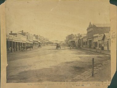 Ararat & District Historical Society (operating the Langi Morgala Museum)
Barkly Street, Ararat, perhaps 1870s
This is one of a dozen or so pictures of very early Ararat held by Langi Morgala Museum, and can be compared to a succession of later photographs to illustrate the growth of the town of Ararat. The date suggested by the inscription on the front is probably a reference to some other occurrence, since the street seems far to built-up for 1856-1860. The date is more likely the 1870s, or even the 1880sThis photograph, though not in good condition, is one of the few in the possession of Langi Morgala Museum that shows very early Ararat. It is of regional significance, which would be enhanced if a firmer date could be established. This cardboard-mounted large photograph is not in very good condition, but some parts of the image are still clear. There are permanent inscriptions on both front and back, not done in sympathy with the age and importance of the item.On front: "Note hitching posts and the old Turf Hotel, Barkly Street cont[illegible] / 1856-60". On back: museum stamp and photo numbers.barkly-street, ararat, horse, horse-driven, early-ararat, business, commercial -
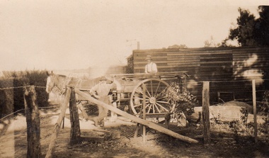
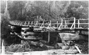 Eltham District Historical Society Inc
Negative - Photograph, Log bridge over Pheasant Creek, Kinglake, c.1920
Horse and cart with driver Mr. F. Thomson and passenger cross a wooden bridge with log tree trunk base construction supported by timber rails over Johnstone's Creek amidst the Kinglake forest. The bridge was built for the timber tramline. There was also a logging district in the Pheasant Creek area just outside the Shire of Eltham. Note dog also sitting on bridge.This photo forms part of a collection of photographs gathered by the Shire of Eltham for their centenary project book,"Pioneers and Painters: 100 years of the Shire of Eltham" by Alan Marshall (1971). The collection of over 500 images is held in partnership between Eltham District Historical Society and Yarra Plenty Regional Library (Eltham Library) and is now formally known as 'The Shire of Eltham Pioneers Photograph Collection.' It is significant in being the first community sourced collection representing the places and people of the Shire's first one hundred years.Digital image 4 x 5 inch B&W Neg 120 format B&W negative (spare) 2 x printsbridge, f. thomson, kinglake, log bridge, mr. munro, pheasant creek, pioneers and painters, shire of eltham pioneers photograph collection, timber tramway -
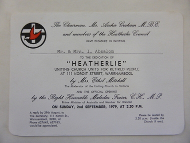 Warrnambool and District Historical Society Inc.
Document - Invitation, Heatherlie Homes opening 1979, Circa August 1979
"Heatherlie " homes have been extended and are still operated under the auspices of the Uniting Church Australia. Invitation retained by Absalom family members for 44 years. "Heatherlie" name originated from owners of wooden house built by EB Phillips, furniture store owner. Name taken from mrs Annie Phillips (nee Bone) family home in Stawell.Original document, invitation to dedication of "Heatherlie" by Mrs Ethel Mitchell, Moderator of Uniting Church in Victoria and the official opening By the R Hon Malcolm Fraser, PM of Australia and Member of Wannon. Significant as "Heatherlie" was a community and government funded building programRectangular white card with rounded corners. Black print with black and red logo, Uniting Church. Typewritten name, Mr. & Mrs. I. Absalom. Varied size print, copperplate, capital letters and typewritten name inserted.Logo of Uniting Churchmr archie graham, mr & mrs i absalom, uniting church, warrnambool, mrs ethel mitchell-moderator, malcolm fraser pm, of australia, koroit street, heatherlie council -
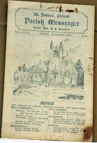 Orbost & District Historical Society
newsletter, St James, Orbost Parish Messenger November, 1933, November 1933
St. James' Anglican Church, Orbost, was conceived and built as a memorial to the men 'who served and suffered during the Great War' as noted on the foundation stone. The Right Reverend GH Cranswick, DD, Bishop of Gippsland, laid the stone on 1 October 1927. This parish newsletter was published regularly to inform church members of all the latest news, events and information.For many years the Anglican people of Orbost have enjoyed the fellowship of the church and the children, in particular, were socially and spiritually involved. This item is reminiscent of the first half of the 20th century when church-going was more common.A four page newsletter titled, Parish Messenger for Orbost, November 1933, Vol 6 -No 83. It lists the services, times, meetings and news. The rector at the time was Rev. K.E. Hamilton.st-james-anglican-church church newsletter -
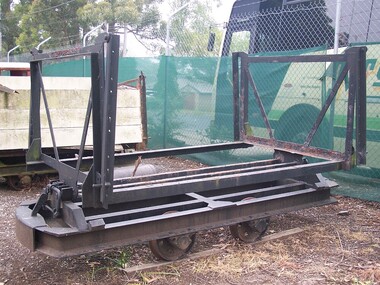 Puffing Billy Railway
Cheetham Salt Hopper Truck No12
Trucks of this type were built to carry salt from the saltpans of Cheetham Salt Company works, at Laverton, Moolap and Geelong. Made from wood and steel, it was found that the wood would not erode as much as steel from the salt and this is the reason these vehicles have metal on the exterior of the wagon. Later new stainless steel hopper trucks were used at the works. Historic - Industrial narrow Gauge railway - Cheetham Salt Company at Laverton, Moolap and Geelong.Two Cheetham Salt Hopper Trucks Gauge 2'0" Made from Wood & Steel No. 12 on metal frame of one of the Cheetham Salt Hopper truck A second hopper truck is not numbered.puffing billy, industrial narrow gauge railway, cheetham salt company, gauge 2' 0", salt -
 Puffing Billy Railway
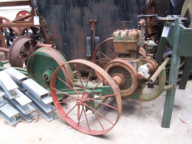
Tool - Drag Saw, New Record Drag Saw, circa 1920s
Circa 1920s petrol driven cross saw. It was mainly used cross cutting felled logs The Land on which the Menzies Creek railway station and Museum are built on was once apart of James Hermon's & his son William Hermon's property on which this Drag Saw was used. reference : Jinkers and Whims: A Pictorial History of Timber-Getting By Jack BradshawHistoric - Industrial Timber working petrol driven cross saw - Drag SawLarge, mechanical saw mounted on a steel shaft connected to tin fuel and water containers. The machine has two large spoked wheels, a rotating Crankshaft and an extended arm/rod attached to a crank and flywheel.New Record puffing billy, drag saw, timber cutting, early mechanical equipment, james hermon & sons, menzies creek, 1920s -
 Hume City Civic Collection
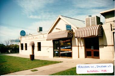
Photograph, 1/10/1988
The Ball Court Hotel was built in the late 1870's by John Cahill. It remained with the Cahill family until World War 2. The Lupson family were the hoteliers for 20 years after WW2 and in 1973 the McPhersons rebuilt the interior and added air conditioning to the building. The Ball Court Hotel is the only surviving hotel from Sunbury's early settlement.A coloured photograph of the side view along Macedon Street of the Ball Court Hotel showing the public bar in the original building, the Take-away area and the bistro. There are three windows and a door in the original building. The take-away section has a shop front facade and the bistro entrance has two double glass doors. All doorways are covered with a cantilever brown and white canvas awning. A footpath and grassed nature strip is outside the building. 3 blue and white brewery signs are along the side of the building and 2 air conditioning units are on the roof.In Gothic lettering 'BALL COURT HOTEL'hotels, cahill, john, mcpherson, mr and mrs, lupson, fred, ball court hotel, george evans collection -
 Hume City Civic Collection
Photograph, Mid 1990's
The building suppliers and the Sunbury CFA were sited at the northern end of Evans Street and in the past were away from the main shopping centre. As Sunbury expanded and Sunbury Shopping Square was built on the opposite side of Evans Street, the building suppliers closed down and the CFA depot was moved out of the town centre to two other locations to avoid traffic conjestion.A coloured photograph of the east side of Evans Street showing the building suppliers yard and the Sunbury CFA station and towers. The road in the foreground has been marked out for angle parking. There is a metal pole on the extreme RHS of the photograph.building suppliers, shopping centres, sunbury country fire authority (cfa), evans street, george evans collection -
 Hume City Civic Collection
Photograph, late 1980s
This is a photograph of the site and the remains of the Lochton flour mill which was situated on a horse shoe bend along Deep Creek at Bulla. Captain William Morrison Hunter took up land along Deep Creek and built his home in 1850.He opened the flour mill in 1856, which was worked by a number of millers until it ceased operations in 1961.Flour milling was one of the early industries carried out in the Sunbury and Bulla district. The mills were established along Jacksons Creek in Sunbury and Deep Creek in Bulla.A coloured photograph of a tree lined horseshoe bend in a river with the remains of a bluestone building in the bottom RH corner.lochton flour mill, bulla, flour mills, captain william morrison hunter -
 Rutherglen Historical Society
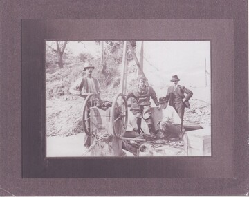
Image
Extracts from the entry for the bridge in the Victorian Heritage Database: "The bridge is of also of historical significance for its association with the prominent local identity and pioneer businessman John Foord, who was involved in the company that erected the 1862 timber bridge on the site. ... When the new bridge was built as a replacement, it took the same name." This second bridge (the current one) was opened in January 1893, Photocopy of a photograph of four men, one in old style diving suit. Copy is mounted on board made of what appears to be a thin layer of Styrofoam sandwiched between two layers of glossy paper.Written on back of mount: "During building of 2nd John Foord Bridge"john foord, bridge construction, diving, corowa, wahgunyah -
 Whitehorse Historical Society Inc.
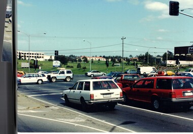
Photograph, Springvale Road East Burwood
The Tally Ho Business Park was built on vacant land previously owned by the Methodist Church. The land was sold cheaply to the Church by Abel Hoadley, and the Tally Ho Boys Home was erected there. A change in the care of the boys meant that the land became vacant for a considerable time before buildings appeared. The Country Fire Authority, Vic Roads and World Vision are also located there.4 coloured photographs (a-d) taken at the intersection of Springvale Road & Burwood Hwy East Burwood. First stages of the Tally Ho Business Park in the background.tally ho business park, businesses