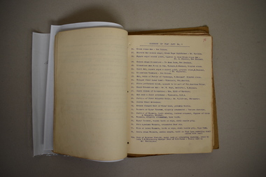
Showing 3893 items matching " council buildings"
-
 Ringwood and District Historical Society
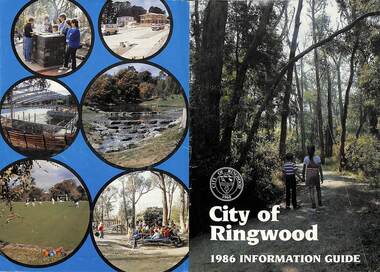
Booklet, City of Ringwood 1986 Information Guide, 1986
Community information booklet issued by City of Ringwood for 1986 - covering the facilities and activities of the Ringwood Council and other local organisations and associations. Cover photographs: Front - Wombalano Park; Back L-R - Barbecue at Ringwood Lake, Housing construction at Ringwood, Enclosing swimming centre, Water cascade at rear of Ringwood Lake, Croquet at Jubilee Park, Playground at Ringwood Lake.CONTENTS: (page no.) After School Care Programme 30 & 31 Amalgamations 16 Aquatic Centre 14 & 15 Building Information 22 By-Law and Traffic Regulations 23 Chief Executive Message I0 Churches 38 Civic Centre 4 Committees of Council 5 Community Plan 12 & 13 Construction Work 34 Council Meeting Dates 4 Council Representatives 8 Councillors 6 & 7 Disabled Persons Facilities 41 Eastern Corridor Road Action Plan 17 Emergency Telephone Nos. 63 European Wasps 27 Family Day Care 30 Finances 18 Golf Course 22 Health 20 Historical Research Group 44 Home Help 33 Hospitals 45 Immunisations 2 i Incinerators 34 Infant Welfare Centres 45 Knaith Road Child Care Centre 30&31 Library 24 Local Area Traffic Management 17 Management Executive 11 Mayoral Message – Cr. W.R. (Bill) Wilkins, J.P. 3 Meals on Wheels 32 Members of Parliament 9 North Ringwood Senior Citizens 29 Parks for People 28 Playgroups 49 Pre-Schools 50 Rates 19 Rubbish — See Waste Ringwood District Centre 16 Schools 52 Swimming Pool — See Aquatic Centre 14 & 15 Waste 26rinx -
 Ringwood and District Historical Society
Booklet, Impact Printing (Vic.) Pty. Ltd, City of Ringwood 1987 Community Information Guide, 1987
Community information booklet issued by City of Ringwood for 1987 - covering the facilities and activities of the Ringwood Council and other local organisations and associations. Cover photograph: Ringwood Aquatic Centre at night. Middle page photographs: (from top L-R) Putting at Golf Course, Reclaimation work Mullum Mullum Creek, Poppett Head rear of Ringwood Lake, Wattle in bloom. (Middle row) Aquatic Centre Toddlers Pool, Fern Gallery at Lake, Aquatic Centre Diving Tank, Wedding at Ringwood Lake. (Bottom row) Lawn Bowls, Bike Path, Community Garden. Also includes lift-out City of Ringwood map.CONTENTS: (page no.) After School Care Programme 29 Aquatic Centre 12 & 13 Building Information 19 By-Law and Traffic Regulations 21 Chief Executive Message 10 Children's Services 28 Churches 40 Civic Centre 4 Committees of Council 5 Community Plan 11 Community Services 37 - 59 Construction Work 26 Council Elections 19 Council Meeting Dates 4 Council Representatives 8 Councillors 6 & 7 Disabled Persons Facilities 43 Domiciliary Care 30 Emergency Telephone Nos. 62 Family Day Care 28 Finances 16 Garbage 36 Golf Course 23 Health 25 Home Help 31 Immunisations 24 Incinerators 20 Infant Welfare Centres 45 Joint Use Facilities 35 Knaith Road Child Care Centre 28 & 29 Local Area Traffic Management 18 Management Executive 11 Mayoral Message – Cr. Lillian Rosewarne, J.P. 3 Meals on Wheels 30 Members of Parliament 9 Parks 23 Playgroups 53 Pre-Schools 53 Rates 17 Recycling 35 & 36 Ringwood By-Pass Road 15 Ringwood Convention and Performing Arts Centre 34 Ringwood District Centre 14 Schools 52 Swimming Pool - See Aquatic Centre 12 & 13 Town Planning 19 Vandalism 27 rinx -
 Ringwood and District Historical Society
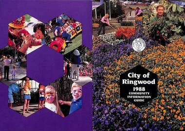
Booklet, City of Ringwood 1988 Community Information Guide, 1988
Community information booklet issued by City of Ringwood for 1988 - covering the facilities and activities of the Ringwood Council and other local organisations and associations. Cover photographs: Front - Floral displays at Clock Tower and a scene at Council nursery; Back - Activities at Ringwood Festival held at Ringwood Lake in April each year.CONTENTS: (page no.) After School Activities Programme 23 Aged Services 21 Bicentennial 15 Building Information 29 By-Laws and Traffic Regulations 31 Caravans/Mobile Homes 31 Chief Executive's Message 10 Children's Services 22 Churches 40 Civic Centre 4 Committees of Council 5 Community Plan 15 Community Services 35 Corporate Management Structure 11 Council Meeting Dates 4 Council Representatives 8 Councillors 6 & 7 Disabled Persons Facilities 42 Dogs 31 Domiciliary Care 24, 25 & 26 Elderly Day Care 44 Elderly Persons Units 29 Emergency Telephone Numbers 53 Employment Opportunities in Ringwood 26 European Wasps 28 Family Day Care 22 Finances 17 Fire Hazards 31 Future Leaders 16 Golf Course 34 Home Handyman Services 25 Home Help 26 Immunisation Programme 27 Incinerators 32 Knaith Road Child Care Centre 22 & 23 Library 30&31 Maternal & Child Health Centre 30 Mayoral Message – Cr. John R. Caffyn 3 Meals on Wheels 24 Members of Parliament 9 Playgroups 33 Pre-Schools 53 Primary Arterial Road Network in Ringwood 13 Rates—New Collection Service 18 & 19 Ringwood Aquatic Centre 14 & 15 Ringwood Bypass Road 12 Ringwood Convention & Performing Arts Centre 33 Ringwood District Centre Structure Plan 12 Rubbish Collection Service 35 & 36 Schools 56 Youth Outreach Worker 20 rinx -
 Ringwood and District Historical Society
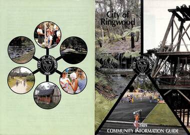
Booklet, City of Ringwood 1989 Community Information Guide, 1989
Community information booklet issued by City of Ringwood for 1989 - covering the facilities and activities of the Ringwood Council and other local organisations and associations. Cover photographs: Front - Fern Gully at Ringwood Lake, Poppett Head at rear of Lake, Athletics Track. Back - Highland Carnival, Wombalano Park, Miners Cottage at Ringwood Lake, Bike Path, Water Cascade at rear of Lake.CONTENTS: (page no.) 1. COUNCIL SERVICES After School Activities Programme 29 Aged Services 31, 32 & 33 Aquatic Centre 20 & 21 Budget 14 Building Information 16 By-Laws 26 Chief Executive's Message 9 Children's Services 29 Civic Centre 4 Committees of Council 5 Common Questions 36 Community Plan 10 & 11 Council Meeting Dates 4 Council Representatives 8 Councillors 6 & 7 Dogs 26 Dual Occupancy 12 Emergency Telephone Numbers 63 Family Day Care 29 Fire Hazards 27 Garbage 34 & 35 Golf Course 24 Home Handyman Services 31 Home Help 31 Incinerators 26 Knaith Road Child Care Centre 29 Library 23 Maternal and Child Health 28 Mayoral Message – Cr. R. Gardini 3 Meals on Wheels 31 Members of Parliament 62 Parks and Gardens 18 Rates 25 Residential Development Provisions 12 & 13 Ringwood Bypass Road 13 Ringwood Convention Centre & Performing Arts Centre 22 Ringwood District Centre 14 Staff 10 Town Planning 17 Works Depot 30 Youth Outreach Worker 33 2. LOCAL COMMUNITY SERVICES Accommodation 37 Alcoholism 37 Birthright 38 Blind 38 Care Force 39 Catholic Family Welfare Bureau 39 Central Ringwood Community Centre 39 Childbirth and Parenting Association 39 & 40 Churches 40 & 41 Community Services Victoria 42 Day Centres and Drop In Centres 43 Do Care 43 Drugs 43 Elderly Day Care 44 Emergency Housing 45 Family Planning Services 45 Financial Counselling 46 Hearing Aid Service 47 Hospitals 47 Housing 48 Information 48 Legal 49 Literacy 50 Lone Parents 50 Marriage Celebrants 50 Maroondah Social Health Centre 51 Neighbourhood Mediation Centre - Outer East 51 North Ringwood Community House 52 Nursing 52 Optometric Services 52 Playgroups 53 Podiatry 53 Pre-Schools 54 Red Cross 55 Retirement 55 Ringwood Croydon Advisory Service 55 Schools 56 & 57 Senior Citizens' Centres 58 Transport 59 Twins 59 Unemployment 60 Volunteering 60 Youth Accommodation Project (Maroondah). 60 Youth Emergency Accommodation Services... 60 rinx -
 Ringwood and District Historical Society
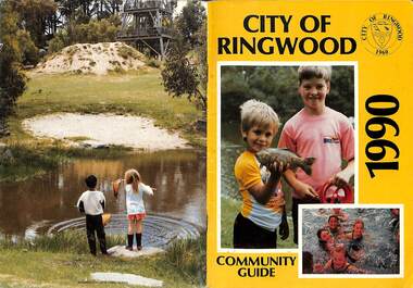
Booklet, City of Ringwood 1990 Community Guide, 1990
Community information booklet issued by City of Ringwood for 1990 - covering the facilities and activities of the Ringwood Council and other local organisations and associations.CONTENTS: (page no.) 1. COUNCIL SERVICES After School Programme 33 Aged Services 33, 34,35 Aquatic Centre 15,16,17 Aquatic Centre Bonus Vouchers 17 Biological Wasp Control 24 Budget 13,14 Building information 26 By-Laws 29 Chief Executive's Message 9 Children's Services 44 Citizenship 35 Civic Centre 4 Committees of Council 5 Common Questions 39 Council Meeting Dates 4 Council Representatives 8 Councillors 6,7 Dogs 29 Emergency Telephone Numbers 67 Family Day Care 32 Fire Hazards 29 Garbage 37 Golf Course 19 Health and Environmental Services 24 Home Handyman Services 54 Home Help 33 Immunisation 25 incinerators 29 Knaith Road Child Care Centre 32 Library 22 Library Service Senior Citizens 34 Maternal and Child Health 31 Mayoral Message - Cr. Lillian Rosewarne 3 Meals on Wheels 33 Members of Parliament 40 Parks and Gardens 22,23 Rates 28 Residential Development Provisions 12 Ringwood Bypass Road 11 Ringwood Convention Centre & Performing Arts Centre 20 Ringwood District Centre 13 Ringwood Festival 21 Shopping Bus 34 Staff 10 Town Planning 26 Works Depot 36 Youth Outreach Worker 36 2. LOCAL COMMUNITY SERVICES Accommodation 42 Aged Accommodation 42 Alcoholism 42 Arthritis Foundation 43 Arts and Crafts 43 Blind 43 Care Force 43 Catholic Family Welfare Bureau 43 Central Ringwood Community Centre 43 Childbirth and Parenting Association 44 Churches 45 Community Services Victoria 47 Day Centres and Drop-in Centres 48 Disabled Facilities 49 Do Care 50 Drugs 50 Elderly Day Care 50 Emergency Housing 51 Family Planning Services 51 Financial Counselling 52 Hearing Aid Service 53 Hospitals 54 Housing 54 Information 55 Legal 55 Literacy 55 Lone Parents 57 Marriage Celebrants 57 Maroondah Social Health Centre 57 Neighbourhood Mediation Centre - Outer East 57 North Ringwood Community House 53 Nursing 59 Optometric Services 59 Playgroups 60 Pre-Schools 60 Red Cross 61 Retirement 62 Ringwood Croydon Advisory Service 62 Schools 63 Senior Citizens' Centres 65 Transport 66 Twins 66 Unemployment 66 Volunteering 66 Youth Accommodation Project (Maroondah) 67 Youth Emergency Services 67 rinx -
 Ringwood and District Historical Society
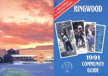
Booklet, City of Ringwood 1991 Community Guide, 1991
Community information booklet issued by City of Ringwood for 1991 - covering the facilities and activities of the Ringwood Council and other local organisations and associations. Includes 2 free passes to Ringwood Aquatic Centre.CONTENTS: (page no.) After School Programme 20 Aged Services 17 Aquatic Centre 12 Aquatic Centre Bonus Vouchers 14 Biological Wasp Control 35 Budget 10 Building Information 28 By-Laws 25 Chief Executive's Message 8 Children's Services 20 Citizenship 24 Civic Centre (i) Committees of Council 6 Common Questions 39 Council Meeting Dates 6 Council Representatives 7 Councillors 4 Dogs 25 Emergency Telephone Numbers 67 Family Day Care 44 Fire Hazards 31 Garbage 32 Golf Course 14 Health and Environmental Services 35 Home Help 52 Home Maintenance Services 17 Incinerators 31 Knaith Road Child Care Centre 21 Library 24 Library Services Senior Citizens 18 Maternal and Child Health 21 Mayoral Message – Cr. Betty Milton 1 Meals on Wheels 17 Members of Parliament 40 Parks and Gardens 26 Rates 10 Ringwood Convention Centre & Performing Arts Centre 15 Ringwood District Centre 10 Ringwood Festival 23 Shopping Bus 48 Town Planning 27 Works Depot 29 Youth Worker 19 rinx -
 Ringwood and District Historical Society
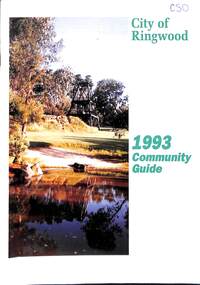
Book, City of Ringwood, City of Ringwood 1993 Community Guide, 1993
Community information book issued by City of Ringwood for 1993 - covering the facilities and activities of the Ringwood Council and other local organisations and associations. Includes two Ringwood Aquatic Centre bonus entry vouchers valid until June 30th, 1993. Cover photographs: Front - Poppet Head, Ringwood Lake; Back - Opening of North Ringwood Child Care Centre. CONTENTS: (page no.) Message from the Mayor – Cr. Greg Adkins, J.P. 3 Councillors 4 Council & Committee Cycle 5 Council Elections 6 History of Ringwood 7 Chief Executive's Report 8 The Management Team 9 Functional Responsibilities 10 Community Liaison 11 Council Expenditure for 1992/93 12 Rates and Valuations 13 COUNCIL SERVICES Community Services 14 Protecting the Environment 17 Protecting Our Community 19 Town Planning 21 Building 22 Design and Investigation 23 Works 24 Street Index - Electoral Wards 25 Neighbourhood Map 26 and 27 COUNCIL RECREAION AND LEISURE FACILITIES Ringwood Golf Course 29 Aquatic Centre 30 The Ringwood Convention Centre 32 Ringwood Library 34 Ringwood Recreation 35 Parks and Reserves 30 Community Directory 38-50 Community Information Data Bank 51 Aquatic Centre Vouchers 51rinx -
 Ringwood and District Historical Society
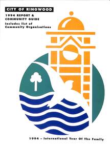
Book, City of Ringwood, City of Ringwood 1994 Report & Community Guide, 1994
The City of Ringwood and the City of Croydon merged in December 1994 and became the City of Maroondah.Community information book issued by City of Ringwood for 1994 - covering the facilities and activities of the Ringwood Council and other local organisations and associations. Includes Ringwood Public Golf Course discount vouchers and two Ringwood Aquatic Centre bonus entry vouchers.CONTENTS: (page no.) Contents A Message from the Mayor - Cr. Margaret Cheevers 3 Your Council 4 Local State and Federal MPs 5 Council Meetings and Elections 6 History of Ringwood 7 City Manager's Report 8 Organisational structure 9 Human Services 10-19 Environmental Health 20-21 Ringwood Library 22 Parks and Gardens 23 Ringwood's Parks and Reserves 24 Building 25 Engineering Planning Services 26-28 Waste Management 29 Town Planning 30 Traffic and Local Laws 31-33 Roads, Drainage and Major Works 38-39 Halls and Facilities 40-41 Aquatic Centre 42 Convention Centre/Karralika Theatre 43 Golf Course 44 Free Swim & Golf Discount Vouchers 45 Community Organisations 46-64 Finance 65-66 Administration 67 Community Liaison 68 Information Systems 69 Personnel 70-71 Risk Management 71 Rates and Valuations 72 rinx -
 Ringwood and District Historical Society
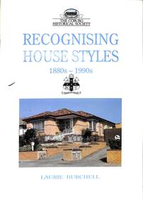
Book, Coburg Historical Society, Recognising House Styles 1880s-1990s - Laurie Burchell, 1991
Architectural references aimed at assisting researchers in describing, understanding, dting and comparing individual buildings in the Coburg area in Victoria.Foreword by Miles Lewis -
 Bendigo Military Museum
Pamphlet - SOUVENIR PROGRAM, SOLDIERS MEMORIAL INSTITUTE 2018, City of Greater Bendigo, C. Nov 2018
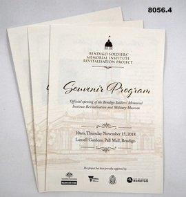
When the SMI was opened in Nov 1921 the Bendigo RSL Sub - Branch had occupancy from that day on. The Building became a Museum opened to the public in 1998 by the RSL. The origins of this project goes back to 2011 with a letter to the City of Greater Bendigo of the possibility of an upgrade to the SMI from the Bendigo District RSL Sub - Branch Inc. Some renovations had already taken place and some structural work. After initial talks a sub - committee of 3 persons from the RSL was elected to work with the Council along with other bodies who would be involved. Plans eventuated by 2015 and were put to the RSL for approval. From there the fund raising began from the State/Federal Govt's, RSL, the Public and Council itself. This was achieved and finally in Sept 2016 the SMI/Museum was packed up completely and the Renovations began in 2017. Souvenir program, card yellow colour folding, front page is in gold and black writing with an image of the Dome on the SMI followed by in gold, "Bendigo Soldiers Memorial Institute Revitalisation Project" then in gold, "Souvenir Program", in the centre has details re time, date, place. At the bottom are the logo's of the Federal & State Governments, RSL and City of Greater Bendigo Page 2 is titled "About the Bendigo Soldiers Memorial Institute" with a photo showing the "Hustlers Royal Reserve Mine No 2" which was on the site where the SMI now stands. Page 3 has details of the program, music, Official welcome, speakers, ribbon cutting, the ODE, Last Post, National Anthem, close of formalities and light refreshments. Page 4 has a photo of the original souvenir pamphlet used at the original opening on November 15th 1921, 97 years to the day. at the bottom, "Thankyou section to all those involved in the project""Official opening of the Bendigo Soldiers Memorial Institute Revitalisation and Military Museum 10am Thursday November 15, 2018, Lansell gardens, Pall, Mall Bendigo"brsl, smirsl, program -
 Warrnambool and District Historical Society Inc.
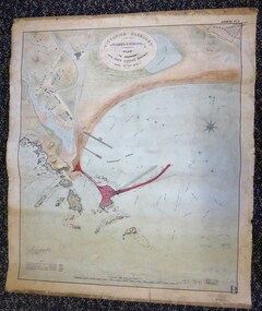
Map - Warrnambool Port 1879, 1879
The port facilities in Warrnambool Bay were in constant use from the first years of Warrnambool’s settlement but there were also difficulties for the shipping trade – a small and unsafe anchorage, the lack of loading facilities and little natural protection from the southerly gales. From the 1870s on there was local agitation for some sort of Breakwater to be built and an Andrew Kerr design was approved by the Warrnambool Council but no funds were made available from the Victorian Government. Throughout the 1870s the building of a Breakwater was a major political issue in the district with preliminary work being funded and started in 1874. In 1879 the Government agreed to a further inspection of the area and an official report. Sir John Coode (1816-1892) was commissioned to make this report. He had come to Australia in 1872 to advise on harbour construction. Coode recommended a 1800 feet long Breakwater and wharf connected to the shore and it was this proposal that the plan described herein and drawn up in 1879 was to accompany. The original plan was eventually modified because of the cost and a Breakwater was completed in 1890 under the direction of the engineer, Arthur Dudley Dobson, with extensions early in the 20th century. This plan is of great interest as it shows in simple graphic form the original plans proposed by Sir John Coode for the Warrnambool Breakwater. It is therefore of great historical importance. The Breakwater was not the maritime success that it was hoped it would be but it is today a significant feature of our foreshore. This is a Plan drawn up in 1879 by Victorian Harbours to accompany Sir John Coode’s Report on the proposed Warrnambool Breakwater. The chart detail is hand-drawn and hand-tinted on canvas with the names of places, geographical and marine features and local points of interest added in print. The edges of the chart are rubbed and the chart is somewhat faded and dirty but the main colours of red, green and brown are still clearly discernible. The title of the plan is printed in an oval inset at the top of the chart. The plan shows two possible Breakwater designs, one from the Borough Surveyor (Andrew Kerr?) and one from Sir John Coode.Victorian Harbours Warrnambool Plan to accompany Sir John Coode’s report Dated 28th Feby 1879 warrnambool breakwater, andrew kerr, sir john coode, arthur dudley dobson, warrnambool, warrnambool harbour, warrnambool history, warrnambool beach -
 Warrnambool and District Historical Society Inc.
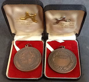
Medal - Warrnambool City Council Citizenship Award -Cyril Hayward, Mid 20th century
Cyril Hayward came with his wife Joyce to Warrnambool from England in 1955. For 30 years he and his wife were dominant figures in the performing arts organizations in Warrnambool. Cyril Hayward was a leading figure in the Warrnambool Theatre Company as an actor, stage manager, electrician, technician and the person who did any other job that needed to be done. He was a Life Member of the Theatre Company and President of the Warrnambool branch of the Victorian Arts Council, organizer of the weekly talking newspaper for the visually impaired, a tutor for the local Adult Literacy Scheme, a founding member of the Warrnambool Probus Club and was on the building committee for the development and building of the Performing Arts Centre in Warrnambool. The Warrnambool City Council gives Citizenship Awards annually.This is a significant item because it was an award received by Cyril Hayward, a prominent person in the Warrnambool Arts scene for 30 years.This is a bronze-coloured medallion presented to Cyril Hayward as a citizenship award in 1982. It is circular in shape with the crest of the City of Warrnambool on one side and a laurel wreath with inscriptions on the other. It has a ring at the top for hanging the item. It is in a black leather box lined with red velvet and white silk and includes a small metal stand to display the medallion. Medallion – City of Warrnambool, Dieu et Mon Droit, By These We Flourish Citizenship Award, Cyril Hayward, 1982, Stokes Melb. Box – Stokes(A/Asia) Limited, Melbourne, Australia, estd. 1856 cyril hayward, warrnambool city council -
 Warrnambool and District Historical Society Inc.
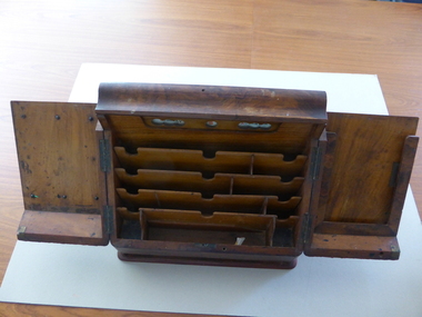
Desk, Writing desk, Mid 19th century
This writing desk was used by the Warrnambool Bank of Australasia personnel and the date associated with it (through unproven Historical Society records) is 1859. The Bank of Australasia was established in Sydney in 1835. The Warrnambool branch of the Bank of Australasia was established in 1854 in a stone cottage in Merri Street leased for two years. The bank was next located in a leased building in Timor Street with new purpose-built premises at the corner of Timor and Kepler Streets opening in 1860. In 1951 the Bank of Australasia merged with the Union Bank to form the A.N.Z. Bank Limited. In 1970 the E. S. & A. Bank and the London Bank of Australia merged with the A.N.Z. Bank forming the A.N.Z. Banking Group Limited with the business transferring to Liebig Street. The old Bank of Australasia building was purchased by the Warrnambool City Council and later sold to a private buyer. It is now a nightclub. The writing desk may have been used in both the Timor Street leased building and the bank building at the corner of Kepler and Timor Streets. William Palmer was the Bank Manager when the desk would have been first used. This is a most significant item as it comes from the Warrnambool Bank of Australasia, the first bank to be established in Warrnambool and a major banking business in Warrnambool for nearly 100 years. The desk was handed over to the Warrnambool and District Historical Society by Clarrie Kempton, the A.N.Z. Bank Manager in Warrnambool from 1964 to 1971.This is a wooden writing desk, possibly made of walnut wood. The base is rectangular with a drawer with a brass handle at the base. From the base the desk slopes up to a triangular shape with a slightly curved top. The middle of the desk has a front opening with two doors with four brass hinges with a brass lock. There are six bolts, one with a slot missing. Inside the doors are inset 10 wooden slots of different sizes to hold papers, letters, ink, dockets etc. Also inside the doors, behind a transparent material, are spaces for the day, date and month. These numbers and letters were once able to be changed according to the date. The writing desk is in good condition but a little stained. ‘Tuesday’ ‘8’ ‘November’ bank of australasia, history of warrnambool, history of warrnambool -
 Warrnambool and District Historical Society Inc.
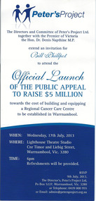
Document, Invitation Peters Project, 2013
Peter’s Project is an organization set up to raise funds for a Regional Cancer Care Centre in Warrnambool and to manage the Centre after it is built. The project was initially set up by Vicki Jellie in memory of her husband, Peter, who died of cancer some years earlier. The main aim was to build a centre for the treatment of cancer in Warrnambool so that many cancer sufferers did not have to go to Geelong or Melbourne for treatment. Government and local Council funds have been obtained for the project with the general public contributing to an appeal to raise $5 million. This target has been reached. The building is currently being erected. This invitation to the Official Launch of the appeal was sent to Bill Phillpot who was the Director of the appeal. This invitation is of some interest as it indicates the launch of the public appeal for funds for Peter’s Project and it is a great example of one person commencing a community campaign which was very successful and will have far-reaching results. This is a single-sheet card sent to Bill Phillpot by the Directors and Committee of Peter’s Project Ltd and the Premier of Victoria, Dr Denis Napthine. It is an invitation to attend the launch of the public appeal towards the building of a Cancer Care Centre. The card has blue printed material on a white background with the logo of Peter’s Project at the top left hand corner.peter’s project, warrnambool regional cancer care centre -
 Warrnambool and District Historical Society Inc.
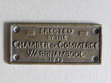
Brass Plate, Chamber of Commerce 1933, 1933
This plaque has been attached to a Warrnambool installation in 1933. It is not known to which site this refers but it may have been the Warrnambool Information Pavilion which was erected outside the old Warrnambool City Council Chambers. There have been many Warrnambool Chambers of Commerce over the years. These were established by Warrnambool businessmen and women to promote the interests of the town/city and to encourage the development of local industry and the tourism trade. This plaque is of great local interest but unfortunately does not have a clear provenance.This is a small brass plaque. The plaque has four holes at each corner for attachment to a building or other object. ‘Erected by the Chamber of Commerce, Warrnambool, 1933’warrnambool chamber of commerce, warrnambool city council chambers, plaque -
 Kiewa Valley Historical Society
Report - Alpine Study Area Volume 2 Maps, Land Conservation Council, 1970s
The Victorian Environmental Assessment Council and the former Environment Conservation Council (ECC) and Land Conservation Council (LCC) have completed 36 land use investigations over more than 35 years, including 27 regional reviews. They provide a framework for use of Public Land in Victoria. The Land Conservation Council was established by the Land Conservation Act 1970.These maps provide an assessment of the Alpine area at the time the maps were created. Some of the topics eg. Rainfall and water resources may change over the years thus providing a comparative analysis. Others may provide information for future development such as mineral exploration, building of a dam / tunnel etc.Blue box shaped folder containing 9 of 10 Maps of the Alpine Study Area produced by the Land Conservation Council. Maps include 1. Public land and descriptive blocks. 2. Physiography. 3. Topography. 4. Geology (missing). 5. Rainfall and water resources. 6. Vegetation 7. Land systems. 8. Recreation. 9. Primary production. 10. Minerals Ex library item. Stamped in red "Discarded From Stock / Swan Hill Regional Libraryalpine area, maps of alpine area, land conservation council -
 Warrnambool and District Historical Society Inc.
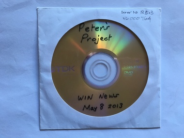
Audio Visual, Audio Visual - DVD (Peter’s Project)
Peter’s Project is an organization set up to raise funds for a Regional Cancer Care Centre in Warrnambool. The project was initially set up by Vicki Jellie in memory of her husband, Peter, who died of cancer some years earlier. The main aim was to build a centre for the treatment of cancer in Warrnambool so that many cancer sufferers did not have to go to Geelong or Melbourne for treatment. Government and local Council funds have been obtained for the project with the general public contributing to an appeal for $5 million. This target has been reached and the building is currently being erected. This DVD is of a May 2013 Win TV telecast of interviews and information regarding the public appeal.This DVD is of some interest as it indicates the results of one person’s campaign and the community’s response. The campaign has been very successful and will have far-reaching results. This is a plastic DVD, yellow-coloured on one side and silver on the other. It is in a white envelope with a clear plastic window. In biro – ‘Peter’s Project, Win News, May 8, 2013’ Printed on disc – TDK, Life on Record, DVD-R 1-16 x Speed, 14.7GB, DVD’ peter’s project, warrnambool regional cancer care centre -
 Warrnambool and District Historical Society Inc.
Map, Plans (5) showing Subdivisions of Warrnambool, 1989
These plans have been drawn by Steve Hester for the Warrnambool City Council to illustrate the allotments in Warrnambool concerned with the subdivisions of 1989. The streets have not been named but there is an indication of the area with the identification of known buildings (eg Hospital) and the plan numbers of each allotment is clearly marked. These numbers corresponded to the plan numbers registered in card files and ledgers in the Warrnambool City Council offices. The scale of the plans was 1 to 5000. These plans are of considerable interest because they show Warrnambool street subdivisions of 1989 in illustrative form. They show how information was collated in the late 1980s before the widespread use of computer digital means to describe and store information.These are five hand-drawn sheets showing plans of sub-divisions in Warrnambool streets in 1989 (Warrnambool City Council material). The plans are multi-coloured (crayons) and show allotments with plan numbers. The first plan has much of the material torn off but the location is known to be in the Russells Creek area. Some of the green tape around the edges is missing. Plans two to five are almost intact and are bound with green tape. Plan Two- Industrial Estate of West Warrnambool; Plan Three – Hospital/Merrivale/ Lake Pertobe areas; Plan Four – North Warrnambool, Wollaston/Brierly areas; Plan Five – Flaxman Street area. ‘Subdivision Plan, Reference Guide, Steve Hester, Oct. 1989’. warrnambool street subdivisions, steve hester, history -
 Warrnambool and District Historical Society Inc.
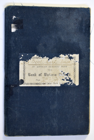
Financial record (Item) - Warrnambool Mechanics Institute & Free Library Bank of Victoria Bank Book, The Bank of Victoria Limited Warrnambool, 1904-1911
The Bank of Victoria was located at 7a Liebig Street, Warrnambool. The building still exists in 2023 as a part of the Quest apartments. The Warrnambool Mechanics' Institute was formed in 1859 and the first reading room opened in 1884. Responsibility for all activities of the Warrnambool Mechanics' Institute activities were formally handed over to the Warrnambool city Council on 27th July 1911. This Bank of Victoria Limited passbook documents credits and debits of the Warrnambool Mechanics' Institute & Free Library from December 1904 until 30th June 1911 just prior to the transfer to the Warrnambool City Council. This passbook is an example of how banking records were kept in the early 20th century. W'Bool. Mech. Inst. in Account with the Bank of Victoria Limited. Page 742 783warrnambool mechanics’ institute library, bank of victoria, warrnambool -
 Warrnambool and District Historical Society Inc.
Inventory of Old Museum, Gaspars Modern Print, 1972
This inventory of the contents of the old Museum in Warrnambool dates from the 1920s. A Mechanics Institute under the management of a local committee was established in Warrnambool in 1854 and a Mechanics Institute building was erected in Liebig Street in 1871 (site of present Municipal Library). Museum items and art works began to be collected and housed in the Mechanics Institute building at that time under the care of a committee member and local policeman, Joseph Archibald. This collection did not survive in any significant form after Archibald left the town but it was revived and vastly expanded when he retired and returned to Warrnambool in 1880. Archibald is regarded as the founder of the Museum which officially dates from 1883. In 1910 the Warrnambool Town Council took over the management of the Mechanics Institute, including the Museum collection. This museum continued until 1963 and was a much-loved institution in the city. The contents of the old Museum were dispersed, with many items lost but a considerable portion of the collection was under the care of Warrnambool Art Gallery and John Welsh, the Director in the 1970s, in an effort to keep the records of the old Museum intact, had the 1920s inventory reprinted. This inventory of Warrnambool’s old Museum is of considerable historical importance as it is an almost complete record of the Museum’s contents in the 1920s and so is very useful to researchers today.This is an inventory of 190 pages with a cardboard backing. The pages have three punched holes on the left side and are tied together with black and white cotton cord. At the front of the pages is a plastic envelope with a heading. The pages contain typed material, mostly in mauve ink and these are copies of the original typing. The typing on some pages is very faint and two pages have been re-copied to make them more legible. Warrnambool Art Gallery Old Records of the Warrnambool Museum collected by John A.Welsh, Director, and restored by Gaspars Modern Print 25th September 1972. old museum, mechanics institute building, history of warrnambool, joseph archibald -
 Warrnambool and District Historical Society Inc.
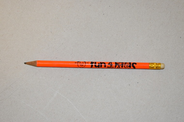
Pencil, Fun 4 Kids Festival, Early 21st century
This pencil is a souvenir of the Fun 4 Kids Festival, a children’s festival run by Warrnambool City Council from 1999 to 2018. It was held during a week in winter on the Civic Green at the corner of Timor and Liebig Streets with the site including temporary buildings as well as the adjoining permanent buildings. The festival was highly regarded and won the 2015 Gold Australian Tourism Award. Declining numbers and increasing costs led to its demise in 2018.This pencil is a memento of Fun 4 Kids, a children’s festival run by the Warrnambool City Council. Existing for 19 years, it was one of the longest surviving children’s festivals in Australia.This is a round wooden pencil containing a thin sliver of graphite. The pencil has a metal band and a rubber at one end and is sharpened at the other end. The pencil has an orange covering, black lettering and an image of a child and a sun.Fun 4 Kids Festivalfun 4 kids warrnambool -
 Port of Echuca
A coloured rectangular photograph, November 1979
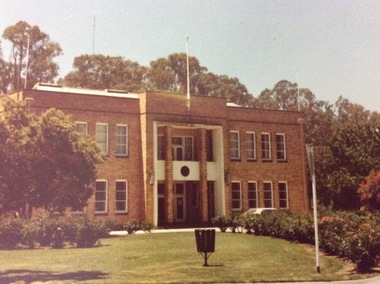
This photograph was taken from Hare Street and shows the City of Echuca council offices, before the Shire of Campaspe came about. As the Shire got bigger these offices were extended, and in 2010 the new Echuca Libray was built on the west side of this building.This photograph is significant because it shows the City of Echuca building at the end of the 1970's.A coloured rectangular photograph of the City of Echuca offices, taken in 1979 from Hare Street.Stamped in red on the back 'Print made by Kodak M Nov. 79. It's Kodak for Color.' In blue pen in the top left hand corner is an uppercase R. shire of campaspe, city of echuca, hare street, 1979 -
 Port of Echuca
Photograph - Black and white photograph, Late 1970s
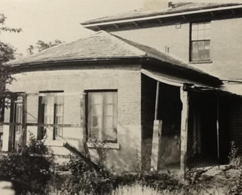
Relates to a series of 5 photos:P000094-P000098 of the front of the Bridge Hotel on the corner of Murray esplanade and Hopwood gardens. These photos, taken about 1976, were before the Port Restoration Scheme renovated the hotel. The Bridge Hotel was built by Henry Hopwood in 1858. This and the Bond Store were Echuca's first 2 brick buildings. Named from Hopwood's nearby pontoon bridge. The building was bought be The Council in 1970. Restored and reopened in 1975.The Bridge Hotel is an important part of Echuca's settlement and development. It was originally built by Henry Hopwood, the European founder of Echuca, in 1859. Hopwood built the hotel to provide accommodation to people using his punts across the Campaspe and Murray rivers that area central to the landscape of the Port. The hotel was situated on the land between both rivers and punts and provided for a variety of levels of accommodation from grand rooms to very basic rooms. At the time of the photos the hotel was 120 years old and became an important part of the Port of Echuca tourism. Black and white photograph of the Bridge Hotel , showing western wing before restoration.Stamped on the reverse "Gazemore Studio, D. G. Gay, 18 Frances Street Echuca 3625.bridge hotel, echcua, port restoration scheme, bridge hotel restoration, echuca -
 Warrnambool and District Historical Society Inc.
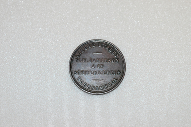
Coin - Token, W.W. Jamieson Store token
William Wilson Jamieson came to Warrnambool around 1857 after running a Ironmongers business in Hawthorne died . He opened his store in Liebig St which he operated until his death in 1882. He was quite active in the community serving on the town council for a number of years and also the Oddfellows Lodge and the Mechanics Institute. He came to Warrnambool in 1857, after running an Ironmonger's business in Hawthorn and having worked for the hardware company McEwan & Co. in Melbourne. He bought a weatherboard building that had previously been a 'bowling saloon' in Liebig Street and opened a business that Gardner describes as a general store and Turnbull describes as a drapery store. He was a member of the town council from 1862 to 1874 and from 1877 to 1880 and also served as mayor for two terms. He was also active in community organisations including the Mechanics institute and the Oddfellows This token is of great importance. It is significant for three reasons: 1. It is an example of an 1850s Australian token, demonstrating an early business practice in our history. 2. It is an example of a Warrnambool token produced by an important Warrnambool business (only two firms in Warrnambool produced tokens)A round copper token. The token was issued by: W.W. Jamieson & Co.. Liebeg St. Warrnambool, Storekeepers 1862 which is in raised lettering on the obverse of the token. The reverse features a blindfolded woman with the scales of Justice in her raised right hand. She is standing beside the seashore with a sailing ship in the background AUSTRALIA is stampedabove the figure anf the date 1862 is stamped below.W.W. JAMIESON & CO STOREKEEPERS LIEBEG STREET WARRNAMBOOL. AUSTRALIA1862jamieson token, warrnambool, william wilson jamieson, warrnambool ironmonger -
 Eltham District Historical Society Inc
Photograph, Fay Bridge, Warrandyte cool store, 9 September 2019
Remains of the old Warrandyte Dairy — Originally constructed to store milk for delivery from Mapleoak Dairies, delivered by the Bellinger family, up until the early 1970s. The Warrandyte Dairy closed in 1987 before the land and building was purchased by Melbourne Water in 1988 to reduce flood risk to the community and preserve riverside land from development on the site which sits on the Yarra River flood plain. In 2017, through a partnership with Manningham City Council, Warrandyte Historical Society and the Warrandyte Community Association, Melbourne Water renovated the 73-year-old site and installed interpretive signs detailing its history for the community.2019-09-09, fay bridge collection, warrandyte cool store, warrandyte dairy -
 Eltham District Historical Society Inc
Photograph, Fay Bridge, Old footbridge, 195 Laughing Waters Road, Eltham, n.d
This old footbidge is situated close to the shack that Gordon Ford built on the Yarra at Laughing Waters Road. Bernie Bragg also used to live there for a period of time. Gordon Ford and photographer Sue Winslow were married in 1965. They set up home in an old log cabin on the property Gordon had purchased in 1954 on Laughing Waters Road. Situated between the Yarra River and Overbank Road, Gordon had built a small mud-brick shack on the river and a pontoon. Over the decades the shack has been locally referred to as “the love shack”, the “rooting shack” or simply “Gordon’s shack”. Gordon and Sue commissioned local builder Graeme Rose to do a wattle and daub renovation and extension to the old log cabin on the north side of Laughing Waters Road. The work had only just been completed in 1965 when a bushfire swept through the area and destroyed the cabin. Gordon and Sue relocated to his property, Fulling, in Pitt Street, Eltham. In 1970 work started on a new house at the Laughing Waters property. Originally known as the Banana House, it is now known as Boomerang. Designed by Alistair Knox, the mud-brick house includes iron window grilles made by Matcham Skipper that puncture the curved mud walls. The grilles were made from ‘off-pressings’ from the Sidchrome tool works in Heidelberg. Gordon, Sue and family moved into the house in 1972. Their marriage fell apart and Sue moved to Sydney with the children around the same time Gordon commenced building Birrarung just below Boomerang on the Laughing Waters Road block. After the Fords moved out, Boomerang it was rented out to various share households of students, musicians, artists and environmentalists for twenty-four years. Gordon Ford sold Birrarung and Boomerang to Melbourne Water in 1999. The Laughing Waters Artist in Residence Program was developed as a partnership between Parks Victoria and Nillumbik Shire Council. Boomerang was deemed unfit for habitation so was used as a day studio only. By 2001 Boomerang was in a poor state of repair and by 2002 the last artist in residence was to use the house as a studio. Nillumbik Shire Council had been granted funds from the Melbourne Community Fund to restore both Boomerang and Birrarung but it was apparent in early 2003 that the funds would be insufficient to restore both houses. Boomerang was infested with termites which presented a risk to any occupants and so the decision was made to close Boomerang and concentrate funding on Birrarung. Boomerang was fenced off for safety and to prevent intrusion and remains ‘caged’ today (2023). However, it is readily apparent the property has been occupied by squatters over the years. By 2023 it was clear that the squatters had abandoned the property and sections of the roof structure have given away in some areas and collapsed internally. For a more in-depth description and history of the property and that of Gordon and Sue Ford, see Jane Woollard's book, "Laughing Waters Road; Art, Landscape & Memory in Eltham" published 2016.fay bridge collection, bernie's hut, birrarung, footbridge, gordon ford, gordon's shack, laughing waters road, love shack, yarra river -
 Eltham District Historical Society Inc
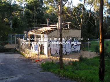
Film - Video (VHS), Jenni Mitchell, Demolition of the Shire of Eltham Offices, 1996
Poor video quality (noise and interference), edited raw footage with music and some commentary by Merv Hanna. A video documenting the demolition of the Shire of Eltham offices at 895 Main Road Eltham under the direction of the Commissioners appointed for the new Shire of Nillumbik and some of the communities activities surrounding the event. The building was demolished exactly 25 years after the southern wing housing Engineering and Planning on the upper level and the Eltham Library on the ground level was opened in celebration of the Shire of Eltham's centenary. Video has lots of distortion and noise, and sections of clips dubbed over. Immediate initial footage of Jenni Mitchell talking about asbestos claims in the Shire Offices (Sigmund Jorgensen standing behind her) advising Council did a review of the building several years previously and had been cleared of health problems. Cuts to group of people standing outside front door of offices but possibly voice dub over not related ? Then the date 27 Jul 1996 on a scene flashes on screen immediately followed by an edited clip intro of title and credits with classical music track. It then opens with Jenni Mitchell driving to the Shire Offices on Saturday 27 July 1996 at 11.00am. Footage of Main Road past Pitt Street, Alistair Knox Park then entering Shire Office driveway which is fenced off and contractor signs hanging up. Scenes at rear of building showing some internal demolition has commenced. View of the Administration wing. More clips of road driving, Alistair Knox Park, Eltham Library and visitor car park for Shire Offices. Cuts to a group of people standing in access to visitor carpark with new Eltham Library in background, one being immediate former Shire of Eltham President, John Graves. Scenes of people looking through chain link fence and security guard checking front door. John Graves being filmed that someone informed him the Shire was offering the building to the Community Health Centre for $2.3 million and that if they had been offered a price of $1.1 for what it apparently was sold for they would have snapped it up. View of truck loaded with brick rubble literally struggling to ascend the hill of Library Place to exit into Main Road. Cuts to a scene looking at Eltham War memorial Hall through the Memorial Gate, then the Shillinglaw trees and large banner sign ‘Delta Demolitions’ hanging on office façade. Views of front door, old library and bluestone wall. Scene (31 Jul 1996) filmed at night of several white crosses with “RIP Community” and “RIP Democracy”. Scene (1 August 1996) again driving along Main Road towards the Shire Offices then scenes of the offices showing substantially more demolition to exterior, groups of people standing on footpath outside watching, Delta heavy demolition machines, woman holding sign “Democracy where have you gone …”, the odd person in full protection gear and breathing apparatus hand carrying materials out to place on rubbish pile in front of people standing on footpath watching (with no protection) and then stamping on it to break it creating dust, security person in hard hat (no other protection) wandering around, many groups standing around watching, news film crew, person standing on roadside edge holding signs facing traffic stating “Pirate Planning” and “ Grant us your ears” also sign on back of parked car “Elthams High Jacks”, another sign “Community Democracy”, views of crosses in Main Road median strip “RIP Community”, groups of people on footpaths and reporters conducting interviews, footage of unknown person standing with Jenni Mitchell and Sigmund Jorgensen advising people have the right to protest, Jenni Mitchell urging people to ask questions of local MP and Council and Sigmund Jorgensen referring to the three historic Shillinglaw trees with demolition machinery operating in background, Jenni Mitchell and others installing more crosses in median strip; demolition machines operating inside and outside the building, more views of onlookers including Sigmund Jorgensen then Police approaching on footpath, workers and machinery continuing to operate, views of the old library being demolished, the former Community Services department, security personnel. Scene (2 August 1996) more heavy demolition machinery in operation smashing building up, people standing around southern wing watching, view overlooking Eltham Library of train pulling in to Eltham station. Scene (7 August 1996) more heavy demolition and people wandering around with only hard hat protection, no dust protection, comments from one operator dumping a bin of material stating “wait till there’s a Hungry Jack’s here, you’ll be laughing, fuel, videos, hamburgers. You’ll be up with the rest of the world soon, you’ll have electricity and everything here, ha ha ha ha”, more heavy machinery demolition and breaking up of materials, view of Hitachi train going by and Administration wing, view inside the front door opening of the staircase leading to upper level, person walking around operating heavy machinery with a hose spraying rubble (no protective gear other than hard hat interspersed with edit cuts of meeting of Commissioners and independent observers on panel as well as members of the community in public gallery. Nillumbik Shire CEO Barry Rochford addressing the meeting., Chief Commissioner Don Cordell directly addressing Jenni Mitchell with respect to permission to take photographs, Barry Rochford continues to address the question asked of Council about the valuation of the former Shire of Eltham Office building/site, public gallery calling out asking why was building demolished, what was the urgency. Scene (14 August 1996) views of southern wing, previous single demolition operator again mocking people filming, operators working in and around building, Shillinglaw trees and largely demolished front, heavy demolition equipment at work, piles of building rubble, hose spraying water over rubble, large trucks arriving for rubble removal and loading of truck. Scene (21 August) more of the same, building virtually down, Shillinglaw trees standing tall and alone, water spraying on rubble and wattle in bloom. Cuts to Council meeting with public onlookers. Barry Rochford walks out, Wayne Phillips addresses meeting explaining one or two people shouting, members of the community challenging Council (Commissioners) about why due process appear to have been subverted. Former Shire President Robert Marshall in public audience, cuts back to Shire office carpark entrance site and sign hung on fence in front of library “Think Again!” and people standing around observing awaiting a protest demonstration erecting a large sign on stilts stating “Shell No!”, people singing a revised version of God Save the Queen (God Save Us All), Sigmund Jorgensen in attendance, Jenni Mitchell, Sigmund Jorgenson and others address the protest crowd, followed by people mingling, music being played then people standing around the cleared site circumference all with arms linked (video very broken up with noise) then chants “Save the Gateway” and “No Shell for Eltham” and more music and singing “Put up a parking lot”. The crowd then proceeds to walk along the footpath of Main Road. Scene (15 Sep 1996) meeting at Montsalvat in Great Hall addressed by Sigmund Jorgensen discussing a recently published list of the Commissioner’s to senior Council Officers of banned Nillumbik people, others encouraging people to view proposed plans for the site and lodge objections. Specific issues regarding asbestos claims are also addressed. Harry Gilham addresses the meeting on the subject of the Eltham War Memorial and Memorial Gardens and how Council believe a roundabout in the vicinity is of greater importance. Views of various artworks on display (for auction) and music performance in the Barn Gallery. Meeting addressed by Sigmund Jorgensen discussing an appeal against Council granting a permit to Dallas Howgate to develop the site and that the Minister has called the matter in to be decided by the governing council. This is followed by an auction of paintings.Hi-Tech Ultra High Grade Video Cassette E-180 VHS dubbing of (poor quality) edited raw footage with some music from Star Wars and commentary by Merv Hannan Converted to MP4 file format 0:30:26, 2.6GBOn label " Merv's Demolition tape No. 2 Copy"video recording, 895 main road, alistair knox park, artworks, auction, barn gallery, barry rochford, community health centre, dallas howgate, delta demolitions, demolition, don cordell, eltham, eltham library, eltham shire office, eltham war memorial, eltham war memorial gate, eltham war memorial hall, great hall, harry gilham, jenni mitchell, john graves, library place, main road, memorial gardens, mervyn hannan, montsalvat, pitt street, protest, robert marshall, roundabout, shell oil, shillinglaw trees, sigmund jorgensen, sign, wayne phillips -
 Eltham District Historical Society Inc
Film - Video (DVD), Nillumbik Shire Council, Edendale Farm Community Environment Centre: History, c.2009
EDENDALE FARM Edendale Farm is Nillumbik Shire Council's environment centre situated in Gastons Road, Eltham between the railway and the Diamond Creek. The homestead on the property was built in 1896 and is of historical significance, being the subject of a Heritage Overlay under the Nillumbik Planning Scheme. The Edendale property was originally part of an extensive land purchase in 1852 from the Crown by pioneer Eltham farmer Henry Stooke. He initially purchased 51 acres and later expanded his holdings by purchasing another three adjacent Crown allotments extending northerly from Josiah Holloway's Little Eltham subdivision. Despite clearing the land, Stooke did not build on this property, choosing to live on his property "Rosehill" at Lower Plenty. In 1896 Thomas Cool, Club Manager of the Victoria Coffee Palace in Melbourne purchased 7 acres of the original Stooke land and built the house now known as Edendale. Cool did not farm the land, instead using it as a gentleman’s residence, retiring to Eltham at weekends. In 1918 he purchased an additional 7 acres but in 1919 he sold the property. Later owners included J.W. Cox, the Gaston family and D. Mummery. In the 1980s the Eltham Shire Council purchased the site for use as a Council depot, but this use did not proceed. Subsequently, it was used as the Council pound. The Edendale Farm Pet Education and Retention Centre was established in the summer of 1988/1989 and was set up to replace the existing dog kennels with a high standard pet retention centre. The design style of the building was established to compliment the features of the existing house. It was equipped with 10 retention pens, a veterinary room and a pet education area where school children and other interested parties learnt about pet care procedures. It was later developed into a community farm and was run by an advisory committee and in 2000 it became an Environment Centre. In early 2006 an advisory committee was established for the development of a master plan for future development at Edendale Farm. The committee included Russell Yeoman, a former long-time shire planner and founding member of the Eltham District Historical Society. At the time of filming the Master Plan and future for Edendale was about continuing to develop Edendale as a centre of environment learning and looking at expanding displays and school program, running a lot more of life-long learning and workshops around sustainable living.edendale community farm, eltham, gastons homestead, gastons road, shire of nillumbik, video recording -
 Eltham District Historical Society Inc
Photograph - Digital Photograph, Alan King, Former Police Residence, 728 Main Road, Eltham, 28 December 2007
The institutions of law and order in Colonial Victoria included the police, courts and prisons. The 1852 report of the Snodgrass Select Committee appointed to "identify the policing needs of the colony” noted there existed seven independent police forces that did not co-operate or regularly communicate. Following the committee's report all these police entities were merged into the Victoria Police, founded on 8 January 1853, to implement law and order responsibilities throughout the Colony of Victoria. The Eltham Courthouse (1860) and adjacent Police Residence (1859) formed a justice precinct established in the immediate aftermath of the 1852 police inquiry and the effects of the gold rush. The physical presence of these buildings, in the centre of the early Eltham township, defined centralised control over law and order. In the early days the Police Constable in charge would conduct his duties travelling around the district by horse; a stable was located at the rear of the residence. At times the horse would be grazed on the paddocks across the road. Horseshoes were forged by the blacksmith beside the Courthouse on the high side of “Policeman’s Hill”. Along with the stable, there was a two-cell bluestone lockup where prisoners were held awaiting trial in the adjacent Courthouse. Their meals were usually provided by the policeman’s wife or from the hotel just up the road. With the arrival of the railway in 1902 the town centre gradually shifted towards the railway station. The Police Station and operations were moved into the town centre in 1961 to a renovated house in Pryor Street, which was later replaced by the current Police Station. From 1961-1981 the residence was occupied by the Vermin and Noxious Weeds Destruction Section of the Department of Crown Lands and Survey. Prior to August 1967 the former Police Station was dragged to the rear of Police Residence to make way for the construction of a driveway and access from Main Road. The building was placed on the site of a former Scullery and modified for Lands Department use. In 1981 the Shire of Eltham took over management of the former Police Residence in Eltham. It remained unoccupied for a period whilst its future was discussed in Council. It was then used for a community job creation scheme until 1985. In 1985 the Shire of Eltham Parks and Environment occupied the residence. Council improved the driveway but later added a second rear access from Brougham Street due to the dangerous nature of the Main Road entrance. Additionally, a rear toilet facility between the Police Residence and the relocated former Police Station, which was doubling up as a lunchroom. Council also commenced discussions to re-establish a replica Police Station. Around November 1986 the former Police Station was demolished; believed to have been suffering termite damage. About 1989, after some years of discussion, a replica Police Station was built, based on photographs, to act as a lunchroom and meeting room for the Parks and Environment staff and volunteers doing community service. In 1996 Eltham District Historical Society held discussions with Nillumbik Shire Council commissioners throughout the year regarding a home for the Society. A proposal was put forward by the Society in October to occupy the former Police Residence. In March 1997 Eltham District Historical Society gained access to former Police Residence and on July 12, 1998, moved into its Local History Centre. In July 2018, Eltham District Historical Society gained access to the replica Police Station (which had been used as a music library and storage for the Eltham Concert Band) for use as part of regular heritage tours for schools and community-based groups. Covered under Heritage Overlay, Nillumbik Planning Scheme. Published: Nillumbik Now and Then / Marguerite Marshall 2008; photographs Alan King with Marguerite Marshall.; p65This collection of almost 130 photos about places and people within the Shire of Nillumbik, an urban and rural municipality in Melbourne's north, contributes to an understanding of the history of the Shire. Published in 2008 immediately prior to the Black Saturday bushfires of February 7, 2009, it documents sites that were impacted, and in some cases destroyed by the fires. It includes photographs taken especially for the publication, creating a unique time capsule representing the Shire in the early 21st century. It remains the most recent comprehenesive publication devoted to the Shire's history connecting local residents to the past. nillumbik now and then (marshall-king) collection, eltham, main road, eltham district historical society, eltham justice precinct, little eltham, local history centre, police residence, police station -
 Eltham District Historical Society Inc
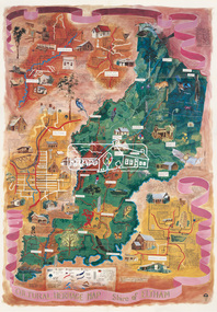
Map (item), Megan Evans, Cultural Heritage Map, Shire of Eltham, 1993
Copy of artist's map of the Shire of Eltham with numerous historical and cultural places of interest illustrated and notated including evidence of original Wurundjeri occupation and local flora and fauna. The original watercolour is held in the Nillumbik Shire Council Civic Collection. "Evans remembers being surprised they had asked an artist to create this map rather than a designer. Originally made as a watercolour, the map was later made into posters and adorned many homes around the area. The map creatively interprets the town and provides a wayfinding to both cultural and historical points in the area." Nillumbik Arts News December 2023. artist, buildings, cultural heritage map, fauna, flora, map, megan evans, shire of eltham, wurundjeri