Showing 1232 items matching "crown land"
-
 Federation University Historical Collection
Document, Zelda Martin, Central Victorian Goldmining towns - Boom Towns or Ghost Towns?, c1996
Zelda Martin was a PhD candidate at the University of Melbourne.[.1] 4th item in light blue display book titled Research Approach/Overview of Chapters/Confirmation of Canditure/Chapters1,2,3&4 of proposed thesis. *Twenty-seven page article on Victorian goldfields towns titled: Central Victorian Goldmining Towns - Boom Towns or Ghost Towns. The article was written during the author's PhD study. It outlines the context methodology, and resources and the chapters of the proposed thesis: (1) Central Victorian Goldmining Towns - The Context (2) Contemporary Views of the Factors Necessary for Town Growth (3) Outward Manifestations of Town Growth (4) The Trappings of Government (5-9) The Main Towns and Their Hinterland. [.2] 5th item in Light Blue display book as above item. *Chapter 1 of proposed thesis titled 'Pick, Shovel and Tin Dish Mining.' Covers in Section A: Central Victoria - Pre 1851: Aborigines in Central Victoria, Squatters, and Government. Section B: The years 1851-1854: The Early Gold Rushes, Government Reaction, Township Surveys, Legislation, Town Development, Local Government and Early Settlement. [.3] 6th item in Light Blue display book as above item. *2A of proposed thesis titled 'Contemporary Views of the Factors Necessary for Town Growth'. Similar information to Chapter 1 plus extra re towns and maps. Sections: Introduction, Context of Place - Geographical Towns Listed, The Context of Time - Pre1851 Aborigines, Governance of Port Phillip, The Squatters, The Villages of Central Victorian Highlands, Conclusion, Condensed Version of Chapter2B. [.4] 7th item in Light Blue display book as above item. *Chapter2B of proposed thesis. Sections: Area of Research, Schools, Banks, Newspapers, Progress Association, Town Development - Sandhurst (Bendigo), Ballarat, Castlemaine,, Maryborough, Ararat and Stawell. [.5] 8th item in Light Blue display book as above item. *Chapter 3 of proposed thesis titled 'Outward Manifestations of Town Growth'. Sections: Introduction, Contemporary Writing, Educationalists, The Bankers, The Townsfolk, Current Theory, General Theories of Urban Development, and Conclusion. [.6] 9th item in Light Blue display book as above item. *Chapter 4 of proposed thesis titled 'Trappings of Government' Sections: Introduction, Early Government Attitudes to Mining and Town Development, Law and Order, Township Surveys, Legislation, Local Government, Transport and Communication, The People and Lobbyists. [.7] 10th item in Light Blue display book as above item. *'The Rise and Fall of Central Victorian Goldmining Towns'. Includes a map showing main Goldfields, a table showing towns and villages at two points in time - 1857 and 1871; a Bibliography of Primary and Secondary Sources. [.8] Resource No1. Black display book titled Local Towns 1 : Alma: *Brief history *Directory *Maps Amphitheatre / Mountain Hut: *Brief History Post Office Directory Ararat: *Brief History *Post Office Directory 1869 - Alphabetical Listing by Occupation *Ararat - Prominent Citizens of 1858 *Langi-Morgala Museum Avoca: *Brief History *Excerpts from 'Avoca The Early Years', Margery and Betty Beavis; pg1 - Beginnings; pg11 - The Midas Touch; pg25 - Local Gold Escorts; pg27 - A Town is Born; pg51- The Administration of Justice; pg53 - The Ways of the Law; pg61 - News of the Day; pg65 - A Time to Play; pg72 - Land Ownership *Post Office Directory (Bailliere's) 1869 *Tourism Map and Information of area *Historic Avoca - A 5.5km Tour *Avoca & the Pyrenees Region - information pamphlet Ballarat: *Early History of Ballarat - Ballarat Historical Society, Publication No.1: origin of the name; Ballaarat - the Beginning; Fabulous Yields from the Ballaarat Goldfield; *Streetscape Lydiard Street. *Hand drawn map showing Leigh River, Old Portland Bay Road, plaque on road to Colac; etc. *Newspaper article re 'The Theatre Royal' ( which stood in the vicinity of the current Owen Williams store) - 'The News'15/04/1998 *Article - 'Ballarat's Mechanics' Institute Lives On' Ballarat Courier, 14/09/1985 *Article - Standing the Test of Time' The News 17/11/1993 re The Mechanics Institute & picture of the Reading Room *'Ballarat a Study of a City, Phyllis Reichl, pub. Nelson, 1968; no.3 place, time and people field studies series *Investigator Vol.33 No.2, 1998 Geelong Historical Society. Article on pg75 describes Ballarat in 1861 *Folded poster - 'Ballarat 100' a history of telegraph communication, pub. Telecom. Beaufort (Fiery Creek): *Brief history *Post Office Directory [.9] Resource No.2 Black Folder Titled Towns cont.No2 Bendigo (Sandhurst): *'Family & Local History at the Bendigo Library - 1851-2001 150 years of gold'. *Bendigo Government Camp in 1853 illustration; key to sketch and names of Government officers stationed there *Excerpts from 'Bendigo and Vicinity' Adolph Haman *The Bendigo Goldfield Registry - pgs 1-7 Introduction *Excerpt: 'Breaking the Grip' *Excerpt: The Most Go-Ahead Place *Excerpts from 'History of Bendigo' - anti license agitation; laying out of town; proposed railway; gold calls and dividends; the Sandhurst Municipality; journalism *Bibliography Blackwood: *Excerpts from 'Aspects of Early Blackwood - The Goldfield, the Landmarks, the Pioneers' Alan J Buckingham and Margaret F Hitchcock, JG Publishing,1980 Buninyong: *A Brief History *Investigator Vol1 No.2 Feb 1966 Geelong Historical Society. Pg3 - Article re gold escort route - Mt Alexander to Adelaide - (see a simple monument on the Western Highway a few miles out of Horsham. Pg 15 - Ballarat Excursion - re the finding of gold. *Three articles published by Buninyong and District Historical Society Inc: (Magpie Exploration; Finding Gold In The Green Hills; Magpie Exploration; Burnt Bridge to Cargarie to Mt Mercer) *Copies of newspaper articles/items *Buninyong Street Directory Carisbrook: *In the Beginning There Was Carisbrook *The History of the Carisbrook Racecourse Carngham / Snake Valley: *Brief History *Directory Castlemaine: *Directory 1865-1866 - Alphabetical and Street *Poster - Castlemaine A Contemporary Guide "The Great Centre" 1866 - A Contemporary Guide to the Fascinating Past *Pamphlet - Castlemaine District Community Hospital *Map - Castlemaine, Maldon & Surrounding Districts *Map and Information - The Dry Diggings Track - a 55kl walk among historic goldfields relics ( Castlemaine Fryerstown Vaughan Mt Franklin Hepburn Daylesford) *Postcard - Former Court House *Directory 1867 - Alphabetical, Trade [.10] Resource No.3 Grey folder Titled Towns 3 Creswick to Maryborough Creswick: *Brief History *Booklet - "Creswick Cemetery Walk" *Booklet - The Buried Rivers of Gold Heritage Trail Creswick *Creswick Historical Museum Information Sheet *Chronological History of Creswick *Alphabetical Directory of the Borough of Creswick *Creswick's Creek Directory 1856 *Historic Creswick Walking Tour *A Brief Account of the Schools of Creswick - Past and Present *100 Years of Railway Travel in Creswick *The Berry Deep Leads *The Spence Home at Jackass Gully in the Creswick State Forest ( William Guthrie Spence - Pioneer) *The New Australian Mine and the 1882 Disaster *Creswick District News, Issue 7, July August 1999 *The Creswick Miners Walk - Information and Map *Maps Chewton: *Brief History *Directory Clunes: *Brief History *Clunes Street Directory Daylesford: *Brief History *Notable Bushfires in Daylesford District Over More Than a Century - "Black Thursday" 1851; 1862; 1899; the Disastrous Hepburn Fire of 1906; 1939; 1944; 1969. *Post Office Directory -Daylesford and Hepburn Dunolly / Inkerman: *Brief History *Directory *Pamphlet - Goldfields Historical Museum *Pamphlet - Historic Dunolly - Victoria's Best Kept Secret *Map of Gold Workings at Dunolly Area - showing where the main gold rushes occurred *Brief History - Inglewood *Directory - Inglewood - Name Occupation, Dwelling Kingower: *Brief History *Directory - Name / Ocupation / Dwelling Linton / Happy Valley / Piggoreet: *Brief History *Directory - Lintons McIvor: *"A History of the Shire and the Township of Heathcote" by J.O. Randell Majorca: *Brief History *Official Post Office Directory 1869 - Name / Occupation/ Address Maldon (Tarrangower): *Brief History Part 1 *Brief History Part 2 *Post Office Directory *List - Alphabetical Order by Names plus Business and Trade (Tarrangower Times Oct/1858) *List - Alphabetical Order by Trade plus Name and Business *Directory - Name / Occupation / Dwelling Maryborough: *Worsley Cottage - built by Arthur Worsley, a contractor in stonework in 1894 [.11] Resource No. 4 Blue Display Book titled Towns 4 Moliagul to Stawell Moliagul: *Brief History *Moligul Legislative Assembly (Voting?) List - Names and Occupations *Moliagul Victorian Post Office Directory 1868 - Name / Ocupation / Address / Comments *"The Welcome Stranger" gold nugget *The Sunday School *The Welcome Stranger Discovery Walk - information and map Moonambel (Mountain Creek) Redbank *Brief History *List of names extracted from advertisments of the Pioneer and Mountain Creek Advertiser 16/02/1861. *Bailliere's Directory 1869 - Alphabetical List of Name / Occupation / Place St Arnaud: *Brief History Sebastapol: *Brief History *Directory 1869 - Alphabetical by Name; plus occupation and address. Browns and Scarsdale: *Brief History *Browns Street Directory - Name and Occupation Smythesdale: *Brief Description *Smythesdale Street Directory -Name and Occupation Stawell (Pleasant Creek) *Brief History *Victorian Official Post Office Directory - Name /Occupation / Dwelling *Chronology - 1841-1920 *Production of gold statistics - 1879 - 1900 *Big Hill *Extracts from "The Golden Years of Stawell". Chapt 1 - Stawell's Coming Out. Capt. 2 - The Gold Rush. Caapt.3 - Cradle of Democracy. Chapt.4 - The Reefs Becomes Stawell. Chapt. 5 - Rushing In. Chapt.6 - The Pioneers. Chapt 7 - The Decade of Optimism. [.12] Resource No. 5: Blue Display Book titled 'Towns Steiglitz to the The Golden Triangle. Steiglitz: Brief History Victorian Post Office Directory 1869 *Map of Steiglitz *List of maps relevant to Steiglitz history *Information 6 tables of data from "Reports of Mining Surveyors Talbot (Back Creek) Brief History Taradale: Post office Directory 1869 - Name/Occupation/Street. Also list in alphabetical order by Occupation Taradale *Chronological Reference to Taradale Mines *Water - The Coliban System of Waterworks *Joseph Brady *The Syphon Tarnagulla (Sandy Creek) *Brief History *Tarnagulla Businessmen Cameos to give depth to advertisments in 'The Tarnagulla Courier' various issues 1864-1871 *Directory - Name/Occupation /Address *List - Name/Business/Trade Wedderburn (Koorong) *Brief History *List - Name/Occupation The Golden Triangle: *The Early Rushes - Wedderburn / Moliagul / Sandy Creek - Tarnagulla / Jones Creek - Waanyarra / Kingower / Dunolly - Goldsborough / Inglweood *Census of 1857 - Population / Occupations *1858-1871 - A Time of Consolidation- Wedderburn / Moliagul / Sandy Creek- Tarnagulla / Arnold *Census 1871 - Population *Information gleaned from the census data - Demographics / Population / Occupations / marital / Birthplace / Religion / Literacy/ Occupation and Housing Cameos *Graphs - Birthplace of settlers /Male-Female Ratio / Married males / Children under 15 as Percentage of Population / Religion *Census 1857 - Statistical data *Maps *Bibliography [.13] Resource No. 6 - Black Display Book Information and Research in Central Victoria including: *Banking - Research from ANZ Bank Archives *Institutions - also includes articles listed from the Ballarat Times Newspaper *Australian mining History Association - A.M.H.A. Bibliography *Australia's Mining History * Bibliography - Land Surveys Victoria - *1853 Administration (Statistics and Other) includes: schools / ministers of religion / police / military / local administration / licences for sale of spirits / distances between various Victorian gold fields. * Victoria Government Gazette (Copy) - N0. 116, 12/12/1854 includes: Gold Felds Commission of Enquiry & No. 85, 15/09/1854 - Addresses presented to the Lieutenant Governor (Sir Charles Hotham) during his tour through the Gold Fields of Victoria,1854. Addresses on behalf of : the people of Bendigo; Members of the Church of England, Bendigo; Members of the Wesleyan Church on the Bendigo Gold Fields; Bendigo Gold District General Hospital; the Bendigo Prospecting Association; Committee of the Bendigo Local Exhibition; Bendigo District Medical Association; Coloured Americans Resident at Bendigo; German Inhabitants of Bendigo; Landowners, Inhabitants, and Miners of Castlemaine; Inhabitants of Forest Creek; Inhabitants of Heathcote and Gold Miners of McIvor; Residents and landholders of the District of Bacchus Marsh; Inhabitants of Kilmore and Vicinity. *Gold Fields Correspondence 1853: letter from Lieutenant Colonel Valiant, (Officer commanding the Troops in Victoria) to the Lieutenant Governor re threatened disturbance at Sandhurst (Bendigo) regarding the Gold License Fee. * Extracts from a book "Victoria" re Gold Fields Commission of Enquiry involving mainly Ballarat and Castlemaine and a chapter titled 'A Tour to the Victorian Gold-Fields' *Lists of central Victorian newspapers - listed by date published 1851to 1874; by first date available to State Library. *A list of cities and towns showing County, population in 1861 &1871, and municipal status. [.14] Resource no.7. Black display book. *Reference: Papers presented to Parliament Victoria - 1859-1860 4 volumes - relevant sections copied. Contains information on Branches of Government. General / Finance / Gold / Gazette / Commission and Warrant / Statistic. *Gold Fields Act. In accordance with the Act the gold fields are divided into six districts - Ballaarat, Castlemaine , Sandhurst, Avoca, Ararat, and Beechworth.. Official staff in each gold district consists of a Resident Warden, Wardens, Wardens' Clerks, Bailiffs, Chinese Protectors, Chinese Interpreters, and Mining Surveyors. *Gold Receiver *Gaols *Police magistrates and Clerks of Petty Sessions, etc. *Field Branch *Immigration and Emigration Overland - Chinese - 1859 *Population on the Goldfields *The Geological Survey - The Government Geologist is assisited by staff from four branches - the office Branch; the Publishing Branch; the Field Branch and the Museum Branch. *Commission to Enquire Into Sludge dated 10/02/1859 (Some sections copied) - Report to the Honorable Chief Commissioner of Public Works, Melbourne re the mode of carrying the sludge from the puddling mills in Sandhurst without interfering with the drainage of the town and the roads in the neighbourhood. [.15] Resource No.8: Camel display book titled Resource No. 8. Aborigines *Lists of book titles - +"Readings in Victorian prehistory" +"The Aborigines of Port Phillip" +Aboriginal languages and clans" +"A History of the Port Phillip District" +"Langi Ghiran 1: Aboriginal Rock...." +"Koorie History: sources for aboriginal studies in the State Library of Victoria", ed. Tom Griffiths, Melb. Friends of the State Library, 1989 +"The Public Lands of Australia Felix"; settlement and land appraisal in Victoria1834-91 with special reference to the Western Plains", J.M.Powell, Melb. Oxford University Press 1970 +*Bibliography of the Victorian Aborigines' from the earliest manuscripts to 31st December 1970, Massoa, Aldo, Melb. Hawthorn Press, 1971 +"Aborigines in Colonial Victoria, 1836-1886", M.F. Christie, Sydney University Press, 1979 +"Urban and Industrial Australia: readings in Human Geography" ed J.M. Powell, Melb. Sorrett Pub. 1974 *Extracts: -Processes of Pioneer Settlement - The Squatting Occupation of Victoria, 1834-60. J.M. Powell -Areal Variations in the Class Structure of the Central-Place Hierarchy. P. Scott - Volume1 and Volume 2: Notes Relating to the Habits of the Natives of Other Parts of Australia and Tasmania. Compiled from various sources for the Government of Victoria by R Brough Smyth. John Curry, O'Neil, Melb. 1st pub. Melb. 1876. p31-45 - Numbers and Distribution of the Aborigines in Victoria -Victorian Aborigines 1835-1901 - A Resource Guide to the Holdings of the Public Record Office, Victoria; published by the Government Information Centre 1984. *History of the Aboriginal Artefacts Displayed in the Daylesford Museum. F. G. Powell (4 page pamphlet) *Letter to Zelda Martin from Peter Lovett, Cultural Officer, Ballarat & District Aboriginal Co- Operative, 05/02/1997 *Map: Ian Clarke Victorian Tribunal Boundary Map - Clans of Central Victoria. *Victorian Rock Art and Mythology - Article about Mount Langhi Ghiran and myths of the Tjapwarong people. *Two Aboriginal myths relating to the Grampians - 'The Monster Emu' / 'The Aquisition of Fire', by the Aborigines in the Grampians Areas *Article titled (chapter 8) Ballarat - information re camping sites in the region. Lake Wendouree / Lake Burrumbeet (includes a myth) / Mt Bunninyong / Lal Lal / Pitfield / Mount Elephant / Mount Egerton / Meredith / Lake Goldsmith / Lake Learmonth / Ercildoune *Notes on the Aborigines of the Wider Ballarat Region plus European names=Aboriginal names. John Morris 26/07/1995 *Role of Aborigines in Town Development in Central Victoria. Mentions Native Police Force est. in Port Phillip 1842 and Central Board for Aborigines est. 1860 *The Grave of King Billy. (Frank Wilson) Pamphlet. *Camping Places in Central and Northern Victoria. Article re Lake Burrumbeet site. *Programme for the Unveiling of Memorial Cairn for Edward Stone Parker 1802-1865. Note portrait not accurate. Accurate portrait is available in the book "A Successful Failure A Trilogy The Aborigines and Early Settlers", Edgar Morrison, Graffiti Publications, 2002. * Large envelope addressed to Mr G Netherway containing newspaper cuttings regarding the life of Edward Stone Parker, the unveiling of the Memorial Cairn as mentioned above, articles titled 'Episodes from Our Early Days' (Edgar Morrison, Yandoit)- The Black's School, A School At Last and The Final years. Also a typed page titled 'Historical Background to E.S.Parker's Career. Includes an interesting tale titled 'When the cat lay doggo' re laying power leads for the unveiling ceremony at the memorial site. [.16] green display folder titled 'Research Aids' *List of references to Commissioners' & W'ardens' Reports (formerly held at La Trobe Library Archives, now at Public Records Office [PRO]). Indicates town referred to / date of report / name of camp if different to town. * Archive information re Anglican Records *Movement around the Goldfields - Miners and Storekeepers - usefulness of newspapers in providing information - areas covered - Castlemaine, Maldon, Ararat, Stawell, Tarnagulla, Dunolly. *Port Phillip /Victoria Directories 1839/1867 - Chronological list of Directories included in this series. *"Notes on the History of Local Government in Victoria" A.W. Greig Melb. University Press 1925 - Photo-copied extract p5-p40. (Source - Deakin University Library) - Introduction by W.Harrison Moore. Section 1 - Development in New South Wales Before Separation. Section 2 - Development in Victoria After Its Separation from New South Wales. Hand written notations: 'roads, markets, and local government 1855 on' ;'opportunity of squatters in parliament' and 'opportunities of matters in parliament p33' * Notes on the Establishment of Surveyor General's Department 1851and Commissioner of Crown Lands and Survey. * Newspaper articles from The Argus, 1849, re the discovery of gold in the Pyrenees region. * Excerpt - a report on schools - A.B.Orlebar, Inspector; re the need for permanent school buildings rather than tents. *Excerpt from - 'Approaches to Urban History', Sean Glynn: The Case for Caution * Except from - 'The Urban Sprinkle', Weston Bate: Country Towns and Australian Regional History *Reference- 'The History of Land Tenure in the Colony of Victoria', John Quick. References the Haines Land Bill, land tenure and Land Leagues. [.17] Light blue envelope folder titled 'Birtchnell's Ballarat, etc. Directory 1862 *Contains various directories for Smythesdale, Buninyong, Clunes, Brown's and Creswick. [.18] Red envelope folder no.2 titled Victorian Gazetteer *Selected pages from 1869 Victorian Gazetteer on A4 paper (with a handwritten note questioning if some pages are from 1868 Victorian Gazetteer as appears to be different sizes - A3 pages.) Information includes locations and descriptions of towns, hotels, banks, communications and populations. (Does not include names, residences and occupations) [.19] Red Envelope folder titled Bailliere's Official Post Office Directory 1868 (or1869 or a mixture of both?) *Preface *Contains a selection of pages of towns highlighted in yellow in the the index *Work on this directory was commenced in 1867. *Information includes: Municipalities - mayors and councilors; lists of towns naming male inhabitants and their occupations. [.20]Yellow manila folder titled Post Grad Seminar Presentation 1996 *Gives some background to Zelda Martin's proposed thesis and why she chose the topic Gold Mining Towns Boom or Bust [.21] A3 display book - No. 1A * A list of 'Relevant Newspapers collected: The Tarrangower Times and Maldon Advertiser (first published 1858) Includes dates 1858-1867. The Mount Alexander Mail. Includes dates 1854-1866 The Tarnagulla Courier. Includes dates from1864-1871 Dunolly and Burnt Creek Express. Includes dates from 1862-1871 * Selection of newspaper pages from The Mount Alexander Mail 1854 to 1856, mostly showing advertisements for businesses and services provided to that community. [.22] A3 display book - No. 1B * Selection of newspaper pages from The Mount Alexander Mail 1857 to 1866, mostly showing advertisements for businesses and services provided to that community. [.23] A3 display book -No. 2 * Selection of newspaper pages from The Tarnagulla Courier 1864 to 1871, mostly showing advertisements for businesses and services provided to that community. [.24] A3 display book - No. 3 *Selection of newspaper pages from The Tarrangower Times (and Maldon and Newstead) Advertiser 1858 to1867, mostly showing advertisements for businesses and services provided to that community. [.25] A3 display book - No.4 * Selection of newspaper pages from The Dunolly and Burnt Creek Express; and The Dunolly and Betbetshire Express 1862 to 1871, mostly showing advertisements for businesses and services provided for that community. [.26] A3 display book - No.5 Includes: * Bryce Ross's Diggings Directory. Includes instructions for using this directory. This directory was used by "all persons having connexion or desiring to communicate with 'working parties, private friends, or Stores at the Diggings." As a directory for each area wwas completed it was published in each month's issue of Bonwick's "Digger's Magazine." Years c1852/1853. This Directory commences first at the head of Forest Creek. Includes a directory for Bendigo and Ballarat. Of interest at the end of the Bendigo and Ballarat directory is a list of the number of storekeepers, butchers, doctors, smiths, eating houses, lemonade sellers and chapels. * The Castlemaine Directory and Book of General Information Comprehending Glass's Model Calendar for the Two Years 1862 and1863. "zelda martin, victorian goldfield towns, bendigo, castlemaine, ballarat, maldon, stawell, ararat, maryborough, creswick, avoca, heathcote, banks, bank of australasia, union bank of australia, government camp, sandhurst, water supply, tarnagulla, talbot, back creek, mountain creek, police court, carisbrook, dunolly, thompson's foundry, charles clacy, anthony trollope, robert cecil, mount alexander, urbanisation, national schools, education, govenrment, industry, railway, transport, settlement, land settlement in central victoria, steiglitz, joseph brady, the new australian mine, berry deep leads, william guthrie spence, creswick state forest, arthur worsley, worsley cottage, the welcome stranger, moliagul, moonambel, redbank, st arnaud, sebastapol, brown's, scarsdale, clunes, chewton, daylesford, bushfires, inkerman, inglewood, kingower, lintons, happy valley, piggoreet, mcivor, majorca, tarrangower, taradale, the coliban system, the syphon, sandy creek, wedderburn, koorong, arnold, jones creek, waanyarra, the golden triangle, census 1857, blackwood, buninyong, durham lead, magpie, carngham, snake valley, alma, amherst, daisy hill, amphitheatre, mountain hut, beaufort, fiery creek, counties, population, gold fields commission of enquiry1854, william westgarth, gold license fee, lieutenant colonel valiant, administration of the victorian gold fields, commission to enquire into sludge 1859, e.s. parker, edward stone parker, edgar morrison, mount franklin protectorate, dja dja wurrung, memorial cairn, franklinford, mt franklin memorial cairn, jajowurrong, dja dja wurung, tjaowarong, wothowurong, assistant protectors, daylesford museum, buluk, rock art - grampians, aboriginal mythology - grampians, aborigines, first nations people, mount franklin, aboriginal artifacts, lake burrumbeet, native police force, central board of aborigines, yandoit, commissioners' reports, wardens' reports, port phillip/victoria directories 1839-1867, local government - victoria 1853/1854, surveyor general's department - 1850's, victorian schools 1850's, a.b.orlebar, haines land bill, william charles haines, wilson gray, land tenure, land leagues, victorian gazetteer, the tarrangower times and maldon advertiser - 1858-1867, the mount alexander mail 1854-1866, the tarnagulla courier 1864, dunolly and burnt creek express 1862-1871, bryce rose's diggings directory, the castlemaine directory 1862-1863 -
 Federation University Historical Collection
Book, Robert S. Brain, Government Printer, Victorian Year Book 1895-8, 1901
... Australasian Colonies and other countries. Topics include the land... and other countries. Topics include the land system of Victoria ...This year book was published in the year of Australian Federation. It was the 22nd issue of the Victorian Year BookBrown soft covered book of 1000 page. The book contains a digest of the statistics of Victoria with reference to the other Australasian Colonies and other countries. Topics include the land system of Victoria, Crown lands, Agricultural statistics, cultivation, industry, livestock, wool, dairy farms, cattle, rabbits, manufactures, alcohol production, mining, defense. Statistics were provided by J.J. Fenton, Assistant Government Statist. -
 Federation University Historical Collection
Map, Smythesdale, County of Grenville, 1888, 1889
The map maker, Ferdinand M. Krause, was a professor at the Ballarat School of Mines. This land was printed form the Crown Lands Department, Melbourne. Coloured map of the County of Grenville. The edge has been taped. The scale is 40 chains to 1 inch. The map is accompanied with a foolscap sheet printed by the Mines Department in 1898. It is a Report on the Parish of Smythesdale by F.M. Krause and includes information on the water reserve, worked quartz veins, Watson's Hill, Surface Hill and Sugarloaf Hill, Haddon, Trunk Lead and the Crucible Shaft. smythesdale, krause, f.m. krause, ferdinand krause, nitingbool, watson's hill, surface hill, sugarloaf hill, haddon -
 Federation University Historical Collection
Certificate, Ballarat School of Mines Endowment Plantation, Nerrina Covenant, c1958, c1958
Throughout the Nerrina district numerous areas of public land were set aside as school endowment plantations as part of various schools’ educational resources. The plantations were initially established to instil through community involvement a love of forests and an appreciation of their value, and in fact many of them are well suited for regular use as a teaching resource of this nature. It was expected that this use will increase as courses embracing various aspects of environmental science are developed. Many school plantations have been planted to radiata pine, and revenue from the sale of produce used to provide amenities required by the schools. In some cases, however, these plantations have not been very successful in providing revenue, as the sites are unsuitable for economic growth or the plantations are too small or the location too far from processing centres to allow economic harvesting. In some instances, radiata pine plantations have failed due to poor management. In 1982 the Land Conservation Council believed that all the existing plantations should be assessed in order to establish their value as a teaching resource. Those not needed or that are unsuitable for teaching purposes for some reason, such as their location, should be terminated. Those planted to radiata pine that have limited value as a teaching resource although satisfactory for wood production may continue to be used for such production, but should be reviewed when the pines are harvested. (http://www.veac.vic.gov.au/reports/354-Ballarat-Study-Area.pdf, acccessed 30/03/2017) The School Endowment Plantation Scheme was established in 1922 as a joint venture between the Education Department and the FCV. It was administered by the Education Department with technical supervision by the Commission. While some plantations were established on private land donated or leased for the purpose, most were established on Crown Lands or Reserved Forest made available, without cost, by the State. (https://www.victoriasforestryheritage.org.au/community/schools.html, accessed 26 September 2020)Covenant in the matter of the School Endowment Plantation of the School of Mines Ballarat School Community.nerrina pine plantation, ballarat school of mines endowment plantation, nerrina, pine plantation, nerrina, john r. lyall, richard w. richards, dick richards, edgar j. tippett, charles h. clamp, alfred k. mcbain, endowment plantation -
 Federation University Historical Collection
Certificate, Ballarat Junior Technical School Old Boys Association Endowment Plantation, c1928, c1928
The School Endowment Plantation Scheme was established in 1922 as a joint venture between the Education Department and the FCV. It was administered by the Education Department with technical supervision by the Commission. While some plantations were established on private land donated or leased for the purpose, most were established on Crown Lands or Reserved Forest made available, without cost, by the State. (https://www.victoriasforestryheritage.org.au/community/schools.html, accessed 26 September 2020) Throughout the Nerrina district numerous areas of public land were set aside as school endowment plantations as part of various schools’ educational resources. The plantations were initially established to instil through community involvement a love of forests and an appreciation of their value, and in fact many of them are well suited for regular use as a teaching resource of this nature. It was expected that this use will increase as courses embracing various aspects of environmental science are developed. Many school plantations have been planted to radiata pine, and revenue from the sale of produce used to provide amenities required by the schools. In some cases, however, these plantations have not been very successful in providing revenue, as the sites are unsuitable for economic growth or the plantations are too small or the location too far from processing centres to allow economic harvesting. In some instances, radiata pine plantations have failed due to poor management. In 1982 the Land Conservation Council believed that all the existing plantations should be assessed in order to establish their value as a teaching resource. Those not needed or that are unsuitable for teaching purposes for some reason, such as their location, should be terminated. Those planted to radiata pine that have limited value as a teaching resource although satisfactory for wood production may continue to be used for such production, but should be reviewed when the pines are harvested. (http://www.veac.vic.gov.au/reports/354-Ballarat-Study-Area.pdf, acccessed 30/03/2017)Covenant in the matter of the School Endowment Plantation of the Ballarat Junior Technical School Old Boys Association Endowment Plantation.pine plantation, alfred k. mcbain, g.w.e. pearson, i.c. garner, a.m. robinson, h.j. hassell, ballarat junior technical school old boys association endowment plantation, ballarat junior technical school, alumni -
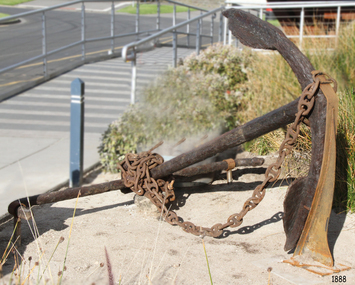 Flagstaff Hill Maritime Museum and Village
Anchor, Before 1831
Historical Information: The anchor is from the wooden sailing ship CHILDREN, which was wrecked at Childers Cove east of Warrnambool on the 15th of January 1839 with the loss of 16 lives. The Children anchor was raised from the wreck site by Flagstaff Hill Divers; Peter Ronald, Garry Hayden (Terang, still), Tim Goodall (now Warrnambool), and Colin Goodall (now Warrnambool), on Sunday 3rd January 1974. A week or so later it was dragged up the cliffs and taken to Warrnambool. It is now on display near the entrance to the Maritime Village and Museum. It appears to be a Pering’s Improved Anchor, developed at Portsmouth after 1813. The addition of broad curvature to the anchor arms provided a stronger purchase than the pre-existing Admiralty Old Pattern Long Shanked Anchor with straight arms. However, the evidence of hammer-welding the separate pieces of the arms and palms to the central shank (peaked crown and flat palms) suggests the manufacture is before the 1831 Rodger’s Anchor design, (which cast both arms and their flukes as one piece that was then attached to the shank by a bolt through the crown). This identification seems consistent with the date of the CHILDREN’s construction in 1824. The CHILDREN was a three masted barque with a wooden hull built at Liverpool in England. She was bought by the Henty family of Portland (Australia Felix) in 1837 for regular coastal trading between Van Diemens Land, the Port Phillip District of New South Wales and South Australia. Only 255 tons burden (92 feet in length, with a beam of 25 feet and depth of 17 feet), she sailed from Launceston bound for Adelaide in late December1838, on her first Australian voyage and under the English master who had brought her out – Captain H. Browne. On board the CHILDREN were 24 passengers, including 9 children; the captain and 14 crew; livestock of 1500 sheep, 8 bullocks and 7 horses; general cargo of beef, pork, tobacco, tripe, butter, limejuice, horse hair, currants, lead shot, beer and spirits; 5,000 house bricks from London; and six whaling boats with associated whaling gear. The vessel was battered by gale force north-westerly winds shortly after setting out from Launceston on 11 January 1839 and adverse sailing conditions persisted for the next four days. At 11 pm on the 15th of January 1839, and many miles north and east of the captain’s navigated position, the CHILDREN struck the Pinnacle, a limestone stack off Childers Cove. Within half an hour the ship was completely destroyed. As well as the loss of livestock and cargo, 16 passengers and crew perished, including the captain, six men, one woman and eight children. In 1931 shifting sands at Childers Cove uncovered the skeleton of an adult male. In 1951 another two skeletons were exposed by storms, an adult male and a child. In 1963 some district scuba divers retrieved a small signal-cannon from the site. And in 1974 Flagstaff Hill recovered the anchor and some house bricks. The shipwreck of the CHILDREN is of state significance – Victorian Heritage Register No. S116.A large forged-wrought iron anchor from the wreck of the CHILDREN. Flat hammer-welded flukes on opposing curved arms and a peaked crown. It has a metal (elbowed) stock or cross-bar and a heavy duty pinned shackle (not ring) for the anchor chain. It is in fair condition but extensively corroded after 135 years on seabed (supported on display) .warrnambool, shipwreck coast, flagstaff hill, shipwrecked coast, flagstaff hill maritime village, flagstaff hill maritime museum, shipwreck artefact, maritime museum, the children, childers cove, anchor, pering’s improved anchor, 1839 shipwreck. -
 Federation University Historical Collection
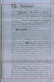
Document, Lease for the Former Ballarat Circuit Court House, Lydiard Street, Ballarat, 1870 and 1877, 05/1870; 1877
The Ballarat School of Mines opened in the former Ballarat Circuit Court House in 1870. The court house was demolished in 1915 to make way for the Ballarat Technical Art School. The Ballarat School of Mines is a predeccessor of Federation University Australia..1) Handwritten agreement on blue paper with green thread. The agreement is between the Board of Land and Works and Redmond Barry and others concerning a seven year lease of the former Ballarat Circuit Court House for use as a mining school (the Ballarat School of Mines). .2) Four lined fooscap pages relating to specifications of several works required to the Old Court House. .3) Rough notes on proposed lease of the Court House.lease, former ballerat circuit court house, redmond barry, legal, crown solicitor, gurner, robert davidson, warrington rogers, john warrington rogers, william warrington rogers, rivett henry bland, p. saunders, james williams, ballarat school of mines, ballarat school of mines establishment -
 Federation University Historical Collection
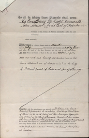
Documents, Appointment of New Trustees of the Ballarat School of Mines and Industries, 1894, 1894
A deed appointing the Reverend Samuel Thornton as a trustee of the Ballarat School of Mines, after the death of former Trustee Rivett Henry Bland, and increasing the number of trustees by appointing James Millhinch Bickett. It includes a covering letter of Department of Lands and Survey Letterhead... and whereas it is intended that forthwith after the execution hereof the said land and premises shall be so transferred that the same may become vested in the said Sir William John Clarke and John Warrington Rogers jointly with the said Right Reverend Samuel Thornton, Andrew Anderson and James Millhinch Bickett now these prexsents witness that the said Governor as such Governor as aforesaid in exercise of the power for this purpose given to him by the said Crown Grant and of every other power enabling him doth hereby appoint the Said Right Reverend Samuel Thornton to be a trustee of the land in place of the said Rivett Henry Bland and James Millhinch Bickett to the addition trustees. .. .department of lands and survey, letterhead, legal, john adrian louis earl of hopetoun, william john clarke, rivett henry bland, john warrington rogers, trustees, ballarat school of mines, ballarat school of mines trustees -
 Federation University Historical Collection
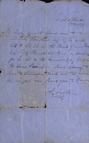
Document, Archibald Fisken, Bill of Sale, 1855, 28/09/1855
Hand written bill of sale between A. Fisken and John [Bonshaw?]Lal Lal September 28th 1855 I hereby agre to hand over to Mr John Bonshaw my right and title to lot 33 in the parish of Kirit Berrit and Fifty Pounds Sterling in Exchange for his lot on the Moorabool [?], lot 3 in the same Parrish. Each agreeing to trade & transfer made out, as soon as we get our grants from the Crown. A. Fisken. archibald fisken, john foushaw, bill of sale, land transfer, squatter, john bonshaw -
Federation University Historical Collection
Document, Crown Lands in Villiers and Westward Counties, 1856-7, 1856-7
Blue foolscap printed Government document lon Crown lands in Villiers and Westward Counties. It inlcudes the return shoiung number of acres of land sold and the amount received for same. land, land sales, villiers, heytesbury, hampden, normanby, dundas, follett, crown lands -
 Ringwood and District Historical Society
Document - Handwritten extract, Certificate of Title - LP7703 Mary Ann Williams, Bedford Road Ringwood, County of Mornington dated 18/4/1912
Two pages of notes and subdivision sketches on tracing paper.Mary Ann Williams of Bedford Road Ringwood in the County of Mornington, wife of John Williams of the same place, Gardener, is now the proprietor of and estate in fee simple subject to the encumbrances notified herunder in all that piece of land deliniated and coloured red on the map in the margin, containing 72 acres 3 roods and 30 perches of thereabouts being parts of Crown Portion 16, Parish of Ringwood, County of Mornington, together with a right of carriage way over the road coloured brown on the said map. 18/4/1912. Encumbrances - special railway conditions contained in Crown Grant to Nelson Polak. Transfer to Elizabeth Anne Yelland 10/9/1918 Transfer to Mary M Savage 16/5/1912 (?) Easement - Emma Blood 8/10/1919 (?) Turner - 12/3/1924 18 Greenwood Avenue 3/7/1915 Caveat no.63960 25/8/1924 -
 Ringwood and District Historical Society
Map, Plan of Subdivision Parish of Ringwood, Victoria - c.1960
Black and white photocopied plan - Part of Crown Allotments 14A and 40A showing blocks in Sharps Court and Salsibury Court, Heathmont. Some blocks showing sale price.K.J. Noonan & Co. Licensed Land Surveyors, Suite 16 "Gloucester Lodge", 445 StKilda Road, Melbourne S.C.2, Telephone BM 1631. References to coloured easements etc., not evident from b&w photocopy. -
 City of Moorabbin Historical Society (Operating the Box Cottage Museum)
Tool - Chinese Market-Gardener's Watering-Cans
... Brighton, Victoria, the first sale of Crown Land, taking ...Chinese market-gardener’s watering-cans on a wooden yoke. This item was authenticated by the Bendigo Historical Society, and is said to be quite rare. It consists of two large galvanized watering-cans each with a pouring spout, suspended by chains from a well-used wooden yoke. The cans would each have been filled with water, then carried a distance into the market garden and used to water crops. The cans and yoke alone are very heavy, one can only imagine how heavy they were when filled with water.As profits from the gold-fields petered out the Chinese immigrants, (nearly all single men), were forced to seek other occupations. Many moved into furniture building in the East Melbourne area, whilst others went into market gardening . A significant number of Chinese men, realising the potential of the sandy, fertile soil, with a good supply of water, in the Shire of Moorabbin, leased tracts of land in that area to establish a market garden and grow produce for the increasing population of MelbourneAfter the Dendy Special Survey in1841in Brighton, Victoria, the first sale of Crown Land, taking in the whole Shire of Moorabbin, occurred in 1852. These allotments of land were eagerly bought up - some by speculators - although many were either worked by the owner, or leased out as market gardens and "fruit gardens", (orchards). Chinese market-gardener’s watering-cans suspended by chains on a wooden yoke. This item was authenticated by the Bendigo Historical Society, and is said to be quite rare. It consists of two large galvanized watering-cans each with a pouring spout, suspended by chains from a well-used wooden yokebrighton, gardeners, bentleigh, orchards, vegetables, dendy henry, market gardens, chinese settlers, pioneers moorabbin, water wells, creeks -
 City of Moorabbin Historical Society (Operating the Box Cottage Museum)
Tool - Farm Machinery, Horse-drawn Plough Potato Digger, c1900
... Special Survey' 1841 and the Crown Land Sale of 1852, land ...Circa late 1800s early 1900s a horse-drawn plough, potato digger, is one example of the implements that were widely used by early market gardeners in the Shire of Moorabbin. The flat plate, seen to the right of the photo, dug down into the ground below the potatoes and "scooped" them up. Behind the plate, two driving chains on cogs, (these chains are missing from our exhibit), then "rocked' the dug potatoes to loosen the soil from the "spuds". The potatoes were then harvested by hand. Very large tracts of land in the Shire of Moorabbin were planted with potatoes. Harvesting commenced in October, into November and on into December. Potatoes were a necessary food staple. The market gardeners were always in a rush to be first to get their potatoes to market, and hence the best price. Some market gardeners were so keen to be the first to market, (and get the most money), that they dug their potatoes "green" (or new). The only downside of this practice was that these early potatoes had to be handled with extreme care as their skins were very loose, and came off easily - so decreasing their profits.As well as taking their produce to the Melbourne and St Kilda markets, they also sent produce off to Sydney markets. It is interesting to note that a group of Chinese market gardeners were the first to access the Sydney market. .Following the 'Dendy's Special Survey' 1841 and the Crown Land Sale of 1852, land allotments were sold to pioneer settlers who established market gardens in the area of Moorabbin Shire. During the 1850s gold-rush population boom the number of market gardeners increased significantly spreading throughout the Moorabbin Shire. Potatoes were considered a staple foodstuff, so crops were regularly sown throughout the whole Moorabbin area. Circa late 1800s early 1900s. A horse-drawn plough potato digger is an example of the machines used by early market gardeners in Moorabbin Shiremelbourne, sydney, markets, vegetables, potato, dendy henry, st kilda, market gardeners, gold rush, moorabin, chinese gardeners, ploughs -
 City of Moorabbin Historical Society (Operating the Box Cottage Museum)
Photograph - Map of Dendy's Special Survey, 1852 Map of Henry Dendy's Special Survey of 1841, 19th Century
A Map drawn in 1852 that shows the 5,120 acres that formed Dendy's Special Survey of 1841. In 1840 Henry Dendy, a farmer in Surrey, England acquired a "Special Survey" from the Commissioners for Land and Emigration which gave Dendy the right to choose land in Port Phillip for the "bargain basement" price of only £1 per acre for 5120 acres, (an area of 8 square miles). The Special Survey also included the right to "the shipment of a worker for every £20 spent on land, whose free passage was paid by the Crown, equalling a total of 100 workers ". Accordingly Dendy sold his English holdings and paid the required £5120 and arrived in Melbourne in February 1841. However by this time land in the new colony was selling for £5 - £40 per acre. Because Henry Dendy possessed the order from the Colonial Office in London he was able to successfully oppose Governor LaTrobe's attempts to alter the price of the land. Dendy appointed Jonathan Were, (an entrepreneur, who had arrived in 1839), as his Manager and who later became a partner. Together, Dendy and Were decided on an area 5 miles south from Melbourne, bounded by North Road, East Boundary Road, South Road and to the west by Port Phillip Bay. Were and Dendy pitched their tents in the area now known as ' Park St, Brighton' and sank a well near the corner of 'St Andrew's St and Wells St'. By 1845 J.B Were and Company had bought almost half of Dendy's land and Were built himself "Moorabbin House" in Were St Brighton made from stone, quarried from local cliffs. It was still standing in 1924. Legend records Moorabbin is named after the Aboriginal word for ' Mother's Milk ' The soil is very fertile and well supplied with water especially in the area called 'East Brighton' - now known as Bentleigh and East Bentleigh - By 1850 the area had developed with numerous market gardens, dairy farms, fruit gardens and vineyards supplying food for the growing population of Melbourne.This Map shows the birth of the Brighton and Moorabbin area. On 18th January1859 Brighton was proclaimed a Municipality and a Borough by October 1863. Meanwhile, following a Petition, the area of East and South Brighton, incorporating Mordialloc, Cheltenham, Mentone, Sandringham and Oakleigh separated from Brighton to form the Moorabbin District Roads Board becoming the first Local Government Authority. Col. William Mair was elected as the first Chairman of the Moorabbin Roads Board. Moorabbin Shire 1871 developed further and was declared a City in1934. The City of Moorabbin was the largest Municipality in Melbourne before the Amalgamation of Councils in 1994 when it was divided in the south to City of Kingston and in the north to City of Glen Eira A Photo-lithographed 1852 Map showing the 5,120 acres that formed Dendy's Special Survey of 1841. Henry Dendy & Jonathan Were chose an area 5 miles south from Melbourne, bounded by North Road, East Boundary Road, South Road and to the west by Port Phillip Bay. Moorabbin County of Bourke / Photo-Lithographed at the department of Lands and Survey. /Melbourne. / Price 1/- brighton, moorabbin, bentleigh, cheltenham, dendy henry, bent thomas, were jonathan, special survey -
 City of Moorabbin Historical Society (Operating the Box Cottage Museum)
Document - Photocopy of Land Title 1881, c1881
This is a Certificate of Title for an acre of land in 'Tucker's Road' purchased by Jabez Gurr in 1881, in the area that was part of the Crown Block known as Henry Dendy's Special Survey 1841, in the Parish of Moorabbin, County of Bourke, Victoria. Following the 'Transfer of Land Statute' allotments in the area of Henry Dendy's Special Survey of 1841 were sold to early settlers. This Certificate of Title shows the passage of history in Moorabbin Shire . Jabez Gurr, a wheelwright, of East Brighton, now Bentleigh East, purchased an acre of land in 'Tucker's Road' , near Centre Road, in 1881. In 1889 he sold to a produce merchant, Robert Smith, and in April 1916 this block was purchased by William Henry George Box, a market gardener and relative of William and Elizabeth Box, who owned the land until 1926. The land was then purchased by Charles John Greenlaw Coates and remained with this family until 1971. All these Family names appear on Councils and Community Boards during the foundation and development of City of Moorabbin3 photocopied pages of the Certificate of Title for approximately 1 acre of land near the corner of Centre Road and Tucker Road, Parish of Moorabbin, County of Bourke, Victoria that was part of the 5,120 acre Henry Dendy Special Survey in Brighton in 1841 and purchased in 1881 by Jabez Gurr. It records subsequent proprietors up to 1971Stamped CANCELLED 12 OCT 1994 (top Right) / Entered in the Register Book / Vol.1245 Fol. 248877/ signed Henry Crowe / Assistant Registrar of Titles / Coat of Arms / VICTORIA / Certificate of Title / UNDER THE ' TRANSFER OF AND STATUTE' /dated ' eleventh day of April one thousand eight / hundred and eighty one' / signed 'Henry Crowe' / Assistant Registrar of Titles/ ENCUMBRANCES REFERRED TO / circular Stamp 'OFFICE OF TITLES VICTORIA' / Drawn and shaded on the left side is the area of land in "Tucker's" Road 3331/3 links fro Centre Road, 150 links x 6662/3 links / The measurements are in linksdendy henry, dendy's special survey 1841, brighton, moorabbin, bentleigh, market gardeners, early settlers, pioneers, wheelwrights, merchants, fruit gardens, markets, smith robert, box william henry george, gurr jabez, county of bourke, victoria, melbourne, land statutes, tucker road, centre road, box william, box elizabeth, box cottage museum -
 City of Moorabbin Historical Society (Operating the Box Cottage Museum)
Photograph - 115 Jasper Road, Bentleigh, Allan / Grewer Estate, c. 1890's
115 Jasper Road, Bentleigh East was a market garden owned by James Allan. In 1880 the property was transferred to David Grewar (Gruar) who had married James' niece Mary Allan. In 1926 part of the land was subdivided and sold as residential blocks. The block with the house pictured remained in the family until 1969. The land now forms part of Our Lady of Sacred Heart College. The description of the land owned by David Kidd Grewer (also spelt Gruar) in 1885: Fourteen acres or thereabouts at the corner of Jasper Road and Patterson’s Road East Brighton being part of Crown Block of 5720 acres Parish of Moorabbin County of Bourke being land comprised in Certificate of Title Volume 1344 Folio 268692 on which is erected a 4 roomed brick house with 2 rooms of wood at the rear and stable and a 2 roomed weatherboard cottage valued as under: 14 acres of land less crops £629.0.0 4 roomed brick house £250.0.0 Other buildings £50.0.0 2 roomed weatherboard cottage £35.0.0 Early pioneer family of the City of Moorabbin.Black and White photo in picture framegrewar, market garden, moorabbin, bentleigh, jasper road, housing, pioneer, james allan, orchard -
 City of Moorabbin Historical Society (Operating the Box Cottage Museum)
Flyer - Garfield Estate, Ormond
At the end of World War One, there was a renewed interest in residential land and a number of estates opened up in the Municipality of Moorabbin.Example of the progress of the Municipality of MoorabbinPhotocopy of the plan of the Garfield Estate, OrmondPart f Dendy's Crown Special Survey - parish of Moorabbin - County of Bourke - Garfield Estatedraper street, lord street, hudson street, blackshaw street, tucker road, ormond, mckinnon, real estate -
 Bendigo Historical Society Inc.
Document - H.A. & S.R. WILKINSON COLLECTION: CONTRACT OF SALE
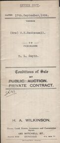
Conditions of sale by private contract dated 17th September, 1934 between Mrs. M.H. Beckensall (seller) and D.L. Smyth for land situate corner McIvor Road and Donovan, Bendigo being Crown allotment 1 section 93C described in Crown grant volume 265 folio 52937. Price 200 pounds. Vendor's copy.organization, business, h.a. & s.r wilkinson real estate -
 Bendigo Historical Society Inc.
Document - H.A. & S.R. WILKINSON COLLECTION: CONTRACT OF SALE
Conditions of sale by private contract dated 17th September, 1934 between Mrs. M.H. Beckensall (seller) and D.L. Smyth for land situate corner McIvor Road and Donovan, Bendigo being Crown allotment 1 section 93C described in Crown grant volume 265 folio 52937. Price 200 pounds. Office copy.organization, business, h.a. & s.r wilkinson real estate -
 Bendigo Historical Society Inc.
Document - H.A. & S.R. WILKINSON COLLECTION: CONTRACT OF SALE
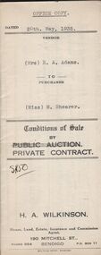
Conditions of sale by private contract dated 20th May, 1935 between Mrs. E.A. Adams (seller) and Miss M. Shearer (buyer) for land situate 43 Jackson Street, Long Gully being Crown allotment 181 section A and described in certificate of title volume 5564 folio 1112609, together with 4-roomed weatherboard dwelling and all sundry. Price 190 pounds. Also 2 receipts from City of Bendigo for rates.organization, business, h.a. & s.r wilkinson real estate -
 Bendigo Historical Society Inc.
Document - H.A. & S.R. WILKINSON COLLECTION: CONTRACT OF SALE
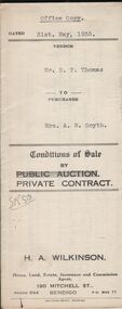
Conditions of sale by private contract dated 31st May, 1935 between Mr. E.T. Thomas (seller) and Mrs. A.M. Smyth for land, as fenced, situate corner Hargreaves and Wattle Streets, Bendigo, being Crown allotment 25 section 97C described in certificate of title volume 1662 folio 332318. Also land adjoining the above, together with 6-roomed weatherboard dwelling and all sundry. Price 435 pounds.organization, business, h.a. & s.r wilkinson real estate -
 Bendigo Historical Society Inc.
Document - H.A. & S.R. WILKINSON COLLECTION: CONTRACT OF SALE
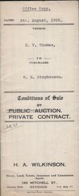
Conditions of sale by private contract dated 5th August, 1935 between E.T. Thomas (seller) and W.H. Stephenson (buyer) for land situate in Shipp Street, Bendigo being part of Crown allotment 308 section H, having a frontage of 66 feet to Shipp street by a depth of 155 feet 1 inch, being the south-western half of the said block. Price 135 pounds.organization, business, h.a. & s.r wilkinson real estate -
 Bendigo Historical Society Inc.
Document - H.A. & S.R. WILKINSON COLLECTION: CONTRACT OF SALE
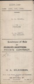
Conditions of sale by private contract dated 14th October, 1935 between W.G. Brooks (seller) and W.A. Swift the Younger (buyer) for land situate No. 293 King Street, Bendigo being Crown allotment 2 section 43A described in Crown grant volume 3020 folio 603887, together with weatherboard dwelling and all sundry. Also electric light fittings, bath, copper and troughs. Price 255 pounds.organization, business, h.a. & s.r wilkinson real estate -
 Bendigo Historical Society Inc.
Document - H.A & S.R. WILKINSON COLLECTION: CONTRACT OF SALE
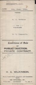
Conditions of sale by private contract dated 5th June, 1936 between W.J. McMahon (seller) and N.L. Svanosio (buyer) for land situate No. 64 Neale Street, Bendigo being parts of Crown allotments 200 and 201A section H, being the whole of the land remaining untransferred in certificate of title volume 4300 folio 859955, together with 5-roomed weatherboard dwelling and all sundry. Price 400 pounds.organization, business, h.a. & s.r wilkinson real estate -
 Bendigo Historical Society Inc.
Document - H.A. & S.R. WILKINSON COLLECTION: CONTRACT OF SALE
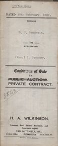
Conditions of sale by private contract dated 10th February, 1937 between D.J. Gaughwin (seller) and Mrs. I. Spooner (buyer) for land situate No. 27 Hamlet Street, Bendigo being Crown allotment 5 section 98C being land described in certificate of title volume 1681 folio 336040, together with 5-roomed weatherboard dwelling and all sundry. Also gas stove, all roller blinds, electric light fittings e globes, wire doors, wire screens and both heaters. Price 625 pounds.organization, business, h.a. & s.r wilkinson real estate -
 Bendigo Historical Society Inc.
Document - H.A. & S.R. WILKINSON COLLECTION: CONTRACT OF SALE
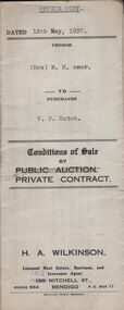
Conditions of sale by private contract dated 13th May, 1937 between Mrs. M.H. Amor (seller) and V.F. Sutch (buyer) for land situate Hayes Street, Bendigo being lot 2 on plan of subdivision, having a frontage of approx. 57 feet to Hayes Street, by a varying depth, being part of Crown allotment 510 section A. Price 60 pounds.organization, business, h.a. & s.r wilkinson real estate -
 Bendigo Historical Society Inc.
Document - H.A. & S.R. WILKINSON COLLECTION: CONTRACT OF SALE
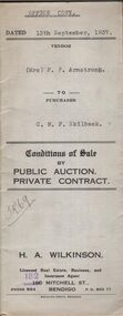
Conditions of sale by private contract dated 13th September, 1937 between Mrs. F.P. Armstrong (seller) and C.M.F. Skilbeck (buyer) for land situate 106 Thistle Street, Bendigo being part of Crown allotment 14 section 16B described in certificate of title volume 4386 folio 877150, together with 4-roomed weatherboard dwelling and all sundry. Price 300 pounds. Office copy.organization, business, h.a. & s.r wilkinson real estate -
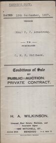 Bendigo Historical Society Inc.
Document - H.A. & S.R. WILKINSON COLLECTION: CONTRACT OF SALE
Conditions of sale by private contract dated 13th September, 1937 between Mrs. F.P. Armstrong (seller) and C.M.F. Skilbeck (buyer) for land situate 106 Thistle Street, Bendigo being part of Crown allotment 14 section 16B described in certificate of title volume 4386 folio 877150, together with 4-roomed weatherboard dwelling and all sundry. Price 300 pounds. Vendor's copy.organization, business, h.a. & s.r wilkinson real estate -
 Bendigo Historical Society Inc.
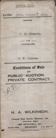
Document - H.A. & S.R. WILKINSON COLLECTION: CONTRACT OF SALE
Conditions of sale by private contract dated 26th October, 1937 between J.B. Edwards (seller) and G.F. Sansom (buyer) for land situate ''Hazelbrae'' Corner Russell and Hamlet Streets, Bendigo and occupied by tenant, having a frontage of 82 feet 6 inches to Russell street by a depth of 68 feet 6 inches to Hamlet Street and being part of Crown allotment 22 section 74Cand described in certificate of title volume 3289 folio 657653, together with 5-roomed brick and weatherboard dwelling and all sundry.. Price 465 pounds.organization, business, h.a. & s.r wilkinson real estate