Showing 13848 items matching "tasmanian-built"
-
 Glenelg Shire Council Cultural Collection
Photograph, John Wilkins, Photographer, Corkscrew, n.d
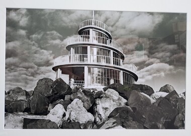
From the Port of Portland website: The original corkscrew was built as a gift to the Portland Harbour Trust by the contractors who constructed the port. It was designed in 1960 and fabricated shortly after the completion of the Main Breakwater. The corkscrew was built as an observatory, with the observation deck approximately 13 metres above sea level. Its original design life was less than 25 years. The original structure was dilapidated, extremely unsafe and in danger of collapse. Understanding the historical and community importance of the original structure, in 2016 Port of Portland began the process of designing and building a replacement. The new corkscrew is a similar size and has been based on the same spiral shape of the original structure. The corkscrew has been constructed using mild steel, heavily coated in marine grade paint (similar to what is used on ships). Heavy duty plastic has been used for the walkway section which will withstand the harsh elements of the marine environment.Photograph of the Portland Corkscrew in the 1980s. Image is in black and white. The corkscrew is in front of a sky which is dotted with fluffy clouds. To the front of the Corkscrew are large rocks. The building is a spiral with glass windows. There is a white metal fence around it and a white pole at the top which reaches to the top of the image.Bottom right: J WILKINSportland, seafront, maritime, portland landmark, corkscrew, port of portland, portland photography, photography -
 Bacchus Marsh & District Historical Society
Photograph, Home and surgery of Doctor Rae, Bacchus Marsh 1883
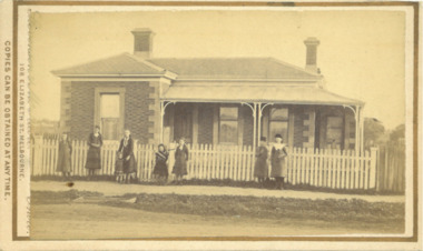
This image is one of a series of photographs taken by Melbourne based photographers Stevenson and McNicoll who visited Bacchus Marsh and its nearby districts between September and November 1883. The photo is of a brick residence, built in 1865-66 as a house and surgery for Dr. Rae, a medical practitioner in Bacchus Marsh 1863-1874. Dr. Rae was influential in community affairs as a Justice of the Peace, a member of the Board of Advice of Bacchus Marsh Common School and a President of the Mechanics’ Institute. After ill health forced him to resign his practice, he built the Bungalow in 1880, where he lived until his death. The house was later purchased by William Anderson (c.1880) who named it “Dunglass”. The people in this photograph are probably members of the Anderson family. The house is now used as an Adult Education Centre. The house is of significance as the embodiment of the importance to the community of its influential figures, such as Dr. Rae, in the late nineteenth and early twentieth centuries. Small sepia 'carte de viste' style unframed photograph on card with gold border framing photograph. Housed in the Jeremeas Family Album which contains photographs of Bacchus Marsh and District in 1883 by the photographers Stevenson and McNicoll. The photo is of a double-fronted brick Classical nineteenth century house with a high hip roof. Two brick chimneys are visible. The left hand bay is set forward, with the central section of the house being set back. A concave return verandah supported by decorative columns runs along the front and side of the house, leading to a separate entry door off the side verandah. On the window set in this door, the word ‘SURGERY’ can be discerned, indicating that this is the entrance to be used by patients. The building features buff-coloured stone quoins and architraves. A white picket fence runs along the front. Ranged along the footpath in front of the fence stands a group of eight young women and girls. A flat stone acts as a bridge over a deep drainage culvert running parallel to the street.Printed On the front: Stevenson & McNicoll. Photo. 108 Elizabeth St. Melbourne. COPIES CAN BE OBTAINED AT ANY TIME. On the back: LIGHT & TRUTH inscribed on a banner surmounted by a representation of the rising sun. Copies of this Portrait can be had at any time by sending the Name and Post Office Money Order or Stamps for the amount of order to STEVENSON & McNICOLL LATE BENSON & STEVENSON, Photographers. 108 Elizabeth Street, MELBOURNE. stevenson and mcnicoll 1883 photographs of bacchus marsh and district, doctors, houses bacchus marsh -
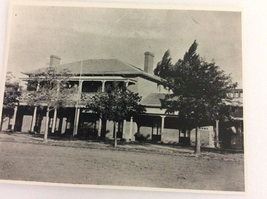
 Eltham District Historical Society Inc
Photograph - Digital Photograph, Alan King, Downing-Le Gallienne house, Yarra Braes Road, Eltham, 30 January 2008
The property is a classic example of what made Eltham famous from the late 1940s to the 1960s. Covered under Heritage Overlay, Nillumbik Planning Scheme. Published: Nillumbik Now and Then / Marguerite Marshall 2008; photographs Alan King with Marguerite Marshall.; p149 The first view of the large double-storey house at Yarra Braes Road, Eltham South, is of a jutting roofline over a balcony, reminiscent of a large sailing vessel or galleon – very appropriate, considering the name of one of the first owners, Le Gallienne. The Downing-Le Gallienne property is a classic example of what made Eltham famous from the late 1940s to the 1960s and attracted so many artists and intellectuals to the area. Set in a largely indigenous bush-style garden, the mud-brick and timber house was built by Alistair Knox. It was built for economist Richard Downing, to become a founder of the welfare state in Australia and Chairman of the Australian Broadcasting Commission, and musician and composer Dorian Le Gallienne. Le Gallienne was a pioneering composer of modern music in Victoria before 1945, whose works included the Symphony in E.1 He wrote several pieces of film music for Eltham Films, including The Prize, working with its writer and artistic director Tim Burstall. Le Gallienne was also a music critic for The Argus and later for The Age. In 1967 the music critic Roger Covell argued that Le Gallienne’s Symphony, was ‘still the most accomplished and purposive . . . written by an Australian’. According to Alan Marshall the main inspiration behind the building that evolved from 1948 to 1964 was Le Gallienne. ‘He was able to see value in the simplest things and many who worked there had their eyes opened for the first time to the Eltham environment, to the bush and the trees and the fauna which lived there.’ The garden included no formality, no lawns, nor exotic plants. ‘Natural informal growth came right up to their doors and so did the indigenous birdlife.’ This informal style – consisting of mass and void – was to be developed and popularised by landscaper Gordon Ford from the 1950s. The large mud-brick and timber house, which was built in four stages and has three separate but linked sections, began as a small weekend retreat for the couple. In 1948, Downing and Le Gallienne (Dick and Dor to their friends), asked Knox to build the 36 x18 foot (11mx5.4m) building with a pitched slate roof. It was built on a concrete slab and included a fireplace, which is still in use. The second wing was built in 1954 after Downing had returned from working at the International Labour Office and the couple decided to live there full-time. The third section was built after the death of Le Gallienne in 1963, aged 48. He is buried in the Eltham Cemetery. When Downing married widow, Jean Norman (nee McGregor) and had to accommodate a large family, including her six children and one of their own, the last stage was built by 1964. At that time the house was considered one of the largest mud-brick houses in Victoria. It consists of five living areas, including a small ballroom. Several artists helped Knox build the Downing-Le Gallienne house, which was one of his first of mud-brick. They included painter Clifton Pugh, artist John Howley and actor Wynn Roberts. Ellis Stones had landscaped the first wing and Gordon Ford set the boulder steps and made a pool as part of the landscaping he completed. Inside, the mud-bricks are largely whitewashed with pine-lined ceilings and Oregon beams. A winding timber staircase in the front extends behind a glass window from the ground floor to the top. The property, of a little more than 0.5 ha, is bordered by Parks Victoria land, which extends to the Yarra River.This collection of almost 130 photos about places and people within the Shire of Nillumbik, an urban and rural municipality in Melbourne's north, contributes to an understanding of the history of the Shire. Published in 2008 immediately prior to the Black Saturday bushfires of February 7, 2009, it documents sites that were impacted, and in some cases destroyed by the fires. It includes photographs taken especially for the publication, creating a unique time capsule representing the Shire in the early 21st century. It remains the most recent comprehenesive publication devoted to the Shire's history connecting local residents to the past. nillumbik now and then (marshall-king) collection, dorian le gallienne, downing-le gallienne house, eltham, mudbrick construction, mudbrick houses, richard downing, yarra braes road -
 Orbost & District Historical Society
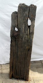
timber post, 1880's
This was retrieved in 1982 by Geoff Stevenson. It was a part of the original jetty at Tabbara on the Brodribb River used by Samuel Richardson who established his mill in .1882. The first saw mill plant at Orbost was set up early in 1876, There was a constant demand for timber to supply the growing townships of Orbost , Marlo and surrounds. It was at this mill that the original paddle steamer Curlip was built. More information in "Curlip" by May Leatch.The Richardson family was one of the very early settler families to establish themselves in the Orbost district. Before the Richardson's mill was established, settlers in the Snowy region either rough cut their own timber or had to bring it in from mills some distance away.A portion of a post from the old Tabbara jetty on the Brodribb River - Samuel Richardson's mill . There is still some original preserving tar on it. It has two holes, one with a bolt attached. It is possibly made from mahogany cut on the site.richardson-samuel tabbara-jetty brodribb-river -
 Orbost & District Historical Society
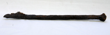
bridge spike
This spike came from the old Brodribb River bridge which is about 9.6 kilometres from Orbost. The Brodribb River joins the Snowy River north of Marlo. In 1906, a bridge replaced the punt over the Brodribb River, improving communication with Orbost. It was eventually replaced by a reinforced concrete bridge built by the Road Construction Authority in 1989 where the Princes Highway passes over the Brodribb RiverThis item belongs to a significant local structure which has been replaced.A very rusty iron bridge spike from the old Brodribb Bridge.brodribb-river bridge-spike -
 The Beechworth Burke Museum
Photograph, Kathy Adamo, "Lit by a Bygone Era", 1980s
The photograph was submitted to the Indigo Shire Photo Competition by Kathy Adamo in the 1980s. The photo depicts two old gas lamps outside the Court House in Beechworth. The Court House was built in 1856 after Beechworth became known as the legal headquarters in northeast Victoria. The Court House has held a number of trials over the years including many high-profile cases such as the Ned Kelly Trials.Black and white rectangular photo printed on paper mounted on black card.Reverse: TO Indigo Shire Council Photo Comp / Title 'Lit By A Bygone Era' / 05. BMM 8832 / Gas Lamps Outside Courthouse Beechworth / From / Kathy Adamo / RMB 4057 / Wangaratta / 21 6742 / Contents / Nikon F301 28-105 / Exposure Unknown / Most Historicalned kelly, 1956, beechworth, beechworth court house, indigo shire, indigo shire photo competition, kathy adamo, 1980s, gas lamps, lit by a bygone era -
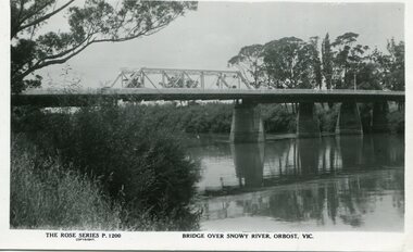 Orbost & District Historical Society
black and white photograph, Rose Stereograph Company, first half 20th century
A new bridge over the Snowy River at Orbost was opened for traffic on June 20th 1922. It was a new timber and steel girder structure, a joint Country Roads Board — Victorian Railways venture and was built and completed at a cost of £41,000 (the steel girders came from the Flinders Street viaduct reconstruction). Subsequently it was decided not to take the railway across the river, and the bridge was only ever used by road traffic. Postcards form a vital part of social and historical records for researchers. This postcard is a pictorial record of an earlier bridge across the Snowy River at Orbost.A black / white postcard photograph of a bridge over the Snowy River at Orbost.0n front - The Rose Series P1200 copyright Bridge Over Snowy River Orbost Vic.snowy-river-bridge -
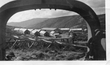 Kiewa Valley Historical Society
Photograph - Pretty Valley camp including workman's huts, Pretty Valley
At the Pretty Valley Dam site erection of staff quarters was completed in April, 1947 and accommodation for workmen commenced in 1948 but suspended on 11th May for winter and resumed on 9th November. Construction of this camp was completed in 1949. A large dam was proposed at this site but was never constructed. Instead a small diversion dam was built which diverts water either to Rocky Valley Dam or to McKay Creek Power Station.An historical record of the type of accommodation provided for workmen during the construction of the Kiewa Hydro Scheme during the 1940's/50'sBlack and white photograph of Pretty Valley camp showing workman's huts and construction materials.Handwritten on back of photograph in blue pen - Pretty Valleypretty valley, workmen's huts, victorian alps, secv -
 Kiewa Valley Historical Society
Folder - Early Photos of Mt Beauty
Mt Beauty township was built during the 1950's to house the employees of the State Electricity Commission working on the Kiewa Hydro Electric Scheme. After the completion of the Kiewa Hydro Electric Scheme many houses were sold and the public buildings handed over to the Alpine Shire. Mt Beauty has always been a tourist destination especially with its proximity to the ski fields at Falls Creek.This folder contains many early photos of Mt Beauty showing the construction town during its development during the Kiewa Hydro Electric Scheme and its early days of tourism. A3 size black plastic folder with clear plastic sleeves holding early black & white photos of Mt Beauty township. Also included are: 1. 3 foolscap pages -Nov., 1953 Kiewa Hydro-Electric Scheme Progress. 2. SECV Drawing Plan (No. K6242) of Mt Beauty House - 3 angles and floor plan, English Pre-cut Type 3B.ILA with note that all houses with prefix 3B are similar. 3. Orange, black and white pamphlet "Welcome to Kiewa" 4. Tourist postcard 'fold-up' of 11 postcards "Mt Beauty and the Kiewa Scheme, Victoria 5. Drawing Plan of 'Mt Beauty Housing. Use of Prefabricated Cubicles for Houses. Type C.1 6. Drawing Plan of 'Kiewa Scheme Mt Beauty Housing Type "G". 7. 5 pages on "Twelve Tips on Caring for Old Buildings 8. Booklet advertising Mt Beauty housing for sale including activities available in the area. (1960's) 9. List of Photos from SECV held by KVHS Some photos have handwritten labels mt beauty. secv. kiewa hydro electric scheme.tourism. housing. construction town. falls creek. -
 Port of Echuca
A black and white photograph, The Bridge Hotel, in 1896, showing Silky Oak trees, 1970's
The Bridge Hotel was built by Henry Hopwood to house visitors to the town crossing the Murray River on his punt crossing, which was situated just below the Bridge Hotel on the Murray River. The accommodation was spacious and grand! In the right back corner of the photograph, the 'lantern' roof of the St Georges Hall can be seen. The street is level with the front entrance to the Hotel, which is very different to what it is today.The photograph shows hotel activities and accommodation in the late 19th Century.A black and white photograph of the Bridge Hotel taken from the Hopwood Gardens. The photograph shows four silky oak trees growing along the front of the building. There is an empty flag pole outside the front of the building. The right wing advertises billiards, whilst the left wing apparently was a bar.Written on the building can be seen the words; HOTEL and BILLIARDS. Written in pen on the back of the photograph are the words "Bridge Hotel. Probably 1896, showing Silky Oak trees.bridge hotel, henry hopwood, silky oak trees, lantern roof, st georges hotel -
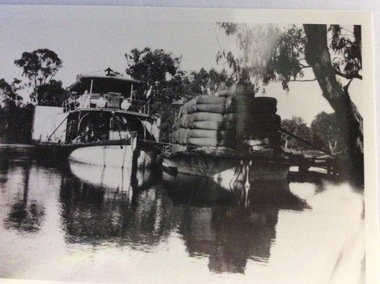 Port of Echuca
Photograph, Early 20th Century
The P.S Australien was built in 1897 by Richard Wilson, of Moama. In 1937 the vessel was used to tow boilers, winches and derricks to the banks of the Murray River to aide in the construction of Locks 6,7,9 and Yarrawonga Weir. The barge is viewed from the rear, as the rudder can be seen, and shows the enormity of the loads of wool which a barge could carry. The two vessels are tied together and appear to be moored at a small pier.The P.S Australien is one of the oldest paddle steamers built at Echuca. It was a working vessel during the construction of the Yarrawonga weir in the 1930s which was the beginning of the irrigation system which enabled the Agriculture Industry to become such a prominent part of the Murray-Darling River Basin social history. A paddle steamer and a barge, loaded with wool, are seen docked together on a river. There is a small wooden jetty leading to the bank where gum trees are growing.p.s australien, yarrawonga weir, echuca paddlesteamers, murray river paddle steamers, wilson, richard, wool industry -
 Eltham District Historical Society Inc
Photograph, Fay Bridge, Centenary celebration, Monash Bridge, Hurstbridge, 7 November 2017
The area of Hurstbridge was originally known as Hurst’s-bridge after the timber bridge built over the Diamond Creek near Hurst’s station in late 1881/early 1882. It was replaced by a new concrete bridge designed by Sir John Monash over the Diamond Creek near Hurst's home of 'Mia Mia' at Hurstbridge. The official opening of the new Monash bridge at Hurstbridge was held 3 November 1917.fay bridge collection, 2017-11-07, hurstbridge, hurstbridge heritage trail, monash bridge, ruins -
 Glen Eira Historical Society
Document - Lempriere Avenue, 10, St. Kilda East
A brief history of the property at 10 Lempriere Avenue, St. Kilda East, built on a subdivision of the land of William George Lempriere. Includes some information on the Lempriere Family and public park, Greenmeadows Gardens. The document by Rosalind Landells, David Bick and Hilary Bullock of the Brighton Historical Society is dated October 30, 1995. Includes handwritten notes covering mostly same information. Includes bibliography.greenmeadows, lempriere william george, clarke william senior, lempriere john thomson, zimmerman a.k., nelson frank l., greenmeadows gardens, lempriere avenue, nelson m.d., st. kilda east, parks and reserves, zucker a.a., greenmeadows lane, lempriere family, lempriere’s paddock, councillors -
Glen Eira Historical Society
Document - Bramerton, Bambra Road, Caulfield
One page undated, unattributed, typed note about Bramerton, Bambra Road, listing owner, date, property description and acreage. The file also includes a one page handwritten, undated note about Bramerton, Bambra Road, built for Arthur Palmer Blake, mentioning the property’s possible use as a military convalescent hostel in 1918. This was researched from book Land Boom and Bust by Cannon.bramerton, bambra road, blake arthur palmer, crotonhurst, stables, military hospital, nursing home, armed forces, caulfield -
 Greensborough Historical Society
Photograph - Digital Image, Cherel Sartori, Claude Amiet at Kell's Cottage 1920s, 1920c
Photograph of Claude Amiet and others at Kell's Cottage in the 1920s. The house was built 1917, at 112 Henry Street Greensborough by William Mitchell on the 60 acre dairy farm owned by Ethel and Walter Kell. This collection of photographs was copied by Cherel Sartori (who owned the house from 1990-2000), following a visit by Claude Amiet who lived in the house as a child in the early 20th century.Digital copy of black and white photographkell's cottage, claude amiet, cherel sartori -
 Greensborough Historical Society
Photograph - Digital Image, Cherel Sartori, Looking east from Henry Street to the river 1956, 01/01/1956
Looking from Henry Street east to the Plenty River, 1956. The house was built 1917, at 112 Henry Street Greensborough by William Mitchell on the 60 acre dairy farm owned by Ethel and Walter Kell. This collection of photographs was copied by Cherel Sartori (who owned the house from 1990-2000), following a visit by Claude Amiet who lived in the house as a child in the early 20th century.An indication of the rural aspect of this area in the mid-20th century.Digital copy of black and white photographkell's cottage, claude amiet, cherel sartori -
 Kiewa Valley Historical Society
Photograph of Pretty Valley Workers Camp*, Pretty Valley Camp, circa 1949
Erection of staff quarters at Pretty Valley was completed in April, 1947 and accommodation for construction workers commenced in 1948 but suspended on 11th May for winter and resumed on 9th November. Construction of this camp was completed in 1949. A large dam was proposed at this site but was never constructed. Instead a small diversion dam was built which diverts water either to Rocky Valley Dam or to McKay Creek Power Station.An historical record of the type of accommodation provided for workmen during the construction of the Kiewa Hydro Scheme during the 1940's/50's.A black and white photograph of Pretty Valley Camp, c 1949. Dead trees are in the foreground, on both the left and right side of the photograph and a small snow gum is evident. There are camp huts and a much larger building behind these, possibly a workshop, and power poles are evident bringing electricity to the site.Handwritten in blue ink on back of photograph "Pretty Valley Camp. 5600 ft. above sea level".pretty valley, dam, water, workmen, camp -
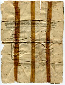 Orbost & District Historical Society
ticket, 1880's
The Potosi was built in Scotland in 1873 by John Elder and Co.It was a cargo/passenger iron screw steamer and sailed from 1880-1887 under the Orient Line Australia service. Samuel James Lynn was born in 1865 in Coleraine, Northern Ireland. Sam left his home in Coleraine in 1883 at the age of 17. (More information in O.D.H.S. newsletter No. 91 September, 2012 by Margaret Hollands) Samuel Lynn was a well-known Orbost pioneer. Ho owned much property throughout the district , bred Clydesdale horses and fattened about 600 cattle. He was in great demand as a judge of both cattle and horses at agricultural shows in Victoria and interstate. He was a shire councillor for 30 years and president several times. He took a great interest in the sporting clubs of the town and played cricket until late in life. He was goal umpire for the local football team for many years, judged for the Orbost Racing Club and was the first president of the Orbost Bowls Club. He was also a member of the first municipal band. A paper passenger's contract ticket for Samuel Lynn on the Steam Ship Potosi from Royal Albert Dock, Liverpool, United Kingdom to Melbourne, Australia. It is white with black print and hand-written details.front - signed "Samuel Lynn"lynn-samuel potosi-steamship -
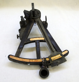 Orbost & District Historical Society
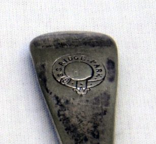
sextant, W. Sutherland
RIDGE PARK, Length: 65.2 m.; Owned by H. Simpson & Sons; Built at S. P. Austin & Sons in 1878. Registered at Adelaide. On 10 February 1881, RIDGE PARK (Capt. Heslop) was on voyage from Adelaide to Sydney with a cargo of brandy, wine and flour, when she was lost after running aground.Beware Reef is located south east of Cape Conran in east Gippsland. This is the sextant from the Ridge Park which, on10 February 1881, was wrecked on Beware Reef , just south of Cape Conran in east Gippsland. An old wooden sextant from the ship, Ridge Park. It is black with yellow measuring stripes.sextant maritime navigational -
 Orbost & District Historical Society
cutlery box, Jensen, Peter, Early 20th century
Made for Danebo Guest House at Martin's Creek. Peter Jensen came to Martin's Creek (35 miles north of Orbost) in 1890 having been told that Martin's Creek would be on the railway line. He was a cooper who made the casks from silver wattles. He cleared the area for farming and then built an accommodation house, Danebo., which was well used by travellers to Bonang and Bendoc. Gippsland was a relatively less developed part of Victoria in the nineteenth century. Danebo Hotel, Martin’s Creek, would have been an important stopping point for travellers to Bonang and Bendoc. The hotel is no longer standing.A open rectangular shaped wooden cutlery box - probably hand-made.. It has a carrying handle cut into the divider.jensen-peter martin's-creek danebo cutlery-box container -
 Orbost & District Historical Society
cutlery, 1880's
RIDGE PARK, Length: 65.2 m.; Owned by H. Simpson & Sons; Built at S. P. Austin & Sons in 1878. Registered at Adelaide. On 10 February 1881, RIDGE PARK (Capt. Heslop) was on voyage from Adelaide to Sydney with a cargo of brandy, wine and flour, when she was lost after running aground.Beware Reef is located south east of Cape Conran in east Gippsland.This cutlery is from the Ridge Park which, on 10 February 1881, was wrecked on Beware Reef , just south of Cape Conran in east Gippsland.Two forks and two spoon which are silver plated dinner cutlery.On front of handles - S.S.Ridge Park On back of handles - EP & NS with an A inside a circle -
 Federation University Historical Collection
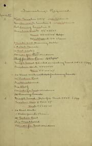
Document, Ballarat Junior Technical School: Furnishings Required for Each Room, c1921
The Ballarat Junior Technical School was a division of the Ballarat School of Mines. The furnishing requirements list what is needed for each room within the new school - Ballarat Junior Technical School - that was built near the Ballarat School of Mines. One sheet indicates the furniture already on hand. This would be the items that were owned by the Junior Technical School while they were located at Dana Street State School.Handwritten lists on foolscap paperballarat junior technical school, ballarat school of mines, buildings, furnishings, steane, dana street, new school -
 Federation University Historical Collection
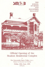
Document - Invitiation, Invitiation and Programme for the opening of the Ballarat School of Mines Complex at 130 Victoria Street, Ballarat East, 1991, 28/06/1991
The opening of the Complex on 28 June 1991 marks a significant step in the capacity of the Ballarat School of Mines to provide quality, modern, purpose built and comfortable accommodation for student. Funding for the project came primarily from the sale of Ballarat School of Mines hostels owned by the Education Department in Webster Street which allowed the construction and refurbishment at 128-130 Webster Street to became an impressive complex.An invitation and programme on cream card with marron images and text. Each photo shows an image of 130 Victoria Street, Ballarat East. .1 & .2) Programme for the Official Opening of the Ballarat School of Mines Student Residential Complex at 130 Victoria Street by the Honourable Barry Pullen, M.L.C., minister for Education and training, on 28 June 1991. .3 7 .4) Invitation to attend the official opening of the Ballarat School of Mines Student Residential Complex at 130 Victoria Streetballarat school of mines student residential complex, ballarat school of mines, 130 victoria st, hostel, student residence, barry pullen, barker, jack barker, e.j. barker, terry moran, anne fennell -
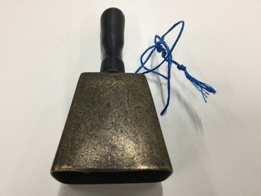 Murtoa & District Historical Society and Museum
Bell, unknown
Bell brought from Longerenong Homestead by former boundary rider William McClintock. Given to John Hamilton and used on his farm to call the men to dinner. In 1922 it was used as a school bell when Higher Elementary School classes began in the Firebrigade Hall and in the Methodist & Presbyterian hall untill the Murtoa H.E.S. was built in 1925 and their own bell was purchased. The bell was donated by Miss Grace Hamilton.The Bell is significant as it was originally the property of William McClintock - one of the original settlers to obtain land in Murtoa around 1872. Its significance is enhanced by its connection to the Hamilton family and its use on the farm and later its use in the temporary school setting.Metal bell with wooden handle and metal clapperwilliam mcclintock, bell, murtoa higher elementary school, john hamilton -
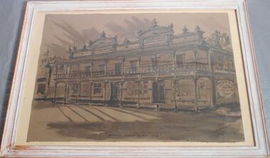 Bendigo Historical Society Inc.
Drawing - Bendigo Coffee Palace, Bill Klemmer
Erected in 1888 by Robert Milburn and family, the coffee palace on the corner of Mollison and Mitchell Streets was opposite the entrance to the railway station and as such provided ready access for travellers. Built at a cost of L4000, it consisted of 40 rooms that provided retail outlets and a ballroom on the ground floor and accommodation on the upper level. In 1945 it was converted to provided hostel accommodation for 43 student teachers. The building was demolished in the 1980's.An ink and pencil drawing of the Bendigo Coffee Palace signed by Bill Klemmer in 1968. The drawing reproduces the building like it would have looked in 1875.bendigo, sandhurst coffee palace, drawing, bill klemmer -
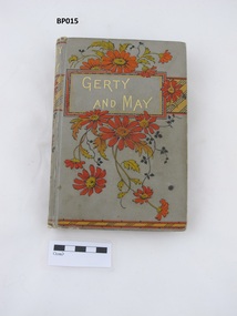 Uniting Church Archives - Synod of Victoria
Book, Griffith, Farran, Okeden and Welsh, Gerty and May, c1893
Grey linen covered book with terracotta, yellow, black and gold decoration and text. There is a bookplate inside the front cover. 136p with black and white lithographic illustrations by Henry Courtney Selous. fictionewing memorial presbyterian sabbath school east malvern, lily mclean, j mckenzie king presbyterian sabbath school superintendent, mrs beynon presbyterian sabbath school teacher -
 Uniting Church Archives - Synod of Victoria
Book, Frederick Warne and Co, Katie or the simple heart, 1887
Brown linen covered book with blue, black and gold design on the front and spine. 320 gilt edged pages. Author: D. Richmond with black and white illustrations. There is a bookplate inside the front cover.fictionewing memorial presbyterian sabbath school east malvern, lily mclean, mrs beynon presbyterian sabbath school teacher, john king presbyterian sabbath school superintendent -
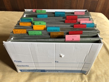 Robin Boyd Foundation
Container - Hanging Files
Robin Boyd used these hanging files for personal and professional documents. They are labelled "Puzzle of Architecture & Living in Australia". 'Stegbar", 'Letters", 'Flying Dogtor", 'Publications", 'Crawfords", 'Club", 'The Australian", 'Miscellaneous", "Historical Notes". 'The Aist'n Ugliness", 'Trips", "290 Walsh St", "Car", "insurance", "Foster Parents", "Penleigh & Suzy" and some are untitled. These were kept in a special built in space in the upstairs south shelves.walsh st miscellaneous, robin boyd -
 Hume City Civic Collection
Photograph
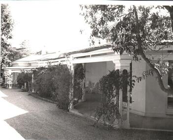
'Glenara' is situated along the Deep Creek at Bulla and was built on an original government grant of land by Walter Clark. His fourth child, Alistair, spent much of his life there and with the help of his gardener, W.Peers, gained world recognition for introducing 150 new rose species which included the Black Boy and Lorraine Lee. He was also founder of the Moonee Valley Racing Club.A black and white photograph of a Victorian home with a return verandah across the front and side. Vines are growing up the metal verandah posts and across the front of the verandah.glenara', rose gardens, roses, clark, alistair, walter, moonee valley racing club, george evans collection -
 Hume City Civic Collection
Photograph, c 1974
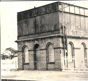
The mounted photograph is one of a series used for display purposes. The water tower at Sunbury Station was built in 1861 by J. Bett. it is of state significance and is an indicator of the importance of the railway to Sunbury's expansion in the Nineteenth Century. Steam trains needed sufficient steam power to climb the steep gradients over the Great Dividing Range and the water tower at Sunbury was used to replenish the trains' water supply for the remainder of the journey.A black and white photograph of the water tower at Sunbury Railway Station. The base of the tower is a brick construction with an arched doorway and two bricked in arched windows at either side of the doorway and a further two bricked in arched windows on the side. Above the base is a large square iron water storage tank with two downpipes at the side. There is a picket fence either side of the building. Mounted on board.sunbury railway station, water towers, victorian railways, bett, j., george evans collection