Showing 6122 items matching "historical site"
-
 Warrnambool and District Historical Society Inc.
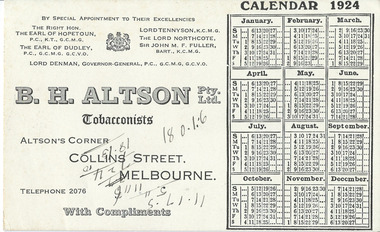
Document, Blotter Calendar 1924, 1924
As this blotter came with a collection of dockets etc from the Warrnambool Club it is assumed that it was a blotter used at the Club. It comes from the firm of B.H.Altson, a tobacconist, probably a supplier of goods to the Warrnambool Club. Henry Altson, a tobacconist, built an eight-storeyed building in 1903 at the corner of Elizabeth and Collins Streets in Melbourne (on the site of the first brick building in Melbourne). Altson’s tobacconist shop occupied the prime corner position for many years. The Warrnambool Club was a gentlemen’s club established in Warrnambool in 1873 and the Warrnambool Club building in Kepler Street erected in 1877 and the Club still exist. This blotter is of some interest as an example of the Melbourne firms patronized by the Warrnambool Club in 1924This is a piece of blotting paper advertising on one side the firm of B.H. Altson, Tobacconists, in Melbourne. It has a calendar for 1924. The printed material is black on a creamy-coloured surface. The blotting paper on the other side has been slightly used (blotted handwriting) There are also some handwritten figures scrawled across the advertisement, the meaning of which is not known.‘B.H. Altson Pty Ltd, Tobacconists, Altson’s Corner, Collins Street, Melbourne, Telephone 2076, With Compliments’.warrnambool club, b.h.altson,, tobacconist -
 Warrnambool and District Historical Society Inc.
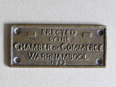
Brass Plate, Chamber of Commerce 1933, 1933
This plaque has been attached to a Warrnambool installation in 1933. It is not known to which site this refers but it may have been the Warrnambool Information Pavilion which was erected outside the old Warrnambool City Council Chambers. There have been many Warrnambool Chambers of Commerce over the years. These were established by Warrnambool businessmen and women to promote the interests of the town/city and to encourage the development of local industry and the tourism trade. This plaque is of great local interest but unfortunately does not have a clear provenance.This is a small brass plaque. The plaque has four holes at each corner for attachment to a building or other object. ‘Erected by the Chamber of Commerce, Warrnambool, 1933’warrnambool chamber of commerce, warrnambool city council chambers, plaque -
 Warrnambool and District Historical Society Inc.
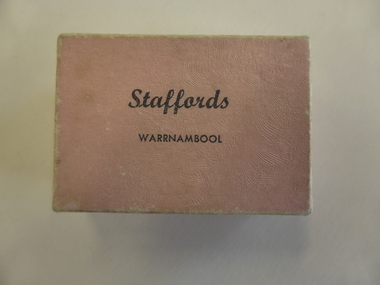
Box, Jewellery Box, Mid 20th century
This is a jewellery box from the Warrnambool business of Stafford, the jeweller. The Staffords shop was at 120 Liebig Street and operated in the 1960s, 70s, 80s, 90s and early 2000s. The site is still a jewellery shop. This box is of minor interest as an example of a small jewellery box from the mid 20th century.This is a small cardboard box covered with salmon-pink paper on the outside. It is empty but once contained an item of jewellery. The pink paper is slightly buffed. ‘Staffords Warrnambool’staffords, jewellers, warrnambool, jeweller box -
 Warrnambool and District Historical Society Inc.
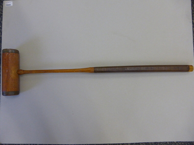
Mallet, Croquet Mallet, Late 19th century/early 20th century
This croquet mallet belonged to Martha Beatrice McCullough (nee Barker), wife of George McCullough, who died in November 1931 at the age of 50. She lived at the house at 113 Koroit Street named ‘Heatherlie’ (the site of the current retirement residential units) and owned and managed the Silver Stream Café in Liebig Street. The mallet was used by her and may have been used by her mother before her. Croquet was a popular sport, especially for women after the 1880s. This is a significant item as it is an artefact associated with women’s sport in the late 19th century and early 20th century. It is also important as it belonged to a local Warrnambool resident and businesswoman whose granddaughter resides in Warrnambool today.This is a brown-coloured wooden croquet mallet. The handle has ribbed leather binding and the mallet has brass edging and brass on the under section attached with twelve brass screws. The handle is octagonal shaped. The lower section of the handle and the mallet have been varnished. On the mallet: ‘The Reel’croquet, warrnambool -
 Warrnambool and District Historical Society Inc.
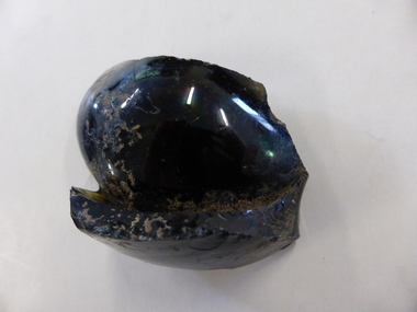
Bottle, Bottle fragment Woodford hotel est 1845, 19th century
This fragment was found in Bridge Road, Woodford on the site of the Travellers’ Rest Hotel, Woodford and it is believed that it may date from the time when the hotel was operating. The Travellers’ Rest Hotel in Woodford was established some time in the 1840s with the first known date, 1847. It pre-dates the settlement of Warrnambool founded in late 1847. The Travellers’ Rest Hotel was established by William Kirby and his wife Mary took over the hotel management when her husband was drowned in August 1847. The hotel had seven other licensees and closed in 1875. If this item comes from the time of the Travellers’ Rest Hotel in Woodford then it is of considerable interest as an early memento of that hotel and the early days of Woodford. This is a fragment of a black bottle or other domestic item. It is made of heavy glass and is curved and could be part of the base of the object. history of woodford, travellers’ rest hotel, woodford, warrnambool history -
 Warrnambool and District Historical Society Inc.
Book, Nurse Thompson's private hospital Journal, Early 20th century
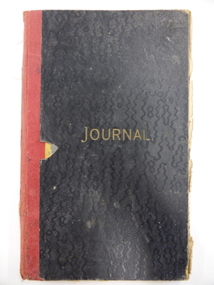
This journal contains the original records of Nurse Thomson’s Private Hospital in Warrnambool. It contains the records of the births at the hospital from 1907 to 1924. The early records give the name of the mother and later ones give the name of the attending doctor. Ellen Thomson (1872-1940), the daughter of Eliza and Charles Trew, conducted a private hospital in Raglan Parade, Warrnambool (the site of the old Tatts Hotel Bottle Shop, next to where McDonalds Food Store is today). This journal is of considerable significance as it is an original one, listing births at a private hospital in Warrnambool from 1907 to 1924. It is the only local original private hospital journal in the collection of Warrnambool and District Historical Society and pre-dates the establishment of a maternity wing at the Warrnambool Hospital.This is a foolscap-size book with a black hard cover and gold printing on the front. It has red binding which is in a somewhat tattered state. The cover is coming away from the binding and some pages are loose. The book has printed red and blue lines and the entries on these pages are handwritten in black ink and pencil. There is a loose sheet of paper giving information on the journal and the donor. nurse thomson, private hospitals in warrnambool, history of warrnambool -
 Warrnambool and District Historical Society Inc.
Poster, Lyndoch Sub-Division
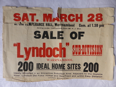
This is a poster advertising the sale of the Lyndoch sub-division in Warrnambool with the sale of 200 housing sites. The sale took place about 1958 with the land sold by Frederick Gill, a Warrnambool jeweller. The land was previously owned by George Rolfe who had acquired the land near the mouth of the Hopkins River in the 1880s and named the property ‘Lyndoch’. He bought the surrounding land at a later time. This sub-division came to be known as the Gill Estate. It was a valuable site as many of the allotments fronted the sea and others were adjacent to the Hopkins River. This poster, although tattered, is of interest as it has many details of the Gill Estate sub-division and will be useful to researchers. This is a cream-coloured paper poster with black and red printing. The poster has a small map in a circle shape showing the location of the streets and a larger map section showing the streets and the allotments to be sold. The poster is in two pieces and the edges are torn and, in some sections, missing. The streets map has some pencil annotations. history of warrnambool, lyndoch, warrnambool, george rolfe, frederick gill -
 Warrnambool and District Historical Society Inc.
DVD, Premier Speedway
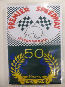
The Warrnambool Hot Rod Club was formed in 1958 at the Warrnambool racecourse. In 1969 the Club transferred to a site on the Princes Highway. Today the Club is the Premier Speedway Club and the major annual event is the Grand Annual Sprintcar Classic. This DVD was produced to celebrate the 50th Anniversary of the Warrnambool Premier Speedway Club. It is retained as a souvenir of that anniversaryThis is a DVD with two discs contained in a plastic folder. The cover of the folder is multi coloured and contains photographs of speedway vehicles, an image of two chequered flags, a helmet and a laurel wreath.PREMIER SPEEDWAY WARRNAMBOOL 50 Years 1958-2008premier speedway warrnambool, car racing warrnambool, history of warrnambool -
 Kiewa Valley Historical Society
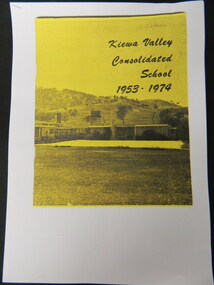
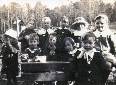
Booklet - Kiewa Valley Consolidated School x5, Kiewa Valley Consolidated School 1953 - 1974
Kiewa Valley Consolidated School was established in 1953 combining Dederang North, Kergunyah, Gundowring, Kiewa, Gundowring Upper, Red Bluff, Charleroi and Gundowing North schools on a 10 acre site with 11 rooms at Kiewa.The above schools are in the Kiewa Valley. The date and number of combined schools give insight into the change in population and families in the Kiewa Valley before and after 1953.Five A4 photocopied pages of a yellow and black booklet including the first 9 pages.kiewa valley consolidated school; dederang; kiewa valley; education -
 Kiewa Valley Historical Society
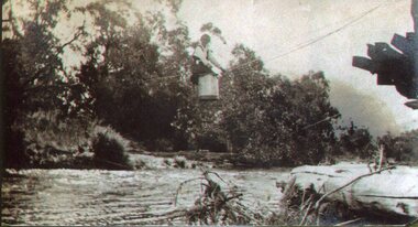
Photo - Tawonga Bridge.( Set of 2 photos)
Photo 1 - Rene Roper (Postmistress) crossing swollen Kiewa River on a milk can flying fox at Tawonga, during high winter waters Photo 2 - First Tawonga bridge was built in 1884- destroyed by floods in 1916. New bridge constructed 1923 and destroyed in 1953. Present concrete bridge constructed in 1986 and named Ryders BridgeBridge construction over Kiewa River at TawongaCopies of two original black and white photos. Photo 1 - Flying fox at site of Tawonga Bridge over the Kiewa River Photo 2 - Timber pile bridge over the Kiewa River at Tawongatawonga bridge, kiewa valley -
 Kiewa Valley Historical Society
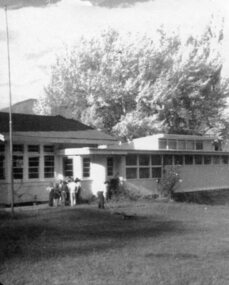
Photo - Tawonga South Primary School
Original site of the Tawonga South Primary School. Building is now used as Parks Victoria officesEarly site of Tawonga South Primary SchoolBlack and white photograph of original Tawonga South Primary Schooltawonga south primary school, state school, kiewa valley -
 Kiewa Valley Historical Society
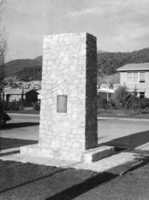
Photo - Mt Beauty Cenotaph
The cenotaph was built by Snowy Miller, stone mason. Site of Anzac Day commemorationsStone mason, Snowy Miller (father of Dot Higginson) constructed the cenotaph. He also worked on the Tawonga hall.Black and white photograph of the stone cenotaph in Mt Beautymt beauty centotaph, anzac day -
 Kiewa Valley Historical Society
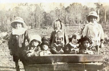
Photo - Tawonga Primary School pupils 1920, 1920
Tawonga Primary School Children 1920. Tawonga is in the Kiewa Valley where farmers lived with their families. The school was opened on 27th July 1880 situated on 8 acres near the current township of Tawonga. This school was erased by fire in 1900 and all records were destroyed. The school then moved to the old Tawonga Hall. In 1910 the school was shifted to its present site on 3 acres of land donated by Frank Cooper. The school building and attendance continued to grow especially during the construction of the Kiewa Hydro Electric Scheme. Early residents of the area. Ellie Seymour front row first on left. Walter J E Ryder in front of the desk at right. Vera Ryder behind him on the right. The boys also wore white collarsCopy of black and white photograph of pupils (children) at Tawonga Primary School 1920tawonga primary school, state school, kiewa valley -
 Kiewa Valley Historical Society
Photo - Bogong Township, March 1944
In 1940 Field Headquarters for the Kiewa Scheme were established at Bogong with office, workshop facilities and accommodation for workmen, staff and some families constructed. (There had been a 'tent camp' on this site in 1939 but was destroyed by bushfires) Construction of accommodation continued until 1947. A total of 40 houses plus a hostel for single staff, post office, police station, medical centre and primary school all with water and sewerage and electricity supply. The staff hostel was known as Kiewa House and is now occupied by the Education Department. Lake Guy was named after Mr. L.T. Guy who was the Resident Engineer in charge of construction work and associated activities on the Kiewa area. He held this position from 1939 to November 1946 when he was transferred to Head Office. The Bogong Township was developed firstly as an accommodation centre (base camp) for construction workers employed under the Kiewa Hydroelectric Scheme. Due to the influx of European workers into the Township the beautification of the immediate surrounds (gardens etc.) had a distinct European flavour. This environment has been very beneficial for tourism in later years. At the completion of the scheme, in the 1960's, the village was opened to public/tourism use. Strict environmental control has not allowed for any extensive redevelopment in tourist accommodation and basically restricted it to the accommodation initially built for the construction workers. Activities such a bike riding, snow skiing, restricted horse riding and bush walking on the Alpine plains and mountains are now a viable part of the Kiewa Valley Tourist Industry. The lake is one of the many water storage reservoirs used to supply the power stations their main power to run the huge turbines generating the final product, electricityBlack and white photograph of Bogong Township taken March 1944Handwritten on the back of photo - Township March '44bogong village, secv -
 Kiewa Valley Historical Society
Photograph - Bogong Village (7 copies), Approx 1940
In 1940 Field Headquarters for the Kiewa Scheme were established at Bogong with office, workshop facilities and accommodation for workmen, staff and some families constructed. (There had been a 'tent camp' on this site in 1939 but was destroyed by bushfires) Construction of accommodation continued until 1947. A total of 40 houses plus a hostel for single staff, post office, police station, medical centre and primary school all with water and sewerage and electricity supply. The staff hostel was known as Kiewa House and is now occupied by the Education Department. Lake Guy was named after Mr. L.T. Guy who was the Resident Engineer in charge of construction work and associated activities on the Kiewa area. He held this position from 1939 to November 1946 when he was transferred to Head Office. The Bogong Township was developed firstly as an accommodation centre (base camp) for construction workers employed under the Kiewa Hydroelectric Scheme. Due to the influx of European workers into the Township the beautification of the immediate surrounds (gardens etc.) had a distinct European flavour. This environment has been very beneficial for tourism in later years. At the completion of the scheme, in the 1960's, the village was opened to public/tourism use. Strict environmental control has not allowed for any extensive redevelopment in tourist accommodation and basically restricted it to the accommodation initially built for the construction workers. Activities such a bike riding, snow skiing, restricted horse riding and bush walking on the Alpine plains and mountains are now a viable part of the Kiewa Valley Tourist Industry. The lake is one of the many water storage reservoirs used to supply the power stations their main power to run the huge turbines generating the final product, electricity. Evidence can be seen of the 1939 bushfires.Set of 7 identical black and white photographs of Bogong Village after 1939 bush firesHandwritten on the back of one photo - Bogong Village approx. 1940, after 1939 bush fires. Staff residences to left. Kiewa House, General offices and test lab to the right. Hand drawn map on the back of one photo.bogong village, secv -
 Kiewa Valley Historical Society
Photo - Bogong Village Township, October 8, 1946
In 1940 Field Headquarters for the Kiewa Scheme were established at Bogong with office, workshop facilities and accommodation for workmen, staff and some families constructed. (There had been a 'tent camp' on this site in 1939 but was destroyed by bushfires) Construction of accommodation continued until 1947. A total of 40 houses plus a hostel for single staff, post office, police station, medical centre and primary school all with water and sewerage and electricity supply. The staff hostel was known as Kiewa House and is now occupied by the Education Department. Lake Guy was named after Mr. L.T. Guy who was the Resident Engineer in charge of construction work and associated activities on the Kiewa area. He held this position from 1939 to November 1946 when he was transferred to Head Office. The Bogong Township was developed firstly as an accommodation centre (base camp) for construction workers employed under the Kiewa Hydroelectric Scheme. Due to the influx of European workers into the Township the beautification of the immediate surrounds (gardens etc.) had a distinct European flavour. This environment has been very beneficial for tourism in later years. At the completion of the scheme, in the 1960's, the village was opened to public/tourism use. Strict environmental control has not allowed for any extensive redevelopment in tourist accommodation and basically restricted it to the accommodation initially built for the construction workers. Activities such a bike riding, snow skiing, restricted horse riding and bush walking on the Alpine plains and mountains are now a viable part of the Kiewa Valley Tourist Industry. The lake is one of the many water storage reservoirs used to supply the power stations their main power to run the huge turbines generating the final product, electricityBlack and white photograph of Bogong Village which appeared in the Herald Sun newspaper on October 8, 1946. Page 13Handwritten on the back - Town of Bogong on a rugged mountain slope above Lake Guy. State Electricity Committee workers on the Kiewa Hydro Electric scheme live here in all electric homes. Stamped on the back - Copyright Not for reproduction Herald Sun Feature Service Melbourne Australiabogong village; lake guy; kiewa hydro electric scheme -
 Kiewa Valley Historical Society
Postcard - Lake Guy and Bogong Village
In 1940 Field Headquarters for the Kiewa Scheme were established at Bogong with office, workshop facilities and accommodation for workmen, staff and some families constructed. (There had been a 'tent camp' on this site in 1939 but was destroyed by bushfires) Construction of accommodation continued until 1947. A total of 40 houses plus a hostel for single staff, post office, police station, medical centre and primary school all with water and sewerage and electricity supply. The staff hostel was known as Kiewa House and is now occupied by the Education Department. Lake Guy was named after Mr. L.T. Guy who was the Resident Engineer in charge of construction work and associated activities on the Kiewa area. He held this position from 1939 to November 1946 when he was transferred to Head Office. The Bogong Township was developed firstly as an accommodation centre (base camp) for construction workers employed under the Kiewa Hydroelectric Scheme. Due to the influx of European workers into the Township the beautification of the immediate surrounds (gardens etc.) had a distinct European flavour. This environment has been very beneficial for tourism in later years. At the completion of the scheme, in the 1960's, the village was opened to public/tourism use. Strict environmental control has not allowed for any extensive redevelopment in tourist accommodation and basically restricted it to the accommodation initially built for the construction workers. Activities such a bike riding, snow skiing, restricted horse riding and bush walking on the Alpine plains and mountains are now a viable part of the Kiewa Valley Tourist Industry. The lake is one of the many water storage reservoirs used to supply the power stations their main power to run the huge turbines generating the final product, electricityBlack and white photographic postcard of Lake Guy and Bogong Village. Kiewa Hydro electric Project (showing Junction Dam in front)Handwritten on the back of postcard ' Like most of our camps, this looks like something from the Canadian Rockies' Stamped on the back - Valentine's Post Card A genuine photographlake guy, bogong village, secv -
 Kiewa Valley Historical Society
Photo - Bogong Township, September 1953
In 1940 Field Headquarters for the Kiewa Scheme were established at Bogong with office, workshop facilities and accommodation for workmen, staff and some families constructed. (There had been a 'tent camp' on this site in 1939 but was destroyed by bushfires) Construction of accommodation continued until 1947. A total of 40 houses plus a hostel for single staff, post office, police station, medical centre and primary school all with water and sewerage and electricity supply. The staff hostel was known as Kiewa House and is now occupied by the Education Department. Lake Guy was named after Mr. L.T. Guy who was the Resident Engineer in charge of construction work and associated activities on the Kiewa area. He held this position from 1939 to November 1946 when he was transferred to Head Office. The Bogong Township was developed firstly as an accommodation centre (base camp) for construction workers employed under the Kiewa Hydroelectric Scheme. Due to the influx of European workers into the Township the beautification of the immediate surrounds (gardens etc.) had a distinct European flavour. This environment has been very beneficial for tourism in later years. At the completion of the scheme, in the 1960's, the village was opened to public/tourism use. Strict environmental control has not allowed for any extensive redevelopment in tourist accommodation and basically restricted it to the accommodation initially built for the construction workers. Activities such a bike riding, snow skiing, restricted horse riding and bush walking on the Alpine plains and mountains are now a viable part of the Kiewa Valley Tourist Industry. The lake is one of the many water storage reservoirs used to supply the power stations their main power to run the huge turbines generating the final product, electricityBlack and white photograph of Bogong Township taken from Little Arthur fire track. September 1953Faded handwritten inscription on back - Bogong Township taken from Little Arthur fire track. Sept 1953bogong village, secv -
 Kiewa Valley Historical Society
Photo - First Bogong Camp, September 1950
In 1940 Field Headquarters for the Kiewa Scheme were established at Bogong with office, workshop facilities and accommodation for workmen, staff and some families constructed. (There had been a 'tent camp' on this site in 1939 but was destroyed by bushfires) Construction of accommodation continued until 1947. A total of 40 houses plus a hostel for single staff, post office, police station, medical centre and primary school all with water and sewerage and electricity supply. The staff hostel was known as Kiewa House and is now occupied by the Education Department. Lake Guy was named after Mr. L.T. Guy who was the Resident Engineer in charge of construction work and associated activities on the Kiewa area. He held this position from 1939 to November 1946 when he was transferred to Head Office. The Bogong Township was developed firstly as an accommodation centre (base camp) for construction workers employed under the Kiewa Hydroelectric Scheme. Due to the influx of European workers into the Township the beautification of the immediate surrounds (gardens etc.) had a distinct European flavour. This environment has been very beneficial for tourism in later years. At the completion of the scheme, in the 1960's, the village was opened to public/tourism use. Strict environmental control has not allowed for any extensive redevelopment in tourist accommodation and basically restricted it to the accommodation initially built for the construction workers. Activities such a bike riding, snow skiing, restricted horse riding and bush walking on the Alpine plains and mountains are now a viable part of the Kiewa Valley Tourist Industry. The lake is one of the many water storage reservoirs used to supply the power stations their main power to run the huge turbines generating the final product, electricityBlack and white photo of Bogong Village. September 1950Handwritten on the back - 1st Bogong Camp. SEC Kiewa Scheme Sept 1950bogong camp, bogong village, secv -
 Kiewa Valley Historical Society
Photo - Bogong Village Township
In 1940 Field Headquarters for the Kiewa Scheme were established at Bogong with office, workshop facilities and accommodation for workmen, staff and some families constructed. (There had been a 'tent camp' on this site in 1939 but was destroyed by bushfires) Construction of accommodation continued until 1947. A total of 40 houses plus a hostel for single staff, post office, police station, medical centre and primary school all with water and sewerage and electricity supply. The staff hostel was known as Kiewa House and is now occupied by the Education Department. Lake Guy was named after Mr. L.T. Guy who was the Resident Engineer in charge of construction work and associated activities on the Kiewa area. He held this position from 1939 to November 1946 when he was transferred to Head Office. The Bogong Township was developed firstly as an accommodation centre (base camp) for construction workers employed under the Kiewa Hydroelectric Scheme. Due to the influx of European workers into the Township the beautification of the immediate surrounds (gardens etc.) had a distinct European flavour. This environment has been very beneficial for tourism in later years. At the completion of the scheme, in the 1960's, the village was opened to public/tourism use. Strict environmental control has not allowed for any extensive redevelopment in tourist accommodation and basically restricted it to the accommodation initially built for the construction workers. Activities such a bike riding, snow skiing, restricted horse riding and bush walking on the Alpine plains and mountains are now a viable part of the Kiewa Valley Tourist Industry. The lake is one of the many water storage reservoirs used to supply the power stations their main power to run the huge turbines generating the final product, electricityBlack and white photograph of Bogong Village from across Lake Guy. Photo mounted on buff cardbogong village, secv -
 Kiewa Valley Historical Society
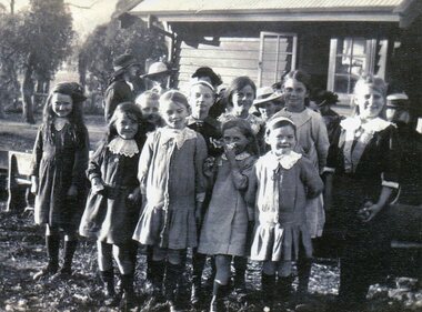
Photo - School Children Tawonga Primary School, Circa 1920 (estimate)
Tawonga is in the Kiewa Valley, where local farmers lived with their families. The school was originally opened July 27 1880, situated on 8 acres near the current township of Tawonga. The school was erased by fire in 1900 and all records destroyed. The school was then moved to the Old Tawonga Hall. In 1910, the school was shifted to its present site on 3 acres of land donated by Frank Cooper. The school building and attendance continued to grow, especially during construction of the Kiewa Hydro Electric Scheme.Tawonga Primary School has educated the local farming and town children for many years. It is an excellent source of the names of the local families of the time ie: Vera Ryder – front row, far right (little girl with the wide headband.)Copy of black and white photograph of pupils at Tawonga Primary School. Circa 1920 (estimate)tawonga primary school, kiewa valley -
 Kiewa Valley Historical Society
Photo - School Children Tawonga Primary School, Circa 1920 (estimate)
Tawonga is in the Kiewa Valley, where local farmers lived with their families. The school was originally opened July 27 1880, situated on 8 acres near the current township of Tawonga. The school was erased by fire in 1900 and all records destroyed. The school was then moved to the Old Tawonga Hall. In 1910, the school was shifted to its present site on 3 acres of land donated by Frank Cooper. The school building and attendance continued to grow, especially during construction of the Kiewa Hydro Electric Scheme.Tawonga Primary School has educated the local farming and town children for many years. It is an excellent source of the names of the local families of the time. Copy of black and white photograph of pupils at Tawonga Primary School. Circa 1920 (estimate)tawonga primary school, kiewa valley -
 Kiewa Valley Historical Society
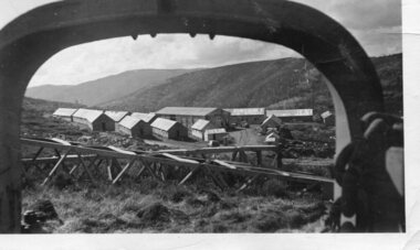
Photograph - Pretty Valley camp including workman's huts, Pretty Valley
At the Pretty Valley Dam site erection of staff quarters was completed in April, 1947 and accommodation for workmen commenced in 1948 but suspended on 11th May for winter and resumed on 9th November. Construction of this camp was completed in 1949. A large dam was proposed at this site but was never constructed. Instead a small diversion dam was built which diverts water either to Rocky Valley Dam or to McKay Creek Power Station.An historical record of the type of accommodation provided for workmen during the construction of the Kiewa Hydro Scheme during the 1940's/50'sBlack and white photograph of Pretty Valley camp showing workman's huts and construction materials.Handwritten on back of photograph in blue pen - Pretty Valleypretty valley, workmen's huts, victorian alps, secv -
 Kiewa Valley Historical Society
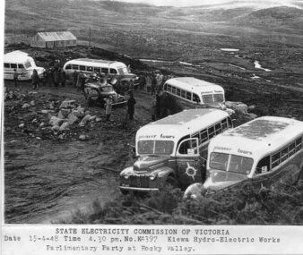
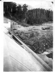
Photograph - Parlimentary Party visiting Rocky Valley Dam site, 15-4-1948
This photograph was taken during construction of the Rocky Valley Dam and wall. Work was commenced in early 1947 but had to be suspended during winter and then resumed in October. Work continued in 1948 with the establishment of work facilities and, at the dam site, the river was diverted through a temporary pipeline. Rocky Valley and associated spillway and outlet works were completed in 1959.A pictorial record of the construction of the rock and earth filled dam wall at Rocky Valley. Shows the extent of the project undertaken and the level of importance of the project as indicated by the large representation at the parliamentary party visit on 15/4/48.Photocopy of black and white photograph of parliamentary party visiting Rocky Valley Dam site 15/04/1948Typed on the bottom of photocopy - State Electricity Commission of Victoria. Date: 15-4-48 Time: 4.30pm No: K4397. Kiewa Hydro-Electric works. Parlimentary Party at Rocky Valleyrocky valley dam, parliamentary party, secv -
 Kiewa Valley Historical Society
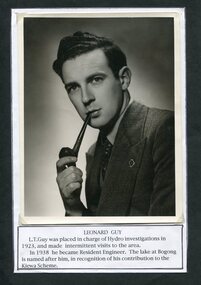
Photograph of Leonard Guy resident engineer for SECV
In 1940 Field Headquarters for the Kiewa Scheme were established at Bogong with office, workshop facilities and accommodation for workmen, staff and some families constructed. (There had been a 'tent camp' on this site in 1939 but was destroyed by bushfires) Construction of accommodation continued until 1947. Lake Guy was named after Mr. L.T. Guy Mr L.T. Guy was placed in charge of Hydro investigations in 1923 and became the resident engineer for the Kiewa Valley Hydro Scheme in 1938. He was the Resident Engineer in charge of construction work and associated activities on the Kiewa area. He held this position from 1939 to November 1946 when he was transferred to Head Office. Black and white photograph of Mr Leonard Guy. Photo mounted on black background with typed information regarding Mr Guy underneath, Printed in black ink, on white paper underneath photograph – LEONARD GUY L.T. Guy was placed in charge of Hydro Investigations in 1923 and made intermittent visits to the area. In 1938 he became Resident Engineer. The lake at Bogong is named after him in recognition of his contribution on the Kiewa Scheme. leonard guy, secv, bogong -
 Kiewa Valley Historical Society
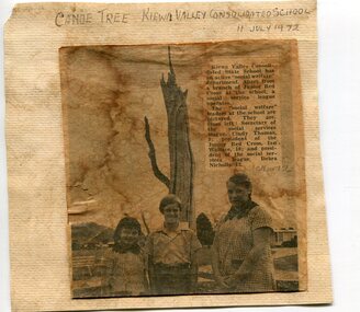
Newspaper clipping 11/7/72 Canoe tree in Kiewa & Photo-Tawonga Homestead
1. Kiewa Valley Consolidated School was established in 1953 combining Dederang North, Kergunyah, Gundowring, Kiewa, Gundowring Upper, Red Bluff, Charleroi and Gundowing North schools on a 10 acre site with 11 rooms at Kiewa. The bark was cut from the canoe tree, by aboriginal craftsmen, to produce a canoe for fishing in the rivers running through the Kiewa Valley either before or just after the 1800's. The tree trunk, located at Kiewa, would have been used at the beginning of European settlement in the Kiewa Valley or just before contact was made. 2. Pictorial record of the graves of early pioneers C Ibbotson, Mrs Elizabeth Eyre and John Eyre who died between 1858 – 1904, all located at Tawonga Homestead 1. The above schools are in the Kiewa Valley. The date and number of combined schools give insight into the change in population and families in the Kiewa Valley before and after 1953. The tree was found along the Kiewa River and indicates that Aborigines lived by the river and used tree bark to craft canoes to cross rivers and to fish in the deeper sections of the river. 2. Pictorial record of the early history of Kiewa Valley pioneers whose descendants have lived and worked in the Kiewa Valley for many years 1. Newspaper article of local school children visiting a canoe tree in Kiewa July 11, 1972. mounted on buff card 2. Black and white photo of pioneer graves at old Tawonga Homestead. Mounted on buff card 1. Handwritten in black ink above newspaper clipping ‘Canoe Tree Kiewa Valley Consolidated School. 11 July, 1972’ Handwritten in pencil at bottom of article ’10 Nov. ‘72’ 2. Handwritten in black ink above photo ‘Tawonga Homestead graves’ Handwritten below photo ‘T Ibbotson D. 1858, Elizabeth Eyre D. 1879, John Eyre D 1879, John Eyre D. 1904 tawonga homestead, canoe tree at kiewa, tawonga graves -
 Kiewa Valley Historical Society
Photographs x 2 1. Lake Guy & Bogong Village 2. Bulldozer moving rocks
1. In 1940 Field Headquarters for the Kiewa Scheme were established at Bogong with office, workshop facilities and accommodation for workmen, staff and some families constructed. (There had been a 'tent camp' on this site in 1939 but was destroyed by bushfires) Construction of accommodation continued until 1947. A total of 40 houses plus a hostel for single staff, post office, police station, medical centre and primary school all with water and sewerage and electricity supply. The staff hostel was known as Kiewa House and is now occupied by the Education Department. Lake Guy was named after Mr. L.T. Guy who was the Resident Engineer in charge of construction work and associated activities on the Kiewa area. He held this position from 1939 to November 1946 when he was transferred to Head Office. 2. Example of the type of heavy machinery used in clearing and building of Lake Guy, Bogong Village and Clover Dam 1. The Bogong Township was developed firstly as an accommodation centre (base camp) for construction workers employed under the Kiewa Hydroelectric Scheme. At the completion of the scheme, in the 1960's, the village was opened to public/tourism use. Strict environmental control has not allowed for any extensive redevelopment in tourist accommodation and basically restricted it to the accommodation initially built for the construction workers. Lake Guy is one of the many water storage reservoirs used to supply the power stations their main power to run the huge turbines generating the final product, electricity 2. Pictorial record of the types of machinery used in the development of Bogong Village and the Hydro-electricity scheme including the Clover Dam. Note the lack of safety equipment worn by construction workers of the period. 2 black and white photographs taken at Bogong 1. Lake Guy with Bogong Village in the background 2. Workman in bulldozer clearing rocks, possibly for construction at Bogong1. Handwritten in blue ink on back of photo 'Lake Guy showing Bogong Village' 2. No markingslake guy, bogong village, secv -
 Kiewa Valley Historical Society
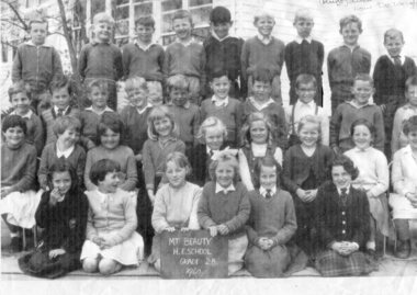
Photograph – Mt Beauty Higher Elementary School Grade 2B, 1960 – Black and white photocopy of original photograph
On Feb 3rd 1948, the Mt Beauty State School was opened with 28 pupils in all grades up to VII. Classes began in the SECV Recreation Hall, which was converted to classrooms during the school week and returned to a recreation hall on weekends for motion pictures and social occasions for SECV workers and their families. A new school building was opened in 1950 on the current school site, with an enrolment of 170 primary and secondary students. A further extension of 4 buildings was added in 1951 with a population increase to 303 students. In May 1953, the status of the school was raised to Higher Elementary School with a total of 403 students. In 1958, the school population rose to a high of 617 students with 436 in primary and 181 in secondary. In 1964, the status of the secondary section of Mt Beauty HES was raised to a High School and was moved to separate facilities in the west of town in September 1964 Pictorial history of children who attended Mt Beauty Higher Elementary School in 1960. Many of the students would have had parents working on the Hydro-Electric Scheme in and around Mt Beauty. Many of the children would also have been the descendants of parents who immigrated to Australia as foreign workers on the Hydro Electric Scheme such as Alex Van De Ruijt, whose parents were Dutch. Photocopy of a black and white class photograph of Mt Beauty H E School Grade 2B, 1960 Back row: Lawrence Woods, John Wayne, Terry Hertzog, Phillip Jervies, ?, Alex Van De Wright , ?John Sigmund, Wayne Shoebridge, Brian Harkin 3rd row: Doug Newbound, Roy Hetherington, ? Kevin Hills, Peter Renshaw, ? Grenville Gerecke, ?, Ken Thomas, Detlef Rueff, ?, not in picture Berndt Homfeld 2nd Row, ?, Lyn Plant, ?, Gabrielle Sigmund, ? Pauline Gerecke, Christine Harmer, ?, Lesley McDonald, not in picture, Jenny Richardson Front Row, ? Christine Pennery, Robyn Symons, ?, ?, Sue Mckendrick, ?, ? with a name may not be correct Chalk Board at front of children in photograph – MT BEAUTY H.E.SCHOOL GRADE 2B. 1960 Handwritten in top right hand corner of photograph, with arrow pointing to the boy 4th from the right Alex Van De Auigh (Ruijt) dutch now De Wright Handwritten on back of photograph – Top row: 6 from left (4th from Right) mt beauty school -
 Kiewa Valley Historical Society
12 small black and white photgraphs of Junction Dam and surrounding area, Photo No. 1 c1940, all others c 1948
Junction Dam is a reinforced slab and buttress type construction and was commenced in February, 1940 by Lewis Construction Company. Stiff leg derricks were erected at appropriate locations at the site of the dam and used for the disposal of excavated material and the placing of concrete. A rock crushing and screening plant was established at a site a short distance upstream from the dam site and concrete was supplied from a central mixing plant placed close to the upstream toe of the structure. The SEC took over the construction in April 1942 and the dam wall was completed in March, 1944. Bogong township was commenced in early 1940 with the construction of a workmen's camp housing 96 men, (known as Junction camp). Construction of housing for families commenced shortly after. Forty houses, plus office, workshops, stores and laboratory accommodation were completed over the next 5 years,Of historical significance as a pictorial record of Junction Dam, Lake Guy and Bogong Village, as the photos were taken only 4 years after completion and one photo taken on completion of the dam wall but before the lake was filled with water.12 small black and white photographs of Junction Dam, Bogong Village and surrounding area.Photo 1 - On the back upper edge in pen 'Junction Dam'. Then '12' in pencil, circular stamp, printed in centre 'Print by Willson White Albury'. Photo 2 - On the back upper edge in pen 'Junction Dam October 1948'. Stamp as no. 1 photo. Stamp '998L' lower centre. Photo 3 - on the back upper edge in pen 'Junction Dam October 1948'. Circular stamp with 'Kodak Print' . Lower centre back is stamped 'velox' and '998L'. Photo 4 - upper back, in ink - 'Junction Dam Spion Kopje in background. October 1948'. Stamps as photo no. 4. Photo 5 - upper back, in ink - 'Lake Guy (orange filter) October 1948'. Centre back, in pencil '29' and circular stamp with words 'Print by Willson White Albury'. Photo 6 - upper back edge 'Junction, Bogong from Radio Receiving Shack Dec. 1948'. In pencil '14'. Photo 7 - On back of photo 'View of Mountains from Little Arthur Fire Track October 1948'. Two circular stamps with 'Kodak Print', another two stamps - 'Velox' and '998L'. Photo 8 - On back in ink 'Loone's Store Bogong with Spion Kopje in background. October 1948'. Lower down, stamps 'Velox' and '998L'. Part of circular stamp with one word 'Kodak'. Photo 9 - on back in ink 'Junction Camp, Bogong Village & Lake Guy from Little Arthur Fire Track. October 1948'. Stamped across writing '998L'. Lower down stamped 'Velox' and circular stamp with words 'Kodak Print'. Photo 10 - on back in ink 'Junction Camp & Bogong Village Lake Guy in Foreground. October 1948'. Stamps as photo 9. Photo 11 - on back in ink 'Junction Camp & Bogong Village, Lake Guy in Foreground. October 1948'. Lower stamp '998L'. Photo 12 - 'Junction of Rocky & Pretty Rivers with tennis courts in foreground October 1948' . Circular stamp with words, 'Print by Willson White Albury'. Number '29' written pencil.junction dam; bogong village; kiewa hydro electric scheme; lake guy -
 Kiewa Valley Historical Society
7 small black and white photographs of Pretty Valley, c1948
In 1947 it was proposed to construct a dam on the Pretty Valley branch of the East Kiewa River. This was part of the initial planning in 1937. The Pretty Valley Reservoir was to be part of a pumped-storage scheme with a pumping station located immediately below the main structure. Preparatory work was commenced in 1946 with erection of staff accommodation. Between 1947 and 1950 the main camp was erected, access roads, constructed and banks and benches at the dam site undertaken. Following the financial crisis in 1951, a review of the scheme was carried out and work ceased in June 1951. Construction of the dam was deleted from the programme of works and all buildings removed.A pictorial history of part of the initial planning in 1937 for a dam to be constructed at Pretty Valley as part of the Kiewa Hydro Electric Scheme.7 small black and white photographs of Pretty ValleyAll photos have a circular stamp on the back with 'Print by Willson White Albury' enclosed. Photo 1 - on the back, handwritten in ink 'New 22Kv pump line - Pretty Valley Nov. 1948'. In pencil '18'. Photo 2 - On the back, handwritten in ink 'Pretty Valley - Staff mess on right Nov. 1948'. In pencil '18'. Photo 3 - On the back, handwritten in ink 'Pretty Valley Basin - looking S.E. Nov. 1948'. In pencil '5'. Photo 4 - On the back, handwritten in ink 'New pump 22Kv line, Pretty Valley - looking towards Mt. Mackie. Nov. 1948'. In pencil '5'. Photo 5 - On the back, handwritten in ink 'Pretty Valley. Mt. Cope just out of picture extreme right. Nov. 1948'. In pencil '78'. Photo 6 - on the back, handwritten in ink 'View from Pretty Valley Ruined Castle in Background Nov. 1948'. In pencil '78'. Photo 7 - on the back, handwritten in ink 'Pretty Valley Pump line (Nov. 1948)'. In pencil'78'.construct, dam, pretty valley